319 acre plot of land situated on Ocean Bay in St. James Parish, part of the "Hodge Grant," shows some land details like creeks and cypress ponds. Names associated with this plat are T. Hataway, Hodge, W.B. Guerard, Benjamin Fort, B.P. Colburn, Hiram Hodge , R.J. Morrison and W.H. Mellard. Notable geographic locations include Ocean Bay, St. James Parish and Santee.
25 acres of land containing two dams, a reserve, and pine and oak trees owned by George Holmes near 7 mile south of lands owned by J. Meetze. Names associated with this plat include George Holmes, J. Meetze and Simons.
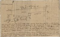
Lands of Paul Guerard called “The Hut," shows a public road and creeks, includes measurements. Names associated with this plat are Parker, W.B. Guerard, William Blacklock, Micah Jenkins, Thomas Humscoube, and Paul C. Grimball.
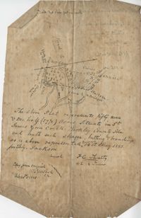
Plat contains 59 (1/2) acres. Plat contains the road to Ladson running west to east through the property the plat also includes the location of the house as well as the brickyard. Names associated with this plat include E.J. Jackson, M. Brailsford, Caines, Edon, F.C. Shutty and W.B. Guerard. Notable geographic locations include St. James Parish and Goose Creek.
Office copy of a survey of 31 acres of land for Dr. R. H. Martin in Berkeley County. Notable geographic locations include Wappoo Road and Mill Tract. Names associated with this plat are R.H. Martin, G.G. DuPont, and W.B. Guerard.
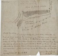
Plan of approximately 1500 acres on Black River near Georgetown part now belonging to Kinloch and Gadsden. Names associated with this plat are Gadsden, Kinloch, Alston, Thomas Gadsden, James Lloyd, and Morreau [?] Sarrazin.
Plat contains land on the Santee River; acreage unknown. No structures are included. Names associated with this plat are S.G. Staney, A.M. Rickenbacher, and Fred J. Smith. Notable geographic locations include the Santee River.
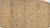
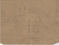
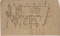
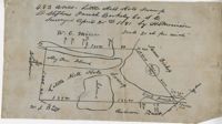
480 acre lot called Little Hell Hole Swamp, includes two islands and surrounding property owners, doesn't include land type. Names associated with this plat are H. Morrison, W.C. Miller, W.J. Ball, Issac Bishop and Anderson. Notable geographic locations include Hog Pen Island, Berkeley County, St. Stephen's Parish, and Little Hell Hole Swamp.
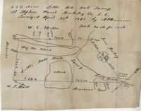
483 acre plot of Little Hell Hole Swamp, includes islands and surrounding property owners doesn't include land detail. Names associated with this plat are H.S. Morrison, Isaac Bishop, W.C. Miller, W.J. Ball, and Anderson. Notable geographic locations include St. Stephens Parish, Hog Pen Island, Little Hell Hole Swamp, and Berkeley County.
3.71 Acres of highland near marsh adjacent to Meeting Street Road. Names associated with this plat are Karl W. Ruth, A.F.C. Kramer, and S. Louis Simons.
Limit your search
John McCrady Plats and Deeds Collection✖[remove]10