This album consists of photographs taken at Pinehurst Tea Plantation located in Summerville, SC and owned by Professor Charles Upham Shepard Senior. The photographs depict the property, multiple tea gardens, tea processing, schools and other buildings located on the property, and tea plantation workers (including the African-American students who attended Pinehurst School).
This album consists of photographs on the subject of tea cultivation and life in Japan. The photographs in this album are hand-tinted color, albumen prints mounted on paper. All captions are from the album.
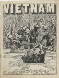
Anti-war comic entitled, "Vietnam," providing arguments against the Vietnam War with an emphasis on the injustices with regard to African American enlisted soldiers.
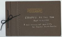
This is a photo album documenting a trip taken by a few members of the Agricultural Society of South Carolina on September 13-14, 1950 to North Carolina to consider whether coastal South Carolina could capitalize on the grape and wine industry as NC had so successfully done. The group visits an experiment station, inspects different vineyards, observes a harvest, and learns about varieties of muscadine grapes.
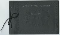
This photograph album documents a trip taken by members of the Agricultural Society of South Carolina from February 13, 1950 to February 18, 1950. The group visits ranches, reservations and an experiment station to observe Florida's growing beef-cattle industry.
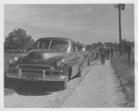
This collection consists of select photographs from the 'Charleston County Pasture Tour, 1951' photograph album. The photographs depict walks through pastures, cattle, demonstrations, group photos and a shared meal.
Based on the inscription and date, it is likely that this sketchbook was the joint work of two brothers, Alexander Fraser (1750-1798) and Charles Fraser (1782-1860). Highlights of this sketchbook include some of Charles Fraser's earliest Lowcountry landscape scenes, and several theatrical views, some of which may be the work of his brother, Alexander.
Photograph album of Laura M. Bragg, 1881-1978. Bragg was the founder and first librarian of the Charleston Free Library in 1931 and was the director of the Berkshire Museum in Pittsfield, Massachusetts from 1932-1939. Includes Citadel and Virginia Military Institute commencement invitations, postcards and photographs of Miss Bragg with Chinese cadets.
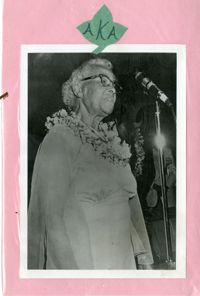
Scrapbook pages made of pink construction paper with a decorative vine theme, leaves made of green construction paper. Media types include photographs, newspaper clippings, typescript pages, correspondence, and invitations. All dated material generated in the 1970s.
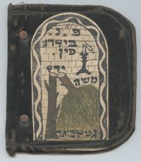
This memorial photograph album documents the funeral of Moshe Yidel Gelbart. Gelbart died of appendicitis on February 25, 1935, in Mogielnica, Poland. The album, made of fabric and paper, contains black and white photographs that chronicle Gelbart's funeral procession, his casket, mourners, and gravesite, including an image of Gelbart with his wife and son eight days before his death. The cover of this book pictures a broken candle and a broken tree, symbolic of a life cut short. Each page includes decorative labels in Hebrew. This album was given to one of his two brothers, George Goldberg or Israel Geldbart, in South Carolina.
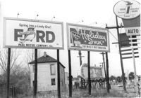
Billboards on lot, on site affected by the construction of the Crosstown. Address: 34-36 Lee Street. Surveyor notations on back of photo: "Dkt.: 10.518. Property owner: Turner Advertising. Tract: 65. Station: 51±45 Rt. & Lt. N.B. lane Route 17. Date: Mar. 7, 1963. Signs. [See collection description for explanation of surveyor notations.]
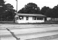
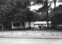
Building on site affected by the widening of U.S. Route 17. Appears to have previously been a store. Presumably located in Mount Pleasant or vicinity. Surveyor notations on back of photo: "Dkt.: 10.597. Property owner: Geo. G. Browder, Jr. Tract: 22. Station: 275+20 Lt. Date: Sept. 17, 1968." [See collection description for explanation of surveyor notations.]
House and lot on site affected by the widening of U.S. Route 17. Small roadside stand on property. Presumably located in Mount Pleasant or vicinity. Surveyor notations on back of photo: "Dkt.: 10.597. Property owner: Dorothy R. Ayers, et al. Tract: 12-A213. Station: 259+50Rt. looking north. Date: Sept. 17, 1968." [See collection description for explanation of surveyor notations.]
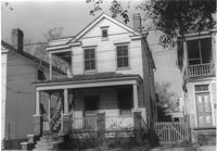
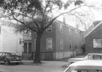
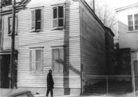
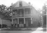
House on St. Phillip Street at the corner of Sheppard Street, on site affected by the construction of Interstate 26 (I-26). Address: 270 St. Philip Street. Surveyor notations on back of photo: "Dkt.: 10.517. Property owner: Hattie Givens. Tract: 90. Station: 24+80 Lt. Northbound Lane Route 17. Date: March 5, 1963. In R/W - Bought." [See collection description for explanation of surveyor notations.]
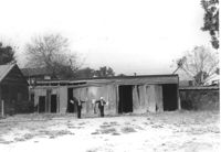
Buildings on site affected by the widening of U.S. Route 17. Wagon Wheel Furniture in foreground. Presumably located in Mount Pleasant or vicinity. Surveyor notations on back of photo: "Dkt.: 10.597. Property owner: Erma B. Salvo. Tract: 18. Station: 268± Lt. Date: Sept. 17, 1968." [See collection description for explanation of surveyor notations.]
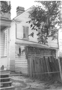
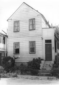
House (rear view) on site affected by the construction of Interstate 26 (I-26). Address: 83 Fishburne Street. Surveyor notations on back of photo: "Dkt.: 10.517. Property owner: Georgette H. Gilchrist. Tract: 108. Station: 23+75 Lt. Southbound Lane Route 17. Date: March 5, 1963. In R/W - Bought." [See collection description for explanation of surveyor notations.]
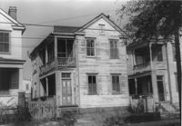
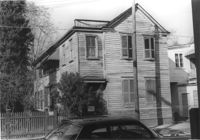
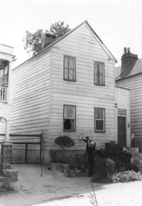
House (corner view, rear) on site affected by the construction of Interstate 26 (I-26). Address: 3 A Street (now 3 Walnut Street). Surveyor notations on back of photo: "Dkt.: 10.517. Property owner: Theresa H. Walker. Tract: 48. Station: 5952+70 Lt. - Line 6. Date: February 21, 1963. In R/W - Bought." [See collection description for explanation of surveyor notations.]
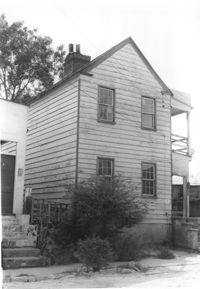
House (corner view, rear) on site affected by the construction of Interstate 26 (I-26). Address: 1 A Street (now 11 Walnut Street). Surveyor notations on back of photo: "Dkt.: 10.517. Property owner: Theresa H. Walker. Tract: 49. Station: 5953+15 Lt. - Line 6. Date: February 21, 1963. In R/W - Bought." [See collection description for explanation of surveyor notations.]
House on site affected by the construction of Interstate 26 (I-26). Address: 7½ A Street (now 7½ Walnut Street), at corner of C Street. Surveyor notations on back of photo: "Dkt.: 10.517. Property owner: H.B. Hogg, Est. Tract: 47. Station: 5951+85 Rt. - Line 6. Date: February 21, 1963. In R/W - Bought." [See collection description for explanation of surveyor notations.]
House on site affected by the construction of Interstate 26 (I-26). Address: 92 Lee Street (rear). Surveyor notations on back of photo: "Dkt.: 10.517. Property owner: Robert L. Chamberlain, et al. Tract: 51. Station: 5953+60 CL - Line 6. Date: February 21, 1963. In R/W - Bought." [See collection description for explanation of surveyor notations.]
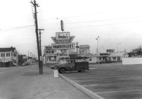
View on Spring Street from the Hardee's parking lot, on site affected by the construction of the Crosstown. Address: 223 Spring Street. Sea Food Dining Room in background, and signage for Hardee's and Everett's Hotel and Patio [restaurant?]. Surveyor notations on back of photo: "Dkt.: 10.524. Property owner: Sarah Chinnis Sanders. Tract: 157. Station: 13+75 Rt. Spring Street. Date: Dec. 2, 1964." [See collection description for explanation of surveyor notations.]
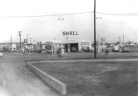
Shell gas station, on site affected by the construction of the Crosstown. Address: 233 Spring Street. View of street corner. Surveyor notations on back of photo: "Dkt.: 10.524. Property owner: Shell Oil Co. Tract: 155. Station: 9+00 Rt. Spring Street. Date: Dec. 2, 1965. Panoramic view." [See collection description for explanation of surveyor notations.]
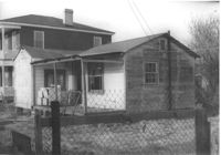
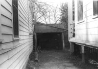
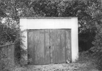
Shed or garage on site affected by the construction of the Crosstown. Address: 287 Coming Street. Surveyor notations on back of photo: "Dkt.: 10.524. Property owner: John T. Bowden. Tract: 152. Station: 21+10 Lt. S.B. lane. Date: Dec. 2, 1964. In R/W - Bought." [See collection description for explanation of surveyor notations.]
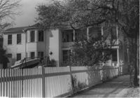
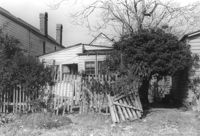
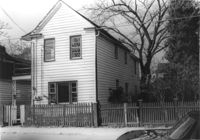
Lot with picket fence and side view of house on site affected by the construction of the Crosstown. Address: 285 Coming Street. Surveyor notations on back of photo: "Dkt.: 10.524. Property owner: Gladys S. Wilson. Tract: 151. Station: 21+40 Lt. S.B. lane. Date: Dec. 2, 1964. In R/W - Bought." [See collection description for explanation of surveyor notations.]
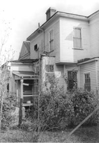
House (side view, rear) on site affected by the construction of the Crosstown. Address: 110 Sheppard Street. Surveyor notations on back of photo: "Dkt.: 10.524. Property owner: Alma L. Browning, et al. Tract: 147. Station: 19+95 CL S.B. lane. Date: Dec. 2, 1964. In R/W - Bought." [See collection description for explanation of surveyor notations.]
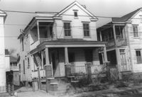
House on site affected by the construction of the Crosstown. Address: 118 Sheppard Street. Surveyor notations on back of photo: "Dkt.: 10.524. Property owner: John H. Jenkins. Tract: 143. Station: 18+60 CL Lt. S.B. lane. Date: Dec. 2, 1964. In R/W - Bought." [See collection description for explanation of surveyor notations.]
House on site affected by the construction of the Crosstown. Address: 118 Sheppard Street. Surveyor notations on back of photo: "Dkt.: 10.524. Property owner: John H. Jenkins. Tract: 143. Station: 18+60 CL Lt. S.B. lane. Date: Dec. 2, 1964. In R/W - Bought." [See collection description for explanation of surveyor notations.]
House on site affected by the construction of the Crosstown. Address: 116 Sheppard Street. Surveyor notations on back of photo: "Dkt.: 10.524. Property owner: Margaret Oree. Tract: 144. Station: 18+90 CL S.B. lane. Date: Dec. 2, 1964. Condemned." [See collection description for explanation of surveyor notations.]
House on site affected by the construction of the Crosstown. Address: 116 Sheppard Street. Surveyor notations on back of photo: "Dkt.: 10.524. Property owner: Margaret Oree. Tract: 144. Station: 18+90 CL S.B. lane. Date: Dec. 2, 1964. Condemned." [See collection description for explanation of surveyor notations.]
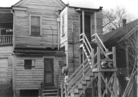
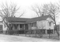
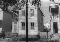
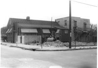
House (freedman's cottage) on site affected by construction of the Crosstown. Address: 165 Line Street. Surveyor notations on back of photo: "Dkt.: 10.524. Property owner: Elias L. Frasier, et al. Tract: 92. Station: 81+25 Lt. Date: Dec. 1, 1964. In R/W - Bought." [See collection description for explanation of surveyor notations.]
Shed, on site affected by the construction of the Crosstown. Address: 259 Ashley Avenue. Surveyor notations on back of photo: "Dkt.: 10.524. Property owner: Madeline H. LaRoache, et al. Tract: 76. Station: 77+90 Rt. Date: Oct. 14, 1964. In R/W - Bought." [See collection description for explanation of surveyor notations.]
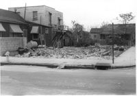
House (rear view) and backyard on site affected by the construction of the Crosstown. Address: 165 Line Street. Surveyor notations on back of photo: "Dkt.: 10.524. Property owner: Elias L. Frasier, et al. Tract: 92. Station: 81+25 Lt. Date: Dec. 1, 1964. In R/W - Bought." [See collection description for explanation of surveyor notations.]
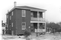
House on site affected by the construction of the Crosstown. Address: 501 Rutledge Avenue. Surveyor notations on back of photo: "Dkt.: 10.524. Property owner: William DeLesline, et al. Tract: 108. Station: 84+85 Lt. Date: Dec. 1, 1964. In R/W - Bought." [See collection description for explanation of surveyor notations.]
House on site affected by the construction of the Crosstown. Address: 501 Rutledge Avenue. Surveyor notations on back of photo: "Dkt.: 10.524. Property owner: William DeLesline, et al. Tract: 108. Station: 84+85 Lt. Date: Dec. 1, 1964. In R/W - Bought." [See collection description for explanation of surveyor notations.]
House on site affected by the construction of the Crosstown. Address: 160 Line Street. Surveyor notations on back of photo: "Dkt.: 10.524. Property owner: John Meyer, Est. Tract: 101. Station: 83+30 CL. Date: Dec. 1, 1964. In R/W - Bought." [See collection description for explanation of surveyor notations.]
House on site affected by the construction of the Crosstown. Address: 160 Line Street. Surveyor notations on back of photo: "Dkt.: 10.524. Property owner: John Meyer, Est. Tract: 101. Station: 83+30 CL. Date: Dec. 1, 1964. In R/W - Bought." [See collection description for explanation of surveyor notations.]
House on site affected by the construction of the Crosstown. Address: 162 Line Street. Surveyor notations on back of photo: "Dkt.: 10.524. Property owner: James Washington. Tract: 100. Station: 82+85 Lt. Date: Dec. 1, 1964. In R/W - Bought." [See collection description for explanation of surveyor notations.]
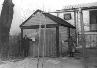
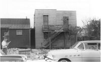
Storage shed or garage on site affected by the construction of the Crosstown. Address: 160 Line Street. Surveyor notations on back of photo: "Dkt.: 10.524. Property owner: John Meyer, Est. Tract: 101. Station: 83+25 Lt. Date: Dec. 1, 1964. In R/W - Bought." [See collection description for explanation of surveyor notations.]
House (corner view, street elevation) and lot on site affected by the construction of the Crosstown. On Cooper Street; address unknown. View of street corner. Surveyor notations on back of photo: "Dkt.: 10.518. Property owner: Louise McLead Drayton. Tract: 30-B. Station: 14+60 Lt. (Cooper Street). 41+70 Rt. (U.S. Rt. 17). Date: Apr. 20, 1965. Partially in R/W." [See collection description for explanation of surveyor notations.]
Lot and house on corner, on site affected by the construction of the Crosstown. On Cooper Street; address unknown. View of street corner. Surveyor notations on back of photo: "Dkt.: 10.518. Property owner: Louise McLead Drayton. Tract: 30-B. Station: 14+60 Lt. (Cooper Street). 41+70 Rt. (U.S. Rt. 17). Date: Apr. 20, 1965. Partially in R/W." [See collection description for explanation of surveyor notations.]
House (side view) on site affected by the construction of the Crosstown. On Cooper Street; address unknown. Surveyor notations on back of photo: "Dkt.: 10.518. Property owner: Louise McLead Drayton. Tract: 30-B. Station: 14+60 Lt. (Cooper Street). 41+70 Rt. (U.S. Rt. 17). Date: Apr. 20, 1965. Partially in R/W." [See collection description for explanation of surveyor notations.]
House and shed (rear view) on site affected by the construction of the Crosstown. Address: 182 Spring Street. Surveyor notations on back of photo: "Dkt.: 10.524. Property owner: A.J.R. Kornahrens. Tract: 27. Station: 65+75 Rt. Date: Oct. 13, 1964. In R/W - Bought." [See collection description for explanation of surveyor notations.]
House on site affected by the construction of the Crosstown. Address: 147 President Street. Surveyor notations on back of photo: "Dkt.: 10.524. Property owner: Frank Chinners. Tract: 31. Station: 67+60 Rt. Date: Oct. 13, 1964. Partially In R/W - Bought." [See collection description for explanation of surveyor notations.]
House on site affected by the construction of the Crosstown. Address: 9 Presidents Place. Surveyor notations on back of photo: "Dkt.: 10.524. Property owner: Mary Robinson, Est. Tract: 8. Station: 63+40 Rt. Date: Oct. 13, 1964. In R/W - Bought." [See collection description for explanation of surveyor notations.]
House on site affected by the construction of the Crosstown. Address: 9 Presidents Place. Surveyor notations on back of photo: "Dkt.: 10.524. Property owner: Mary Robinson, Est. Tract: 8. Station: 63+40 Rt. Date: Oct. 13, 1964. In R/W - Bought." [See collection description for explanation of surveyor notations.]
House on site affected by the construction of the Crosstown. Address: 11 Presidents Place. Surveyor notations on back of photo: "Dkt.: 10.524. Property owner: Lucille Smalls. Tract: 9. Station: 63+10 Rt. Date: Oct. 13, 1964. In R/W - Bought." [See collection description for explanation of surveyor notations.]
Structure and lot on site affected by the construction of the Crosstown. Address: 160 Cannon Street. Surveyor notations on back of photo: "Dkt.: 10.524. Property owner: Mabel M. Cecil McIherney. Tract: 7. Station: 62+75 CL Lt. Date: Oct. 13, 1964. Portion In R/W - Bought." [See collection description for explanation of surveyor notations.]
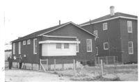
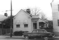
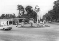
Gulf gas Station [Berkeley Gulf Service], on site affected by the widening of State Road 13 (Remount Road), with directional signs for Yeaman's Hall and Hanahan Baptist Church. Surveyor notations on back of photo: "Dkt.: 10.562. Property owner: C.D. Hoffecker Estate. Tract: 24. Date: Jul. 12, 1967." [See collection description for explanation of surveyor notations.]