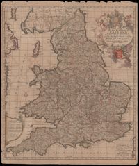
A very informative map of the road network with England and Wales. This map was cooperatively published by Nicholas Visscher (1649-1702), a cartographer from Amsterdam, and John Overton (1640-1708), a publisher from London. The imprint of Visscher and Overton tells the reader that the map may be bought in both Amsterdam and London. The maps title is enclosed in a decorative cartouche on the upper right. At the top of the title is the royal coat of arms supported by a lion and a unicorn and at the bottom is the shield of England. Amsterdam. 52 x 62cm.
Map of the Italian piedmont by Thomas Blaeu (1596-1673). Similar to Tabula Generalis Sabaudiae by Blaeu and slightly overlapping in coverage. First published by Blaeu's heirs after his death in his town book of Savoy and Piedmont. Map was designed by Giovanni Tommaso Borgonio (1620-1683) and engraved by Johannes de Broen (1649-1730). Amsterdam. 52 x 62cm.
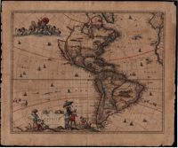
In this map by Gerrit van Schagen (1642-1690) California is a large island, there is one Great Lake (Lac contenant), a large open lake in place of the western Great Lakes, and the conjectural Northwest Passage, with the Straits of Anian. The elaborate title cartouche at the bottom left contains scenes of native Americans hunting, panning for gold and a chief standing beneath an umbrella. Also, the map shows other small illustrations: a war being waged by Indians in South America and a figure lying in a hammock. There is a large vignette at the top left of Neptune and his sons, the Tritons. 51 x 62cm.
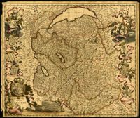
Ornate map of Savoy in the French alps by Joan Blaeu (1596-1673). Map is richly detailed with pictorial relief of mountains and watersheds. Putti hold the coat of arms of the dukes of Savoy above the title cartouche in the lower left corner. Other family crests from the regional duchies and baronies ring the map. First published by Blaeu's heirs after his death in his town book of Savoy and Piedmont (Theatrum Sabaudiae). Map was designed by Giovanni Tommaso Borgonio (1620-1683) and engraved by Johannes de Broen (1649-1730). Amsterdam. 52 x 62cm.
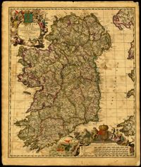
Decorative map of Ireland by Nicolaes Visscher (1649-1702). Impressive title cartouche with Pan and the Gaelic harp. Highly decorative scale of miles references William III, king of England, Scotland and Ireland 1689-1702. Visscher created this map shortly after William Petty's exhaustive survey of Ireland (the Down Survey) was published. Amsterdam. 52 x 62cm.
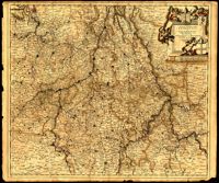
This map by Theodore Danckerts (1663-1727) details the bishoprics of Liege, Cologne and Trier and the duchies of Berg and Julich. Map covers the area surrounding the Meuse, Rhine and Moselle rivers and includes parts of modern day Belgium, the Netherlands, Germany, Luxembourg and France. Decorative title cartouche with putti holding the shields of the regions. Amsterdam. 52 x 62cm.
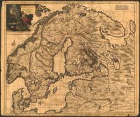
Map of Scandinavia by Justus Danckerts (1635-1701) includes the Baltic and part of Russia. The title cartouche with an armorer's forge and Swedish coat of arms probably alludes to Sweden's power in the late seventeenth century. 52 x 62cm
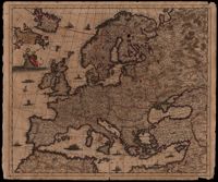
Map of Europe by Justus Danckerts (1635-1701) includes western Russia and Iceland. The title cartouche on left supported by putti. Other embellishments show the abduction of Europa by Zeus, a sea monster and ships on the oceans. Amsterdam. 52 x 62cm.
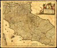
Map of central Italy by Frederick de Wit (1630-1706) showing the grand duchy of Tuscany and the papal states. Title cartouche is decorated with the ball-motif shield of the Medici family; the papal states are represented by the Keys of St. Peter on a shield. Detail on the map includes a road that extends from Rimina on the Gulf of Venetia to Piacenza in the northeast. Amsterdam. 52 x 62cm.