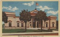
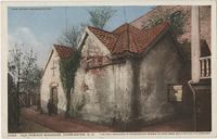
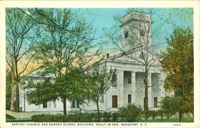
Postcard of the front of the Charleston Museum. Back of postcard reads: "The Charleston Museum is the oldest museum in North America. It was founded in 1773. It has an excellent collection of natural history groups and Low Country subects."
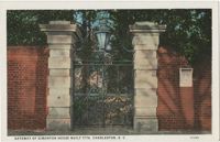
Postcard of the Sword Gate at Simonton House in Charleston, S.C. Back of postcard reads, "The Simonton house at 32 Legare Street was built in 1776. These noted gates and gateway were placed here between 1815-1820. The sword gates are considered the finest examples of early wrought iron work."
A typed copy of a 1782 letter from Francis Marion to William Alston in which he orders him to take command of new companies to serve in Georgetown, South Carolina, and watch for incoming vessels.
Copy of a plat of 250 acres laid out to Abraham Michau on the north side of Santee River and “now belonging to John Pedro." Names associated with this plat are Abraham Michau, John Pedro, George Hunter and James Glen. Notable geographic locations include the Santee River, Prince Frederick Parish and Georgetown District.
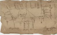
876 acre plot for Simpson, shows roads, houses, and rivers/creeks, no names on any of the details, includes surrounding tracts of lands and trees on the property boundaries. Names associated with this plat are Simpson, Keith, James Gray Wiase, and Charles Johnston.
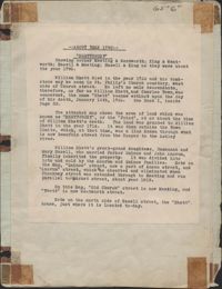
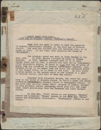
This one-page typed document provides information regarding the property at the East end of Calhoun Street, known as Gadsden's Wharf. The land ownership is traced back to 1696 under Issac Mazyck. Land development beginning in 1746 under Captain George Anson is also discussed, including the construction of a canal and wharf in Charleston. Changes in street names since the city's early days are also mentioned.
Provided on the front of this two-sided typed document is information regarding the property at the East end of Calhoun Street, known as Gadsden's Wharf. The land ownership is traced back to 1696 under Issac Mazyck. Land development beginning in 1746 under Captain George Anson is also discussed, including the construction of a canal and wharf in Charleston. Changes in street names since the city's early days are also mentioned. A small piece of paper taped to the back reads: "Kindness of: Mr. Gedney M. Howe."
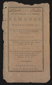
This is a Sandy Island plantation journal written inside of the South Carolina and Georgia Almanac for the year 1797. The plantation journal documents the planting of crops (rice, corn and potatoes), slave records (including runaway slaves), accounts, the weather, and business relations with Laurel Hill Plantation.
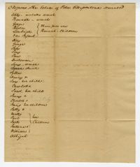
A document with the title "Negroes, The Estate of Peter Villepontoux Deceased" in which the writer lists the names of enslaved men, women and children. Makes notation "Abby-mulatto wench" as well as the relationships between slaves.
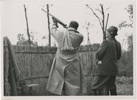
Photograph of Galeazzo Ciano taking aim at a target. Photographs taken by the “official photographer, Schmidtbauer,” a member of the “NSKK Bildbericht Sonderstaffel W,” a photography group incorporated within the National Socialist Motor Corps (NSKK).
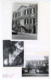
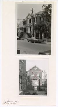
Three black and white photographs of No. 18 Bull Street: Top (front façade facing south on Bull Street); Middle (side elevation); Bottom (rear south elevation). The three photographs are taped to a beige colored paper. The photographs are overlaid on top of each other. There is a white border around each of the photographs. The paper is labeled "18 Bull St. #813-11-6." The structure is a three-story Adamesque style structure made of brick construction. The structure has a pitched roof with an elevated Palladian entryway and centered front and back door. The middle and bottom photographs show the side and back of the structure with trees in front of the structure and a yard.
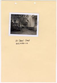
Black and white photograph of No. 20 Colonial Street. The photograph is stapled to a beige sheet of paper with two holes punched through the top. The paper is labeled "20 Colonial Street BAR #835-11-21." There is a white border surrounding the photograph. The photograph shows a gravel path in between No. 20 Colonial Street and the neighboring structure to the right. The corner of the front facade/east elevation of No. 20 Colonial Street is visible as well as the corner of the front facade/east elevation and south elevation of the neighboring structure. There is foliage obstructing the view of the exterior of the first floor of No. 20 Colonial Street.
Two black and white photographs of the main building and outbuilding of No. 18 Bull Street: Top (front façade); Bottom (detached outbuilding to the right of the front façade). The two photographs are taped to a white sheet of paper labeled on the bottom left corner as "18 Bull St. #813-11-6." The top photograph shows the three-story front facade of the Adamesque style main structure. The main structure has a pitched roof with an elevated Palladian entryway and centered front door. The bottom photograph shows the two-story outbuilding with a pitched roof and a Palladian entryway matching the one found on the facade of the main house. Both structures are of brick construction. The bottom photograph also has a hand drawn red “X” over the entire structure. The top photograph shows cars, electric poles, and trees in front of the building's three-story facade with its neighboring building, No. 20 Bull Street, to the back right.
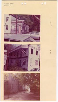
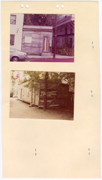
Three colored photographs of No. 18 Duncan Street: Top (front facade of outbuilding); Middle (corner of front facade/north elevation and east elevation); Bottom (side elevation). The photographs are stapled to a beige sheet of paper with four holes punched through the top. The paper is labeled "18 Duncan Street" with the application number "BAR #8410-24-1." The structure at No. 18 Duncan Street is a two-and-a-half story Charleston Single style structure. The structure has a pitched roof with a sloped awning on the east elevation. The awning is supported by wooden beams angled against the structure. The openings on the front facade/north elevation are missing windows on the second story and boarded up on the first story. The outbuilding is a one story structure with a parapet. The paint is peeling and all of the openings have been boarded shut.
Two colored photographs of No. 18 Duncan Street: Top (front facade of the outbuilding attached); Bottom (rear/south elevation of the outbuilding). The photographs are stapled to a beige sheet of paper with four holes punched through the top. Other staples are visible on the paper from the photographs stapled to the back of the paper. The outbuilding structure at No. 18 Duncan Street is a one story structure with a parapet. The paint is peeling and all of the openings have been boarded shut. The photograph of the rear of the outbuilding shows the horizontal wooden paneling falling off of the exterior walls.
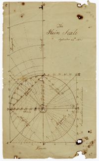
A diagram of the "Plain Scale." The horizontal axis is labeled "inclinations of meridians" and vertical axis is labeled hours. Various geometric shapes and lines such as chord, rhombus, tangents, secants, semi tangents, longitudes, and latitudes are drawn within the "plain."
Plat of Hopewell Plantation with surrounding lands owned by several people, shows the Edisto River and an unnamed settlement, labels the land in the center as uncleared land while swamps, roads, rivers and trees surround it. Acreage unclear. Names associated with this plat are Baring, Branford, Mellechamp, Colonel W. Hayne and Arthur Middleton. Notable geographic locations are St. Paul's Parish, Edisto River, and Willtown Road.
"Includes descriptions of towns including: Baltimore MD, Wilmington DE, Albany N.Y., Washington D.C., Raleigh and Fayetteville, N.C. Information is also given on countryside, roads, buildings, bridges, agriculture, and flora. Attention is given to architectural features throughout. Included are occasional sketches and descriptions of estates, including William Hamilton's The Woodlands and the ""Palace of the President"" [White House] (especially the interior), and the Capitol buildings. Drayton travels part-way with Eli Whitney (1765-1825), creator of the cotton gin."
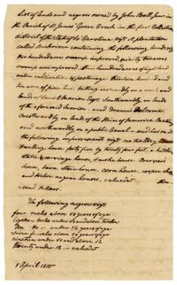
A list of lands and enslaved persons owned by John Ball which includes Back River Plantation, it's swamps, lands for cultivation, pine land, a carriage house, smoke house, overseer's house, store house, corn house, a cooper shop and twelve "negro" houses. The document also lists that there are four enslaved men above fifty years of age, eighteen enslaved men under fifty and above twelve, ten enslaved boys under the age of twelve, seven enslaved women above fifty years old, nineteen enslaved women under fifty and above twelve and twenty enslaved girls under twelve.
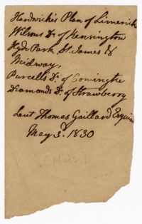
A list of enslaved women confined at Midway Plantation and tools left out by the enslaved person Marcus. The bottom of the document is a balance of tools at Kensington Plantation.
The Edisto Island Presbyterian Church Register is an unbound book recorded between 1837-1901. The register contains minutes from church sessions, baptism and marriage records, church memberships and church controversies with references to enslaved men and women by name and the accusations against them. Also included is the constitution of the Edisto Union Church, which was formed by Africans Americans, formerly enslaved, who took over the Edisto Island Presbyterian Church following the Civil War.
Long humorous letter written by Theodore Drayton Grimke-Drayton from Offenbach, Germany (1840s?) to his mother describing taking a break from his studies, visiting small towns, castle ruins, going fishing and the dangerous prank he undertook scaling a tower in the duchy of Walsaw, the village of Falkenstein.
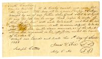
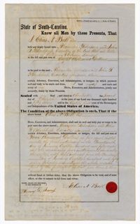
A bond from Elias Ball to executors of William Carson's estate Alexander Robertson and John Blacklock for $8,000. The document includes records of paid installments.
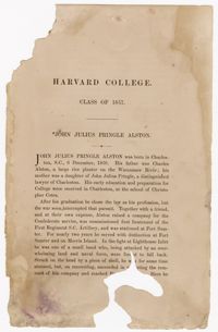
A brief biography describing John Julius Alston's upbringing, education, time in the Confederate military, and ultimate death. This section is part of a larger report on graduates of Harvard College from the class of 1857.
An agreement regarding six enslaved persons bequeathed to Henry Hilliard Gooch's children. The names of the enslaved persons are Melisy, William, Amelia, Miles, Dave and John.
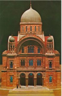
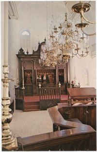
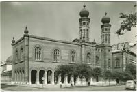
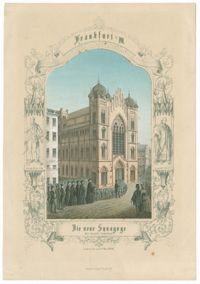
Hand-colored lithograph of the exterior of the Hauptsynagogue (Main Synagogue) in the Börnestrasse in Frankfurt am Main. Published Frankfurt am Main: Lith. Inst. v. Ph. Frey & Co.
A receipt for thirteen bushels of rice from William Ball. The receipt includes a mark, most likely in place of a signature from an enslaved or freed person.
Postcard with a reproduction of a painted portrait by Franz Rederer of Hebert Samuel, High Commissioner of Palestine. The original oil painting is held at the National Portrait Gallery.
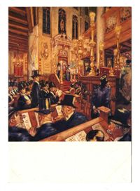
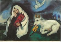
Postcard with a reproduction of Martin Monnickendam's painting of a synagogue service commemorating the 300th anniversary of the Ashkenazic Community of Amsterdam.
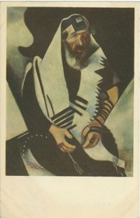
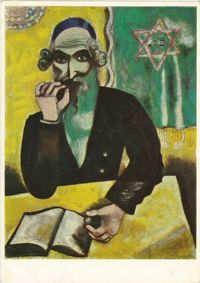
Postcard with a reproduction of the oil painting The Praying Jew (Rabbi of Vitebsk) by Marc Chagall. The original painting is held in the Joseph Winterbotham Collection at the Art Institute of Chicago.
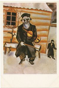
Postcard with a reproduction of the oil painting Violinist on a Bench by Marc Chagall. The original painting is held at the Los Angeles County Museum of Art.
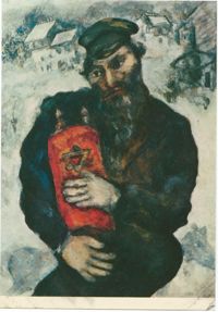
Postcard with a reproduction of the oil painting Rabbi, The Pinch of Snuff by Marc Chagall. The original painting is held by the Öffentliche Kunstsammlung Basel.
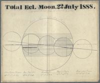
In this astronomical chart (front and back) Gibbes provides a diagram of the phases of the eclipse and the circle of the Earth's shadow when the moon enters the shadow, eclipse begins, middle of eclipse, end of eclipse and the moon leaving the shadow. On the back of the page Gibbes provides the elements for constructing the diagram. Those elements are hourly motion, declination, hourly motion in declination, horizontal parallax and semidiameter. Gibbes also provides the time of the aforementioned phases.
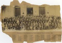
Black-and-white photograph, mounted on card, of a portrait of a large group of men, each one with a number written on or near them. Text under the image reads, "Members of the Constitutional Convention of South Carolina, 1895." The numbers near each man coordinate with a list of names below the title of the photograph.


![Letter to Thomas Drayton from his nephew Glen Drayton, April 20, [1801?]](https://iiif.library.cofc.edu/iiif/2/40389/full/200,/0/default.jpg)


![Letter from Theodore Drayton-Grimke from Offenbach, Germany, 1840s[?]](https://iiif.library.cofc.edu/iiif/2/24242/full/200,/0/default.jpg)
![187. Note - Nov. 8, [?]](https://iiif.library.cofc.edu/iiif/2/25400/full/200,/0/default.jpg)