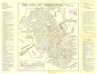
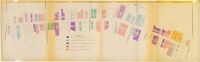
Map of the Charleston peninsula with historic points of interest identified and noted. Includes a welcome to visitors by Mayor Burnet R. Maybank and a map of "The Garden Club Walk" route. "Released by the Office of Port Development." Measures 16" x 22".
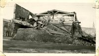
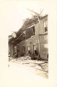
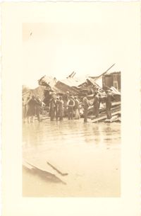
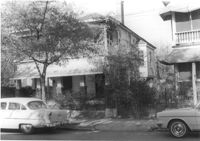
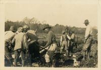
Photograph of wooden building demolished by the first tornado of September 29, 1938. The photograph is marked with a small green X to show the location of the body of a man killed by the tornado. Handwritten on back of photo: "1st tornado came in by Battery near Miller's junk yard - Laurence [Laurens?] Street. This shed is on top of small Negro house. The Negro was dead when found. Sept. 29, '38."
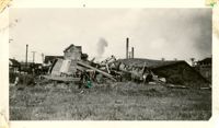
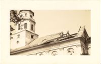
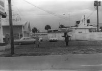
Photograph of the Viohl Hay & Grain warehouse demolished by the tornado of September 29, 1938. Located at the northwest corner of Vendue Range and Concord Street (address 14 Vendue Range). Portion of the building across the street can be seen at left. Steeple of St. Michael's Church in the distance at right. Handwritten on back of photo: "Taken in front of the Clyde Line Steam Ship Co. on Concord Street. Vohls Grain Place. Tornado - Sept. 29, 1938. In distance is St. Michael's Church steeple."
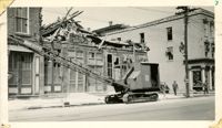
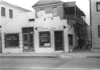
Photograph of the I.M. Pearlstine Building (203 East Bay Street), located on the southwest corner of East Bay Street and Street, after the tornado of September 29, 1938, showing the damage done to the building. Also shows 205 East Bay Street, located on the northwest corner of East Bay and Cumberland. "Bay City" heavy equipment vehicle (excavator?) parked in front of building. Pedestrian and a street worker walking on the sidewalk; repairman on the utility pole on the street corner.
Photograph of the I.M. Pearlstine Building on Cumberland Street, located between East Bay and State Street, after the tornadoes of September 29, 1938, showing the damage done to the building. Portion of signage is visible at the right of the photograph, "I.M." and "Budwe[iser]"; signage for "Rex" is also on building (at left). Onlookers stand among the debris on the street.
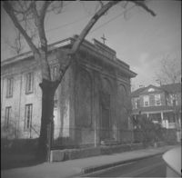
Photograph of First Scots Presbyterian Church [57 Meeting Street] after the tornadoes of September 29, 1938, showing the damage done to the building. The Nathaniel Russell House can be seen in the background. Cars are parked on the street in front of the church.
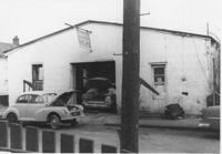
Lot and building (Basha's Garage) on site affected by the widening of U.S. Route 17. Posted signs for Basha's Garage. Presumably located in Mount Pleasant or vicinity. Surveyor notations on back of photo: "Dkt.: 10.439. Property owner: Ernest P. Basha, et al. Tract: 22-A. Station: 246+94 Lt. Date: Jul. 22, 1965. Proximity." [See collection description for explanation of surveyor notations.]
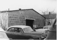
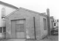
Garage or shed on site affected by the construction of Interstate 26 (I-26). Surveyor notations on back of photo: "Dkt.: 10.480. Property owner: Charles E. Brewer. Tract: 235. Station: 5699+00 Lt. Date: May 31, 1961. In R/W - Bought." [See collection description for explanation of surveyor notations.]
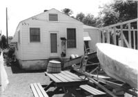
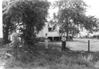
House (rear view) on site affected by the construction of Interstate 26 (I-26). Wood framing for another structure under construction and a motorboat and picnic table in photograph. Surveyor notations on back of photo: "Dkt.: 10.480. Property owner: James D. Smith. Tract: 233. Station: 5697+90 Lt. Date: May 31, 1961. Proximity." [See collection description for explanation of surveyor notations.]
Multi-family housing on Pickens Street (308 Pickens Street), on site affected by the construction of Interstate 26 (I-26). Surveyor notations on back of photo: "Dkt.: 10.490. Property owner: Ashley Development Co. Tract: 1-A. Station: 5769+75 to 5771+25 Lt. Date: September 11, 1962. In R/W - Bought." [See collection description for explanation of surveyor notations.]
Multi-family housing on Pickens Street (310 Pickens Street), on site affected by the construction of Interstate 26 (I-26). Surveyor notations on back of photo: "Dkt.: 10.490. Property owner: Ashley Development Co. Tract: 1-A. Station: 5769+35 to 5771+00 on CL. Date: September 11, 1962. In R/W - Bought." [See collection description for explanation of surveyor notations.]
House on site affected by the construction of Interstate 26 (I-26). Address: 68 Fishburne Street. Surveyor notations on back of photo: "Dkt.: 10.517. Property owner: Annie F. Moessner. Tract: 117. Station: 26+55 Lt. Southbound Lane Route 17. Date: March 5, 1963. Proximity." [See collection description for explanation of surveyor notations.]
House (corner view, rear) on site affected by the construction of Interstate 26 (I-26). Surveyor notations on back of photo: "Dkt.: 10.480. Property owner: H.L. DuPuis Sr. Tract: 274. Station: 5725+90 Rt. (Line C). Date: May 31, 1961. In R/W - Bought." [See collection description for explanation of surveyor notations.]
House (rear view) on site affected by the construction of Interstate 26 (I-26). Surveyor notations on back of photo: "Dkt.: 10.480. Property owner: William R. Hankins. Tract: 275. Station: 5726+40 Rt. (Line C). Date: May 31, 1961. In R/W - Bought." [See collection description for explanation of surveyor notations.]
House (rear view) and yard, on site affected by the construction of Interstate 26 (I-26). Surveyor notations on back of photo: "Dkt.: 10.480. Property owner: Mrs. Lila Hutto. Tract: 280. Station: 5729+00 Lt. (Line C). Date: May 31, 1961. Proximity." [See collection description for explanation of surveyor notations.]
House (rear view) on site affected by the construction of Interstate 26 (I-26). Surveyor notations on back of photo: "Dkt.: 10.480. Property owner: C.G. Hudson. Tract: 251. Station: 5706+70 Lt. Date: May 31, 1961. In R/W - Bought." [See collection description for explanation of surveyor notations.]
Side of building on site affected by the construction of the Crosstown. Address: 186 Spring Street. (See following two photographs.) Lot across the street in foreground. Surveyor notations on back of photo: "Dkt.: 10.524. Property owner: Mona G. Sokol. Tract: 25. Station: 65+60 CL Lt. Date: Oct. 13, 1964. In R/W - Bought." [See collection description for explanation of surveyor notations.]
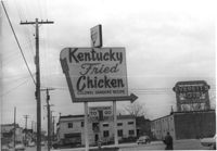
Lot and Kentucky Fried Chicken, on site affected by the construction of the Crosstown. Address: 223 Spring Street. Patio [restaurant?] in background. Surveyor notations on back of photo: "Dkt.: 10.524. Property owner: Arco Investment Co. Tract: 160 and 161. Station: 17±50 Rt. Spring Street. Date: Dec. 2, 1964." [See collection description for explanation of surveyor notations.]
Sign for Kentucky Fried Chicken, on site affected by the construction of the Crosstown. Address: 223 Spring Street. Everett's Motel in background. Surveyor notations on back of photo: "Dkt.: 10.524. Property owner: Arco Investment Co. Tract: 160 and 161. Station: 17±50 Rt. Spring Street. Date: Dec. 2, 1964." [See collection description for explanation of surveyor notations.]
Partial view of The Fork (restaurant) and lot on site affected by the construction of the Crosstown. Address: 223 Spring Street. James Hotel [Hotel James] in background. Surveyor notations on back of photo: "Dkt.: 10.524. Property owner: The Fork Co. Inc. Tract: 156. Station: 13±00 Rt. Spring Street. Date: Dec. 2, 1964." [See collection description for explanation of surveyor notations.]
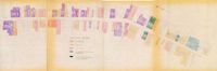
One of four maps of King Street building footprints, hand-colored to designate status. This map illustrates proposed reuses of buildings on King Street from Calhoun Street to Queen Street.
One of four maps of King Street building footprints, hand-colored to designate status. This map illustrates the historical significance of buildings on King Street from Calhoun Street to Queen Street.
Looking north on Church Street from Chalmers Street. Features buildings on the west side of the street: 127 Church, 129 Church, 131 Church, and the Dock Street Theater). Also in view are buildings on the east side of the street: 18 Chalmers Street, 132 Church Street, and St. Philip's Church). Cars are parked on the street.
Wood-sided building on site affected by the construction of Interstate 26 (I-26). Building address number 4804. Neon sign for a Drive In (__MANER'S) (name partly illegible) in front. Billboard for First National Homes (4800 Rivers Ave.) next to building. Possibly on Rivers Avenue. Surveyor notations on back of photo: "Dkt.: 10.486. Property owner: Redding F. Moore. Tract: 23, 24, 25. Station: 15+50 Rt. (Line C). Date: May 30, 1961. In R/W - Bought." [See collection description for explanation of surveyor notations.]
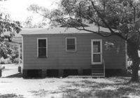
House (rear view) on site affected by the construction of Interstate 26 (I-26). Address: 2128 Montford Avenue. Surveyor notations on back of photo: "Dkt.: 10.490. Property owner: Chas. W. Jenkins, Jr. [Charles W. Jenkins, Jr.]. Tract: 174. Station: 35' Lt. Sta. 5884+60. Date: May 15, 1962. In R/W - Bought." [See collection description for explanation of surveyor notations.]
House (rear view) on site affected by the construction of Interstate 26 (I-26). Address: 2126 Montford Avenue. Surveyor notations on back of photo: "Dkt.: 10.490. Property owner: Emory Hendrix, et al. Tract: 175. Station: 5884+80 Lt. Date: August 29, 1962. In R/W - Bought." [See collection description for explanation of surveyor notations.]
House on site affected by the construction of the Crosstown. Address: 57 Lee Street. Surveyor notations on back of photo: "Dkt.: 10.518. Property owner: Augustus G. Purvis. Tract: 49. Station: 45+05 Lt. N.B. lane Route 17. Date: Mar. 6, 1963. In R/W - Bought." [See collection description for explanation of surveyor notations.]
House on site affected by the construction of the Crosstown. Address: 55 Lee Street. Surveyor notations on back of photo: "Dkt.: 10.518. Property owner: Augustus G. Purvis. Tract: 49. Station: 45+55 Lt. N.B. lane Route 17. Date: Mar. 6, 1963. In R/W - Bought." [See collection description for explanation of surveyor notations.]
Rear view of house on site affected by the construction of the Crosstown. Address: 508 Rutledge Avenue. Surveyor notations on back of photo: "Dkt.: 10.524. Property owner: W.C. Hayes, Est. Tract: 112. Station: 86+60 Lt. Date: Dec. 1, 1964. In R/W - Bought." [See collection description for explanation of surveyor notations.]
House on site affected by the construction of the Crosstown. Address: 504 Rutledge Avenue. Surveyor notations on back of photo: "Dkt.: 10.524. Property owner: Florence Britton Jones. Tract: 114. Station: 86+30 Rt. Date: Dec. 1, 1964. In R/W - Bought." [See collection description for explanation of surveyor notations.]
House on site affected by the construction of the Crosstown. Address: 504 Rutledge Avenue. Surveyor notations on back of photo: "Dkt.: 10.524. Property owner: Florence Britton Jones. Tract: 114. Station: 86+30 Rt. Date: Dec. 1, 1964. In R/W - Bought." [See collection description for explanation of surveyor notations.]
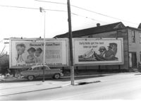
Lot with billboards on site affected by the construction of the Crosstown. Address: 53 Lee Street. Surveyor notations on back of photo: "Dkt.: 10.518. Property owner: Turner Advertising Co. Tract: 50. Station: 46+00 Rt. N.B. lane Route 17. Date: Mar. 6, 1963. In R/W." [See collection description for explanation of surveyor notations.]
Rear view of house (freedman's cottage) on site affected by the construction of the Crosstown. Address: 7 Rosemont Street. Surveyor notations on back of photo: "Dkt.: 10.524. Property owner: Lauretta Izzard. Tract: 52. Station: 72+70 Rt. Date: Oct. 14, 1964. In R/W - Bought." [See collection description for explanation of surveyor notations.]
House on site affected by the construction of the Crosstown. Address: 16 Todd Street. View of street corner (corner of Todd Street and Sheppard Street). Surveyor notations on back of photo: "Dkt.: 10.524. Property owner: Wilmot J. Frasier. Tract: 125. Station: 88+80 Lt. Date: Dec. 2, 1964. In R/W - Bought." [See collection description for explanation of surveyor notations.]
House on site affected by the construction of the Crosstown. Address: 120 Sheppard Street. View of street corner. Surveyor notations on back of photo: "Dkt.: 10.524. Property owner: Jackson T. Rhodes. Tract: 142. Station: 18+25 Lt. S.B. lane. Date: Dec. 2, 1964. Condemned." [See collection description for explanation of surveyor notations.]
House on site affected by the construction of the Crosstown. Address: 506 Rutledge Avenue. Surveyor notations on back of photo: "Dkt.: 10.524. Property owner: Stephen B. Graham, et al. Tract: 113. Station: 86+50 Lt. Date: Dec. 1, 1964. In R/W - Bought." [See collection description for explanation of surveyor notations.]
House on site affected by the construction of the Crosstown. Address: 120 Sheppard Street. Surveyor notations on back of photo: "Dkt.: 10.524. Property owner: Jackson T. Rhodes. Tract: 142. Station: 18+25 Lt. S.B. lane. Date: Dec. 2, 1964. Condemned." [See collection description for explanation of surveyor notations.]
House on site affected by the construction of the Crosstown. Address: 128 Sheppard Street. Surveyor notations on back of photo: "Dkt.: 10.524. Property owner: Kawarsuan, Inc. Tract: 133. Station: 16+40 Lt. S.B. lane. Date: Dec. 2, 1964. Condemned." [See collection description for explanation of surveyor notations.]
House on site affected by the construction of the Crosstown. Address: 130 Sheppard Street. Surveyor notations on back of photo: "Dkt.: 10.524. Property owner: Charles J. Brendt. Tract: 132. Station: 91+90 Lt. Date: Dec. 2, 1964. In R/W - Bought." [See collection description for explanation of surveyor notations.]
House on site affected by the construction of the Crosstown. Address: 127 Sheppard Street. Surveyor notations on back of photo: "Dkt.: 10.524. Property owner: Essie W. Jenkins. Tract: 129. Station: 91+50 Rt. Date: Dec. 2, 1964. In R/W - Bought." [See collection description for explanation of surveyor notations.]
House on site affected by the construction of the Crosstown. Address: 130 Sheppard Street. Surveyor notations on back of photo: "Dkt.: 10.524. Property owner: Charles J. Brendt. Tract: 132. Station: 91+90 Lt. Date: Dec. 2, 1964. In R/W - Bought." [See collection description for explanation of surveyor notations.]
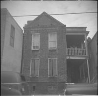
Bush's Auto Repair Shop on site affected by the construction of Interstate 26 (I-26). Address: 44 Sheppard Street. Mechanics working on car in garage bay. Surveyor notations on back of photo: "Dkt.: 10.517. Property owner: S.E. Jenkins. Tract: 71. Station: 5960+15 CL - Line 3. Date: March 5, 1963. In R/W - Bought." [See collection description for explanation of surveyor notations.]
Bush's Auto Repair Shop (rear view) on site affected by the construction of Interstate 26 (I-26). Address: 44 Sheppard Street. Several cars in foreground. Surveyor notations on back of photo: "Dkt.: 10.517. Property owner: S.E. Jenkins. Tract: 71. Station: 5960+15 CL - Line 3. Date: March 5, 1963. In R/W - Bought." [See collection description for explanation of surveyor notations.]
Collins Auto Glass Service (rear view) on site affected by the construction of Interstate 26 (I-26). Address: 91 Lee Street. Surveyor notations on back of photo: "Dkt.: 10.517. Property owner: W.H. Yon. Tract: 56. Station: 34+30 Lt. - Route 17. Date: February 21, 1963." [See collection description for explanation of surveyor notations.]
Lafayette Motors, on site affected by the construction of Interstate 26 (I-26). Address: 680 King Street. Surveyor notations on back of photo: "Dkt.: 10.517. Property owner: Raymond A. Wittschen. Tract: 122. Station: 28+35 Lt. Southbound Lane Route 17. Date: March 5, 1963. Proximity." [See collection description for explanation of surveyor notations.]
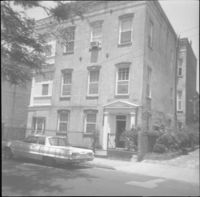
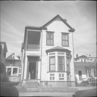
House (corner view, piazza side) on site affected by the construction of Interstate 26 (I-26). Address: 284 Coming Street. Surveyor notations on back of photo: "Dkt.: 10.517. Property owner: M.J. Christine Butt, Est. Tract: 103. Station: 22+40 Rt. Southbound Lane Route 17. Date: March 5, 1963. In R/W - Bought." [See collection description for explanation of surveyor notations.]
House on site affected by the construction of Interstate 26 (I-26). Address: 91 Fishburne Street. View of Street corner; corner of Fishburne Street and Coming Street. Surveyor notations on back of photo: "Dkt.: 10.517. Property owner: Annie E. Stossen. Tract: 105. Station: 22+65 Lt. Southbound Lane Route 17. Date: March 5, 1963. In R/W - Bought." [See collection description for explanation of surveyor notations.]
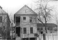
House (corner view, rear) on site affected by the construction of Interstate 26 (I-26). [Building address number 185.] Surveyor notations on back of photo: "Dkt.: 10.480. Property owner: Janet H. & Robert Carl Wilson. Tract: 262. Station: 5713+50 Lt. Date: May 31, 1961. In R/W - Bought." [See collection description for explanation of surveyor notations.]
House (rear view) on site affected by the construction of Interstate 26 (I-26). Address: 83 Sheppard Street. Surveyor notations on back of photo: "Dkt.: 10.517. Property owner: Marguerite Gorman. Tract: 85. Station: 26+65 Lt. Northbound Lane Route 17. Date: March 5, 1963. In R/W - Bought." [See collection description for explanation of surveyor notations.]
House on site affected by the construction of Interstate 26 (I-26). Address: 83 Sheppard Street. Surveyor notations on back of photo: "Dkt.: 10.517. Property owner: Marguerite Gorman. Tract: 85. Station: 26+65 Lt. Northbound Lane Route 17. Date: March 5, 1963. In R/W - Bought." [See collection description for explanation of surveyor notations.]
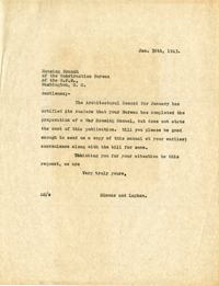
Letter to the Housing Branch of the Construction Bureau of the W.P.B. from Simons and Lapham (Jan. 30, 1943) regarding the price of a War Housing Manual.
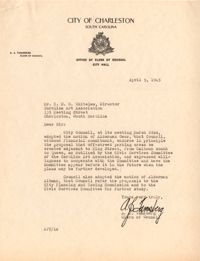
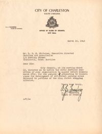
Letter to Robert N.S. Whitelaw from A.J. Tamsberg regarding the Civic Services Committee representatives presenting on off-street parking at a City Council meeting (March 15, 1945).
Letter to Robert N.S. Whitelaw from Henry F. Welch accepting the invitation to South Carolina Society to be represented at an upcoming meeting (Jan. 26, 1937).
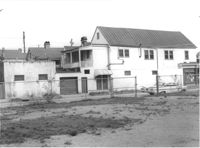
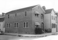
Building (corner view, front) on site affected by the construction of the Crosstown. Address: 120 Drake Street (based on buildings across the street). Sign in front: Harrisson & Co. Fishing Tacking Hardware. Elevated roadway (presumably the off-ramp of the Grace Memorial Bridge) in background. Surveyor notations on back of photo: "Dkt.: 10.518. Property owner: Frank J. Kelly. Tract: 78. Station: 55+60 Rt. N.B. lane Route 17. Date: Mar. 7, 1963." [See collection description for explanation of surveyor notations.]
Building, on site affected by the construction of the Crosstown. Address: 209 Spring Street. Friendly Barber Shop and Spot Light Radio TV Service. Front facade has stepped parapet. Surveyor notations on back of photo: "Dkt.: 10.524. Property owner: Maybell Fields. Tract: 166. Station: 20+00 Rt. Spring Street. Date: Dec. 2, 1964." [See collection description for explanation of surveyor notations.]
Building, on site affected by the construction of the Crosstown. Address: 207 Spring Street. Sew-U-Save Shop. Surveyor notations on back of photo: "Dkt.: 10.524. Property owner: Olympia Papaeilidow. Tract: 167. Station: 20+35 Rt. Spring Street. Date: Dec. 2, 1964." [See collection description for explanation of surveyor notations.]
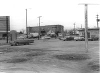
Shell gas station (rear view) on site affected by the construction of the Crosstown. Address: 233 Spring Street. Surveyor notations on back of photo: "Dkt.: 10.524. Property owner: Shell Oil Co. Tract: 155. Station: 9+00 Rt. Spring Street. Date: Dec. 2, 1965." [See collection description for explanation of surveyor notations.]
Hardee's, on site affected by the construction of the Crosstown. Address: 223 Spring Street. Surveyor notations on back of photo: "Dkt.: 10.524. Property owner: Sarah Chinnis Sanders. Tract: 157. Station: 14+60 Rt. Spring Street. Date: Dec. 2, 1964." [See collection description for explanation of surveyor notations.]
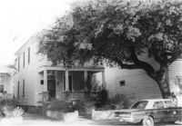
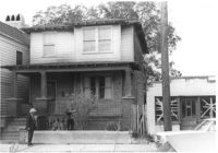
House on site affected by the construction of the Crosstown. Address: 114 Bogard Street. Surveyor notations on back of photo: "Dkt.: 10.524. Property owner: Francis Jenkins, et al. Tract: 64. Station: 75+70 CL Rt. Date: Oct. 14, 1964. In R/W - Bought." [See collection description for explanation of surveyor notations.]
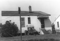
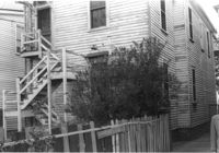
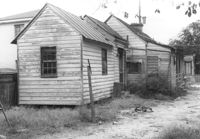
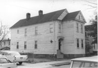
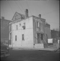
House (corner view) on site affected by the construction of Interstate 26 (I-26). Garage/shed at end of driveway. Surveyor notations on back of photo: "Dkt.: 10.480. Property owner: R.R. Barwick. Tract: 137. Station: 5655+80 Rt. Date: May 2, 1961. In R/W - Bought." [See collection description for explanation of surveyor notations.]
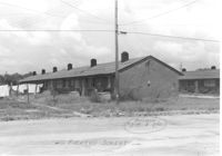
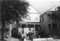
House on site affected by the construction of Interstate 26 (I-26). Address: 11 Brigade Street. Surveyor notations on back of photo: "Dkt.: 10.503. Property owner: Ada Williams. Tract: 42. Station: 5905+20 Rt. Date: Feb. 19, 1963. In R/W - Bought." [See collection description for explanation of surveyor notations.]
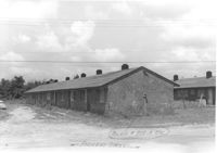
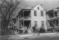
Row of houses on site affected by the construction of Interstate 26 (I-26). Address: 20-32 Brigade Street. Surveyor notations on back of photo: "Dkt.: 10.503. Property owner: Gussie Feldman. Tract: 41. Station: 5904+30 Rt. In R/W - Bought." [See collection description for explanation of surveyor notations.]
Statement of Mr. Aldace F. Walker, Vice-President of Trans-American Pipeline Corporation describing the functions of the Trans-American Pipeline Corporation (delivered to the Community Development Council).
House on site affected by the construction of the Crosstown. Address: 190 Spring Street. Surveyor notations on back of photo: "Dkt.: 10.524. Property owner: E.H. Heidman, Est. Tract: 18. Station: 24± Lt. (Spring Street). Date: Oct. 13, 1964. Portion in R/W to be removed." [See collection description for explanation of surveyor notations.]
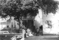
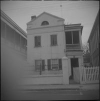
House on site affected by the construction of the Crosstown. Address: 22 Wescott Street. Surveyor notations on back of photo: "Dkt.: 10.524. Property owner: Ida J. Gantt. Tract: 10. Station: 61+20 Lt. Date: Oct. 13, 1964." [See collection description for explanation of surveyor notations.]
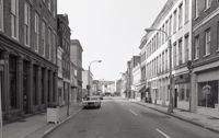
Black-and-white photograph of the view north on King Street showing the east side of King Street from 190 King Street (right) and 191 King Street (left). Kerrison's building in the background.
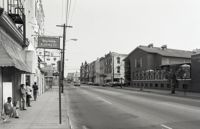
Black-and-white photograph of the view south on Meeting Street from 242 Meeting, showing Anderson Electric Co. (246 Meeting) at right and the Best Western King Charles Hotel (237 Meeting) at left.