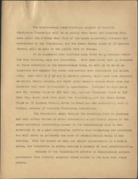
This three-page typed informational introduction and outline provides an overview of historic buildings in Charleston, effects of industrialization on the city, and encourages readers to donate to the Historic Charleston Foundation's Revolving Fund. The outline details goals for use of Revolving Fund monies.
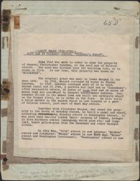
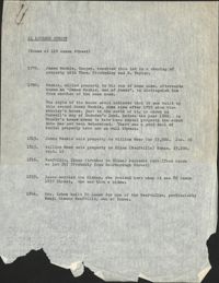
This one-page typed document provides information regarding the property at the East end of Calhoun Street, known as Gadsden's Wharf. The land ownership is traced back to 1696 under Issac Mazyck. Land development beginning in 1746 under Captain George Anson is also discussed, including the construction of a canal and wharf in Charleston. Changes in street names since the city's early days are also mentioned.
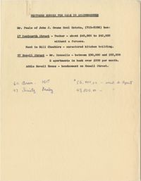
In this one-page typed document eight houses and gardens are added to the walking tour through the Ansonborough Neighborhood: 19 Wentworth Street, 57 Anson Street, 46 Society Street,43 Society Street, 63 Anson Street, 75 Anson Street, and 79 Anson Street. An approximate date of when the buildings on the property were built, as well as ownership information, is included.
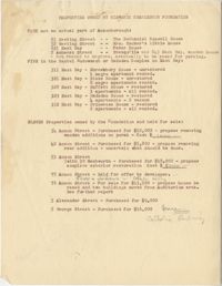
This four-page typed document provides ownership information for properties of interest to Historic Charleston Foundation. Specific categories for properties include spaces outside the Ansonborough neighborhood, in the rental endowment or Gadsden Complex, properties held for sale, properties in the process of being sold to Historic Charleston Foundation, properties being considered for purchase, properties near an area designated as the Auditorium Fringe, properties on Alexander Street, and properties on George Street.
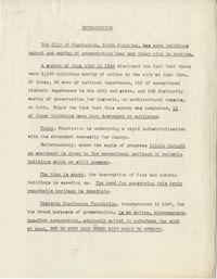
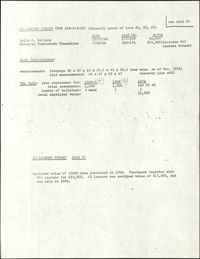
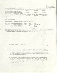
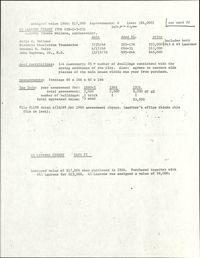
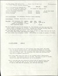
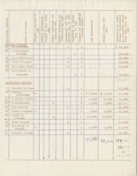
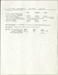
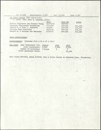
This three-page typed document includes a table providing information for numerous Ansonborough properties. The properties are organized by street, which include Hasell Street, Wentworth Street, Society Street, Laurens Street, Anson Street, and George Street. Informational categories include ownership, Historic Charleston Foundation's involvement with the property, number of improved living units at the property, and financial investments in the property.
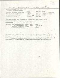
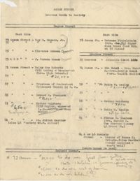
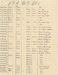
In this two-sided typed document, numerous properties and their owners are listed. Properties are organized by street in the Ansonborough neighborhood. This document also includes notes on front and back regarding specific renovations and costs associated with the properties.
Provided on the front of this two-sided typed document is information regarding the property at the East end of Calhoun Street, known as Gadsden's Wharf. The land ownership is traced back to 1696 under Issac Mazyck. Land development beginning in 1746 under Captain George Anson is also discussed, including the construction of a canal and wharf in Charleston. Changes in street names since the city's early days are also mentioned. A small piece of paper taped to the back reads: "Kindness of: Mr. Gedney M. Howe."
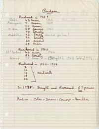
This one-page handwritten document lists numerous properties in the Ansonborough neighborhood on Anson Street, Laurens Street, Society Street, Wentworth Street, and East Bay Street. Informational headings for properties include: date acquired, date sold, purchase price, Foundation Improvements, selling price, purchaser's improvements, and owner.
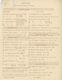
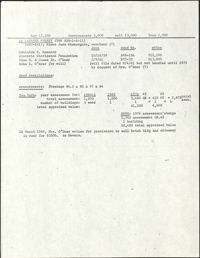
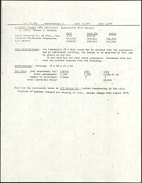
This five-page handwritten document contains information about properties in Ansonborough, including address, owner, kind of building, dimensions, and 1960 assessment.
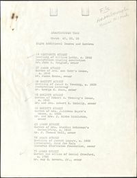
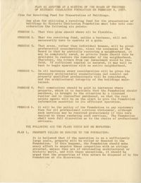
This three-page typed document details the use of monies in the Historic Charleston Foundation Revolving Fund, stipulated by six points written by the Foundation. Six plans for purchase of properties are also included.
This two-page typed document describes a tour of Ansonborough Rehabilitation Project houses, including: 55 Laurens Street, the James Jervey House; 44 Society Street; 42 Society Street; 329 East Bay Street, the Gadsden House; and 332 East Bay Street, the Primerose House. Also includes information about other houses sold in Ansonborough, including 43 Society Street and houses on Laurens and Wentworth Streets.
This three-page typed document describes a tour of Ansonborough Rehabilitation Project houses, including: 42 Society Street; 44 Society Street; 329 East Bay Street, the Gadsden House; 332 East Bay Street, the Primerose House; and 55 Laurens Street, the James Jervey House. Includes information about the Ansonborough Rehabilitation Project committee and its members.
In this two-page typed document, the ownership history of 72 Anson Street is traced back to 1696, under Isaac Mazyck. Subsequent property grants are also discussed, ending in 1901 with the sale of the property to Charles G. Leslie.
In this one-page typed document, Historic Charleston Foundation Director Mrs. S. Henry Edmunds provides a thorough description of 75 Anson Street, The Joseph Legare House, and the accompanying outbuildings, all of which were for sale at the time. Recommended renovations for the property and buildings are included.
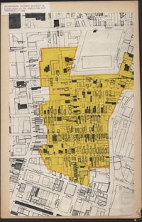
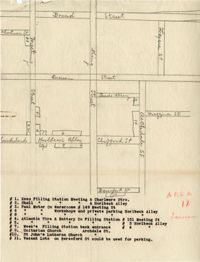
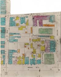
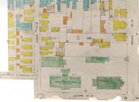
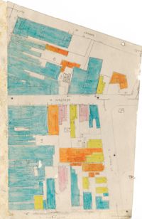
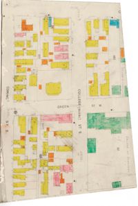
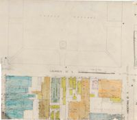
Map of Ansonborough showing Meeting Street, King Street, Hasell Street, Maiden Street, Old Church Street, Bay Street, and others. A small piece of paper taped to the back reads: "Kindness of: Mr. Gedney M. Howe."
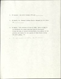
One-page typed document including historical and architectural information for 50 Laurens Street; 48 Hasell Street, St. Johannes Lutheran Church; and 54 Hasell Street, former home of Colonel William Rhett. St. Katharine's Convent is written in as the fourth property with no accompanying information.
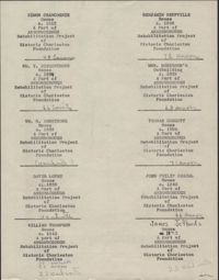
In this two-page typed document,the owners and plot numbers for numerous properties are listed. Properties are listed by street in the Ansonborough neighborhood.
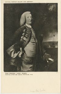
A post card printed for the National Portrait Gallery in London. On the front is a portrait of George, First Lord Anson (1697-1762); on the back is a brief biography of Anson by Philip Gosse.