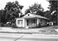
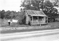
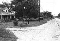
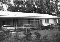
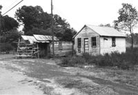
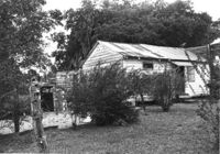
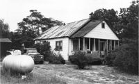
House on site affected by the widening of U.S. Route 17. Presumably located in Mount Pleasant or vicinity. Surveyor notations on back of photo: "Dkt.: 10.597. Property owner: Julia B. Simmons. Tract: 54. Station: 301+00 Lt. Date: Sept. 17, 1968." [See collection description for explanation of surveyor notations.]
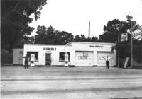
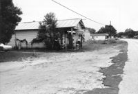
Humble gas station / Esso gas station on site affected by the widening of U.S. Route 17. Ed Cummings, proprietor. Presumably located in Mount Pleasant or vicinity. Surveyor notations on back of photo: "Dkt.: 10.597. Property owner: Edward Cummings. Tract: 37. Station: 285+20 Lt. Date: Sept. 17, 1968." [See collection description for explanation of surveyor notations.]
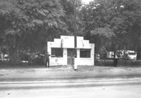
Building on site affected by the widening of U.S. Route 17. Front facade has stepped parapet. Appears to have previously been a business. Presumably located in Mount Pleasant or vicinity. Surveyor notations on back of photo: "Dkt.: 10.597. Property owner: Leon Burns, et al. Tract: 5. Station: 265± Lt. looking south. Date: Sept. 17, 1968." [See collection description for explanation of surveyor notations.]
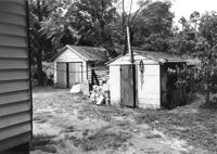
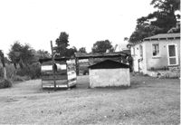
Sheds behind house on site affected by the widening of U.S. Route 17. Presumably located in Mount Pleasant or vicinity. Surveyor notations on back of photo: "Dkt.: 10.597. Property owner: Julia B. Simmons. Tract: 54. Station: 301±30 Lt. Date: Sept. 17, 1968." [See collection description for explanation of surveyor notations.]
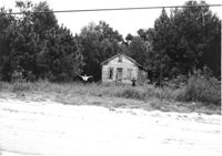
House in dilapidated condition on site affected by the widening of U.S. Route 17. Presumably located in Mount Pleasant or vicinity. Surveyor notations on back of photo: "Dkt.: 10.597. Property owner: Isaac Snype, Estate. Tract: 39. Station: 288+10 Lt. Date: Sept. 17, 1968." [See collection description for explanation of surveyor notations.]
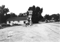
Phillips 66 gas station on site affected by the widening of U.S. Route 17. Gulf gas station in background. Presumably located in southern Charleston County. Surveyor notations on back of photo: "Dkt.: 10.600. Property owner: Nora Bishop Carmichael. Tract: 18. Station: 608±40 Lt. Date: Sept. 18, 1968." [See collection description for explanation of surveyor notations.]
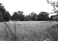
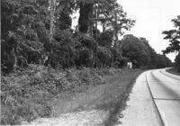
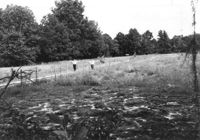
Lot on site affected by the widening of U.S. Route 17. Presumably located in southern Charleston County. Surveyor notations on back of photo: "Dkt.: 10.600. Property owner: John D. Postell, Sr., Estate. Tract: 12. Station: 605± Rt. Date: Sept. 18, 1968." [See collection description for explanation of surveyor notations.]
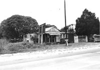
Building on site affected by the widening of U.S. Route 17. Appears to have previously been a store. Presumably located in Mount Pleasant or vicinity. Surveyor notations on back of photo: "Dkt.: 10.597. Property owner: Geo. G. Browder, Jr. Tract: 22. Station: 275+20 Lt. Date: Sept. 17, 1968." [See collection description for explanation of surveyor notations.]
House and lot on site affected by the widening of U.S. Route 17. Small roadside stand on property. Presumably located in Mount Pleasant or vicinity. Surveyor notations on back of photo: "Dkt.: 10.597. Property owner: Dorothy R. Ayers, et al. Tract: 12-A213. Station: 259+50Rt. looking north. Date: Sept. 17, 1968." [See collection description for explanation of surveyor notations.]
Buildings on site affected by the widening of U.S. Route 17. Wagon Wheel Furniture in foreground. Presumably located in Mount Pleasant or vicinity. Surveyor notations on back of photo: "Dkt.: 10.597. Property owner: Erma B. Salvo. Tract: 18. Station: 268± Lt. Date: Sept. 17, 1968." [See collection description for explanation of surveyor notations.]
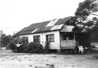
House in dilapidated condition and sweetgrass basket stand on site affected by the widening of U.S. Route 17. Presumably located in Mount Pleasant or vicinity. Surveyor notations on back of photo: "Dkt.: 10.597. Property owner: Linda Huger, Estate. Tract: 84 & 85. Station: 448± Lt. Date: Sept. 17, 1968." [See collection description for explanation of surveyor notations.]
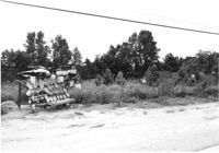
Lot with sweetgrass basket stand, on site affected by the widening of U.S. Route 17. Presumably located in Mount Pleasant or vicinity. Surveyor notations on back of photo: "Dkt.: 10.597. Property owner: Mary B. McConnell. Tract: 81. Station: 440±30 Rt. Date: Sept. 17, 1968." [See collection description for explanation of surveyor notations.]
Rear view of house and sheds on site affected by the widening of U.S. Route 17. Presumably located in Mount Pleasant or vicinity. Surveyor notations on back of photo: "Dkt.: 10.597. Property owner: John Gailliard. Tract: 102. Station: 466±40 Rt. Date: Sept. 17, 1968." [See collection description for explanation of surveyor notations.]
House (corner view, rear) on site affected by the widening of U.S. Route 17. Presumably located in Mount Pleasant or vicinity. Surveyor notations on back of photo: "Dkt.: 10.597. Property owner: John Gailliard. Tract: 102. Station: 466±40 Rt. Date: Sept. 17, 1968." [See collection description for explanation of surveyor notations.]
House (corner view, rear) on site affected by the widening of U.S. Route 17. Presumably located in Mount Pleasant or vicinity. Surveyor notations on back of photo: "Dkt.: 10.597. Property owner: Charles Dingle. Tract: 98. Station 462±50 Rt. Date: Sept. 17, 1968." [See collection description for explanation of surveyor notations.]
House (rear view) on site affected by the widening of U.S. Route 17. Presumably located in Mount Pleasant or vicinity. Surveyor notations on back of photo: "Dkt.: 10.597. Property owner: George Frederick, Estate. Tract: 91. Station: 456±20 Rt. Date: Sept. 17, 1968." [See collection description for explanation of surveyor notations.]
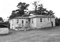
House on site affected by the widening of U.S. Route 17. Presumably located in Mount Pleasant or vicinity. Surveyor notations on back of photo: "Dkt.: 10.597. Property owner: Prince and Wilhelmina Gilliard. Tract: 92. Station: 457±10 Rt. Date: Sept. 17, 1968." [See collection description for explanation of surveyor notations.]
House (rear view) on site affected by the widening of U.S. Route 17. Presumably located in Mount Pleasant or vicinity. Surveyor notations on back of photo: "Dkt.: 10.597. Property owner: Irene Foreman. Tract: 78. Station: 441+50 Lt. Date: Sept. 17, 1968." [See collection description for explanation of surveyor notations.]
House on site affected by the widening of U.S. Route 17. Presumably located in Mount Pleasant or vicinity. Surveyor notations on back of photo: "Dkt.: 10.597. Property owner: George Frederick, Estate. Tract: 91. Station: 456±20 Rt. Date: Sept. 17, 1968." [See collection description for explanation of surveyor notations.]
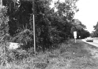
Lot on site affected by the widening of U.S. Route 17. Presumably located in Mount Pleasant or vicinity. Surveyor notations on back of photo: "Dkt.: 10.597. Property owner: Alexandera E. Stone, Est. Tract: 55. Station: 302± Lt. looking east. Date: Sept. 17, 1968." [See collection description for explanation of surveyor notations.]
The Twin Lanterns Antiques, Gifts, Used Furniture shop, on site affected by the widening of U.S. Route 17. Neighboring fireworks store in background. Presumably located in Mount Pleasant or vicinity. Surveyor notations on back of photo: "Dkt.: 10.597. Property owner: Oliver H. Smith. Tract: 56. Station: 297+70 Rt. Date: Sept. 17, 1968." [See collection description for explanation of surveyor notations.]
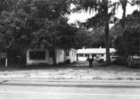
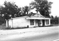
Bargain Center Supermarket on site affected by the widening of U.S. Route 17. Presumably located in southern Charleston County. Surveyor notations on back of photo: "Dkt.: 10.600. Property owner: Vernon A. Ellis. Tract: 3. Station: 512± - 514± Rt. Date: Sept. 18, 1968." [See collection description for explanation of surveyor notations.]
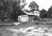
Shed and/or garage on site affected by the widening of U.S. Route 17. Presumably located in southern Charleston County. Surveyor notations on back of photo: "Dkt.: 10.600. Property owner: Vernon A. Ellis. Tract: 3. Station: 512± - 514± Rt. Date: Sept. 18, 1968." [See collection description for explanation of surveyor notations.]
House and sweetgrass basket stand on site affected by the widening of U.S. Route 17. Presumably located in Mount Pleasant or vicinity. Surveyor notations on back of photo: "Dkt.: 10.597. Property owner: Linda Huger, Estate. Tract 84 & 85. Station: 448±70 Lt. Date: Sept. 17, 1968." [See collection description for explanation of surveyor notations.]
House in dilapidated condition and structure on site affected by the widening of U.S. Route 17. Presumably located in Mount Pleasant or vicinity. Surveyor notations on back of photo: "Dkt.: 10.597. Property owner: Charles & Eugene German. Tract: 88. Station: 449±50 Rt. Date: Sept. 17, 1968." [See collection description for explanation of surveyor notations.]
House in dilapidated condition and lot on site affected by the widening of U.S. Route 17. Presumably located in Mount Pleasant or vicinity. Surveyor notations on back of photo: "Dkt.: 10.597. Property owner: Mary B. McConnell. Tract: 82. Station: 442± Rt. Date: Sept. 17, 1968." [See collection description for explanation of surveyor notations.]
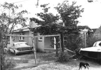
House on site affected by the widening of U.S. Route 17. Presumably located in southern Charleston County. Surveyor notations on back of photo: "Dkt.: 10.600. Property owner: Malsey Lawrence, Estate. Tract: 4. Station: 516±80 Rt. Date: Sept. 18, 1968." [See collection description for explanation of surveyor notations.]
Rear view of house and structure under construction on site affected by the widening of U.S. Route 17. Presumably located in Mount Pleasant or vicinity. Surveyor notations on back of photo: "Dkt.: 10.597. Property owner: James Gailliard. Tract: 101. Station: 465±60 Rt. Date: Sept. 17, 1968." [See collection description for explanation of surveyor notations.]
House (rear view, partially obscured by bushes) on site affected by the widening of U.S. Route 17. Presumably located in Mount Pleasant or vicinity. Surveyor notations on back of photo: "Dkt.: 10.597. Property owner: Charles Dingle. Tract: 98. Station 461±50 Rt. Date: Sept. 17, 1968." [See collection description for explanation of surveyor notations.]
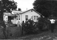
House and lot on site affected by the widening of U.S. Route 17. Wire fence in foreground. Presumably located in Mount Pleasant or vicinity. Surveyor notations on back of photo: "Dkt.: 10.597. Property owner: James Gailliard. Tract: 101. Station: 465±60 Rt. Date: Sept. 17, 1968." [See collection description for explanation of surveyor notations.]
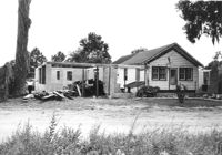
House and structure under construction on site affected by the widening of U.S. Route 17. Presumably located in Mount Pleasant or vicinity. Surveyor notations on back of photo: "Dkt.: 10.597. Property owner: Arthur Gailliard. Tract: 100. Station: 465± Rt. Date: Sept. 17, 1968." [See collection description for explanation of surveyor notations.]
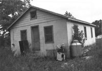
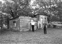
Sheds on site affected by the widening of U.S. Route 17. Presumably located in Mount Pleasant or vicinity. Surveyor notations on back of photo: "Dkt.: 10.597. Property owner: F. Gregorie, Estate. Tract: 93. Station: 460± Rt. Date: Sept. 17, 1968." [See collection description for explanation of surveyor notations.]
House and lot on site affected by the widening of U.S. Route 17. Presumably located in Mount Pleasant or vicinity. Surveyor notations on back of photo: "Dkt.: 10.597. Property owner: Cleveland German. Tract: 89. Station: 450±25 Rt. Date: Sept. 17, 1968." [See collection description for explanation of surveyor notations.]
Lot on site affected by the widening of U.S. Route 17. Presumably located in southern Charleston County. Surveyor notations on back of photo: "Dkt.: 10.600. Property owner: John D. Postell, Jr. Tract: 15. Station: 620± Rt. Date: Sept. 18, 1968." [See collection description for explanation of surveyor notations.]
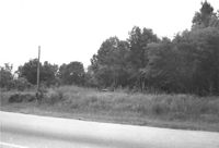
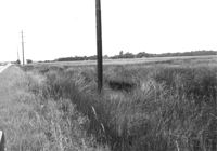
Lot on site affected by the widening of U.S. Route 17. Presumably located in southern Charleston County. Surveyor notations on back of photo: "Dkt.: 10.600. Property owner: Thomas H. Lemacks. Tract: 19. Station: 611± Lt. Date: Sept. 18, 1968." [See collection description for explanation of surveyor notations.]
Lot on site affected by the widening of U.S. Route 17. Presumably located in southern Charleston County. Surveyor notations on back of photo: "Dkt.: 10.600. Property owner: Fred Stewart. Tract: 1-B. Station: 509± Lt. Date: Sept. 18, 1968." [See collection description for explanation of surveyor notations.]
Lot on site affected by the widening of U.S. Route 17. Presumably located in southern Charleston County. Surveyor notations on back of photo: "Dkt.: 10.600. Property owner: Johnnie Ford. Tract: 1-C. Station: 505± Lt. Date: Sept. 18, 1968." [See collection description for explanation of surveyor notations.]
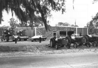
Building on site affected by the widening of U.S. Route 17. Tractors and other machinery on lot. Appears to be a dealer of equipment. Presumably located in southern Charleston County. Surveyor notations on back of photo: "Dkt.: 10.600. Property owner: Arthur J. Stark. Tract: 1. Station: 515± - 520± Lt. Date: Sept. 18, 1968." [See collection description for explanation of surveyor notations.]
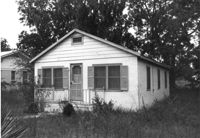
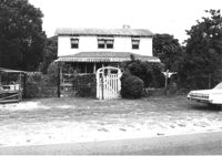
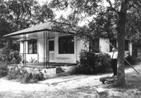
House on site affected by the widening of U.S. Route 17. Presumably located in southern Charleston County. Surveyor notations on back of photo: "Dkt.: 10.600. Property owner: R. Arnold Postell. Tract: 14. Station: 610±35 Rt. Date: Sept. 18, 1968." [See collection description for explanation of surveyor notations.]
Lot on site affected by the widening of U.S. Route 17. Presumably located in southern Charleston County. Surveyor notations on back of photo: "Dkt.: 10.600. Property owner: McLeod Lumber Co. & E.W. Durant. Tract: 9. Station: 585± Rt. Date: Sept. 18, 1968." [See collection description for explanation of surveyor notations.]
Lot on site affected by the widening of U.S. Route 17. Presumably located in southern Charleston County. Surveyor notations on back of photo: "Dkt.: 10.600. Property owner: Lula A. Dickenson, et al. Tract: 5. Station: 525± Lt. & Rt. Date: Sept. 18, 1968." [See collection description for explanation of surveyor notations.]
Lot on site affected by the widening of U.S. Route 17. Presumably located in southern Charleston County. Surveyor notations on back of photo: "Dkt.: 10.600. Property owner: R. Maude P. Postell, Estate. Tract: 13. Station: 613± Lt. Date: Sept. 18, 1968." [See collection description for explanation of surveyor notations.]
Lot on site affected by the widening of U.S. Route 17. Presumably located in southern Charleston County. Surveyor notations on back of photo: "Dkt.: 10.600. Property owner: Dr. T.W. Messervy. Tract: 7. Station: 545± Lt. Date: Sept. 18, 1968." [See collection description for explanation of surveyor notations.]
Lot on site affected by the widening of U.S. Route 17. Presumably located in southern Charleston County. Surveyor notations on back of photo: "Dkt.: 10.600. Property owner: Michah Jenkins. Tract: 6. Station: 546± Rt. Date: Sept. 18, 1968." [See collection description for explanation of surveyor notations.]
House on site affected by the widening of U.S. Route 17. Presumably located in Mount Pleasant or vicinity. Surveyor notations on back of photo: "Dkt.: 10.597. Property owner: George Scott. Tract: 76. Station: 438+50 Lt. Date: Sept. 17, 1968." [See collection description for explanation of surveyor notations.]
House on site affected by the widening of U.S. Route 17. Presumably located in Mount Pleasant or vicinity. Surveyor notations on back of photo: "Dkt.: 10.597. Property owner: Irene Foreman. Tract: 78. Station: 441+50 Lt. Date: Sept. 17, 1968." [See collection description for explanation of surveyor notations.]
House on site affected by the widening of U.S. Route 17. Presumably located in Mount Pleasant or vicinity. Surveyor notations on back of photo: "Dkt.: 10.597. Property owner: George Scott. Tract: 76. Station: 438+50 Lt. Date: Sept. 17, 1968." [See collection description for explanation of surveyor notations.]
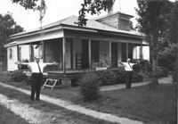
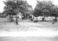
Entry to Boone Hall Plantation, on site affected by the widening of U.S. Route 17. Presumably located in Mount Pleasant or vicinity. Surveyor notations on back of photo: "Dkt.: 10.597. Property owner: Mrs. Nancy T. McRae. Tract: 64. Station: 384±50 Lt. Date: Sept. 17, 1968." [See collection description for explanation of surveyor notations.]
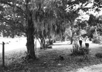
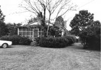
Lot on site affected by the widening of U.S. Route 17. Small house in background, obscured by trees. Presumably located in Mount Pleasant or vicinity. Surveyor notations on back of photo: "Dkt.: 10.597. Property owner: Mrs. Nancy T. McRae. Tract: 64. Station: 409+40 Lt. Date: Sept. 17, 1968." [See collection description for explanation of surveyor notations.]
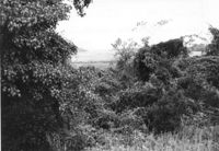
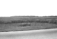
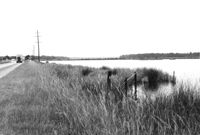
Lot and marsh land on site affected by the widening of U.S. Route 17. Presumably located in southern Charleston County. Surveyor notations on back of photo: "Dkt.: 10.600. Property owner: The Summerville Land Corp., Inc. Tract: 8. Station: 570± Rt. Date: Sept. 18, 1968." [See collection description for explanation of surveyor notations.]