Black-and-white engraving depicting Moses and the Ten Commandments. Engraving by Peter van Lisebetten after a painting by Valentin de Boulogne. From Davidis Teniers Antverpiensis, pictoris, et a cubiculis by David Teniers.
Black-and-white engraving depicting reading from a Torah scroll, above, and a Jewish circumcision, below. The Hebrew text on the Torah scroll reads : "In the beginning God created the heaven and the earth" (Genesis 1:1). Frontispiece from Johannis BuxtorfI patris, Synagoga Judaica : de judaeorum fide, ritibus, ceremoniis, tam publicis & sacris, quàm privatis, in domestica vivendi ratione by Johannes Buxtorf, published Basileae: Sumptibus authoris, apud Johan. Jacobum Deckerum.
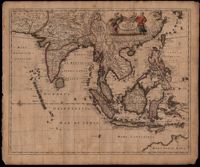
This map was engraved by Johannes L'Huilier and corrected by Frederick de Wit (1630-1706). The map encompasses the regions from India to Southern China, Taiwan, the Philippines, the East Indies and Indonesia with parts of northwest Australia identified as Hollandia Nova. Many islands with their ports are shown. The title cartouche at the top right is surrounded by turbaned warriors and native figures. 52 x 62cm.
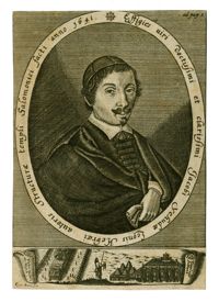
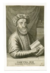
Black-and-white engraved portrait of Rabbi Jacob Judah Aryeh Leon Templo. Engraving by Conrad Buno. From De Templo Hierosolymitano, tàm priori, quod aedificavit Salomo rex, quàm posteriori, quod devastavit Vespasianus… by Jacob Judah Aryeh Leon Templo, published Helmstedt: Jacob Muller.
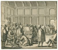
Black-and white engraving of the interior of the first synagogue building of Congregation Talmud Torah, which was established in 1639 upon the unification of three smaller Portuguese congregations, Beth Jacob, Neve Shalom and Beth Israel. Engraving by Jan Veenhuysen. From Beschryvinge van Amsterdam, Haar eerste oorspronk uyt den Huyze der Heeren van Aemstel en Aemstellant by Tobias van Domselaer.
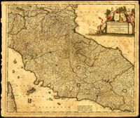
Map of central Italy by Frederick de Wit (1630-1706) showing the grand duchy of Tuscany and the papal states. Title cartouche is decorated with the ball-motif shield of the Medici family; the papal states are represented by the Keys of St. Peter on a shield. Detail on the map includes a road that extends from Rimina on the Gulf of Venetia to Piacenza in the northeast. Amsterdam. 52 x 62cm.
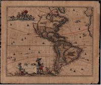
In this map by Gerrit van Schagen (1642-1690) California is a large island, there is one Great Lake (Lac contenant), a large open lake in place of the western Great Lakes, and the conjectural Northwest Passage, with the Straits of Anian. The elaborate title cartouche at the bottom left contains scenes of native Americans hunting, panning for gold and a chief standing beneath an umbrella. Also, the map shows other small illustrations: a war being waged by Indians in South America and a figure lying in a hammock. There is a large vignette at the top left of Neptune and his sons, the Tritons. 51 x 62cm.
![[Plate 240]](https://iiif.library.cofc.edu/iiif/2/40188/full/200,/0/default.jpg)