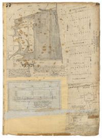
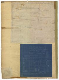
Page 35 of the City Engineer's Plat Book with five plats. Plat 1 shows land located near a creek with large portions marked with a different color. The plat shows a square labelled as "The Mall," and numerous streets, including Bay Street, Drake Street, America Street, Hanover Street, Columbus Street, Cooper Street, Blake Street, Amhurst Street, and Reid Street. There's also a stretch labelled as "Braggs Marsh." Plat 2 shows lots located between Congress Street and Mount Street, including a stretch of Hope Place. Plat 3 features a building labelled "Exchange," on East Bay Street, and near Gibbes Street and Champney Street. Plat 4 shows land with a partition wall and kitchen yards. Plat 5 shows land located near the "Citadel Athletic Field" and Grove Street.
Page 202 of the City Engineer's Plat Book with one plat. The plat shows lots located between Brigade Street and Williman Street, and between Meeting Street and a strip of land labelled "Atlantic Coast Line R.R." It also shows Nassau Street and Doran Street.
Page 208 of the City Engineer's Plat Book with one plat. The plat shows streets located between the Ashley River and Rutledge Avenue. It also shows Dunnemann Avenue, Grove Street, and Wagener Avenue.
Page 236 of the City Engineer's Plat Book with one plat. The plat features lots located between Romney Street and Cypress Street, and between King Street and a stretch of railroad tracks. Writing in red reads "See Page #242."
Page 210 of the City Engineer's Plat Book with two plats. Plat 1 features land set aside for a park, located between Lynch Street and Rutledge Street, and between Bennett Street and Calhoun Street. Plat 2 shows lots located between Simons Street and Gordon Street, near where they intersect with Rutledge Avenue.
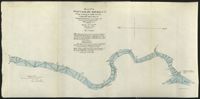
These five maps of the Waccamaw River in Horry County, S.C., show the river from Conway to Bull Creek. The surveys, dated November 1903, were performed under the direction of Captain G. P. Howell, Corps of Engineers U.S.A., and Reid Whitford, U.S. Assistant Engineer. The surveyor was William H. Johnstone.
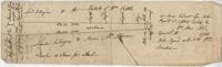
35 acres granted to John Izard in September of 1766 then sold to William B. Mitchell. Names associated with this plat are John Izard, William B. Mitchell, William Cattle, Isaac W. Mcpherson, James Brisbans, Mep Martha Miles, Samuel Wainwright, Gum Huhy [?], William Sanders. Notable geographic locations include St. Paul's Parish.