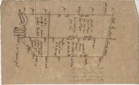
Plan of approximately 1500 acres on Black River near Georgetown part now belonging to Kinloch and Gadsden. Names associated with this plat are Gadsden, Kinloch, Alston, Thomas Gadsden, James Lloyd, and Morreau [?] Sarrazin.
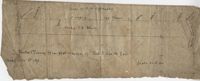
Plat contains land on the Santee River; acreage unknown. No structures are included. Names associated with this plat are S.G. Staney, A.M. Rickenbacher, and Fred J. Smith. Notable geographic locations include the Santee River.
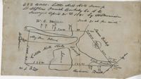
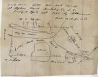
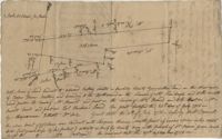
483 acre plot of Little Hell Hole Swamp, includes islands and surrounding property owners doesn't include land detail. Names associated with this plat are H.S. Morrison, Isaac Bishop, W.C. Miller, W.J. Ball, and Anderson. Notable geographic locations include St. Stephens Parish, Hog Pen Island, Little Hell Hole Swamp, and Berkeley County.
480 acre lot called Little Hell Hole Swamp, includes two islands and surrounding property owners, doesn't include land type. Names associated with this plat are H. Morrison, W.C. Miller, W.J. Ball, Issac Bishop and Anderson. Notable geographic locations include Hog Pen Island, Berkeley County, St. Stephen's Parish, and Little Hell Hole Swamp.
3.71 Acres of highland near marsh adjacent to Meeting Street Road. Names associated with this plat are Karl W. Ruth, A.F.C. Kramer, and S. Louis Simons.