500 acres surveyed for Thomas Ditom now Paul Blare. Includes Bacon Bridge Road. Names associated with this plat are Paul Blare, Dilton, William Way and Scotte.
Plan of 101 acres in St. James Parish, Goose Creek belonging to Abram Jones. Details include roads, ports, banks, trees and a field. Names associated with this plat are Abram Jones, Thomas Middleton, and Major Benjamin Smith. Notable geographic locations include Goose Creek, Charleston District, and Black River Road.
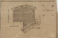
161 acres of land southeast of Pee Dee River. Details include rivers, a canal, and trees. Names associated with this plat are Mackie and William Stitt. Notable geographic locations include Waccamaw River and Pee Dee River.
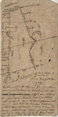
Tract of land belonging to May Ball in area known as Three Mile Head. Names associated with this plat are John Ball, Huger, Gourdin, E. Ball, May Ball and Caw. Notable geographic locations include Three Mile Head and Tartleberry.
Tract of land containing 416 acres. Details include trees, surrounding land, water, and roads. Notable geographic locations include St. John's Parish and Berkeley.
Copy of a plat of 150 acres and granted to Jobe Howes now forming part of Hickory Hill plantation in St. James Goose Creek and part in St. John and St. James Parish.
Plat of a part of Inverness sold from the estate of C. Huguenin to John Martin containing 538. Plat includes a railroad, a fort, a public road and fence. Names associated with this plat are C. Huguenin, John Martin, William Heyward, and Gunie [?]Williams. Notable geographic locations include Inverness and Pocotaligo Bridge.
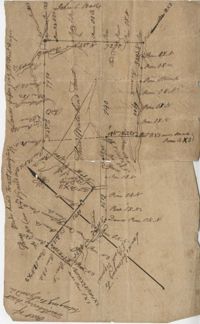
Plat of two tracts of land one for 360 acres and the other for 90 plat contains dates and names of the properties as well as a short chain of title. Names associated with this plat are John Musgrove, John Champneys, Sarah Champneys, William Stend, Robert Adams, George Jackson, Thomas Grumball, Sherriff C.D Elliott, Jabina, Col. William Ball, William John Champney, William Seads, and James St. John. Notable geographic locations include the Edisto River, Hickory Bridge and Colleton County.
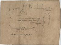
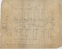
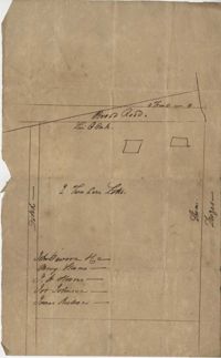
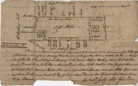
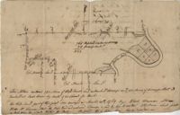
Sketch of lots near Dorchester now belonging to James Kennedy. Names associated with this plat are James Kennedy, Thomas Droger, John Dawson, M. Strom, J.H. Strom, J. Johnson, and J. Nilson. Notable geographic locations include Dorchester, St. George's Parish and Broad Road.
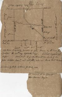
Plat of land belonging to Thobar butting and bounding 163 acres of land owned by Margaret Burger Master. Very little explanation of pertinent details on the plat. Names associated with this plat are Henry Thobhar, Margaret Burger Master, N. Winklin and J.L. Porcher.
Plat is laid out for 200 acres of land but when surveyor toured the land contained 547 acres apparently the surveyor did not "run the lines" properly when the land was first laid out and not setting corners. Names associated with this plat are Thomas Tucker, Archibald Crall, John Cook, Richard Ireland, Levey, John Linder, and James Stuard. Notable geographic locations include the Edisto River.
Plat of land belonging to General Cuthbert in the Beaufort District on the Pocotaligo River. Little other detail included in the plat besides the property lines, trees and the river. Names associated with this plat are Cuthbert Luna, Smith, Gordon [?], and Adam Jordan.
Plat laid out unto James St. John containing 375 acres of land in Colleton County. Names associated with this plat are James St. John, William Westbury, George Vincent, Samuel Sleigh, and John Godfrey. Notable geographic locations include Colleton County and the Pon Pon River.
Plan of Belle Island north of Four Mile Creek consisting of 316 acres. Names associated with this plat are Middleton, Richard Lowndes, and W.R. Maxwell. Notable geographic locations include Belle Isle, Four Mile Creek, and Manquils Creek.
Resurvey of a tract of land measuring 510 acres called Egan Hall belonging to John Egan situated in St. James Parish, Santee. Names associated with this plat are John Egan, Gredless and Ball. Notable geographic locations include St. James Parish, Santee, Egan Hall, and Bunker's Hill.
Copy of a plat of 765 acres of high land and swamp and 98 acres of swamp along Pee Dee River. Names associated with this plat are Colonel Powell, Saxby, Richfield, Wood Furman and Broughton. Notable geographic locations include St. George Parish, the Pee Dee River, Churning Crop Road, Richfield Plantation, and Georgetown District.
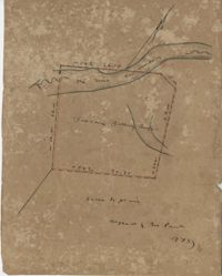
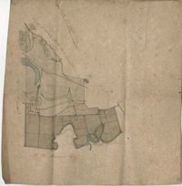
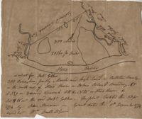
300 acre plot being partly marsh and highland in Colleton County, on the south side it is budding with the Stono River, shows surrounding property owners and minor creeks. Names associated with this plat are Robert Gibbes, Edward Fenwak, John Bremar and Bull.
Three separate 211 acre plots (633 total) of land that are budding and bounding on the south side by the Santee River, shows some trees at the property border and surrounding neighbors. Names associated with this plat are Major Ladson and William Moultrie. Notable geographic locations include the Santee River.
Sketch of land with no measurements or names, shows some trees and unnamed road/creeks. Names associated with this plat are John Michael and J.H. Alston. Notable geographic locations include Santee River and St. James Parish.