Page 117 of the City Engineer's Plat Book with two plats. Plat 1 shows lots located near the Cooper River. Plat 2 shows marshlands, bodies of water, and lots located near the Ashley River.
Page 120 of the City Engineer's Plat Book with five plats, labelled two through six. Plat 2 shows lots and buildings located near Cumberland Street, between Church Street and Philadelphia Street. Plat 3 shows lots located near the intersection Pinckney Street and Anson Street. Plat 4 shows lots and structures located on Hasell Street. Plat 5 shows lots and buildings along East Bay Street. Plat 6 shows lots and structures located between wharf street and the Cooper River.
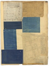
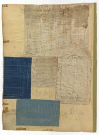
Page 125 of the City Engineer's Plat Book with seven plats. Plat 1 shows several measurements for a structure. Plat 2 shows the line of division between St. Mary's Church Yard and the "Property of Mrs. Anna D. Fleming." Plat 3 shows two wharves. Plat 4 shows lots and structures near wharf street. Plat 5 shows lots near the intersection of Washington Street and Laurens Street. Plat 6 shows lots between Rose Lane and Market Street, near where they intersect with East Bay Street. Plat 7 shows lots between Congress Street and Race Street, near Rutledge Street.
Page 135 of the City Engineer's Plat Book with seven plats. Plat 1 shows lots on a city block located between Bennett Street and Calhoun Street, and between Rutledge Street and Lynch Street. Plat 2 shows a lot labelled "Cannon's Mall," located on the intersection of Calhoun Street and Rutledge Street. Plat 3 shows lots located on Meeting Street. Plat 4 shows the same lot as Plat 2. Plat 5 shows a lot located on King Street. Plat 6 shows lots and structures located on King Street, including a graveyard, a Meeting House, and a kitchen.
Page 136 of the City Engineer's Plat Book with seven plats. Plat 1 shows lots and structures located on and near the intersection of Liberty Street and St. Philips Street. Plat 2 shows lots located on Archdale Street, near Bennett's Mill Pond. Plat 3 shows lots and structures located on and near the intersection of Rutledge Street and Montague Street. Plat 4 shows lots and structures located on Archdale Street, including a building labelled "Hope Engine House." Plat 5 shows a lot located along Clifford Alley, near a lot labelled "Unitarian Church." Plat 6 shows lots located along King Street. Plat 7 shows lots located on and near Calhoun Street, located between Smith Street and Rutledge Street.
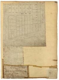
Page 144 of the City Engineer's Plat Book with five plats. Plat 1 shows lots on and near the Cooper River channel, near Boundary Street, Charlotte Street, Washington Street, and Alexander Street. Plat 1 also shows a creek and a stretch of marshland. Plat 2 shows lots located near the intersection of South Street and America Street. Plat 3 features structures located on the intersection of South Street and America Street. Plat 4 shows lots and structures located at the intersection of President Street and Cannon's Court. Plat 5 shows lots located between Drake Street, America Street, and Alexander Street.
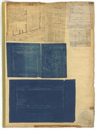
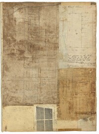
Page 145 of the City Engineer's Plat Book with seven plats. Plat 1 shows lots located on Chapel Street, near where they intersect with Alexander Street. Plat 2 shows lots and structures located on South Street, near where it intersects with another street. Plat 3 shows lots located along Anson Street, near where it intersects with Calhoun Street. Plat 4 features lots located on the "Eastern end of Wraggs" Street. Plat 4 shows lots and structures located between Concord Street and Wharf Street, near where they intersect with Inspection Street. Plat 5 features a strip of land belonging to the Charleston Gas Light Company, located near Concord Street. It also shows a "Train-way" and a building labelled "Gas Works." Plat 7 shows lots and structures located between Line Street and Sheppard Street.
Page 164 of the City Engineer's Plat Book with three plats. Plat 1 shows lots located between Meeting Street and Aiken Street, and between Cooper Street and Line Street. Plat 2 shows lots located on Felix Street. Plat 3 shows lots located on Grove Street, and shows a stream and a label reading "Frenchman's Hill."
Page 166 of the City Engineer's Plat Book with five plats. Plat 1 shows lots and structures located near the intersection of Columbus Street and Meeting Street. Plat 2 features lots located along Moultrie Street, between Meeting Street and Russel Street. Plat 2 also shows King Street and Hampton Street. Plat 3 shows lots located between Meeting Street and a line labeled "South Carolina R. R. Company," near Romney Street, Addison Street, and Poinsett Street. Plat 4 shows a lot located on the north side of Amherst Street. Plat 5 shows lots located near the intersection of Bay Street and Blake Street.
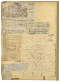
Page 228 of the City Engineer's Plat Book with two plats. Plat 1 shows the ground elevation near Mount Pleasant Street, between the Ashley River Marsh and the Cooper River Marsh. It also shows where Mount Pleasant Street intersects with Meeting Street and King Street. Plat 2 shows lots and structures located on and near Magazine Street, between Franklin Street and Smith Street.
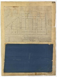
Page 213 of the City Engineer's Plat Book with two plats. Plat 1 features lots located between Savage Street and Chisolm Street, and between Tradd Street and Broad Street. Plat 1 also shows New Street, Rutledge Avenue, Lynch Street, Trapmann Street, and a lot labelled "Chisolm Mill Property." Plat 2 shows Calhoun Street's intersections with Lynch Street and Ashley Street.
Page 192 of the City Engineer's Plat Book with five plats. Plat 1 shows lots between Congress Street and King Street, from Gadsden Street to a city block past Moultrie Street. Plat 2 shows lots between Rutledge Street and King Street, and from Moultrie Street to a lot past Gadsden Street. Plat 3 shows a city block between Moultrie Street and Huger Street, and between Payne Street and Rutledge Street. Plat 4 shows lots near Rutledge Avenue, between Grove Street and Simons Street. Plat 4 also shows a street car line on Rutledge Avenue. Plat 5 shows lots between Sumter Street and Congress Street.
Page 189 of the City Engineer's Plat Book with three plats. Plat 1 shows lots between Moultrie Street and Huger Street, near where they intersect with King Street. Plat 2 shows lots located between Huger Street and Pinckney Street, near King Street. Plat 3 features a lot and budlings on Line Street.
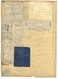
Page 185 of the City Engineer's Plat Book with four plats. Plat 1 shows lots and structures located near [Map too blurry to read, check when in-office]. Plat 2 shows lots and structures located near the intersection of Spring Street and Ashley Street. Plat 3 shows lots located near the intersection of Mount Street and Rutledge Avenue. Plat 4 shows lots located near Rutledge Avenue, between Congress Street and Huger Street.
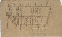
Plan of approximately 1500 acres on Black River near Georgetown part now belonging to Kinloch and Gadsden. Names associated with this plat are Gadsden, Kinloch, Alston, Thomas Gadsden, James Lloyd, and Morreau [?] Sarrazin.
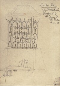
Pencil sketches by Charleston-born architect William Martin Aiken. Primarily architectural elements from churches and museums and generally from Italy, though some are in England and France.
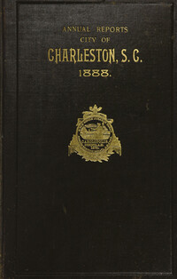
A report from the mayor, city council, and various governmental departments of Charleston, South Carolina, for the year 1888. The yearbook opens with an address from Mayor George D. Bryan followed by reports from various departments.
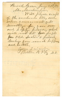
A letter from Dr. Arthur B. Flagg discussing a medical bill payment. The other side of the document includes an account with associated figures in dollars.
Color lithograph including depictions of Jewish women from Algiers. Lithograph by Daniel Urrabieta Vierge. Printed Paris: Imp. Firmin Didot et Cie. From Le costume historique, Volume 3, by Auguste Racinet, published Paris: Firmin-Didot et Cie.
Caricature by Charles Jay Taylor published in the August 8, 1888, edition of Puck. The text reads : --Ben and Levi: "You can haf dose clodings sheap, und we treat you mit a drink und a cigar! --Workingman: "Bah! You've been using those old togs for a sign for over twenty-five years. I'm going down to Cleveland's Free-Wool Emporium!"
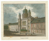
Hand-colored offset print reproduction of the exterior of the New Synagogue in Berlin. From L'Allemagne illustrée : géographie, histoire, administration, statistique, Volume 4, by Victor-Adolphe Malte-Brun.
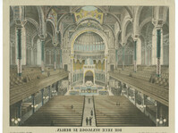
Hand-colored lithograph of the interior of the New Synagogue in Berlin. The print is made to be viewed using a zograscope. Published Berlin: Winckelmann & Söhne.
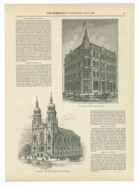
Black-and-white offset print reproduction of the exterior of the former location of Temple Beth Israel in Portland. Published in the May 1888 edition of The Northwest Magazine.
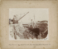
Still images found among the belongings of Henry T. Zacharias, a Charleston builder and contractor in the late 19th- and early-20th century. Zacharias built and/or repaired many notable buildings in Charleston. Includes photographs and one engraving of buildings on which he worked (or likely worked); photographs of battleships in dry dock at the Charleston Navy Yard; and a photograph of his gravesite at Magnolia Cemetery. (Note: Two of Mr. Zacharias's ledger books are in Special Collections at College of Charleston, 'Henry T. Zacharias Ledgers, 1905-1910.')
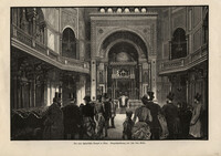
Black-and-white offset print reproduction of the interior of the Türkischer Tempel (Turkish Temple) in the Zirkusgasse in Vienna. From a drawing by Johann Nepomuk Geller. Published in the December 8, 1888, edition of the Illustrirte Zeitung.
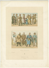
Color lithograph depicting people of Poland, including a Jewish man, woman, and child in the upper panel. From Le costume historique by Auguste Racinet, published Paris: Firmin-Didot et cie.

![[Kapparot]](https://rspace.library.cofc.edu/iiif/image/39730/full/200,/0/default.jpg)