City Engineers's Plat Book, 1671-1951, Page 213
Close Viewer
- Title:
- City Engineers's Plat Book, 1671-1951, Page 213
- Date:
- 1888
- Description:
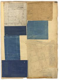
- Page 213 of the City Engineer's Plat Book with two plats. Plat 1 features lots located between Savage Street and Chisolm Street, and between Tradd Street and Broad Street. Plat 1 also shows New Street, Rutledge Avenue, Lynch Street, Trapmann Street, and a lot labelled "Chisolm Mill Property." Plat 2 shows Calhoun Street's intersections with Lynch Street and Ashley Street.
- Collection Title:
- City Engineers's Plat Book, 1671-1951
- Contributing Institution:
- The Charleston Archive at CCPL, City of Charleston
- Media Type:
- Maps
- Personal or Corporate Subject:
- Barbot, Louis J., Dingle, J. H. (James Hervey), 1869-1938
- Topical Subject:
- Cadastral maps, Surveys
- Geographic Subject:
- Charleston (S.C.)
- S.C. County:
- Charleston County (S.C.)
- Language:
- English
- Date Digital:
- 2023
- Digitization Specifications:
- 300 dpi, 24-bit depth, color, i2S SupraScan Quartz A0. Archival masters are tiffs.
- Format:
- image/jpeg
- Copyright Status Statement:
- Public domain.
- Access Information:
- This City of Charleston has placed this collection on permanent loan with the Charleston County Public Library. For more information and reuse requirements contact The Charleston Archive at Charleston County Public Library, 68 Calhoun Street, Charleston, SC 29411.
- Admin ID:
- 296846
Permalink