Letter from Major General Nathanael Greene addressed to Arthur Campbell regarding the ongoing hostilities in the states of North Carolina and Virginia. Greene is advising Campbell on how to best achieve peace with the Cherokee and Chiccasaw Native American tribes.
Letter from Gouverneur Morris to Nathanael Greene regarding the issues the government encountered when attempting to pay the soldiers of the Revolution and discussing possible solutions.
Letter from Samuel H. Parsons to Nathanael Greene regarding the general state of political affairs as the war draws to a close. General Parsons voices his concerns on the activities of Congress and his doubt that military officers will have a voice in political affairs post-war.
Letter from Stephen Drayton to Nathanael Greene requesting to be employed in his army and relaying the information he had received from Philadelphia regarding the movements of the French as they hastened to aid the Revolutionary troops.
Letter from Nathaniel Pendleton to Nathanael Greene anticipating the peaceful end to the war and relaying general news of the growing society they have established on Kiawah Island; containing his wife, in addition to the families of Colonel [William] Washington, Captain Wilmot, and Mr. Gibbs. The second half of the letter discusses the ill health of various persons.
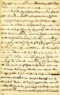
Letter from Mann Page, Jr. to John Page appraising his brother of his bout with smallpox, preparation for an enemy invasion in Philadelphia, the British blocking of trade, the loss of a ship with her captain and supplies, and reporting the expected renewal of British forces in the spring.
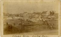
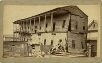
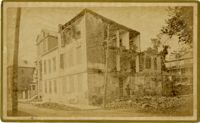
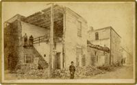
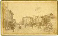
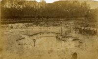
Charleston Earthquake scene. Labeled 'Old Hospital' in lower left corner, with 'Trapman Street' handwritten at bottom, front. Additional note on reverse: 'See Cook No.189 [from Series 2, which is captioned as 'Ruins of Colored hospital.']
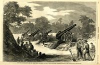
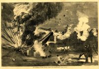
Caption: 'The Siege of Charleston--the new Black Island Batteries, four and a half miles from Charleston.--sketches by Mr. Theodore R. Davis.--[see page 651.]' [full date October 10, 1863.]
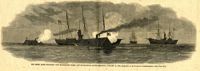
Caption: 'The Rebel rams engaging our blockading fleet off Charleston, South Carolina, January 31, 1863.--sketched by an occasional correspondent.--[see page 127.]' [full date January 21, 1863.]
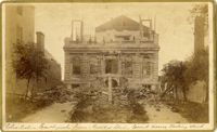
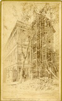
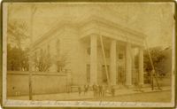
Caption: 'Cook's Earthquake Views of Charleston and Vicinity. Taken after the 31st of August, 1886. No.8, U.S. Court House.' Written on bottom, at front: 'Charleston Earthquake scene - United States Court House, Meeting Street.'
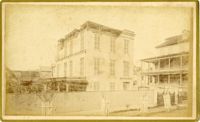
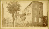
Caption: 'Cook's Earthquake Views of Charleston and Vicinity. Taken after the 31st of August, 1886. No.91, Brawley House, Legare Street.' Charleston city directory for 1886 shows Wm. H. Brawley at 9 Legare Street.
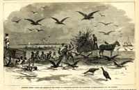
Caption: 'Southern scenes.--fight for garbage in the streets of Charleston between the scavengers (turkey-buzzards) and the Negroes.' [full date December 11, 1869.]
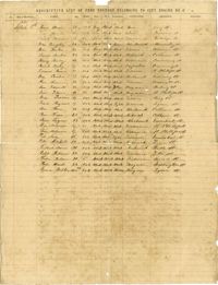
List of volunteer firefighters of city engine number 2, including their names, ages, description, occupation, and residence. Donated to the Charleston Museum by Charles Pequette, 1925
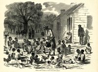
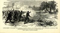
Caption: 'A detachment of the First South Carolina (Colored) Federal Volunteers, Colonel Beard, repelling an attack of the Confederate troops in the vicinity of Doboy River, Ga. From a sketch by Colonel Brewerton.'
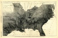
Caption: 'Map of the Southern states, showing the relative proportion of slaves in the different localities.--[see page 142.]' [full date February 28, 1863.]
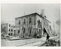
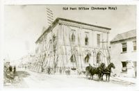
Caption: 'Cook's Earthquake Views of Charleston and Vicinity. Taken after the 31st of August, 1886. No.125, Scene near Atlantic Wharf.' Charleston city directory for 1886 lists Atlantic Wharf at the rear of the Post Office.
Caption: 'Cook's Earthquake Views of Charleston and Vicinity. Taken after the 31st of August, 1886. No.82, East Bay Street.' Sign for Jas [James] Ackermann at 114 East Bay is visible.
Caption: 'Cook's Earthquake Views of Charleston and Vicinity. Taken after the 31st of August, 1886. No.99, Rear of Scotch Church.' Handwritten at bottom, front: 'Charleston Earthquake scene - Rear of First Presbyterian Church.'
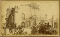
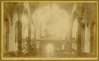
Caption: 'Cook's Earthquake Views of Charleston and Vicinity. Taken after the 31st of August, 1886. No.99, Rear of Scotch Church.' First (Scots) Presbyterian Church on Meeting Street.
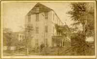
Caption: 'Cook's Earthquake Views of Charleston and Vicinity. Series No.2. No.170, Buist residence, Rutledge Street.' Written on front, at bottom: Buist Residence, 43 Rutledge St.' Charleston city directory for 1886 shows listing for Samuel S. Buist at 43 Rutledge Avenue.
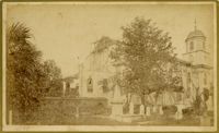
Caption: 'Cook's Earthquake Views of Charleston and Vicinity. Taken after the 31st of August, 1886. No.79, St. Mary's Church. [And handwritten] Hasell Street.'
Caption: 'Cook's Earthquake Views of Charleston and Vicinity. Taken after the 31st of August, 1886. No.135, Corner State and Chalmers Streets.' Written on front, at bottom: 'Charleston Earthquake views - ruins cor[ner] Chalmers & State Str.'
Caption: 'Cook's Earthquake Views of Charleston and Vicinity. Series No.2. No.187, residence of Mr. A. Lengnick.' Charleston city directory for 1886 shows Albert Lengnick at 11 Pitt Street.
Letter from Benjamin Lincoln to Nathanael Greene regarding the issues the government encountered when attempting to pay the soldiers of the Revolution and discussing possible solutions. General discussions of economics, the nature of the relationship with France, and establishing trade with several Spanish ports are also discussed.
Letter from John Cox to Nathanael Greene reporting an encounter between 800 Continental troops, North Carolina militia, Virginia militia, and the British. Cox reports that the American troops were outnumbered and eventually defeated by Lord Cornwallis and his men.