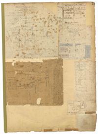
Page 224 of the City Engineer's Plat Book with one plat. The plat features lots and structures belonging to a refining company. It also shows several streams, a right-of-way for a rail line, America Street, Hanover Street, Centre Street, and Meeting Street.
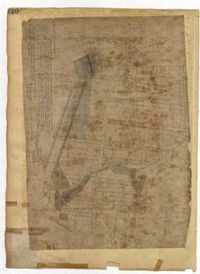
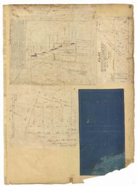
Page 220 of the City Engineer's Plat Book with one plat. The plat shows lots extending from the Ashley River, past Lucas Street. The plat also shows Doughty Street, Calhoun Street, President Street, U. S. Arsenal Square, and several structures.
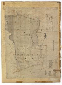
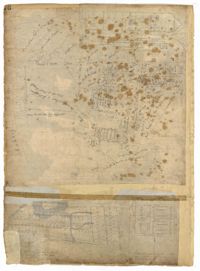
Page 226 of the City Engineer's Plat Book with one plat. It shows lots located between Rutledge Avenue and King Street, and between Race Street and Sheppard Street.
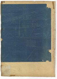
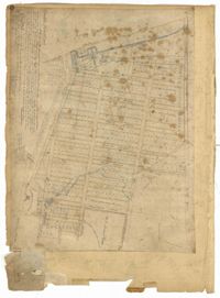
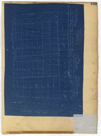
Page 225 of the City Engineer's Plat Book with one plat. The plat shows lots and marsh located east of King Street and north of Line Street. It also shows Meeting Street.
Page 145 of the City Engineer's Plat Book with seven plats. Plat 1 shows lots located on Chapel Street, near where they intersect with Alexander Street. Plat 2 shows lots and structures located on South Street, near where it intersects with another street. Plat 3 shows lots located along Anson Street, near where it intersects with Calhoun Street. Plat 4 features lots located on the "Eastern end of Wraggs" Street. Plat 4 shows lots and structures located between Concord Street and Wharf Street, near where they intersect with Inspection Street. Plat 5 features a strip of land belonging to the Charleston Gas Light Company, located near Concord Street. It also shows a "Train-way" and a building labelled "Gas Works." Plat 7 shows lots and structures located between Line Street and Sheppard Street.
Page 141 of the City Engineer's Plat Book with four plats. Plat 1 features a lot and structures located between Lynch Steet and the Ashley River, near Broad Street. It also shows Comings Creek, a pond, and a lot labelled "Clark & Steinmeyer." Plat 2 shows lots and structures located near the intersection of College Street and Calhoun Street. Plat 3 shows a lot and structures in "the City of Charleston in Ward No. 9." Plat 4 shows lots on and near Society Street, between Meeting Street and King Street.
Page 144 of the City Engineer's Plat Book with five plats. Plat 1 shows lots on and near the Cooper River channel, near Boundary Street, Charlotte Street, Washington Street, and Alexander Street. Plat 1 also shows a creek and a stretch of marshland. Plat 2 shows lots located near the intersection of South Street and America Street. Plat 3 features structures located on the intersection of South Street and America Street. Plat 4 shows lots and structures located at the intersection of President Street and Cannon's Court. Plat 5 shows lots located between Drake Street, America Street, and Alexander Street.
Page 154 of the City Engineer's Plat Book with three plats. Plat 1 shows lots and structures located between Radcliffe Street and Warren Street, near where they intersect with Coming Street. Plat 2 shows lots and structures located between Thomas Street and Smith Street. Plat 3 shows lots and structures located near the intersection of St. Philips Street and Vanderhorst Street. Plat 3 also includes labels reading "Kitchen building," and "Lot of the Irish Volunteers."
Page 151 of the City Engineer's Plat Book with two plats. Plat 1 shows lots and structures located on and near Anson Street. Plat 2 shows lots and structures located between Coming Street and the Ashley River Channel, and between Elliott Street and Mill Creek. The plat also shows 50 acres of marsh, several bodies of water, Boundary Street, Pinckney Street, Cannon Street, and President Street.
Page 153 of the City Engineer's Plat Book with three plats. Plat 1 shows lots located between Rutledge Street and Lynch Street, near where they intersect with Calhoun Street. Plat 2 shows lots located on and near the intersection of Rutledge Avenue and a private court. Plat 3 shows lots located between Smith Street and Ogier Street, near where they intersect and Vanderhorst Street.
Page 148 of the City Engineer's Plat Book with two plats. Plat 1 shows lots and structures located on and near Calhoun Street, between Washington Street and the Cooper River. Plat two shows "Lots in the Village of Rikersville," including 21 acres of marshland, a canal, and a pond.
Page 152 of the City Engineer's Plat Book with three plats. Plat 1 shows lots and structures located on King Street. Plat 2 shows lots located on Luhn's Court, near where it intersects with Smith Street. Plat 3 shows lots and structures located on and near the intersection of Morris Street and King Street.
Page 149 of the City Engineer's Plat Book with one plat. The plat shows lots located between Meeting Street and King Street, including a stretch of railroad.
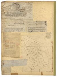
Page 72 of the City Engineer's Plat Book with eight plats. Plat 1 is labelled as a "Plan of Mazyckborough" and shows land located near the intersections of Charlotte Street with Alexander Street and Washington Street. Plat 1 also shows marshlands, streams, and the Cooper River. Plat 2 features a lot and its structures located on Henrietta Street. Plat 3 shows lots located between Concord Street and the edge of the Cooper River Channel, and also shows Wharf Street. Plat 5 shows land and buildings located on Washington Street, and includes some marshland and a stream labelled "Creek to Cooper River." Plat 6 shows a "Plan of a Part of Wraggsborough" located between Elizabeth Street and the Cooper River Channel. The plat also labels some marshlands, part of a creek, Mazyckborough, the Village of Hampstead, "The Mall," Chapel Street, and Washington Street. Plat 7 shows a lot located near the intersection of King Street and Calhoun Street, and shows several structures including a kitchen. Plat 8 shows a plan for a market located on Boundary Street, near Water Street, Front Street, and Gadsden's Canal.
Page 71 of the City Engineer's Plat Book with eight plats. Plat 1 shows lots and structures on a city block between Rutledge Street and Smith Street, and between Beaufain Street and Wentworth Street. Plat 2 shows lots located near the intersection of Moore Street and Meeting Street. Plat 3 shows lots and structures located near the intersection of King Street and Beaufain Street. Plat 4 shows lots and structures located on the east side of Coming Street. Plat 5 shows lots located on King Street, including a lot labelled "Unitarian Church property" and a stretch labelled "Unitarian Church Cemetery." Plat 6 shows lots located on King Street, and shows the "Old line of street." Plat 7 shows plots located on King Street. Plat 8 features a lot and buildings located on Spring Street, and shows how Rosemont Street is projected to cross that property.
Page 73 of the City Engineer's Plat Book with six plats. Plat 1 shows lots and some buildings located near the intersection of Chapel Street and Alexander Street. Plat 2 shows lots located near King Street's intersections with Radcliffe Street, Vanderhorst Street, Hutson Street, John Street, and Ann Street. The plat also shows Meeting Street, the Mall, and a body of water. Plat 3 shows lots, structures, and marshland located near the intersection of Coming Street and Smith Street. Plat 4 shows lots and some buildings located near John Street, between King Street and a some "Rail Road Land." Plat 5 shows lots located near King Street, between Tobacco Street and Calhoun Street. Plat 6 features a stretch of land between King Street and Meeting Street, along John Street's north side and near Radcliffe Street. The plat also shows a feature labelled "Ravine."
Page 76 of the City Engineer's Plat Book with three plats. Plat 1 shows land roughly between the Ashley River and Coming Street, and roughly between Elliot Street and Comings Creek. Plat 1 also shows multiple streams, marshes, and islands. It also includes Boundary Street, Doughty Street, Bee Street, Cannon Street, Smith Street, Pinckney Street, and Thomas Street. Plat 2 shows lots and some buildings located between Spring Street and a marsh, along an road labelled "Court." Plat 3 features lots located between Morris Street and Radcliffe Street, near their intersections with Pitt Street, "Commings Street," St. Philips Street, and King Street. Plat 3 also shows some marshland. Plat 4 features lots located between Smith Street and Coming Street, and between Radcliffe Street and Vanderhorst Street. Plat 4 also shows the intersection of Warren Street and Thomas Street.
Page 69 of the City Engineer's Plat Book with eight plats. Plat 1 shows land located on either side of Burns Lane, and also shows George Street. Plat 2 features a lot and some buildings on George Street. Plat 3 features lots located on and near King Street, between Beaufain Street and Lynch Street. Plat 4 shows a city block located between Beaufain Street and Wentworth Street, and between Pitt Street and Kirkland Lane. Plat 5 shows lots and some buildings located near the intersection of Smith Street and Montague Street. Plat 6 shows lots on Coming Street, between Montague Street and Wentworth Street. Plat 8 shows lots and some buildings located on Pitt Street, including a lot labelled "The Brown Fellowship Society Cemetery."
Page 75 of the City Engineer's Plat Book with six plats. Plat 1 features lots located between Radcliffe Street and Calhoun Street, and between Smith Street and Rutledge Street. Plat 1 also shows Vanderhorst Street, Thomas Street, and Warren Street. Plat 2 shows lots located near Morris Street, between St. Philips Street and Coming Street. Plat 3 shows lots located near the intersection of Morris Street and Coming Street, including a lot labelled "Cemetery" and another lot labelled "Hebrew Cemetery." Plat 4 shows land located near Thomas Street, between Doughty Street and Hutson Street, and also labels a pond. Plat 5 shows lots located between Pine Street and Gadsden Creek. Plat 6 shows lots and some buildings located between Pinckney Street and Smith Street.
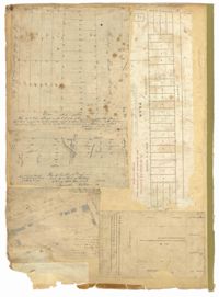
Page 84 of the City Engineer's Plat Book with five plats. Plat 1 shows lots located near Meeting Street, between Sheppard Street and Line Street. Plat 2 shows lots located along Race Street, between Rutledge Street and King Street. Plat 3 shows lots located between King Street and Meeting Street, and shows a stretch of Russell Street. Plat 4 features a lot and several buildings located near the intersection of Line Street and Meeting Street. Plat 4 also shows a label reading "The Rail Road" and another reading "Rail Road Company." Plat 5 features a lot on Hanover Street, and also shows a lot labelled "Cemetery."
Page 85 of the City Engineer's Plat Book with three plats. Plat 1 shows the "Village of Hampstead," between Boundary Street and Mary Street, and between King Street and the Cooper River. The plat also shows City Lands, stretches of March, a stream, Wragg Square, the Mall, and Mazyckborough. Other streets shown include Washington Street, Alexander Street, Chapel Street, and Meeting Street. Plat 2 shows a similar stretch as Plat 1, but with different boundary lines for the lots. Plat 3 shows lots and structures located near King Street.
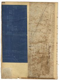
Page 80 of the City Engineer's Plat Book with one plat. The plat shows a plan for developing a stretch of land from the Ashley River towards President Street and Lucas Street, with a few lots and structures further east. The plat also shows a lot labelled "U. S. Arsenal Square," and a mill on the Ashley River.
Page 2 of the City Engineer's Plat Book with five plats. Plat 1 shows the intersections of Guignard Street with East Bay Street and "Raper's Alley," and features a building labelled "Old Mansion Ruins." Plat 2 shows the intersection of East Bay Street and Market Street near the "Charleston Harbour on the Cooper River," and features plans to expand Market Street. Plat 3 features a stretch of land from the end of Rose Alley to the Cooper River, labelled as "Union Warf No. 1." Plat 4 features the same stretch of land as Plat 2 with slightly more land to the north. Plat 5 features the intersections of Tradd Street with Legare Street and Friend Street.
Page 4 of the City Engineer's Plat Book with seven plats. Plat 1 features East Bay Street, Pinckney Street, Concord Street, and lots labelled "Burnt District." Plat 2 features lots on King Street. Plat 3 shows several lots on East Bay Street near the intersections with Pritchard Street and Hard Alley. Plat 4 shows three lots on East Bay Street. Plat 5 features lots at the intersection of East Bay Street and Hasell Street. Plat 5 shows a stretch of Queen Street including the intersections with Archdale Street and Friend Street, and includes a plat labelled "Catholic Church." Plat 7 shows plots of land on the intersection of Tradd Street and Meeting Street.
Page 1 of the City Engineer's Plat Book with four plats. Plat 1 shows the intersection of East Bay Street and Market Street, and labels reading "New Custom Ho.," "Old Flash," "Scale House," and "Market." Plat 2 shows a stretch of East Bay Street from the intersection with Guignard Street to Pritchard Street, including the bridge crossing over Canal Street. Plat 3 shows the intersection of Tradd Street and Greenhill Street. Plat 4 features Beaufain Street's intersections with St. Phillip Street and Archdale Street, and features a plot of land labelled "Normal School Yard."
Page 3 of the City Engineer's Plat Book with four plats. Plat 1 features lots at the intersection of Laurens Street and East Bay Street, and labels a section of salt marsh. Plat 2 shows plots at the intersection of East Bay Street and Hasell Street. Plat 3 features three lots of land and buildings on East Bay Street. Plat 4 shows a stretch of Pinckney Street between Bay Street and the Cooper River, including several lots.
Page 8 of the City Engineer's Plat Book with two plats. Plat 1 shows plots near "Village Hampstead Public Square" and shows numerous streets including King Street, Columbus Street, and Meeting Street. Plat 2 shows lots near the intersection of Radcliffe Street and King Street, including a lot labelled "Estate of McIntosh."
Page 9 of the City Engineer's Plat Book with four plats. Plat 1 shows lots near the intersection of Cannon Street and Smith Street. Plat 2 features plots of land and buildings located near Savage Street. Plat 3 shows plots of land located near the intersection of Queen Street and Rutledge Street. Plat 4 features lots on Simons Street.
Page 10 of the City Engineer's Plat Book with two plats. Plat 1 shows plots located near Pointset Street and Grove Street between King Street and Russell Street. Plat 2 shows plots near Judith Street and Chapel Street, and includes "Beaufort's Court" and "Heyward's Court."
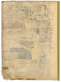
The front page of the City Engineer's Plat Book with two plats. The topmost plat shows a stretch of marshland located on the Ashley River. The bottom plat shows a stretch of land on the Cooper River.
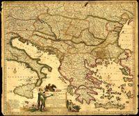
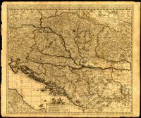
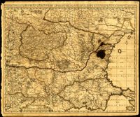
Map by Justus Danckerts (1635-1701) covers the Danube River from Germany to the Black Sea. Depicts all of the Balkans, Hungary, Romania and parts of Austria, Italy and Germany. The map was apparently printed at the height of the Ottoman wars against the European powers in the late seventeenth century. A table in the lower left depicts the names of cities in the Hungarian kingdom that were lost to the Ottomans and when they were recovered to date. The latest date on the table is 1687. However, according to the table, the recapture of Buda (Budapest) took place in 1686 but an examination of Buda on the map reveals a date of 1688. Other known examples of this map include the recovery of Belgrade (Belgrado) in 1688 in the table although this version of the map does not. It is possible this map was printed immediately before the Siege of Belgrade in 1688 or after 1690 when the city was reclaimed by the Turks (and the subsequent reference to Belgrado in the table may have been expunged). Title cartouche depicts a Christian saint and the Hapsburg eagle. Amsterdam. 52 x 62cm.
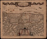
This map was engraved by Frederick de Wit (1630-1706), one of the most prominent and successful publishers in Amsterdam. The Holy Land extends from Sidon and Damascus to the Wilderness of Pharan in the Sinai. The decoration in the map relates to the Old Testament. At the bottom of the map is a depiction of an encampment of the Israelites during Exodus. The Twelve Tribes are around the perimeter and in the center the Tabernacle is illustrated with the Levites in attendance. Moses is at the left holding his staff and his brother Aaron is opposite. The caption in the sea refers to Lebanese cedars being sent by King Hiram of Tyre to King Solomon. The theme of the richness of the Promised Land is emphasized with the beautiful garland supported by the angels across the top, containing fruit, grapes and flowers. North oriented to the right. Amsterdam. 52 x 62cm.
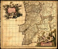
Map of Portugal and Algarve by Johannes de Ram (1648-1693). The title cartouche in the upper left depicts cherubs holding the Portuguese coat of arms; a note within the cartouche explains that the longitudinal lines on the map are based from the prime meridian that runs through Tenerife in the Canary Islands. The scale cartouche in the lower right features Neptune with a trident and two cherubs holding the coat of arms of Algarve, then a semi-autonomous region of Portugal. Amsterdam. 52 x 62cm.
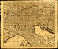
One of three maps by Nicolaes Visscher (1649-1702) collectively showing the entire length of the Danube. This map covers the middle part of the river from Linz through Vienna, Bratislava and Budapest, to just east of Belgrade. Amsterdam. 52 x 62cm.
One of three maps by Nicolaes Visscher (1649-1702) collectively showing the entire length of the Danube. This map depicts the upper Danube from its start in Germany to Bratislava (Presburg on map). Amsterdam. 52 x 62cm.
One of three maps by Nicolaes Visscher (1649-1702) collectively showing the entire length of the Danube. This map depicts the lower Danube from Belgrade to its mouth in the Black Sea. Amsterdam. 52 x 62cm.
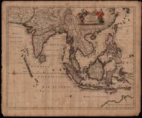
This map was engraved by Johannes L'Huilier and corrected by Frederick de Wit (1630-1706). The map encompasses the regions from India to Southern China, Taiwan, the Philippines, the East Indies and Indonesia with parts of northwest Australia identified as Hollandia Nova. Many islands with their ports are shown. The title cartouche at the top right is surrounded by turbaned warriors and native figures. 52 x 62cm.
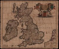
Map of the British Isles by Theodore Danckerts (1663-1727) also includes part of the European coast. The decorative title cartouche is in the upper right corner with putti supporting the shields of Scotland, Ireland and England; the mileage scale is given in the lower left corner. Amsterdam. 52 x 62cm.
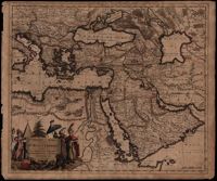
A map of Turkish possessions including Egypt and Greece by Justus Danckerts (1635-1701) shows the Arabian peninsula in the center. A decorative cartouche adorned with several costumed figures, a pyramid, and lions. Amsterdam. 52 x 62cm.
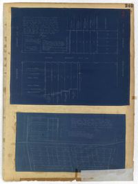
Page 235 of the City Engineer's Plat Book with four plats. Plat 1 features a proposed right-of-way through Chicora Park, and shows a state road, Clements Avenue, Pine Avenue, and a label reading "U. S. Navy Yard." Plat 2 shows land located near the intersection of Grove Street and Rutledge Avenue, with one plot labeled "Trustees of the Endowment Fund of the Charleston Library Society." Plat 3 shows lots, structures, and marshland located on and near the Ashley River, north of Congress Street. the fourth plat is a pencil-sketched map showing land located near the intersection of Rutledge Avenue and Grove Street.
Page 237 of the City Engineer's Plat Book with three plats. Plat 1 shows "property situated on the west side of Rutledge Avenue," most of which is situated between Grove Street and Moultrie Street. Plat 1 also marks a "Brick Dwelling" and a stretch of marsh land. Plat 2 features land labeled "Trustees of the Endowment Fund of the Charleston Library Society," located between Rutledge Avenue and the Ashley River. Plat 3 shows land located on Huger Street, between King Street and Meeting Street.
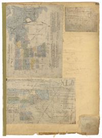
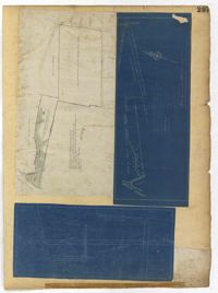
Page 229 of the City Engineer's Plat Book with two plats. Plat 1 features lots located on Queen Street, near its intersections with Mazyck Street, Friend Street, King Street, and Meeting Street. Plat 2 features lots located between Sans Souci Street and Simons Street, and between Rutledge Avenue and King Street.
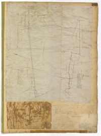
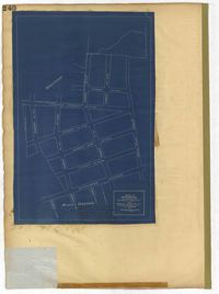
Page 247 of the City Engineer's Plat Book with one plat. The plat shows lots located from the west side of Ashley Avenue to King Street, between Mount Pleasant and Sans Souci Street. The plat also shows Darlington Street, Rutledge Avenue, Magnolia Street, Tracy Street, and Laurel Avenue.
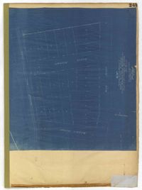
Page 240 of the City Engineer's Plat Book with one plat. The plat shows "The Property of Riverside Park Inc. and Peerless Securities Co." The streets shown include Rutledge Avenue, Sans Souci Street, Hester Street, and Ashley Avenue.
Page 245 of the City Engineer's Plat Book with two plats. Plat 1 shows lots located on and near Seyle Street, between Huger Street and Moultrie Street. Plat 2 shows lots on and near Grove Street, between Rutledge Avenue and King Street. Plat 2 also shows Tracy Street.
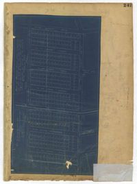
Page 242 of the City Engineer's Plat Book with one plat. The plat shows lots located on and near King Street, between Cypress Street and Romney Street. It also features a stretch of railroad track.
Page 241 of the City Engineer's Plat Book with one plat. The plat shows lots on and near King Street, Baxter Street, and Lenox Street. It also shows the end of Sans Souci Street.
Page 150 of the City Engineer's Plat Book with five plats. Plat 1 shows lots located between President Street and the Ashley River, and between Spring Street and Mill Street. It also shows an "Ashley River Bridge" on Spring Street, and a lot labeled "Charleston and Savannah R.R." Plat 2 shows lots and structures located on the west side of Rutledge Avenue. Plat 3 features a lot located on the corner of St. Philips Street and Calhoun Street. Plat 4 shows lots located on the east side of Rutledge Avenue. Plat 5 shows lots and structures located on King Street, including labels reading "Upper Police Station" and "Cistern Underground."
Page 158 of the City Engineer's Plat Book with four plats. Plat 1 shows lots located on South Street, near where it intersects with Hanover Street. Plat 2 shows lots located on and near Mill Street, near its intersections with Lucas Street and President Street, and shows a building labelled "Dead House" and a creek labeled as "leading to canal." Plat 3 shows lots and structures located on East Bay Street. Plat 4 shows South Bay Street and its intersections with Legare Street and King Street.