A collection of five maps and three charts describing land owned by Jonah Horry in South Carolina. The first four maps were drawn from surveys made by John Goddard in 1793; the last map was drawn from a survey made by John Horry Dent in 1836.
Copy of a plat of 490 acres owned by Francis Smith annexed to the lands owned by Laughlin McIntosh. Names associated with this plat are Francis Smith, Laughlin McIntosh, Beadon Colonel, Captain Hutchinson, and Thomas Fleming. Notable geographic locations include St. Bartholomew's Parish, Chickaw and Charleston District.
Copy of plan of a plantation on Stono Swamp commonly called Stono Plantation belonging to Thomas Ferguson. Contains 630 acres. Approximately 360 acres is swamp and approximately 270 acres is highland. Names associated with this plat are Thomas Ferguson, George Haig, Joseph Farr, Mary Williams, Smith and John McSweeney. Notable geographic locations include Stono Swamp, Stono Plantation and Charleston.
650 acres belonging to Thomas Cordes on eastwest side of Fishpond Creek/ Ashepoo River bounding northwest on Elizabeth Woodward and south by Captain John Gibbes. Names associated with this plat are Thomas Cordes, Elizabeth Woodward, Captain John Gibbes, and Robert Johnson. Notable geographic locations include Fishpond Creek, the Ashepoo River and St. Bartholomew's Parish.
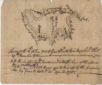
Copy of plat of 342 acres on Johns Island. Very little detail, just an outline of the property with trees on the edges. Names associated with this plat are Thomas Ladson, Hanscome, Allen, William Wallisby, Robert Murens, and Brocher. Geographic locations are the Stono River, Colleton County and Johns Island.
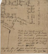
Plat of 222 acres granted to and acquired by Elias Horry on the Santee River. Names associated with this plat are Elias Horry and Izard. Names associated with this plat are Elias Horry and Izard. Notable geographic locations are Santee River, Toby Creek, Wild Hook Creek.
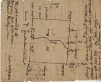
Plat of 100 acres of land conveyed by William Norman to Edward Keating situated at Goose Creek. Names associated with this plat are Edward Keating, William Norman, John Bayly, and Moultrie. Notable geographic locations are Goose Creek.
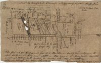
Plat of 4883 acres belonging to Thomas Smith. Very little detail, only the outline of the property is included. Names associated with this plat are Thomas Smith, General Oglethorpe, Smith, Thomas Elliott, Hugh Bryan, and Allen. Notable geographic locations include Granville.
Copy of plat of 230 acres granted to Bryan Presly in Colleton County on Pon Pon River. Names associated with this plat are Bryan Presly, and John Bull, and Hendrich. Notable geographic locations include Pon Pon River and Colleton County.