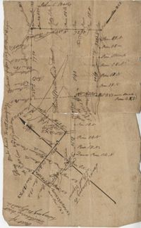
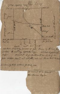
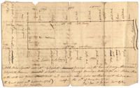
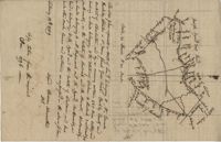
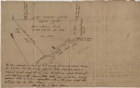
200 Acre plot of land laid out to John Freer, shows some creeks and trees, no land type or details. Names associated with this plat are John Freer, Stephen Bull, Joseph Blake, William Weston, William Green, and B. Sam. Notable geographic locations include Colleton County, Freer District, and Wadmalaw River.
Plat of 320 acres in the Georgetown District on the Black Mingo waters with marshes surrounding it. Little detail included. Names associated with this plat include Thomas Bull, Job Rothmaler, McCottry, Robert Davidson, Hugh Swinton and Sam Day.
Plat of two tracts of land (1000 acres) adjoining each other on the north side of the Santee River now belonging to the estate of Brown. Copy from the plat annexed to the orginal grants from the Lords Proprietors. Names associated with this plat are Peter Gaillard, Brown, Henry Bruneau and The Lords Proprietors. Notable geographic locations include the Santee River and Dohov Swamp and Creek.
Plat of 383 acres on Mary Creek Swamp belonging to Joseph Coachman. Details include the property lines, the location of the swamp, and location of a few trees. Names associated with this plat are Joseph Coachman, J. Hardwick, John LaBruce, Cattle, and Ralph Izard.
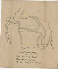
Plat of land belonging to General Cuthbert in the Beaufort District on the Pocotaligo River. Little other detail included in the plat besides the property lines and the river. Names associated with this plat include Luna Cuthbert and Cuthbert.
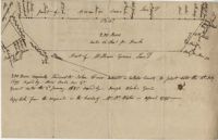
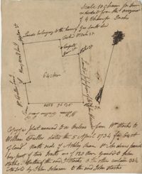
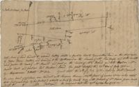
500 acres surveyed for Thomas Ditom now Paul Blare. Includes Bacon Bridge Road. Names associated with this plat are Paul Blare, Dilton, William Way and Scotte.
A 550 acre plot of land given to Francis Middleton, the entire plot is labeled as marsh located on the banks of the branches of the Santee River. Names associated with this plat are Francis Middleton, Ephraim Mitchell, Josh Purcell and A. Darby. Notable geographic locations included are St. James Parish.
Plat of 300 acres in St. Andrew’s Parish on the Stono River originally granted to William Branford. At the time of the copy it belonged to George Wagner. Names associated with this plat are William Branford, George Wagner, Egerton Leigh, Thomas Boone and Elizabeth Hutchins.
Plat of 1,136 acres granted to Thomas W. Markley. Plat includes the Santee River, a lake, and various trees on the property line. Names associated with this plat are Thomas Markly, R.P. Smith and David Owens. Notable geographic locations include Santee River and [Northrace] Lake.
Plat contains land on the Santee River; acreage unknown. No structures are included. Names associated with this plat are S.G. Staney, A.M. Rickenbacher, and Fred J. Smith. Notable geographic locations include the Santee River.
Plan of 101 acres in St. James Parish, Goose Creek belonging to Abram Jones. Details include roads, ports, banks, trees and a field. Names associated with this plat are Abram Jones, Thomas Middleton, and Major Benjamin Smith. Notable geographic locations include Goose Creek, Charleston District, and Black River Road.
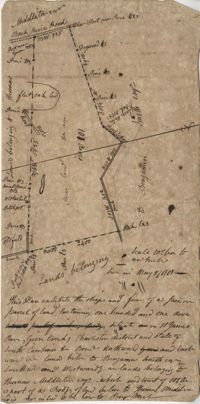
Tract of 514 acres of land conveyed by John Colleton to John Giles May 24, 1777. Bounded on all sides of Fairlawn Barony. Names associated with this plat are John Colleton, John Giles and Fairlaws. Notable geographic locations include Broad Road and Fairlawn.
161 acres of land southeast of Pee Dee River. Details include rivers, a canal, and trees. Names associated with this plat are Mackie and William Stitt. Notable geographic locations include Waccamaw River and Pee Dee River.
Tract of land belonging to May Ball in area known as Three Mile Head. Names associated with this plat are John Ball, Huger, Gourdin, E. Ball, May Ball and Caw. Notable geographic locations include Three Mile Head and Tartleberry.
Tract of land containing 416 acres. Details include trees, surrounding land, water, and roads. Notable geographic locations include St. John's Parish and Berkeley.
200 acres located in Colleton County on the north side of Colleton River. There is a note stating that Samuel Lowall was also granted 200 acres "situated on this side or here, dated 19th Feb. 1711." Names associated with this plat are Robert Gibbs, Samuel Lowall, Charles Parker and James Cockran. Notable geographic locations include St. Paul's Parish, Colleton River and Colleton County.
35 acres granted to John Izard in September of 1766 then sold to William B. Mitchell. Names associated with this plat are John Izard, William B. Mitchell, William Cattle, Isaac W. Mcpherson, James Brisbans, Mep Martha Miles, Samuel Wainwright, Gum Huhy [?], William Sanders. Notable geographic locations include St. Paul's Parish.
Plat of 500 acres off of the Savannah River granted to James Sutherland in 1737. Detail includes a creek of the southern branch of the Savannah River and various trees on the property lines. Names associated with this plat are James Sutherland, Patrick McKay, and James Stobo. Notable geographic locations include St. Peters Parish, Savannah Lands, and the South Branch of a creek of the Savannah River.
John Grigg 69 Acres Certified for him Feb 28th 1793. John Grigge 69 acres recorded 24 September 1793. Names associated with this plat are John Grigg, William Jones, William Burens, Crompton, H. J. [?] Kennedy, Barnes, Bowels, Somes [?] and John Buren. Notable geographic locations include Fairfield County, Camdon [Camden?] District, and Sawines [?] Creek.
64 acre plot of land on the north side of the Ashley River, notes on the plat include some notes about stocks, shows surrounding tracts of lands, no land type or detail. Names associated with this plat are William Fuller, John Johnson, James Simmons, Stocks, William Fuller, George Smith, Henry Wood and John Hewson.
150 acre plot budding and bounding on the east side of the Edisto River, shows south Edisto River and surrounding plot owners, no land detail. Names associated with this plat are John Gerardeau, William Livingston, Charles Gruren, and Thomas Broughton. Notable geographic locations include South Edisto River and Colleton County.
Plat includes 110 acres sold to Hugh Rutledge and surrounded by other properties owned by him. Property sold to Rutledge in July of 1791. Names associated with this plat are Hugh Rutledge, Charles Pinckney, and James Stanyuin [?].
Copy of a plat of 150 acres and granted to Jobe Howes now forming part of Hickory Hill plantation in St. James Goose Creek and part in St. John and St. James Parish.
Plat of a part of Inverness sold from the estate of C. Huguenin to John Martin containing 538. Plat includes a railroad, a fort, a public road and fence. Names associated with this plat are C. Huguenin, John Martin, William Heyward, and Gunie [?]Williams. Notable geographic locations include Inverness and Pocotaligo Bridge.
400 acres of land once owned by James Wrixon, then Purchas Morgan, and then Henry Webster who conveyed the land to Ezekiel Branford and Christopher Peters. 250 acres came to the ownership of Ezekiel Branford (N1 and N2) and the remaining 150 acres owned by Christopher Peters (N3). The dates of purchase can be found on the plat. The lands contain pine, gum, cypress, white oak and hickory trees. The lands lie to the east of the Ponpon River. Names associated with this plat include Henry Webster, James Wrixon, Ezekiel Branford, Christopher Peters, Purchas Morgan and Alexander Watkin.
1000 acres granted to Elizabeth Jennings situated in Craven County about 14 miles above Lynch's Creek Ferry, about 3 miles below lands of Joseph Birch. Bounding to the SW on Pee Dee River, NW on John Stone's land, and on all other sides on lands not yet laid out. Names associated with this plat include A. Vanderhorst, Stone, Elizabeth Jennings, Elizabeth Raven, John Stone, George Pawley, Joseph Birch, Jasper St. John, Miniken and Hamilton. Notable geographic locations include the Pee Dee River, Craven County [now in parts of Berkeley, Charleston, Georgetown, and Williamsburg counties], and Lynch's Creek Ferry.
187 acres of land laid out for Walter Izard in Berkeley County butting and bounding North and West on lands of Francis Varnod, South on Thomas Waring lands and East on George Boons land. Names associated with this plat are Francis Varnod, Thomas Waring, Joseph Boone, Walter Izard, James St. John, and Robert Johnson. Notable geographic locations include St. George's Parish, Dorchester and Berkeley County.
True copy of a plan surveyed for an inland plantation for Breton Singletary containing 500 acres situated in Craven County butting and bounding northerly on late William North, southerly by Singletary and all other sides on lands not yet laid out. Names associated with this plat are Thomas Broughton, Breton Singletary, Richard Beresford, William North, Charles Craven, Alexander Heward, John St. Martin, Thomas Valley, Mary Henry, and Robert Smith. Notable geographic locations include Wambaw, St. Thomas Parish, and Craven County [now in parts of Berkeley, Charleston, Georgetown, and Williamsburg counties].
Plat of two tracts of land one for 360 acres and the other for 90 plat contains dates and names of the properties as well as a short chain of title. Names associated with this plat are John Musgrove, John Champneys, Sarah Champneys, William Stend, Robert Adams, George Jackson, Thomas Grumball, Sherriff C.D Elliott, Jabina, Col. William Ball, William John Champney, William Seads, and James St. John. Notable geographic locations include the Edisto River, Hickory Bridge and Colleton County.
3.71 Acres of highland near marsh adjacent to Meeting Street Road. Names associated with this plat are Karl W. Ruth, A.F.C. Kramer, and S. Louis Simons.
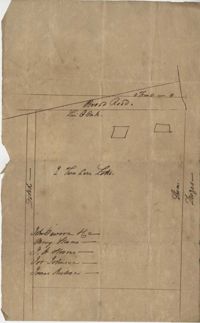
Sketch of lots near Dorchester now belonging to James Kennedy. Names associated with this plat are James Kennedy, Thomas Droger, John Dawson, M. Strom, J.H. Strom, J. Johnson, and J. Nilson. Notable geographic locations include Dorchester, St. George's Parish and Broad Road.
Plat of land belonging to Thobar butting and bounding 163 acres of land owned by Margaret Burger Master. Very little explanation of pertinent details on the plat. Names associated with this plat are Henry Thobhar, Margaret Burger Master, N. Winklin and J.L. Porcher.
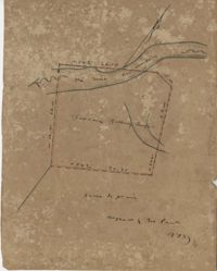
Plat contains 420 acres But is to the estate of Fulmer and Shubrick and to Shubreek and Hewart also bounding to Hapensack and Izard. Plat includes the location of the house and paths connecting the property to its neighbors. Names associated with this plat include William Conrade Heekeley, Shubrick, Fulmer, Hewart, Hapensack, Ralph Izard, and Thomas Abernethie. Notable geographic locations include St. James Parish, Goose Creek, Wolf Castell, Berkeley County, and Charleston District.
Plat of 42 acres in St. George’s Parish belonging to Nathaniel Bradwell. Very little detail included with the plat. Names associated with this plat include Nathaniel Bradwell, John B. Giradeau, E.G. Montagu, John Barker, and Peter Haskins.
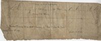
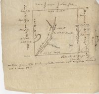
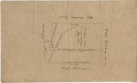
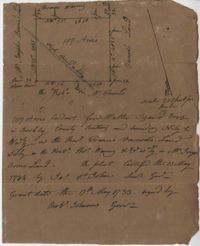
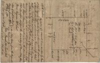
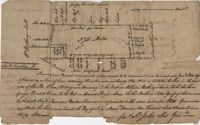
Plat of 250 acres of land granted to Bonam Sam on Wadmalaw Island the 5 May 1704. Names associated with this plat are Sam Bonam, William Lowry, Henry Livingston, and Thomas Stangarn.
Plan of the old field tract in St. John's Parish late belonging to Francis Huger now to John Ball. Compiled and copied from original papers. Names associated with this plat are James Child, Francis Huger, John Ball, James Child, William Walter [?], Nathaniel Johnson, John Archdale, Thomas Droughton, P. Pawley, J. Child and Hentey [?].
Plat contains 700 acres in Colleton County on the north side of Round O Savannah. Grant dated September 30, 1736. Names associated with this plat are Robert Bath, James St. John, James Ferguson and Peter Bremar. Notable geographic locations include Colleton County and St. Bartholomew's Parish.
Plat is laid out for 200 acres of land but when surveyor toured the land contained 547 acres apparently the surveyor did not "run the lines" properly when the land was first laid out and not setting corners. Names associated with this plat are Thomas Tucker, Archibald Crall, John Cook, Richard Ireland, Levey, John Linder, and James Stuard. Notable geographic locations include the Edisto River.
Plat of land belonging to General Cuthbert in the Beaufort District on the Pocotaligo River. Little other detail included in the plat besides the property lines, trees and the river. Names associated with this plat are Cuthbert Luna, Smith, Gordon [?], and Adam Jordan.
Plat laid out unto James St. John containing 375 acres of land in Colleton County. Names associated with this plat are James St. John, William Westbury, George Vincent, Samuel Sleigh, and John Godfrey. Notable geographic locations include Colleton County and the Pon Pon River.
Copy of a plat of 490 acres owned by Francis Smith annexed to the lands owned by Laughlin McIntosh. Names associated with this plat are Francis Smith, Laughlin McIntosh, Beadon Colonel, Captain Hutchinson, and Thomas Fleming. Notable geographic locations include St. Bartholomew's Parish, Chickaw and Charleston District.
Copy of plat of 342 acres on Johns Island. Very little detail, just an outline of the property with trees on the edges. Names associated with this plat are Thomas Ladson, Hanscome, Allen, William Wallisby, Robert Murens, and Brocher. Geographic locations are the Stono River, Colleton County and Johns Island.
Copy of a plat granted to Abraham Michau north side of Santee and containing 213 acres in the Georgetown district in Craven County [now in parts of Berkeley, Charleston, Georgetown, and Williamsburg counties]. Names associated with this plat are Abraham Michau, James St. John, Thomas Broughton, Paul Michau, and John Dear.
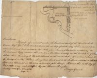
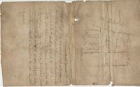
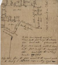
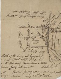
Sketch of the survey ad laying out of a small tract called Red Branch on the west side of the Cooper River containing 6 acres lately sold by Middleton to Leval part of 400 acres tract granted to Dr. Snow. Names associated with this plat are Peter Pamplat, Peter Gray, Snow, and Middleton.
Plat of 222 acres granted to and acquired by Elias Horry on the Santee River. Names associated with this plat are Elias Horry and Izard. Names associated with this plat are Elias Horry and Izard. Notable geographic locations are Santee River, Toby Creek, Wild Hook Creek.
Plat of 100 acres of land conveyed by William Norman to Edward Keating situated at Goose Creek. Names associated with this plat are Edward Keating, William Norman, John Bayly, and Moultrie. Notable geographic locations are Goose Creek.
Plat of 4883 acres belonging to Thomas Smith. Very little detail, only the outline of the property is included. Names associated with this plat are Thomas Smith, General Oglethorpe, Smith, Thomas Elliott, Hugh Bryan, and Allen. Notable geographic locations include Granville.
Copy of plat of 230 acres granted to Bryan Presly in Colleton County on Pon Pon River. Names associated with this plat are Bryan Presly, and John Bull, and Hendrich. Notable geographic locations include Pon Pon River and Colleton County.