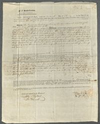
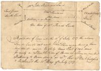
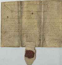
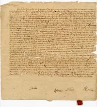
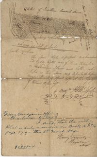
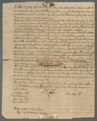
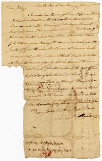
A land indenture from Ann Ferguson and Judith Wragg, representatives of the deceased John Wragg, in which they agree to sell John Wragg's estate on the Charleston Neck to John Ball Jr.
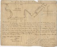
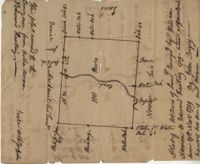
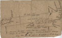
Sipros Openen Plantation, 342 acre plantation in Colleton county near Stono River, an island plantation, shows property lines and no land detail, also shows surrounding area outside of the plantation. Names associated with this plat are William Willersby, Alens [?], Thomas Lattson, Robert Murens, Ambers Helle, Charles Craven, Hells and Thomas Broughton. Notable geographic locations include Colleton County, Stono River, Sipros Opener, and Johns Island.
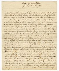
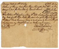
A land conveyance of a plantation to Elias "Red Cap" Ball in Berkeley County. The conveyance grants Elias Ball and his family freedom of "hawking, hunting, fishing & fowling" on the property.
150 acre plot budding and bounding on the east side of the Edisto River, shows south Edisto River and surrounding plot owners, no land detail. Names associated with this plat are John Gerardeau, William Livingston, Charles Gruren, and Thomas Broughton. Notable geographic locations include South Edisto River and Colleton County.
500 Acre plantation, on the northeast side of the south Edisto River, neighbors the 416/2-13 plat, the 416/2-13 is added in pencil over the writing at the bottom of the plat, no land type or detail. Names associated with this plat are John Gerardeau, Charles Craven, William Livingston, Thomas Broughton, and Charles Parker. Notable geographic locations include South Edisto River and Colleton County.
Copy of plat of 342 acres on Johns Island. Very little detail, just an outline of the property with trees on the edges. Names associated with this plat are Thomas Ladson, Hanscome, Allen, William Wallisby, Robert Murens, and Brocher. Geographic locations are the Stono River, Colleton County and Johns Island.
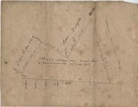
180 plot of land given to Elisa [Pennison], shows the budding and bounding of neighboring plantations with no land type or detail. Names associated with this plat include Thomas Pennison, Elisa Pennison, C. Perriman, Thads, Smith and Charles Grady.
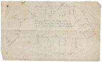
Plat of 88 acres near Stono Island in Colleton County. Little detail drawn into the plat. Names associated with this plat are Francis Hoxt, Stanyard, and Hock.
Plat of 100 acres of land conveyed by William Norman to Edward Keating situated at Goose Creek. Names associated with this plat are Edward Keating, William Norman, John Bayly, and Moultrie. Notable geographic locations are Goose Creek.
1770-1779, 1760-1769, 1740-1749, 1750-1759, 1720-1729, and 1730-1739
Description:
The Ball Family Account and Blanket Book, 1720-1778, includes lists of purchases, expenses, blankets given out to enslaved persons, and names/ages of enslaved persons at Midway, Limerick, Comingtee and Kensington Plantations. The book includes a loose list of enslaved men with their place of birth and ages, ca. 1750, currently on exhibit at the South Carolina Historical Society Museum.
Copy of "An Additional Act for the Better Regulation of Indian Trade-Appointment of Commissioners of Indian Trade." This act was presented by James Moore at the Charlestown Council Chamber. The document refers to the success of this trade regulation based on the behavior of the "Indian traders" and "several nations of Indians in amity with the government." Makes notation about "restraining the abuses committed to the said traders among the said Indians..." appointing commissioners for "better regulation of the Indian trade" and the oaths these men must take. The Native Americans mentioned in the document are the "Northward Indians," or the Catawba. Makes notation that there is no direct or indirect trading with the Cherokees.
156 acres laid out to John Bayly and granted to the said John Bayly in 1698 in Colleton County. Names associated with this plat are George Mitchell, John Bayly, and John Andrews.
A land indenture of two Childsbury Town lots conveyed to Isaac Child by John Skinner for forty-six pounds. The two properties are located near Mulberry Street and Church Street. The second page of the indenture is a statement by Mary Skinner agreeing to the release of these properties to Isaac Child.
The last will and testament of John Ashby in which he divides his estate among his family. John Ashby leaves his wife Elizabeth an enslaved woman named "Soua" and her two children, Quash and Hannah.
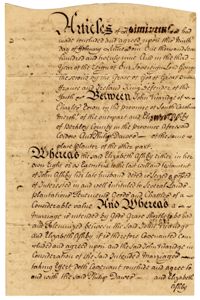
Articles of Agreement between Elizabeth Ashby, John Vivaridge, and Philip Dawes in which widow Elizabeth Ashby, is marrying John Vivaridge. The document discusses Elizabeth Ashby's debts, estates and enslaved persons.
This is the diary of Henry Ravenel (1729-1785); Ren?? Ravenel 1st (1762-1822); and Henry Ravenel (1790-1867) concerning the years 1731-1860. It covers subjects such as births and deaths of family and slaves; illness; finances; farming rice, corn and indigo; slavery; weather observations; the American Revolution; and building projects. A span of 54 blank pages in the middle of the document is represented by a single image. Further, the latter half of the document appears flipped 90 degrees in the original document but has been rotated for easier online viewing.
Plat consists of 4,000 acres in St. Peter’s Parish belongs to Joseph Blake granted July 1731. Names associated with this plat are Joseph Blake, Horrey and Stevens. Notable locations include St. Peter's Parish, Savannah River and Savannah Path.
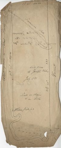
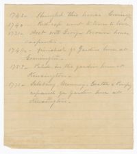
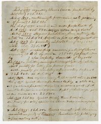
A record of tasks completed between 1731-1771 that includes placing shingles on the house at Comingtee Plantation, accounts with carpenters and work on the gardens at Comingtee and Kensington Plantations. Makes notation that the enslaved persons Salsbury, Manny, Easter and Pompey worked on the garden at Kensington Plantation.
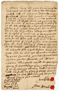
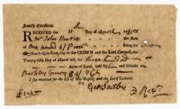
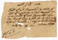
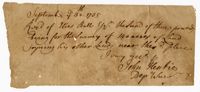
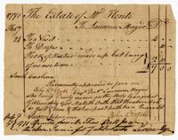
A receipt from Saxby stating that John Hentie paid one pound for two years "Quit-rent "due to the crown, and paid the Lord Carteret for three hundred acres of land.
1100 acres of land belonging to Thomas Woodward on the east and west side of Fish Pond Creek known as Ashepoo River. Names associated with this plat are Thomas Woodward, Elizabeth Woodward, James St. John, Billinger, and Blaky, and William. Notable geographic locations include Ashepoo River and Fish Pond Creek.
650 acres belonging to Thomas Cordes on eastwest side of Fishpond Creek/ Ashepoo River bounding northwest on Elizabeth Woodward and south by Captain John Gibbes. Names associated with this plat are Thomas Cordes, Elizabeth Woodward, Captain John Gibbes, and Robert Johnson. Notable geographic locations include Fishpond Creek, the Ashepoo River and St. Bartholomew's Parish.
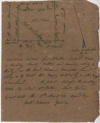
Plat contains 700 acres in Colleton County on the north side of Round O Savannah. Grant dated September 30, 1736. Names associated with this plat are Robert Bath, James St. John, James Ferguson and Peter Bremar. Notable geographic locations include Colleton County and St. Bartholomew's Parish.
Copy of plat of 230 acres granted to Bryan Presly in Colleton County on Pon Pon River. Names associated with this plat are Bryan Presly, and John Bull, and Hendrich. Notable geographic locations include Pon Pon River and Colleton County.
340 acres of land laid out to George Mitchell on the east side of a branch of Ashepoo River called the Horseshoe Creek. Names associated with this plat are George Mitchell, James St. John, Thomas Broughton and John Andrews. Notable geographic locations include the Ashepoo River and Horseshoe Creek.
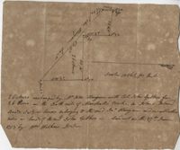
64 acre plot of land on the north side of the Ashley River, notes on the plat include some notes about stocks, shows surrounding tracts of lands, no land type or detail. Names associated with this plat are William Fuller, John Johnson, James Simmons, Stocks, William Fuller, George Smith, Henry Wood and John Hewson.
Elias Horry's 454 acre plot in the St. James parish near the Santee River, shows property boundaries, no details on the property or type of land. Names associated with this plat include Elias Horry, Daniel Horry and A. Bonneau.
960 acres of land situated lying and being in Colleton County, butting and bounding to the north on part of John Seabrook's land to the east on Ashepoo River to the South on land of Captain Thomas Flemming and part of John Dears’ Land. Names associated with this plat are Benjamin Whitaker, Thomas Pinckney, Captain Thomas Flemming, John Seabrook, John Dear, Richard Woodward, John Hutchinson, John Godfrey, Samuel Larrington, James St. John, Godfrey, Elizabeth Woodward, William McPherson, Thomas M. Pinckney, and James M. Pinckney. Notable geographic locations are Ashepoo River, Dear's Creek and Colleton County.
Two small plats of land. One containing 200 acres of land laid out to Margaret Childs situated near the head of Weetee Branch. Bounding on the NE, NW, and SE, and West on vacant lands. Southwestardly on land formerly laid out to Daniel Gibbons. The second plat is 78 acres of land laid out to Robert Newman in Craven County bounding to the north of Orochone [?] and on all other sides by vacant land. Names associated with this plat are Daniel Gibbons, Robert Newman, James St. John, Thomas Broughton, and Margaret Childs. Notable geographic locations include Prince Frederick’s Parish, Georgetown district, Weetee River, and Christal [Crystal?] Spring.
1000 acres granted to Elizabeth Jennings situated in Craven County about 14 miles above Lynch's Creek Ferry, about 3 miles below lands of Joseph Birch. Bounding to the SW on Pee Dee River, NW on John Stone's land, and on all other sides on lands not yet laid out. Names associated with this plat include A. Vanderhorst, Stone, Elizabeth Jennings, Elizabeth Raven, John Stone, George Pawley, Joseph Birch, Jasper St. John, Miniken and Hamilton. Notable geographic locations include the Pee Dee River, Craven County [now in parts of Berkeley, Charleston, Georgetown, and Williamsburg counties], and Lynch's Creek Ferry.
Plat of 222 acres granted to and acquired by Elias Horry on the Santee River. Names associated with this plat are Elias Horry and Izard. Names associated with this plat are Elias Horry and Izard. Notable geographic locations are Santee River, Toby Creek, Wild Hook Creek.
Plat contains 200 acres conveyed to Thomas McConnell of W town 1814. Granted to Duyal Mckechaw in 1735. Names associated with this plat are Thomas McConnell, Duyal Mckechaw, John Summerhoofs, Eliza Staufiur, and John White.
Copy of plat granted to John Atchison. "The plat annexed to the grant dated March 2, 1736." Names associated with this plat are John Atchison, James St. John, Thomas Broughton, J. Branch and Middleton. Notable geographic locations include Santee, Four Mile Creek, Santee River, and Cravens County [now in parts of Berkeley, Charleston, Georgetown, and Williamsburg counties].
187 acres of land laid out for Walter Izard in Berkeley County butting and bounding North and West on lands of Francis Varnod, South on Thomas Waring lands and East on George Boons land. Names associated with this plat are Francis Varnod, Thomas Waring, Joseph Boone, Walter Izard, James St. John, and Robert Johnson. Notable geographic locations include St. George's Parish, Dorchester and Berkeley County.
Plat of 500 acres off of the Savannah River granted to James Sutherland in 1737. Detail includes a creek of the southern branch of the Savannah River and various trees on the property lines. Names associated with this plat are James Sutherland, Patrick McKay, and James Stobo. Notable geographic locations include St. Peters Parish, Savannah Lands, and the South Branch of a creek of the Savannah River.
The will of John Gough which includes the sale of land to pay off debts and the division of his enslaved persons. Three enslaved men named Little Quash, Hercules and "Bruker" are left to his son Richard, one enslaved girl named "Jubah," daughter of Silvia" to his son Edward, two enslaved women named Phillis and Jubah's children Hannah and Billy to his son Neal and one enslaved girl named Betty to his son Francis.
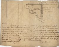
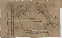
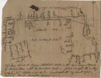
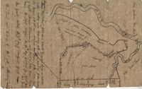
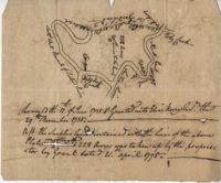
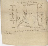
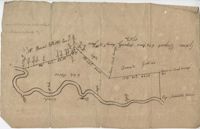
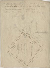
600 acres plot granted to Richard Floyd residing in Colleton County lying and budding on the southside of Bohickett Creek, shows surrounding property names and creeks, shows land notes but no land type or details. Also shown is 200 acres granted by the Lords Proprietors by William Arnell in Colleton County. Names associated with this plat are Richard Floyd, Graeme [?], the Lords Proprietors, Michael Ranell, Thomas Broughton, Robert Gibbes, William Atnel, Timothy Bellemey, Anthony Matthews, Ambross Hill, John Prescot and Neufville. Notable geographic locations include John's Island, Bohickett Creek, Colleton County, Ambrose Hill, Stono River, and Keywa [Kiawah] Island.
Copy of a plat of land in St. Andrew’s Parish, 103 acres are marsh land. Little other detail or explanation. At the time of the copy belonged to George Wagner. Names associated with this plat include Stephen Bull, Thomas Jones, George Wagner, Richard Godfrey, Nathaniel Brown and Thomas Jones.
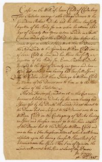
A case concerning the will of James Child for property left to his grandson Robert Dicks. Upon the death of Robert Dicks, the property was then given to James Child's other grandson William Child.
Plat of 500 acres in Colleton County. Very little detail included. Names associated with this plat are Alexander French, Thomas Clifford, Bettison, Francis Young, George Hunter, and John Bartys.
The last will and testament of William Allston in which he divides his estate among his family. Included in the will are the divisions of enslaved persons. The names of the enslaved persons given to individual family members are Anode, Bess, Little Bob, Ceasar, Charity, Charles, Clarandon, Dick, Dinah, Fillis, Friday, Guy, Hagar, Hercules, Jack, Jenny, Jimmy, Josey, Lucy, Mariah, Mingoe, Pegg, Peter, Phiney, Primus, Rose/Little Rose, Sam, Sandy, Snow, Titus, Toney, Violet and Winter.
The Foaling Register, 1745-1777, is a bound register kept by Elias Ball II recording the selling and purchasing of horses, mules and mares and the births of colts at Kensington and Limerick Plantations.
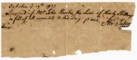
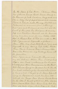
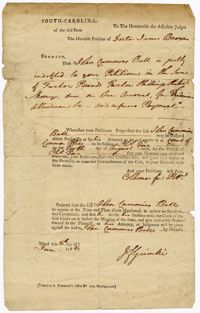
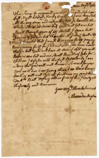
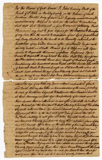
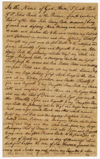
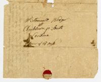
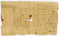
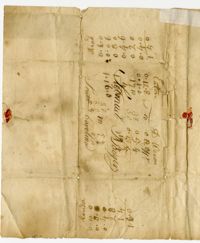
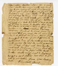
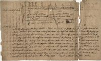
A petition by Dorta James Brown to John Coming Ball in which she petitions to have Ball appear before the Court of Common Pleas for twelve pounds and twelve shillings that he refuses to pay. The petition states that the money is for medical attendance.
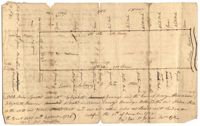
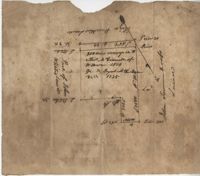
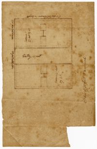
FRONT: Plat is on the northside of the Ashley River. Contains 200 acres. BACK: Plat contains 36 acres on the North side of the Ashley River. Names associated with this plat are Richard Baker, Elibee Baker, John Baker, Josiah Baker, John Guptan, James Cantley [?], James Glen, John Stevens, Joseph Child, John Ainslee, Richard Baker, William Cattell and George Hunter. Notable geographic locations include St. George's Parish, Ashley River and Berkeley County.
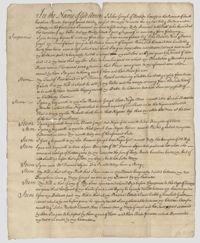
The last will and testament of Elias Ball I in which he leaves Comingtee Plantation to his son Elias Ball II, tracts of land referred to as Dockum Plantation, land known as "Eveleigh's Land," the enslaved man "Sambo" and Lot No. 49 in Charlestown to his son John Coming Ball, money and the remainder of a lot in Charlestown to his daughter Eleanor Laurens, and a pew to his children at St. Phillips Church.
Plat includes 624 acres surveyed for Gideon DuPont. Plat does not contain structures. Names associated with this plat are Gideon DuPont, William Thomas Elliot, Captain Daniel Godin, and Middleton. Notable geographic locations are St. Bartholomew's Parish, the Ashepoo River and Deer Creek.
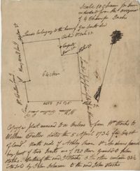
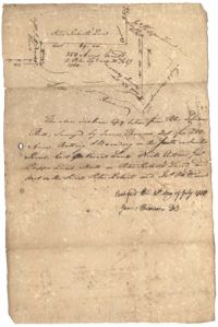
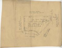
26 acres of land exchanged by John Stanyarn with Col. John Gibbes in the north side of Marshall's Creek on John's Island. Bounding on the south on lands belonging to the said Stanyarn and on all other sides on lands of John Gibbes. Laid out in 1753. Names associated with this plat are John Stanyarn, John Gibbes and Wilkins. Notable geographic locations include Johns Island and Marshall's Creek.
The Charles Pinckney Account Book, 1753, is an account book that includes rental rolls, listings of slaves, lists of titles, acreage allotments and deeds of real estate. Many of the slaves referenced in the account book are listed by first name, their slave family as well as their age.
Plat of 163 acres in the St. George District. Very little detail or explanation provided on the plat. Names associated with this plat are David Run, John Woodrich, Elibu [?] Baker, John Drayton, and B. Wood [?]. Notable geographic locations include St. George Parish and St. George District.
Receipt book kept by Eliza L. Pinckney includes formulas for making medicines to treat croup, fever, dropsy, and other conditions; recipes for cheese cake, puddings, currant wine, orange marmalade, jelly, oyster soup, and other foods; instructions for preparing meats and rice, and preserving and pickling foods; and a formula "To make the hair grow."
Plat of 300 acres in Berkeley County. Very little detail included in the plat. Names associated with this plat are James McKelvey, John Evans and Sarah Vance. Notable geographic locations include Berkeley County and Russells Creek.
250 acre plot given to Peter Lesesne on the 20th of February 1760, butting and bounding on the south side of the Santee River. Names associated with this plat are Peter Lesesne, James Thomson, Peter Robert, Joseph Manap [?], and Phippes.
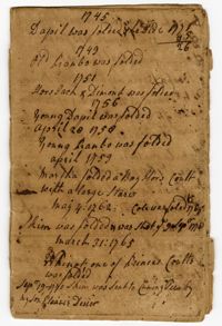
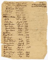
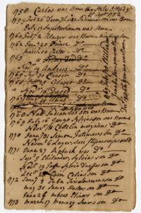
A list of enslaved children born between 1758-1817. Information includes the name of the enslaved child, their date of birth and occasionally, the name of their mother and father.
A list of enslaved children born between 1758-1763. Information includes the name of the enslaved child, their date of birth and occasionally, the name of their mother and father.
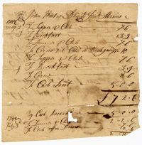
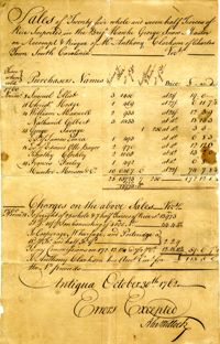
An account of the "Sales of twenty-five whole and seven half tierces of rice imported in the brig Hawke...on account and risque of Mr. Anthony Clarkson of Charles Town South Carolina."
Plat of 300 acres in St. Andrew’s Parish on the Stono River originally granted to William Branford. At the time of the copy it belonged to George Wagner. Names associated with this plat are William Branford, George Wagner, Egerton Leigh, Thomas Boone and Elizabeth Hutchins.
1000 acres of land laid out for Peter Sinclair in St. James Parish, Santee. Names associated with this plat are Peter Sinclair, Susannah Lowndes, Peter Morison, Dupree, Richard Wither and Lewis Morison.
The last will and testament of John Coming Ball in which he leaves his plantation and other purchased land to his son Elias Ball, money for his daughters Elizabeth and Catharine, six hundred pounds "in lieu of two negros," tracts of land called "Three Mile Head" to Elias and John Ball, acres of land and "oak and hickory land" to his daughter Jane Ball. John Coming Ball leaves his wife Judith Ball tracts of land, horses, furniture and a "wench called Molly and her son." Makes notation on the division of enslaved persons among the Ball children. The enslaved persons are referenced as "Monimias" daughter Sally, a girl called Senah, Marcus, a girl called Silvia, and a boy called Pino. Makes a statement that the enslaved man and driver Sambo is to be free upon the death of John Coming Ball, given money yearly and is allowed to live on any plantation under the ownership of the Ball family.
A copy of the last will and testament of Judith Ball in which she leaves furniture and other household items to her son John Ball, her china table and china set to her daughter Jane Ball, an enslaved man named Jacob, one "negro wench" Rinah" and one other "wench named Violet" money and furniture to her daughter Eleanor Ball, a horse to her son-in-law Elias Ball and money to her niece Esther Roberts.
A copy of the last will and testament of Lydia Child Ball in which she states to "give and dispose of all such slaves & there respective issue," a bond of one thousand pounds to John and Nicholas Harleston, the enslaved man Ratcliffe and the enslaved women Amey to her daughter Catherine Simons, the enslaved man Sam to her son and a list of executors she appoints to carry out her will.
A land conveyance of one-sixth part of 840 acres from Elias Ball II and Lydia Simons Ball to their daughter Catherine Simons. This conveyance includes "all the houses, outhouses, woods, underwoods, timber and timber trees…" found within this portion of land.
The Surveyor's Notebook, 1767, is a bound volume kept by or for a member of the Ball family containing field notes, tables, conversions of liquid, cloth measures, and a description of rules of "three direct" and "three inverse."
Plat of 1000 acres is surrounded by vacant land. Names associated with this plat are John Stuart. Notable geographic locations include Berkeley County and St. Stephen's Parish.
True copy of Peter Sinkler plat contains 310 acres in Craven County [now in parts of Berkeley, Charleston, Georgetown, and Williamsburg counties] bounding northwest on land of Isaac Porcher and Rene Pyre, southeast on land of Robert Taylor and Rene Ravenel, and northwest on Santee River. Names associated with this plat are Peter Sinkler, Robert Taylor, Ephraim Mitchell, Rene Pyre, Isaac Porcher, Rene Ravenel, John Brernon, and Henry Mowlon. Notable geographic locations include St. James Parish, the Santee River and Craven County.
Plan of a tract of 1000 acres of land in Wall Eye Swamp in Craven County [now in parts of Berkeley, Charleston, Georgetown, and Williamsburg counties]. Names associated with this plat are Samuel Cooper, James Sinkler, Peter Sinkler, Isham Moore, John Bremar, and William Bull.
Plat of 4883 acres belonging to Thomas Smith. Very little detail, only the outline of the property is included. Names associated with this plat are Thomas Smith, General Oglethorpe, Smith, Thomas Elliott, Hugh Bryan, and Allen. Notable geographic locations include Granville.
A letter written by Elias Ball II to his brother John Ball at Kensington Plantation discussing travel, jackets and hiring a doctor for a medical opinion.
Plat of 500 acres granted to Robert Cahousac January 10,1771. Names associated with this plat are Robert Cahousac, Samuel Cooper, Gabriel Gigneliat [?], Mitchum, Witten, Zachariah Villeponteux, William Mazyck, Juxbury Lumber Co, William Washington, and Charles Parker. Notable geographic locations include St. Bartholomew's Parish and Charleston County.
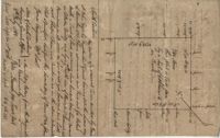
400 acres of land once owned by James Wrixon, then Purchas Morgan, and then Henry Webster who conveyed the land to Ezekiel Branford and Christopher Peters. 250 acres came to the ownership of Ezekiel Branford (N1 and N2) and the remaining 150 acres owned by Christopher Peters (N3). The dates of purchase can be found on the plat. The lands contain pine, gum, cypress, white oak and hickory trees. The lands lie to the east of the Ponpon River. Names associated with this plat include Henry Webster, James Wrixon, Ezekiel Branford, Christopher Peters, Purchas Morgan and Alexander Watkin.
The Account Book of Enslaved Persons Belonging to Henry and Rene Ravenel, 1771-1867 records the enslaved children born under the ownership of Henry or Rene Ravenel. The lists include the first name of the child, their parents, date of birth and occasionally includes notes of death or if purchased by another slave owner. This book contains a second use written upside down and back to front.
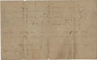
"Plan of a Plantation containing 240 acres in St. Andrew’s parish belonging to William Newbenny. Surveyed by N. Brandwill March 1772. Copy taken from the plan in the property of William Newbenny." The plat also contains the location of a structure and a road leading to it. Plantation located on East side of Ashley River. Names associated with this plat are William Mewhening, N. Brandwill, Whitenarth Tuller, William Scotts, Ralph Izard, the Lords Proprietors, William Williams and William Scott.