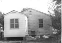
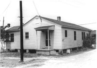
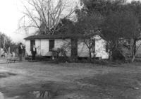
House (rear view) on site affected by the construction of Interstate 26 (I-26). Address: 2122 Weaver Avenue. Surveyor notations on back of photo: "Dkt.: 10.490. Property owner: Olar C. Verdier [Ola C. Verdier]. Tract: 189. Station: 35' Lt. Sta. 5887+45. Date: May 15, 1962. In R/W - Bought." [See collection description for explanation of surveyor notations.]
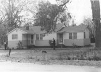
House (rear view) on site affected by the construction of Interstate 26 (I-26). Address: 2119 Weaver Avenue. Surveyor notations on back of photo: "Dkt.: 10.490. Property owner: Marion Butler, et al. Tract: 192. Station: 5888+50 on CL. Date: May 15, 1962. In R/W - Bought." [See collection description for explanation of surveyor notations.]
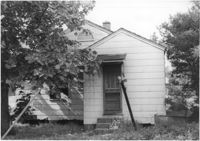
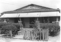
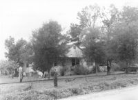
House on site affected by the construction of Interstate 26 (I-26). Address: 2124 Weaver Avenue. Surveyor notations on back of photo: "Dkt.: 10.490. Property owner: Harry L. Rumph, Jr. Tract: 188. Station: 5887+20 on CL. Date: May 15, 1962. In R/W - Bought." [See collection description for explanation of surveyor notations.]
House on site affected by the construction of Interstate 26 (I-26). Address: 2124 Weaver Avenue. Surveyor notations on back of photo: "Dkt.: 10.490. Property owner: Harry L. Rumph, Jr. Tract: 188. Station: 5887±00 Lt. Date: August 29, 1962. In R/W - Bought." [See collection description for explanation of surveyor notations.]
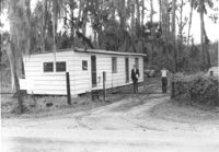
House on site affected by the construction of Interstate 26 (I-26). Address: 2126 Weaver Avenue. Surveyor notations on back of photo: "Dkt.: 10.490. Property owner: J.L. Duffy. Tract: 187. Station: 5887±00 Rt. Date: August 29, 1962. In R/W - Bought." [See collection description for explanation of surveyor notations.]
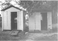
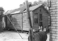
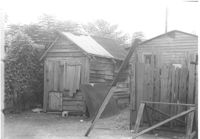
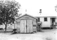
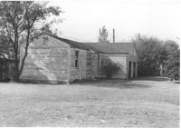
Two sheds on site affected by the construction of Interstate 26 (I-26).Address: 2124 Weaver Avenue. Surveyor notations on back of photo: "Dkt.: 10.490. Property owner: Harry L. Rumph, Jr. Tract: 188. Station: 5887±00 Lt. Date: August 29, 1962. In R/W - Bought." [See collection description for explanation of surveyor notations.]
House (rear view) on site affected by the construction of Interstate 26 (I-26). [Building address number 2209. 2209 Delano.] Surveyor notations on back of photo: "Dkt.: 10.490. Property owner: Dantzler H. Gardner, Est. Tract: 81. Station: 5824+00 Lt. Date: March 22, 1962. In R/W - Bought." [See collection description for explanation of surveyor notations.]
House associated with Francis Brown Methodist Church, on site affected by the construction of Interstate 26 (I-26). Surveyor notations on back of photo: "Dkt.: 10.490. Property owner: Francis Brown Meth. Church. Tract: 52. Station: 5800+20 Lt. Line 'F'. Date: September 12, 1962. Proximity to rear." [See collection description for explanation of surveyor notations.]
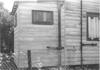
Exterior wall of house on site affected by the construction of Interstate 26 (I-26). Surveyor notations on back of photo: "Dkt.: 10.490. Property owner: William Parineau, et al. Tract: 54. Station: 5800+80 Lt. Line 'F'. Date: September 12, 1962. In R/W - Bought." [See collection description for explanation of surveyor notations.]
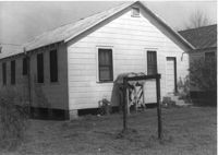
House on site affected by the construction of Interstate 26 (I-26). Surveyor notations on back of photo: "Dkt.: 10.490. Property owner: Lillian Ferguson. Tract: 43. Station: 5799+00 Rt. Line 'G.' Date: September 12, 1962. In R/W - Bought." [See collection description for explanation of surveyor notations.]
House on site affected by the construction of Interstate 26 (I-26). Surveyor notations on back of photo: "Dkt.: 10.490. Property owner: Nathaniel Phoenix. Tract: 46. Station: 5800+00 Rt. Line 'G'. Date: September 11, 1962. In R/W - Bought." [See collection description for explanation of surveyor notations.]
Building (rear view) on site affected by the construction of Interstate 26 (I-26). [Building address number 2015.] Surveyor notations on back of photo: "Dkt.: 10.490. Property owner: Nathaniel Phoenix. Tract: 45. Station: 5799+40 Rt. Line 'G'. Date: September 11, 1962. In R/W - Bought." [See collection description for explanation of surveyor notations.]
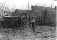
Structure (shed?) in dilapidated condition and wooden fence on site affected by the construction of Interstate 26 (I-26). Surveyor notations on back of photo: "Dkt.: 10.490. Property owner: Nathaniel Phoenix. Tract: 46. Station: 5799+60 Lt. Line 'G'. Date: September 11, 1962. In R/W - Bought." [See collection description for explanation of surveyor notations.]
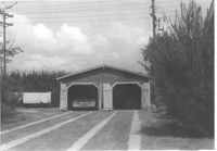
Garage on or in vicinity of King Street Extn., on site affected by the construction of Interstate 26 (I-26). Surveyor notations on back of photo: "Dkt.: 10.490. Property owner: V.C. Chemical Co. Tract: 1. Station: 5807+80 Rt. (Line F). Date: September 11, 1962. In R/W - Bought." [See collection description for explanation of surveyor notations.]
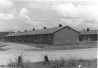
Multi-family housing on Pickens Street (312 Pickens Street), on site affected by the construction of Interstate 26 (I-26). Surveyor notations on back of photo: "Dkt.: 10.490. Property owner: Ashley Development Co. Tract: 1-A. Station: 5769+37 to 5771+00 Rt. Date: September 11, 1962. In R/W - Bought." [See collection description for explanation of surveyor notations.]
House (side view) on or in vicinity of King Street Extn., on site affected by the construction of Interstate 26 (I-26). Surveyor notations on back of photo: "Dkt.: 10.490. Property owner: V.C. Chemical Co. Tract: 1. Station: 5808+50 Rt. (Line F). Date: September 11, 1962. In R/W - Bought." [See collection description for explanation of surveyor notations.]
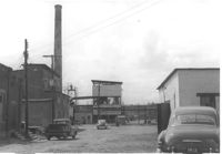
Virginia-Carolina Chemical Corp. building on site affected by the construction of Interstate 26 (I-26). [VC Chemical Corp. was located on King Street Extn.] Surveyor notations on back of photo: "Dkt.: 10.490. Property owner: V.C. Chemical Co. Tract: 1. Station: 5798+20 Rt. Date: September 11, 1962. Wash room. Outside R/W." [See collection description for explanation of surveyor notations.]
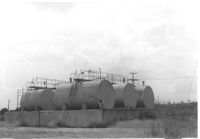
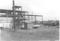
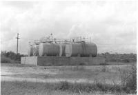
Virginia-Carolina Chemical Corp. tanks on site affected by the construction of Interstate 26 (I-26). [VC Chemical Corp. was located on King Street Extn.] Surveyor notations on back of photo: "Dkt.: 10.490. Property owner: V.C. Chemical Co. Tract: 1. Station: 5803+20 on CL. Date: September 11, 1962. In R/W. Bought. Tank 'farm.'" [See collection description for explanation of surveyor notations.]
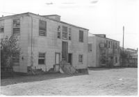
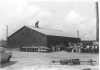
Virginia-Carolina Chemical Corp. buildings on site affected by the construction of Interstate 26 (I-26). [VC Chemical Corp. was located on King Street Extn.] Surveyor notations on back of photo: "Dkt.: 10.490. Property owner: V.C. Chemical Co. Tract: 1. Station: 5798±5799± Rt. Date: September 11, 1962. TCP tower outside R/W." [See collection description for explanation of surveyor notations.]
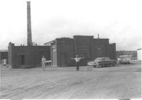
Virginia-Carolina Chemical Corp. structures on site affected by the construction of Interstate 26 (I-26). [VC Chemical Corp. was located on King Street Extn.] Surveyor notations on back of photo: "Dkt.: 10.490. Property owner: V.C. Chemical Co. Tract: 1. Station: 5800+00 Rt. Date: September 11, 1962. To be cut off at R/W." [See collection description for explanation of surveyor notations.]
Virginia-Carolina Chemical Corp. structures on site affected by the construction of Interstate 26 (I-26). [VC Chemical Corp. was located on King Street Extn.] Surveyor notations on back of photo: "Dkt.: 10.490. Property owner: V.C. Chemical Co. Tract: 1. Station: 5800+00 Rt. Date: September 11, 1962. To be cut off at R/W." [See collection description for explanation of surveyor notations.]
Virginia-Carolina Chemical Corp. building on site affected by the construction of Interstate 26 (I-26). [VC Chemical Corp. was located on King Street Extn.] Surveyor notations on back of photo: "Dkt.: 10.490. Property owner: V.C. Chemical Co. Tract: 1. Station: 5798+20 Rt. Date: September 11, 1962. Outside R/W." [See collection description for explanation of surveyor notations.]
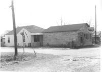
Joe Smith's Grocery, at the corner of Doscher Avenue and Farwell Street, on site affected by the construction of Interstate 26 (I-26). [Building address number 1934.] House to its rear also in photo. Surveyor notations on back of photo: "Dkt.: 10.490. Property owner: Joseph F. Smith. Tract: 21. Station: 5819+00 Rt. Line "G." Date: March 22, 1962. In R/W - Bought." [See collection description for explanation of surveyor notations.]
Joe Smith's Grocery [at the corner of Doscher Avenue and Farwell Street] on site affected by the construction of Interstate 26 (I-26). Building address number 1934. Surveyor notations on back of photo: "Dkt.: 10.490. Property owner: Joseph F. Smith. Tract: 21. Station: 5819+00 Rt. Line "G." Date: March 22, 1962. In R/W - Bought." [See collection description for explanation of surveyor notations.]
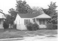
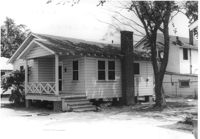
House(rear view) on site affected by the construction of Interstate 26 (I-26). Address: 2171 Heriot Street. Surveyor notations on back of photo: "Dkt.: 10.490. Property owner: Louise S. Carter. Tract: 152. Station: 30' Lt. Sta. 5879+50. Date: May 15, 1962. In R/W - Bought." [See collection description for explanation of surveyor notations.]
House on site affected by the construction of Interstate 26 (I-26). Address: 2171 Heriot Street. Surveyor notations on back of photo: "Dkt.: 10.490. Property owner: Louise S. Carter. Tract: 152. Station: 30' Lt. Sta. 5879+50. Date: May 15, 1962. In R/W - Bought." [See collection description for explanation of surveyor notations.]
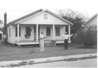
House on site affected by the construction of Interstate 26 (I-26). Address: 3 Carters Court. Surveyor notations on back of photo: "Dkt.: 10.490. Property owner: Louise S. Carter. Tract: 148. Station: 100' Lt. Sta. 5880+25. Date: May 15, 1962. In R/W - Bought." [See collection description for explanation of surveyor notations.]
House on site affected by the construction of Interstate 26 (I-26). Address: 3 Carters Court. Surveyor notations on back of photo: "Dkt.: 10.490. Property owner: Louise S. Carter. Tract: 148. Station: 100' Lt. Sta. 5880+25. Date: May 15, 1962. In R/W - Bought." [See collection description for explanation of surveyor notations.]
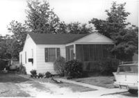
House on site affected by the construction of Interstate 26 (I-26). Address: 2153 Heriot Street. Surveyor notations on back of photo: "Dkt.: 10.490. Property owner: J.C. Locklair. Tract: 147-D. Station: 5879± Lt. Date: august 29, 1962. Proximity." [See collection description for explanation of surveyor notations.]
Two two-story dwellings (rear view) on site affected by the construction of Interstate 26 (I-26). Address: 1317 King Street. Presumably part of the Rose Garden Tourist Court; see I-26 Photo 1467. Surveyor notations on back of photo: "Dkt.: 10.490. Property owner: The Long Corporation. Tract: 200. Station: 5+50 & 6+20 Lt. (Mt. Pleasant Street). Date: September 11, 1962. In R/W - Bought." [See collection description for explanation of surveyor notations.]
Two two-story dwellings (rear view) on site affected by the construction of Interstate 26 (I-26).Address: 1317 King Street. Presumably part of the Rose Garden Tourist Court; see I-26 Photo 1467. Surveyor notations on back of photo: "Dkt.: 10.490. Property owner: The Long Corporation. Tract: 200. Station: 5889+00 to 5890+00 Lt. Date: September 11, 1962. In R/W - Bought." [See collection description for explanation of surveyor notations.]
Garage or shed on site affected by the construction of Interstate 26 (I-26). Surveyor notations on back of photo: "Dkt.: 10.490. Property owner: Joseph F. Smith. Tract: 20. Station: 5819+82 on Lt. of line "G." Date: March 22, 1962. In R/W - Bought." [See collection description for explanation of surveyor notations.]
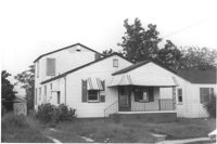
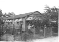
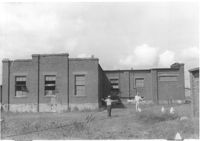
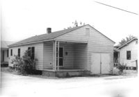
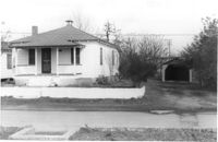
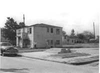
House on site affected by the construction of Interstate 26 (I-26). Building address number 2202. Surveyor notations on back of photo: "Dkt.: 10.490. Property owner: Julius A. Cercoply. Tract: 17. Station: 5818+20 Lt. Date: March 22, 1962. In R/W - Bought." [See collection description for explanation of surveyor notations.]
Virginia-Carolina Chemical Corp. tanks on site affected by the construction of Interstate 26 (I-26). [VC Chemical Corp. was located on King Street Extn.] Surveyor notations on back of photo: "Dkt.: 10.490. Property owner: V.C. Chemical Co. Tract: 1. Station: 5803+20 on CL. Date: September 11, 1962. In R/W. Bought. Tank 'farm.'" [See collection description for explanation of surveyor notations.]
Virginia-Carolina Chemical Corp. building on site affected by the construction of Interstate 26 (I-26). [VC Chemical Corp. was located on King Street Extn.] Surveyor notations on back of photo: "Dkt.: 10.490. Property owner: V.C. Chemical Co. Tract: 1. Station: 5801+60 Rt. Date: September 11, 1962. To be cut off at R/W." [See collection description for explanation of surveyor notations.]
Virginia-Carolina Chemical Corp. building on site affected by the construction of Interstate 26 (I-26). [VC Chemical Corp. was located on King Street Extn.] Surveyor notations on back of photo: "Dkt.: 10.490. Property owner: V.C. Chemical Co. Tract: 1. Station: 5798+20 Rt. Date: September 11, 1962. Lab. Outside R/W." [See collection description for explanation of surveyor notations.]
Virginia-Carolina Chemical Corp. fixtures and land, on site affected by the construction of Interstate 26 (I-26). [VC Chemical Corp. was located on King Street Extn.] Surveyor notations on back of photo: "Dkt.: 10.490. Property owner: V.C. Chemical Co. Tract: 1. Station: 5804+15 Lt. Date: September 11, 1962. All in R/W." [See collection description for explanation of surveyor notations.]
Virginia-Carolina Chemical Corp. land, on site affected by the construction of Interstate 26 (I-26). [VC Chemical Corp. was located on King Street Extn.] Surveyor notations on back of photo: "Dkt.: 10.490. Property owner: V.C. Chemical Co. Tract: 1. Station: 5804+00 and 5805+00 Rt. Date: September 11, 1962. All in R/W." [See collection description for explanation of surveyor notations.]
Garage on site affected by the construction of Interstate 26 (I-26). Address: 1340 Rutledge Avenue. Surveyor notations on back of photo: "Dkt.: 10.490. Property owner: Louise S. Carter. Tract: 155. Station: 5880+40 Rt. (house). 5880+10 Lt. (garage). Date: May 15, 1962. In R/W - Bought." [See collection description for explanation of surveyor notations.]
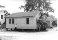
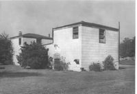
House (rear view) and shed/garage, on site affected by the construction of Interstate 26 (I-26). Address: 1344 Rutledge Avenue. Surveyor notations on back of photo: "Dkt.: 10.490. Property owner: Louise S. Carter. Tract: 154. Station: 5880+00 Rt. (house). 5880+00 Lt. (garage). Date: May 15, 1962. In R/W - Bought." [See collection description for explanation of surveyor notations.]
Two-story dwelling on site affected by the construction of Interstate 26 (I-26). Address: 1317 King Street. Adjacent lot in foreground appears to have had a building on it which had been razed. View of street corner; northwest corner of King Street and Mt. Pleasant Street. Presumably part of the Rose Garden Tourist Court; see I-26 Photo 1467. Surveyor notations on back of photo: "Dkt.: 10.490. Property owner: The Long Corporation. Tract: 200. Station: 7+10 Lt. (Mt. Pleasant Street). Date: September 11, 1962. To be cut off at R/W by SCHD [SC Highway Department]." [See collection description for explanation of surveyor notations.]
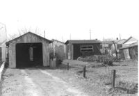
Garage and/or storage building on site affected by the construction of Interstate 26 (I-26).Address: 1317 King Street. Presumably part of the Rose Garden Tourist Court; see I-26 Photo 1467. Surveyor notations on back of photo: "Dkt.: 10.490. Property owner: The Long Corporation. Tract: 200. Station: 5889+45 Lt. Date: September 11, 1962. In R/W - Bought." [See collection description for explanation of surveyor notations.]
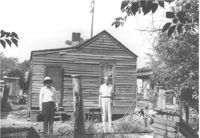
House (freedman's cottage) (rear view) on site affected by the construction of Interstate 26 (I-26). Surveyor notations on back of photo: "Dkt.: 10.490. Property owner: Martha Robinson, Est. Tract: 87-B. Station: 5825+00 Rt. Date: August 29, 1962. Proximity." [See collection description for explanation of surveyor notations.]
House (freedman's cottage) (rear view) on site affected by the construction of Interstate 26 (I-26). Surveyor notations on back of photo: "Dkt.: 10.490. Property owner: Ruth M. Bontz. Tract: 87-A. Station: 5824+80 Rt. Date: March 22, 1962. Proximity." [See collection description for explanation of surveyor notations.]
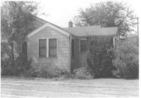
House on site affected by the widening of Route 171 (Folly Road). Surveyor notations on back of photo: "Dkt.: 10.494. Property owner: Sophie Sabel, Est. Tract: 97. Station: 372+20 Lt. Date: Mar. 21, 1962. To be cut off at R/W by SCHD [SC Highway Dept.?]. [See collection description for explanation of surveyor notations.]
House on site affected by the widening of Route 171 (Folly Road). Surveyor notations on back of photo: "Dkt.: 10.494. Property owner: G.L. Brown, et al. Tract: 69. Station: 218+90 Rt. Date: Mar. 21, 1962. Proximity. [See collection description for explanation of surveyor notations.]
House on site affected by the widening of Route 171 (Folly Road). Surveyor notations on back of photo: "Dkt.: 10.494. Property owner: H.P. Duke. Tract: 51. Station: 186+65 Rt. Date: Mar. 21, 1962. Proximity. [See collection description for explanation of surveyor notations.]
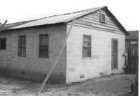
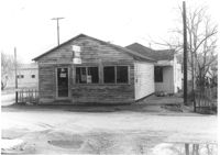
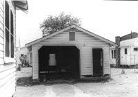
Building on site affected by the widening of Route 171 (Folly Road). Surveyor notations on back of photo: "Dkt.: 10.494. Property owner: John Harleston. Tract: 62. Station: 195+50 Rt. Date: Mar. 21, 1962. Moving item. [See collection description for explanation of surveyor notations.]
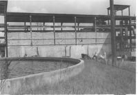
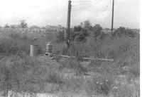
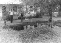
Pool and pump, on site affected by the widening of Route 171 (Folly Road). Surveyor notations on back of photo: "Dkt.: 10.494. Property owner: H.P. Duke. Tract: 51. Station: 186+65 Rt. Date: Mar. 21, 1962. Loss of pool and pump. [See collection description for explanation of surveyor notations.]
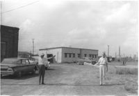
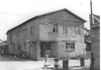
Building on site affected by the construction of Interstate 26 (I-26). View of street corner. Appears to previously have been a corner store named "Upper 10," perhaps with residence on second floor. Surveyor notations on back of photo: "Dkt.: 10.490. Property owner: Robert Martin. Tract: 38. Station: 5957+45 on CL Line 'G'. Date: September 11, 1962. In R/W - Bought." [See collection description for explanation of surveyor notations.]