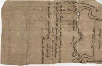
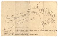
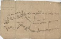
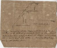
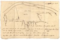
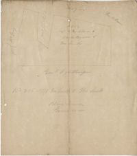
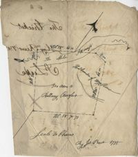
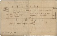
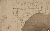
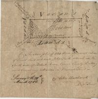
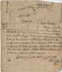
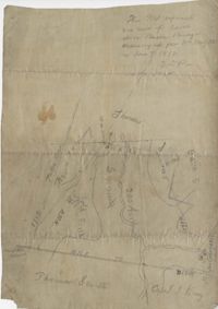
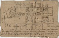
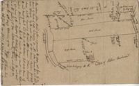
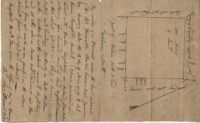
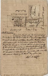
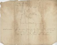
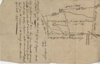
Copy of plat granted to John Atchison. "The plat annexed to the grant dated March 2, 1736." Names associated with this plat are John Atchison, James St. John, Thomas Broughton, J. Branch and Middleton. Notable geographic locations include Santee, Four Mile Creek, Santee River, and Cravens County [now in parts of Berkeley, Charleston, Georgetown, and Williamsburg counties].
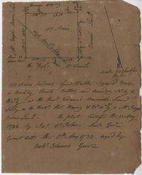
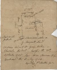
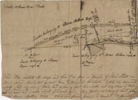
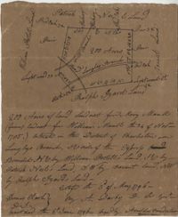
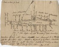
187 acres of land laid out for Walter Izard in Berkeley County butting and bounding North and West on lands of Francis Varnod, South on Thomas Waring lands and East on George Boons land. Names associated with this plat are Francis Varnod, Thomas Waring, Joseph Boone, Walter Izard, James St. John, and Robert Johnson. Notable geographic locations include St. George's Parish, Dorchester and Berkeley County.
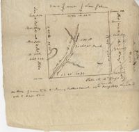
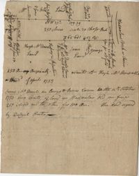
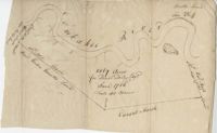
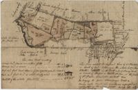
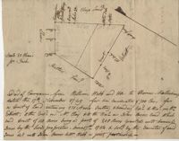
Plat of 500 acres off of the Savannah River granted to James Sutherland in 1737. Detail includes a creek of the southern branch of the Savannah River and various trees on the property lines. Names associated with this plat are James Sutherland, Patrick McKay, and James Stobo. Notable geographic locations include St. Peters Parish, Savannah Lands, and the South Branch of a creek of the Savannah River.
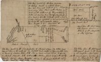
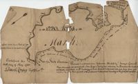
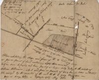
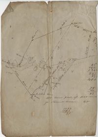
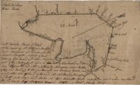
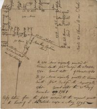
600 acres plot granted to Richard Floyd residing in Colleton County lying and budding on the southside of Bohickett Creek, shows surrounding property names and creeks, shows land notes but no land type or details. Also shown is 200 acres granted by the Lords Proprietors by William Arnell in Colleton County. Names associated with this plat are Richard Floyd, Graeme [?], the Lords Proprietors, Michael Ranell, Thomas Broughton, Robert Gibbes, William Atnel, Timothy Bellemey, Anthony Matthews, Ambross Hill, John Prescot and Neufville. Notable geographic locations include John's Island, Bohickett Creek, Colleton County, Ambrose Hill, Stono River, and Keywa [Kiawah] Island.
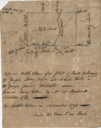
Copy of a plat of land in St. Andrew’s Parish, 103 acres are marsh land. Little other detail or explanation. At the time of the copy belonged to George Wagner. Names associated with this plat include Stephen Bull, Thomas Jones, George Wagner, Richard Godfrey, Nathaniel Brown and Thomas Jones.
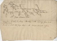
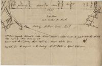
Plat of 500 acres in Colleton County. Very little detail included. Names associated with this plat are Alexander French, Thomas Clifford, Bettison, Francis Young, George Hunter, and John Bartys.
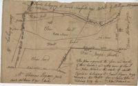
FRONT: Plat is on the northside of the Ashley River. Contains 200 acres. BACK: Plat contains 36 acres on the North side of the Ashley River. Names associated with this plat are Richard Baker, Elibee Baker, John Baker, Josiah Baker, John Guptan, James Cantley [?], James Glen, John Stevens, Joseph Child, John Ainslee, Richard Baker, William Cattell and George Hunter. Notable geographic locations include St. George's Parish, Ashley River and Berkeley County.
Plat includes 624 acres surveyed for Gideon DuPont. Plat does not contain structures. Names associated with this plat are Gideon DuPont, William Thomas Elliot, Captain Daniel Godin, and Middleton. Notable geographic locations are St. Bartholomew's Parish, the Ashepoo River and Deer Creek.
26 acres of land exchanged by John Stanyarn with Col. John Gibbes in the north side of Marshall's Creek on John's Island. Bounding on the south on lands belonging to the said Stanyarn and on all other sides on lands of John Gibbes. Laid out in 1753. Names associated with this plat are John Stanyarn, John Gibbes and Wilkins. Notable geographic locations include Johns Island and Marshall's Creek.
Plat of 163 acres in the St. George District. Very little detail or explanation provided on the plat. Names associated with this plat are David Run, John Woodrich, Elibu [?] Baker, John Drayton, and B. Wood [?]. Notable geographic locations include St. George Parish and St. George District.
Plat of 300 acres in Berkeley County. Very little detail included in the plat. Names associated with this plat are James McKelvey, John Evans and Sarah Vance. Notable geographic locations include Berkeley County and Russells Creek.
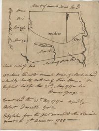
250 acre plot given to Peter Lesesne on the 20th of February 1760, butting and bounding on the south side of the Santee River. Names associated with this plat are Peter Lesesne, James Thomson, Peter Robert, Joseph Manap [?], and Phippes.
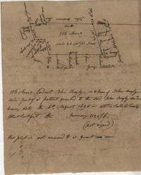
Plat of 300 acres in St. Andrew’s Parish on the Stono River originally granted to William Branford. At the time of the copy it belonged to George Wagner. Names associated with this plat are William Branford, George Wagner, Egerton Leigh, Thomas Boone and Elizabeth Hutchins.
1000 acres of land laid out for Peter Sinclair in St. James Parish, Santee. Names associated with this plat are Peter Sinclair, Susannah Lowndes, Peter Morison, Dupree, Richard Wither and Lewis Morison.
Plat of 1000 acres is surrounded by vacant land. Names associated with this plat are John Stuart. Notable geographic locations include Berkeley County and St. Stephen's Parish.
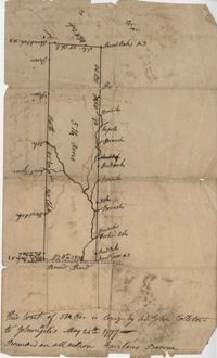
True copy of Peter Sinkler plat contains 310 acres in Craven County [now in parts of Berkeley, Charleston, Georgetown, and Williamsburg counties] bounding northwest on land of Isaac Porcher and Rene Pyre, southeast on land of Robert Taylor and Rene Ravenel, and northwest on Santee River. Names associated with this plat are Peter Sinkler, Robert Taylor, Ephraim Mitchell, Rene Pyre, Isaac Porcher, Rene Ravenel, John Brernon, and Henry Mowlon. Notable geographic locations include St. James Parish, the Santee River and Craven County.
Plan of a tract of 1000 acres of land in Wall Eye Swamp in Craven County [now in parts of Berkeley, Charleston, Georgetown, and Williamsburg counties]. Names associated with this plat are Samuel Cooper, James Sinkler, Peter Sinkler, Isham Moore, John Bremar, and William Bull.
Plat of 4883 acres belonging to Thomas Smith. Very little detail, only the outline of the property is included. Names associated with this plat are Thomas Smith, General Oglethorpe, Smith, Thomas Elliott, Hugh Bryan, and Allen. Notable geographic locations include Granville.
Plat of 500 acres granted to Robert Cahousac January 10,1771. Names associated with this plat are Robert Cahousac, Samuel Cooper, Gabriel Gigneliat [?], Mitchum, Witten, Zachariah Villeponteux, William Mazyck, Juxbury Lumber Co, William Washington, and Charles Parker. Notable geographic locations include St. Bartholomew's Parish and Charleston County.
400 acres of land once owned by James Wrixon, then Purchas Morgan, and then Henry Webster who conveyed the land to Ezekiel Branford and Christopher Peters. 250 acres came to the ownership of Ezekiel Branford (N1 and N2) and the remaining 150 acres owned by Christopher Peters (N3). The dates of purchase can be found on the plat. The lands contain pine, gum, cypress, white oak and hickory trees. The lands lie to the east of the Ponpon River. Names associated with this plat include Henry Webster, James Wrixon, Ezekiel Branford, Christopher Peters, Purchas Morgan and Alexander Watkin.
"Plan of a Plantation containing 240 acres in St. Andrew’s parish belonging to William Newbenny. Surveyed by N. Brandwill March 1772. Copy taken from the plan in the property of William Newbenny." The plat also contains the location of a structure and a road leading to it. Plantation located on East side of Ashley River. Names associated with this plat are William Mewhening, N. Brandwill, Whitenarth Tuller, William Scotts, Ralph Izard, the Lords Proprietors, William Williams and William Scott.
Plat of 250 acres on Wadmalaw Creek. Includes short explanation, but plat itself includes very little details. Names associated with this plat are Hugh McDowel, James McDowel, James Carson, Dalziel Hunter, James Young and Ellis.
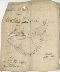
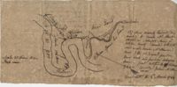
Plan of Cotton Hope Plantation on Hilton Head Island with no acreage included. Details include a marsh, swamp, and surrounding lands. Names associated with this plat are Hugh McDowel, William Horton, and Thomas Rorksdale.
Copy of a plan of 195 acres of land near the Cooper River including dams, a house, marsh and saw pit. Names associated with this plat include Mary Rupell, Robertson, Atkin, Dr. Brabangs, Withers, Jenson, Lanue and G. Arch.
Plat to identify the boundaries between John Harleston, Elias Ball's property. West branch of Cooper River. Names associated with this plat are Joseph Purcell, John Harleston, Elias Ball and John Ward. Notable geographic locations include the Cooper River and St. John's Parish.
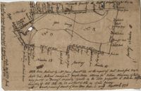
Plan of 500 acres of land south of the Mile Swamp and near the May River. Names associated with this plat are J. Pears and Bellamy Crawford. Notable geographic locations are The Thickets, May River, The Mile Swamp and St. Luke's Parish.
Plat of land belonging to Bellamy Crawford possibly called the Thickets. Names associated with this plat are Bellamy Crawford. Notable geographic locations are May River, The Mile Swamp and St. Luke's Parish.
1050 Acres surveyed for William Whayman in London, shows two separate plots (No. 12 and 13), shows the River May, shows different types of trees, creeks, and swamps that run through the property. Names associated with this plat are William Whayman, William Sandy, Joseph Hodge, William Hodgson, Robert Bradsford, Robert Dee, Robert Wright, Anson, Thomas Rivers, and Rivers. Notable geographic locations include River May.
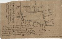
Tract of 514 acres of land conveyed by John Colleton to John Giles May 24, 1777. Bounded on all sides of Fairlawn Barony. Names associated with this plat are John Colleton, John Giles and Fairlaws. Notable geographic locations include Broad Road and Fairlawn.
"This tract was conveyed by G. Anson Esquire thro his attorney, and Richard Lambton to Thomas Rivers February 15th 1775 and from said J. Rivers to Benj. Guerad Esquire October 7th 1779." 371 Acres laid out by William James January 21th 1774 by the request of William George Roupell attorney for Georg Anson Esquire Being part of a barony originally granted to Robert Wright [illegible] Esquire by the Lords Proprietors. [illegible] now by Ansons Barony and being part of Lot N 11 of said Barony situated near May River." Plat contains identification of a path and waterways but no structural information. Names associated with this plat include G. Anson, Richard Lambton, Thomas Rivers, Benjamin Guerad, George Roupell, Robert Wright, the Lords Proprietors and Hodgson. Notable geographic locations include St. Lukes Parish, May River and Anson's Barony.
Plat of 250 acres of land granted to Bonam Sam on Wadmalaw Island the 5 May 1704. Names associated with this plat are Sam Bonam, William Lowry, Henry Livingston, and Thomas Stangarn.
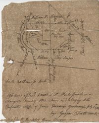
196 acres of land located in St Pauls Parish on a navigable branch of Stono River amd belonging to the confiscated estate of James D. Yarborough. Names associated with this plat include Thomas Ferguson, James Yarborough, G. Trotti, William Williamson, Charles Elliot, William Clay Snipes, Thomas Broughton, Edmond Bellinger, and Thomas Cliffon. Notable geographic locations include St. Paul's Parish, the Stono River, Road to Willows, Rutledge’s Creek, Road to Pon Pon and Jacksonborough.
120 acre plot purchased by George Rivers, shows Bohicket Creek and several smaller creeks, also denotes some marsh, highland, and riverbanks, the plot of land is divided into six smaller plots with "Broad Road" running between them. Names associated with this plat are John Rivers, Dr. Micah Jenkins, James Stanyon, George Rivers, Hearn, Matthews, Solomon Freer, William Spencer, James Rivers, John Taylor, Margaret Simpson, William Holmes, John Holmes and James Legare. Notable geographic locations are Bohicket Creek, Johns Island, and Colleton County.
Plan of a tract of land containing 130 acres situated in Darres [Parris] Island in Beaufort. Names associated with this plat are Andrew Fitzsimons. Notable geographic locations include Beaufort, Darres [Parris] Island, and Broad River.
732 acre plot of land with Boggy Branch River running through the middle of it, includes some trees and run off creeks, shows surrounding neighbors and their properties. Names associated with this plat are Arch Taylor, Stephen Ford, Lessesne and Moses Glover.
"Pursuant to a Warrant for, [?] Mitchell Esquire Surveyor General Sha [?] Ad measured and laid out unto William Peter Reahimer a tract of land containing 136 acres situated in Charleston District, bounding SW on land belonging to Thomas Broughton Esquire South on land belonging to William Singleton [?] on Mr. John Ansil and has such shape and mark as the above plat represents Surveyed 9th day of April 1785." Includes two water sources dividing the property. Names associated with this plat are William Peter Redhimer, Thomas Broughton, William Singleton, John William Ansil, and John Richardson.
Persuant to [?] from Ephraim Mitchell Esquire Surveyor General that admeasured and laid out un to William Peter Redhimer a tract of land containing 97 acres of land situated in Charleston District bounding NW [?] as represented in the plat and hath such shape and marks as the above plat Surveyed this 9th day of April 1785. Names associated with this plat are William Peter Redhimer, John Richardson, Colonel Isaac Motte, Thomas Singleton, Reating Simoner, Ephraim Mitchell and Keating Simone.
Plan of the land claimed by James Sinkler on Santee River and comprehended with the claim of White Oak Plantation belonging to Ralph Izard. Names associated with this plat are Ralph Izard, James Sinkler, Peter Sinkler, John Guerry, and Stephens.
Plat of 220 acres on the Black River belonging to John Luck. Details include the areas of the river and marsh, and the location of trees on the property lines. Names associated with this plat are John Luch and John Hardwick. Notable geographic locations include Black River and Craven County Craven County [now in parts of Berkeley, Charleston, Georgetown, and Williamsburg counties].
Plat of land along the Combahee River containing 5567 acres laid out for Daniel Doiley. Names associated with this plat are Daniel Doiley, Smith, Gordon Garrett, and Philips. Notable geographic locations include the Combahee River, Prince William's Parish and Farr Bluff.
BACK: John Griggs 1220 acres Charleston 1 June 1786 [?] Peter Freneau. FRONT: “Pursuant to a warrant from Ephraim Mitchell Esquire Surveyor General and laid out unto John Griggs a Tract of land containing one thousand two hundred and twenty acres (1220) situated in St. Bartholomew's Parish Charleston District and has such shape form and marks as the above plat represents. Likewise butting and bounding as the said plat specifies." Names associated with this plat are John Griggs, Ephraim Mitchell, Daniel Doyley, Edmund Belling, Gochran, Gabriel Stock, Gochnan [?], and Peter Freneau [?]. Notable geographic locations include the Ch[?]aw River, Charleston District and St. Bartholomew's Parish.
“Pursuant to a War- Mitchell Esquire Surveyor General [having been] admeasured and laid out unto John Griggs a tract of land containing one hundred and ninety (190) acres situated in Charleston District on the South side of Ashepoo River Bounded South-Westwardly on Lands of [?] Ladson, and part on Mr. Smiths lands on all other sides upon the said Ashepoo River and hath such form and marks as the above plat represents. Certified...this 26 day of June 1786 William Tate D. S." Names associated with this plat are John Griggs, William Tate, Ladson, Smith, Peter Freneau, and Ephraim Mitchell.
Plat contains 360 acres. Plat includes sketch of house. Names associated with this plat include John Glen, Ephraim Mitchell, Crip, Daniel Cannon, and John Richards. Notable geographic locations include St. James Parish, Goose Creek and Charleston District.
4000 acre plot of land for James Peach with its natural boundaries being rivers instead of property lines, also shows surrounding properties and their names. Names associated with this plat are James Peach, Lowright and Ellis Barce. Notable geographic locations include New River, Wrights River, Daufuskie Island, New River, Wright’s River, The North River, Cuningham Point, Savannah River, Black Oyster Bank, Turrapin Beech, Pine Island Creek, Red Bluff, and Townbridge Landing.
Plat of 1000 acres on the Scull Creek belonging to John Luck. Details include the areas of the creek and minimal buildings. Names associated with this plat are John Luck and J.B. Gerardeau. Notable geographic locations include Hilton Head Island, Cotton Hope Plantation, Fairlawn, St. Luke's Parish and Scull Creek.
83 acre parcel of land that shows the land belonging to the estate of William Williamson, shows rice fields, swamp in woods, public drains, and roads. Names associated with this plat are William Williamson, George Haigery, and James Parsons. Notable geographic locations include the Stono River and Wenners.
"Copy of a plat of a tract now belonging to Richard Goughlr." The tract contains 500 acres and states that it was granted to Isaac Lewis on March 21, 1715. Names associated with this plat are Isaac Lewis, John Broughton, John Glover, John Diamond, and Richard Goughlr [?]. Notable geographic locations include Goose Creek, St. James Parish and Black Jon Bay.
Tract of land includes 224 acres. Plat includes house and cemetery as well as a path and road. Names associated with this plat are William Harvey, William Charles, Thomas Elliott, William Harvey, Charles Linning, and Charles Elliott. Notable geographic locations include St. Andrews Parish and Wappoo Creek.
876 acres of land west of Murray Road in St. John's Parish. Names associated with this plat are Chas Johnston, Ben Castell, William Simpson, Verth, and J.G. Wiare. Notable geographic locations include Wadboo Barony.
Plat of approximately 300 acres of marsh and farm land on the Stono River. Marsh and high land are denoted on the plat with few other details. Names associated with this plat are Mansfield, Mathuvin [?] Guevin, Franics [?] Guevin, Rebecca Chapman, Francis Wilkinson, Gaspar Trotti, and Stephen Ravenel. Notable geographic locations are the Stono River.
Plat of land of 64 acres laid out for Allard Belin situated on Sandy Island. Names associated with this plat are Allard Berlin, John Hardwick and D.T. Waring.
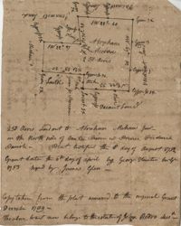
Copy of a plat of 250 acres laid out to Abraham Michau on the north side of Santee River and “now belonging to John Pedro." Names associated with this plat are Abraham Michau, John Pedro, George Hunter and James Glen. Notable geographic locations include the Santee River, Prince Frederick Parish and Georgetown District.
77 acres of marsh in two pieces situated on Johns Island along Stono River. Names associated with this plat are J.N. Mainville, Thomas Simmons, James Nicholas, Guervin, William Simmons and Marshall. Notable geographic locations are the Stono River, Johns Island, Charleston District, and Marshalls Creek.
Plat of 210 acres belonging to William Williams surrounded by land owned by Thomas Pinckney, Christopher Smith, and Thomas Dalton. No other notes written as to the location of the land. Very little detail on the plat included. Names associated with this plat include William Williams, Thomas Pinckney, Christopher Smith, Thomas Daulton, Thomas Smith, Edward Weekly, William Dry, Ralph Izard, Charles Fields, John Jolhimns [?], Thomas Broughton, and Hannah English aka Hannah Williams.
Copy of a plat granted to Abraham Michau north side of Santee and containing 213 acres in the Georgetown district in Craven County [now in parts of Berkeley, Charleston, Georgetown, and Williamsburg counties]. Names associated with this plat are Abraham Michau, James St. John, Thomas Broughton, Paul Michau, and John Dear.
876 acre plot for Simpson, shows roads, houses, and rivers/creeks, no names on any of the details, includes surrounding tracts of lands and trees on the property boundaries. Names associated with this plat are Simpson, Keith, James Gray Wiase, and Charles Johnston.
82 Acre plat of land, shows some trees with minimal notation. Names associated with this plat are John Green and Anthony Mitchell. Notable geographic locations include Waccamaw Neck.
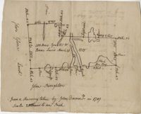
Plat of 130 acres on the Pee Dee River. Explains the plat and the surrounding area, drawing itself has little detail. Names associated with this plat are William Swinton, Joseph LaBruce, John White, James St. John, Elias Hopkin, and Thomas [?]. Notable geographic locations include the Pee Dee River, Black River, Weehaw Plantation, Kensington Plantation, Weehaw Creek, Georgetown, and Craven County [now in parts of Berkeley, Charleston, Georgetown, and Williamsburg counties].
Plat of 383 acres on Mary Creek Swamp belonging to Joseph Coachman. Details include the property lines, the location of the swamp, and location of a few trees. Names associated with this plat are Joseph Coachman, J. Hardwick, John LaBruce, Cattle, and Ralph Izard.
400 acre plot of David Elliot that includes what appears to be a marsh called Great Bay, no land types or detail. Names associated with this plat are David Elliot, Washington, Henry Sattus and J. Hardwick. Notable geographic locations include Georgetown and Great Bay.
Plat of 200 acres above Bacon Bridge surveyed for William Drayton. Details include the property lines, trees, the location of the swamp, a field, a canal and roads. Names associated with this plat are Joseph Coachman, William Drayton, Thomas, Thomas Smith, J.J. Keersy [?], Chandless, Gales, and J.H. Waring. Notable geographic locations include Mary Creek Swamp [?], Broad Road, and Bacon Bridge.
Copy of a plat laid out at Goose Creek now belonging to Benjamin Mazyck. 200 acres of land commonly called Busharia. Butting and bounding on the north and west on Col. James Moore land and the south on Captain Schrenckingh and on the east on Madam Davis' land. Names associated with this plat are Benjamin Mazyck, Davis, Lawson, Thomas Smith, Benjamin Schrenckingh, James Moore, and David Daw. Notable geographic locations include Busharia, Booshee, and Goose Creek.
Plan of lands at Bee Creek belonging to Mr. James Bolen called Gray's Hill. Names associated with this plat include James Bolen. Notable geographic locations include St. Lukes Parish, Gray's Hill, Grey's Hill Landing, Bees Creek, and Purrysburgh.
Copy of a plat annexed to the original grant for 1153 acres of land to Thomas Farr lettered A-E. Names associated with this plat are Daniel Green, Thomas Farr, Elizabeth Gibbs, Christopher Wilkinson, Joseph Smith, Andrew Smith, Thomas Smith, George Haig, Joseph Farr, Humphrey Sommers, and Benjamin Stoney.
Plat of 320 acres in the Georgetown District on the Black Mingo waters with marshes surrounding it. Little detail included. Names associated with this plat include Thomas Bull, Job Rothmaler, McCottry, Robert Davidson, Hugh Swinton and Sam Day.
Plan of the old field tract in St. John's Parish late belonging to Francis Huger now to John Ball. Compiled and copied from original papers. Names associated with this plat are James Child, Francis Huger, John Ball, James Child, William Walter [?], Nathaniel Johnson, John Archdale, Thomas Droughton, P. Pawley, J. Child and Hentey [?].
Plat of three tracts of land in a deed of conveyance from Peter Michau to Theodore Gaillard, the plats being 200, 300, and 500 acres respectively. Each plat contains a short explanation as to its conveyance and contains little geographic detail. Names associated with this plat Peter Michau, Theodore Gaillard, Isaac Chardon, Andrew DeLavillette, Thomas Broughton, Paul Mazyck, Nicholas Lenude, Isaac Michau, Andrew Thimbert, James St. John and Thomas Johnson.
Plat includes 272 Acres with the Broad Road bisecting the property. Names associated with this plat are William Perry Perry, N. Bradwell, Archer Smith, the Ministry Lands and Joseph Perry. Notable geographic locations include St. George’s Parish, Bach Hill, Dorchester, and Broad Road.
Copy of plat of 300 acres of land situated in Craven County on the north side of the Santee River bounding north east on Bennett's land and the other sides on vacant land. Names associated with this plat are Susannah Williams, Thomas Ferguson, Moses Bennett, and Benjamin [?]. Notable geographic locations include the Santee River, Craven County [now in parts of Berkeley, Charleston, Georgetown, and Williamsburg counties], and Georgetown.
A collection of five maps and three charts describing land owned by Jonah Horry in South Carolina. The first four maps were drawn from surveys made by John Goddard in 1793; the last map was drawn from a survey made by John Horry Dent in 1836.
Copy of a tract of 127 acres in the marsh on the Ashepoo River belonging to Sarah McPherson. Little detail included in the plat. Names associated with this plat are Sarah McPherson, Willliam Spense, and Joshua McPherson. Notable geographic locations are the Ashepoo River, Deer Creek, Ladson, and Colleton County.
Copy of plan of a plantation on Stono Swamp commonly called Stono Plantation belonging to Thomas Ferguson. Contains 630 acres. Approximately 360 acres is swamp and approximately 270 acres is highland. Names associated with this plat are Thomas Ferguson, George Haig, Joseph Farr, Mary Williams, Smith and John McSweeney. Notable geographic locations include Stono Swamp, Stono Plantation and Charleston.
John Grigg 69 Acres Certified for him Feb 28th 1793. John Grigge 69 acres recorded 24 September 1793. Names associated with this plat are John Grigg, William Jones, William Burens, Crompton, H. J. [?] Kennedy, Barnes, Bowels, Somes [?] and John Buren. Notable geographic locations include Fairfield County, Camdon [Camden?] District, and Sawines [?] Creek.
Plan of a tract of land on the NE side of Edisto River called Riverside Plantation and contains 1100 acres belonging to estate of Thomas Ferguson lately sold to Martin. Names associated with this plat included Benjamin Berry, Bull, Martin, John Eberley, Edward Perry, and Thomas Ferguson. Notable geographic locations include St. Paul's Parish, the Edisto River, Parkers Ferry, Public Road to Charleston, Riverside Plantation, and Charleston District.
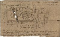
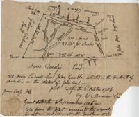
Plat contains 310 acres layer out for John Gamble granted November 6, 1706. Plat contains location of house. Names associated with this plat are John Gamble, Gideon Fishero, Amos Donoly, John Deas, Francis Cobia, Purull, and F. Bremar.
“Plan of parcel of land of late belonging to John Jones and now sold and conveyed by the said Jones to James Carsen for 850 acres but the request of the said Carsen. The said tract of land has been resurveyed and find it to contain but 805 acres of land or there about, so that the original survey must have taken in 45 acres of the marshes of Bohicket River...true copy taken from the original plat in the property of Mr. William Carsen in June 1794." Names associated with this plat are John Carsen, John Jones, James Carsen, William Chambers, James Young, Thomas Winborns, McDoul, Abigail Winborn, John Gibbs, Wilkins, and William Carsen. Notable geographic locations include St. John's Parish, Bohicket River, Wadmalaw River and Johns Island.
Plat contains 211 acres copied from a release form annexed to Nathaniel Broughton to Alexander Broughton. Part of Mulberry Tract. Names associated with this plat are William John Broughton, Nathaniel Broughton, Alexander Broughton and A. Domini. Notable geographic locations include Doken Creek, The Farm, St. John's Parish and Long Branch Creek.
Copy of a plan of a plantation or tract of land lately sold to Isaac Holmes by James Legare lying on Johns Island, Charleston District from a plan annexed to Arleas from Thomas Legare and annexed to Isaac Holmes 1784. 380 acres. Names associated with this plat are Thomas Legare, James Legare, and Isaac Holmes. Notable geographic locations include Charleston District and Johns Island.
Plan of a parcel of land situated on Johns Island and containing 86 1/2 acres. Being part of a body of land belonging to Thomas Mathews. Bounded northwardly by a public road, eastwardly on James Legare's land, and southwardly on land belonging to Isaac Holmes and Thomas Legare. Intended to be conveyed to Isaac Holmes. Names associated with this plat are Thomas Mathews, Isaac Holmes, Thomas Legare, William Stanyarn, Matthews and James Legare.
True copy of a plan surveyed for an inland plantation for Breton Singletary containing 500 acres situated in Craven County butting and bounding northerly on late William North, southerly by Singletary and all other sides on lands not yet laid out. Names associated with this plat are Thomas Broughton, Breton Singletary, Richard Beresford, William North, Charles Craven, Alexander Heward, John St. Martin, Thomas Valley, Mary Henry, and Robert Smith. Notable geographic locations include Wambaw, St. Thomas Parish, and Craven County [now in parts of Berkeley, Charleston, Georgetown, and Williamsburg counties].
Copy of a plat of 490 acres owned by Francis Smith annexed to the lands owned by Laughlin McIntosh. Names associated with this plat are Francis Smith, Laughlin McIntosh, Beadon Colonel, Captain Hutchinson, and Thomas Fleming. Notable geographic locations include St. Bartholomew's Parish, Chickaw and Charleston District.
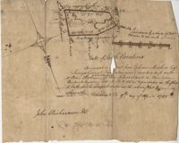
Copy of two adjoining plats of lands on Johns Island originally granted to Ambrose Hill now belonging to Miller St. John. Copied from the plats annexed to the original grants in 1795. Names associated with these plats are Ambrose Hill, Miller St. John, Richard Floyd, the Lords Proprietors, Job Howe, N. Johnson, Thomas Broughton and Lambert Lanee. Notable geographic locations include Johns Island, Ambrose Hill, Bohicket Creek, and Colleton County.
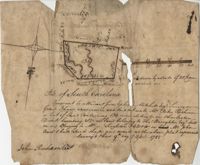
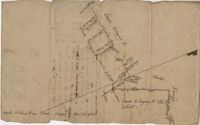
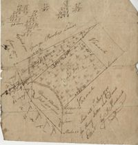
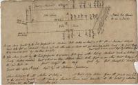
Plat of two tracts of land on Johns Island, both are 300 acres. Notes give a brief description of the properties, the drawings include very little detail. Names associated with this plat include John Prescot, Anthony Mathews, Graemede, the Lords Proprietors, Robert Cole, Robert Gibbs, Heufville, Arnold, Richard Floyd and Thomas Broughton. Notable geographic locations include Colleton County, Kywah [Kiawah] Creek, and Johns Island.
500 acre plat given to William Campbell in the Georgetown District on Kingston Lake Swamp, shows highlands, swamp, indigo area, and an area named food provision, shows details and surrounding property owners.
Plat of land which includes a marsh and creeks, very little other detail. Names associated with this plat are Purcell, Thomas Rose, John Blade, and E. Rivers. Notable geographic locations include Tiger Swamp.
Plat of 237 acres belonging to Rob Reeves Gibbes. Detailed marsh and high land along with the location and outline of a house. Names associated with this plat are Robert Reeve Gibbes, Nathaniel Heyward, John Gibbes, Thomas Gibbes, and Lewis Gibbes. Notable geographic locations include the Combahee River, Tupelo Swamp, and Charleston District.
Plat contains 420 acres But is to the estate of Fulmer and Shubrick and to Shubreek and Hewart also bounding to Hapensack and Izard. Plat includes the location of the house and paths connecting the property to its neighbors. Names associated with this plat include William Conrade Heekeley, Shubrick, Fulmer, Hewart, Hapensack, Ralph Izard, and Thomas Abernethie. Notable geographic locations include St. James Parish, Goose Creek, Wolf Castell, Berkeley County, and Charleston District.
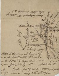
Sketch of the survey ad laying out of a small tract called Red Branch on the west side of the Cooper River containing 6 acres lately sold by Middleton to Leval part of 400 acres tract granted to Dr. Snow. Names associated with this plat are Peter Pamplat, Peter Gray, Snow, and Middleton.
Plat includes Langley Branch Road going through plat as well as a road. Plat consists of 200 acres. Names associated with this plat are Mary Manlt, William Manlt, William Postell, Patrick Neel, Ralph Izard, Thomas Clark, A. Darby, Amoldus Vanderhorst, Margaret Manlt and W.S. Smith. Notable geographic locations include St. George’s Parish, Langley Branch, Cypress Road, Dorchester, Cypress Swamp, and Charleston District.
"A Plan of a Plantation or Tract of Land on Penny Creek a Branch of Ponpon or Edisto River late the property of Joseph Bee Esquire now belonging to John Champney Esquire." Plat contains 687 acres on the north side of Penny Creek the plat is divided by use of lands and the location of structures on the property. Names associated with this plat are John Champney, Dr. John Mitchell, Thomas Bee, Joseph Bee, and George Savage. Notable geographic locations include Penny Creek, Edisto River, Pon Pon River, Landing Road, and Bridge Road.
200 Acre plot of land laid out to John Freer, shows some creeks and trees, no land type or details. Names associated with this plat are John Freer, Stephen Bull, Joseph Blake, William Weston, William Green, and B. Sam. Notable geographic locations include Colleton County, Freer District, and Wadmalaw River.
169 acre plot given to Kent McCall, shows roads and surrounding neighbors, shows the Ashley River and some trees on the property borders. Names associated with this plat are Kent McCall, Thomas Parker, Roger Smith, Burnard Elliott, Crughtton, William Elliott, John Heard, Benjamin Dart, Elizabeth McCall, John Ward, John Parker, and Thomas Parker. Notable geographic locations include St. Andrew's Parish and the Ashley River.
128 acres situated in the Charleston district unto James Maxwell situated in the parish of St. Paul, Charleston District April 1, 1797. Names associated with this plat include James Maxwell, Jane Ladson, Smith, John Boyles, John Somers and Brigdon Smith. Notable geographic locations include St. Paul's Parish, Jerico Plantation, Bretton Hall Plantation, Bay Swamp, and Charleston District.
Copy of tract of land containing 200 acres, butting and bounding south and west by William Elliott, and on the east by Clay, and to the north by John Rivers. Names associated with this plat include William Webb, Thomas Mellichamp, Butler, William Elliott, William Clay, Shem, John Rivers, John S. Cripps, Samuel Jones, the Lords Proprietors, and Daniel Gibson.
Copy of Plat of 157 acres of land laid out to Harrison on Wadmalaw Island at the head of Wadmalaw River. Names associated with this plat are Christopher Harrison, Henry Walkins, and Luna Williams.