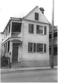
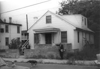
House on site affected by the construction of the Crosstown. Address: 2 Norman Street. Surveyor notations on back of photo: "Dkt.: 10.524. Property owner: Sadie Belle Weathers. Tract: 24. Station: 66+35 CL Lt. Date: Oct. 13, 1964. In R/W - Bought." [See collection description for explanation of surveyor notations.]
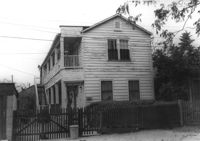
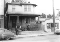
House on site affected by the construction of the Crosstown. Address: 184 Spring Street. Surveyor notations on back of photo: "Dkt.: 10.524. Property owner: Laura H. Middleton. Tract: 26. Station: 65+40 Rt. Date: Oct. 13, 1964. In R/W - Bought." [See collection description for explanation of surveyor notations.]
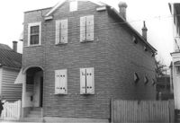
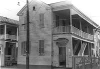
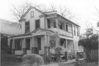
House on site affected by the construction of the Crosstown. Address: 112 Bogard Street. Surveyor notations on back of photo: "Dkt.: 10.524. Property owner: Susan D. Butler, Est. Tract: 65. Station: 76+00 CL Rt. Date: Oct. 14, 1964. In R/W - Bought." [See collection description for explanation of surveyor notations.]
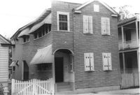
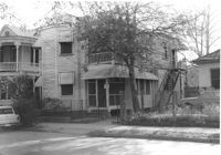
House on site affected by the construction of the Crosstown. Address: 116 Bogard Street. Surveyor notations on back of photo: "Dkt.: 10.524. Property owner: Arletha Powers. Tract: 63. Station: 75+40 CL. Date: Oct. 14, 1964. In R/W - Bought." [See collection description for explanation of surveyor notations.]
House on site affected by the construction of the Crosstown. Address: 116 Bogard Street. Surveyor notations on back of photo: "Dkt.: 10.524. Property owner: Arletha Powers. Tract: 63. Station: 75+40 CL. Date: Oct. 14, 1964. In R/W - Bought." [See collection description for explanation of surveyor notations.]
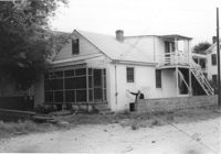
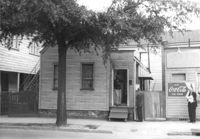
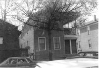
House (rear corner view) on site affected by the construction of the Crosstown. Address: 110 Bogard Street. Surveyor notations on back of photo: "Dkt.: 10.524. Property owner: Thomassina Elizabeth McCray. Tract: 72. Station: 76+60 Rt. Date: Oct. 14, 1964. In R/W - Bought." [See collection description for explanation of surveyor notations.]
House on site affected by the construction of the Crosstown. Address: 71 Kracke Street. Surveyor notations on back of photo: "Dkt.: 10.524. Property owner: William Henry Godfrey. Tract: 66. Station: 76+10 Lt. Date: Oct. 14, 1964. Portion in R/W to be removed." [See collection description for explanation of surveyor notations.]
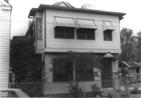
House (rear view) and lot on site affected by the construction of the Crosstown. Address: 18-20 Wescott Street. Surveyor notations on back of photo: "Dkt.: 10.524. Property owner: Ralph E. Thornley, et al. Tract: 11. Station: 62+10 Lt. Date: Oct. 13, 1964." [See collection description for explanation of surveyor notations.]
Side view of house on site affected by the construction of the Crosstown. Address: 119 Bogard Street. Surveyor notations on back of photo: "Dkt.: 10.524. Property owner: Rebecca S. Cooper. Tract: 55. Station: 73+90 Rt. Date: Oct. 14, 1964. In R/W - Bought." [See collection description for explanation of surveyor notations.]
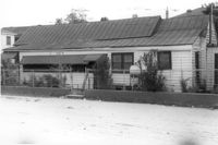
House on site affected by the construction of the Crosstown. Address: 110 Bogard Street. Surveyor notations on back of photo: "Dkt.: 10.524. Property owner: Thomassina Elizabeth McCray. Tract: 72. Station: 76+60 Rt. Date: Oct. 14, 1964. In R/W - Bought." [See collection description for explanation of surveyor notations.]
House on site affected by the construction of the Crosstown. Address: 190 Spring Street. Surveyor notations on back of photo: "Dkt.: 10.524. Property owner: E.H. Heidman, Est. Tract: 18. Station: 24± Lt. (Spring Street). Date: Oct. 13, 1964. Portion in R/W to be removed." [See collection description for explanation of surveyor notations.]
House on site affected by the construction of the Crosstown. Address: 163A Line Street [163 Line Street]. Surveyor notations on back of photo: "Dkt.: 10.524. Property owner: Ethelyn M. Parker. Tract: 95. Station: 82+50 Rt. Date: Dec. 1, 1964. In R/W - Bought." [See collection description for explanation of surveyor notations.]
House on site affected by the construction of the Crosstown. Address: 269 Ashley Avenue. Surveyor notations on back of photo: "Dkt.: 10.524. Property owner: Paul Graham. Tract: 82. Station: 79+20 Lt. Date: Oct. 14, 1964. In R/W - Bought." [See collection description for explanation of surveyor notations.]
House on site affected by the construction of the Crosstown. Address: 117 Sheppard Street. Surveyor notations on back of photo: "Dkt.: 10.524. Property owner: Julia Sharpe, et al., Est. Tract: 140. Station: 17+85 Rt. N.B. lane. Date: Dec. 2, 1964. Condemned." [See collection description for explanation of surveyor notations.]
House on Sheppard Street on site affected by the widening of U.S. Route 17. Address 131 Sheppard Street. Surveyor notations on back of photo: "Dkt.: 10.524. Property owner: William Delestine, et al. Tract: 127. Station: 90+20 CL. Date: Dec. 2, 1964. In R/W - Bought." [See collection description for explanation of surveyor notations.]
House on site affected by the construction of the Crosstown. Address: 127 Sheppard Street. Surveyor notations on back of photo: "Dkt.: 10.524. Property owner: Essie W. Jenkins. Tract: 129. Station: 91+50 Rt. Date: Dec. 2, 1964. In R/W - Bought." [See collection description for explanation of surveyor notations.]
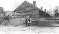
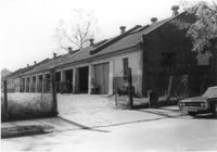
City Garage, on site affected by the construction of the Crosstown. Address: 134 Line Street. Surveyor notations on back of photo: "Dkt.: 10.524. Property owner: City of Charleston. Tract: 128. Station: 90+50 CL Rt. Date: Dec. 2, 1964. Partially in R/W." [See collection description for explanation of surveyor notations.]
City Garage, on site affected by the construction of the Crosstown. Address: 134 Line Street. Surveyor notations on back of photo: "Dkt.: 10.524. Property owner: City of Charleston. Tract: 128. Station: 90+50 CL Rt. Date: Dec. 2, 1964. Partially in R/W." [See collection description for explanation of surveyor notations.]
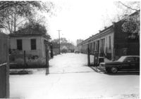
Looking down driveway between City Garage and building with gas pump, on site affected by the construction of the Crosstown. Address: 134 Line Street. Surveyor notations on back of photo: "Dkt.: 10.524. Property owner: City of Charleston. Tract: 128. Station: 91+00 CL Rt. Date: Dec. 2, 1964. Panoramic view." [See collection description for explanation of surveyor notations.]
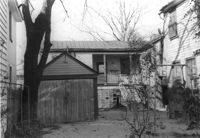
Storage shed or garage and backyard in rear of house on site affected by the construction of the Crosstown. Address: 160½ Line Street [160 Line Street]. Surveyor notations on back of photo: "Dkt.: 10.524. Property owner: John Meyer, Est. Tract: 101. Station: 83+65 Lt. Date: Dec. 1, 1964. In R/W - Bought." [See collection description for explanation of surveyor notations.]