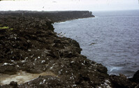
Letter from William H. W. Barnwell to Hetty Barnwell describing the "ladies" of Litchfield, Conn. and inquiring about news in Beaufort, SC. June 21, 1826.
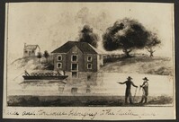
Sarah Ann Marshall writes her aunt with the family news from Cheraw. She reports that many people in the area have been sick, including family members, though most have recovered.
House (rear view) on site affected by the construction of Interstate 26 (I-26). Possibly on Rivers Avenue. Surveyor notations on back of photo: "Dkt.: 10.486. Property owner: James M. Miller. Tract: 8. Station: 10+45 CL (Line D). Date: May 30, 1961. In R/W - Bought." [See collection description for explanation of surveyor notations.]
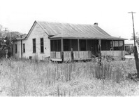
House on site affected by the construction of Interstate 26 (I-26). Possibly on Rivers Avenue. Surveyor notations on back of photo: "Dkt.: 10.486. Property owner: James M. Miller. Tract: 8. Station: 10+45 CL (Line D). Date: May 30, 1961. In R/W - Bought." [See collection description for explanation of surveyor notations.]
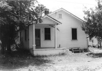
House on site affected by the construction of Interstate 26 (I-26). Possibly on Rivers Avenue. Surveyor notations on back of photo: "Dkt.: 10.486. Property owner: Mrs. Hazel Faulkner. Tract: 9. Station: 10+35 Lt. Date: May 30, 1961. In R/W - Bought." [See collection description for explanation of surveyor notations.]
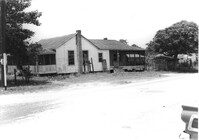
House on site affected by the construction of Interstate 26 (I-26). Piggly Wiggly store across the street, in background. Possibly on Rivers Avenue. Surveyor notations on back of photo: "Dkt.: 10.486. Property owner: Mrs. Hazel Faulkner. Tract: 9. Station: 10+35 Lt. Date: May 30, 1961. In R/W - Bought." [See collection description for explanation of surveyor notations.]
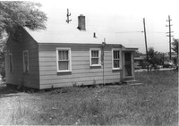
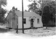
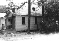
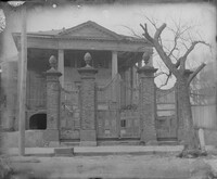
House on site affected by the construction of Interstate 26 (I-26). Building address number 1806. Possibly on Rivers Avenue. Surveyor notations on back of photo: "Dkt.: 10.486. Property owner: Cleve G. Murray. Tract: 12. Station: 10+90 Lt. Date: May 30, 1961. In R/W - Bought." [See collection description for explanation of surveyor notations.]
House (corner view, rear) on site affected by the construction of Interstate 26 (I-26). Building address number 1806. Possibly on Rivers Avenue. Surveyor notations on back of photo: "Dkt.: 10.486. Property owner: Cleve G. Murray. Tract: 12. Station: 10+90 Lt. Date: May 30, 1961. In R/W - Bought." [See collection description for explanation of surveyor notations.]
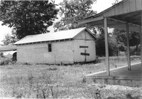
Structure (garage or shed) on site affected by the construction of Interstate 26 (I-26). Possibly on Rivers Avenue. Surveyor notations on back of photo: "Dkt.: 10.486. Property owner: Cleve G. Murray. Tract: 12. Station: 11+20 Lt. Date: May 30, 1961. In R/W - Bought." [See collection description for explanation of surveyor notations.]
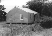
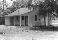
House on site affected by the construction of Interstate 26 (I-26). Possibly on Rivers Avenue. Surveyor notations on back of photo: "Dkt.: 10.486. Property owner: Phillip H. Livingston. Tract: 13. Station: 11+40 Lt. Date: May 30, 1961. In R/W - Bought." [See collection description for explanation of surveyor notations.]
House (corner view) on site affected by the construction of Interstate 26 (I-26). Possibly on Rivers Avenue. Surveyor notations on back of photo: "Dkt.: 10.486. Property owner: Phillip H. Livingston. Tract: 13. Station: 11+40 Lt. Date: May 30, 1961. In R/W - Bought." [See collection description for explanation of surveyor notations.]
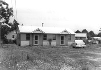
House (duplex) on site affected by the construction of Interstate 26 (I-26). Building address numbers 1809A and 1809B. Possibly on Rivers Avenue. Surveyor notations on back of photo: "Dkt.: 10.486. Property owner: Joseph S. & Vivian G. Walsh. Tract: 14. Station: 12+00 (Line D). Date: May 30, 1961. In R/W - Bought." [See collection description for explanation of surveyor notations.]
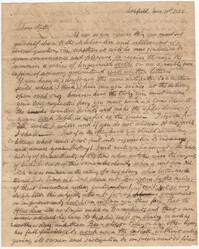
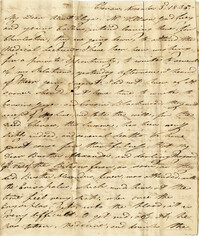
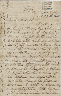
Letter from Madame Baptiste (Ellen Lynch), from the Brown County, Ohio, Ursuline Convent to brother, Bishop Patrick Lynch, in Baltimore. Madame Baptiste describes how she disguised herself "as a secular" in her travel north and discusses the opening of an academy in Columbia. April 27, 1858. 4p.
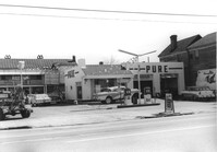
Pure Gas Station: and neighboring house, on site affected by the construction of the Crosstown. Address: 522 Meeting Street. Surveyor notations on back of photo: "Dkt.: 10.518. Property owner: Pure Oil Co. Tract: 1. Station: 38+40 on CL S.B. lane Route 17. Date: Mar. 6, 1963. In R/W - Bought. [See collection description for explanation of surveyor notations.]