Roadside (Dorchester Road) on site affected by the construction of Interstate 26 (I-26). Appears to be residential area, with a hedge along the sidewalk, likely in front of a house. Surveyor notations on back of photo: "Dkt.: 10.480. Property owner: Christine R. Kincaid. Tract: 174. Station: 128+55 - 129+04 Rt. (Route 642) [Dorchester Road]. Date: May 30, 1961. Damage to landscaping." [See collection description for explanation of surveyor notations.]
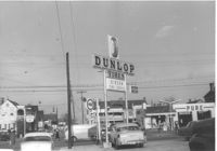
Busy intersection on site affected by the construction of Interstate 26 (I-26). Address: intersection of Lee Street and Meeting Street. Pure gas station, Gibson Tire Service / Dunlop Tires, and Sinclair gas station in view. Surveyor notations on back of photo: "Dkt.: 10.517. Property owner: Thomas P. Gibson. Tract: 59. Station: 37±00 Lt. - Route 17. Date: February 21, 1963. All in R/W." [See collection description for explanation of surveyor notations.]
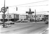
Busy intersection on site affected by the construction of Interstate 26 (I-26). Address: intersection of Lee Street and meeting Street. Features Gibson Tire Service / Dunlop Tires; sign for Pure gas station in left foreground. Surveyor notations on back of photo: "Dkt.: 10.517. Property owner: Thomas P. Gibson. Tract: 59. Station: 37±00 Lt. - Route 17 survey. Date: March 5, 1963. All in R/W." [See collection description for explanation of surveyor notations.]
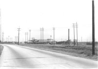
Road (presumably King Street Extn.) to Virginia-Carolina Chemical Corp. with its buildings in background, on site affected by the construction of Interstate 26 (I-26). Surveyor notations on back of photo: "Dkt.: 10.490. Property owner: V.C. Chemical Co. Tract: 1. Station: Panoramic view from North (see plans). Date: September 11, 1962. (For information.)" [See collection description for explanation of surveyor notations.]
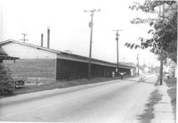
Road alongside length of building, on site affected by the construction of Interstate 26 (I-26).Address: Heriot Street. Presumably part of lumber yard. Surveyor notations on back of photo: "Dkt.: 10.490. Property owner: G.S. Carter & Son., Inc. Tract: 143. Station: 5878+40 Lt. Date: August 29, 1962. To be cut off at R/W." [See collection description for explanation of surveyor notations.]