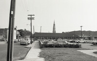
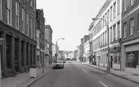
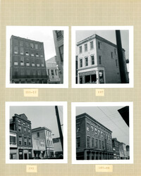
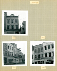
Black-and-white photograph of the view south on Meeting Street from 242 Meeting, showing Anderson Electric Co. (246 Meeting) at right and the Best Western King Charles Hotel (237 Meeting) at left.
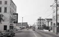
Black-and-white photograph of the view south on King Street from Wentworth Street, showing 270 King (Shahid's Furniture City) (left) and 273 King Street (right) down to approximately 240 King. Diana Shops (264 King) and Kerrison's building (260 King) also in view.
Black-and-white photograph of the view south on King Street from 260 King Street (Kerrison's building) down to approximately 240 King. Snelgrove’s dress shop (258 King) and Daisy Bogin dress shop (256 King), and the corner of Hasell Street are also in view.
Black-and-white photograph of the view north on King Street showing the east side of King Street from 190 King Street (right) and 191 King Street (left). Kerrison's building in the background.
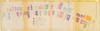
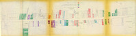
One of four maps of King Street building footprints, hand-colored to designate status. This map illustrates the historical significance of buildings on King Street from Calhoun Street to Queen Street.
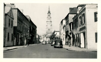
Looking north on Church Street from Chalmers Street. Features buildings on the west side of the street: 127 Church, 129 Church, 131 Church, and the Dock Street Theater). Also in view are buildings on the east side of the street: 18 Chalmers Street, 132 Church Street, and St. Philip's Church). Cars are parked on the street.
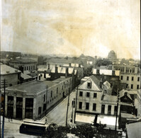
View of Charleston from rooftop at northeast corner of Wentworth and Meeting Streets, facing west, with streetcar passing. Buildings in view include Kahal Kadosh Beth Elohim Synagogue and Hirsch Israel Building. Page 22, Photo 1 of collection. 3.5" x 3.5" B/W photograph.
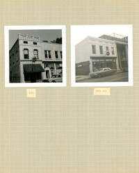
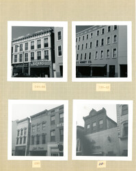
Two B&W photographs of buildings on the west side of King Street: Left (159-161): 159 King Street (Hildebrands) and 161 King Street; Right (201-203): 201 King Street (Castanes Grocery) and 203 King Street (later demolished for the construction of Victoria Center).
Three B&W photographs of buildings on the west side of King Street: Top left (337-339): 337 King Street (King's Restaurant) and 339 King Street (Fox Hi-Fi); Top right (331-335): 331 King Street, 333 King Street, and 335 King Street (Lesser-Tanenbaum); Bottom left (327-329): 327 King Street (Barton's Candy Card & Gift Shop) and 329 (Gloria Theater).
Black-and-white photograph of the view north on King Street showing the east side of King Street from 190 King Street (Home Appliance & Service Co.). Kerrison's building in background.
Four B&W photographs of buildings on the west side of King Street: Top left: 381 King Street (Felder's Rexall Drugs); Top right (367-369): 367 (Convertino's One Hour Cleaning) and 369 King Street (Lesser's Credit Jewelers); Bottom left (369-371): 369 King Street (Lesser's Credit Jewelers) and upper left portion of 371 King Street; Bottom right (341-343): 341 King Street (C.W. Kessler's) and 343 King Street (Askew's Clothiers).
Four B&W photographs of buildings on the east side of King Street: Top left (340-342): 340 King Street (Charlie Gilik Tailor Shop) and 342 King Street (Dior's Wigs); Top right (334-338): 334 King Street (Elza's), 336 King Street, and 338 King Street; Bottom left (330-334): 330-332 King Street (Clement Furniture Co.) and 334 King Street (Elza's); Bottom right: 330-332 King Street (Clement Furniture Company).
Four B&W photographs of buildings on the east side of King Street: Top left (368-370): 368 King Street (Club 400) (demolished for parking lot) and 270 King Street (World Finance Corp.); Top right: 362-364 King Street (Kaybee); Bottom left (354-356): 354 King Street and 356 King Street (White House Grocery); Bottom right (344-348): 344 King Street (Clark Clothier), 346 King Street, and 348 King Street (American Arcade - American Mortgage Co.)
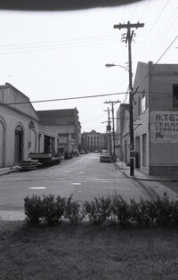
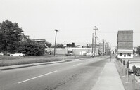
Black-and-white photograph of the view east on Market Street from near the intersection of Archdale Street. Market Hall in the distance. Goodyear building at left; 40 Archdale Street at right.
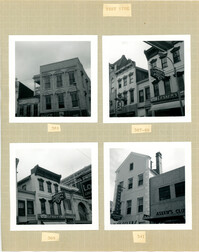
Four B&W photographs of buildings on the east side of King Street: Top left (178-184): 178 King Street (W.K. Prause Co.), 180 King Street, 182 King Street, and 184 King Street; Top right: 174 King Street; Bottom left: 164 King Street (Charleston Library Society) [labeled 168 on album page]; Bottom right (160-162): 160 King Street and 162 King Street.
Four B&W photographs of buildings on the west side of King Street: Top left (181-183): 181 King Street (Jack Patla Antiques) and 183 King Street (The Art Shop); Top right (175-179): 175 King Street, 177 King Street, and 179 King Street (Fralix & Sons); Bottom left (169-173): 169 King Street (R.M. McGillivray's) and 171-173 King Street; Bottom right (165-169); 165 King Street and 169 King Street (R.M. McGillivray's).
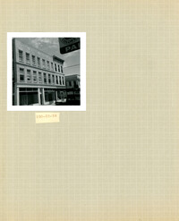
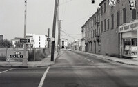
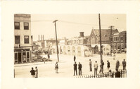
View looking east on Market Street from the junction of King Street and Market, showing the parking lot where Belk Department Store once was (left) and 220 King Street (Blue Knight Gallery) (right) down to Market Hall (distance). Meeting Street elevation of the Arnold-Hornik Building (112 North Market) also in distance. "Sold" sign on fence surrounding the lot, which is now the site of Charleston Place / Charleston Center.
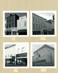
Four B&W photographs of buildings on the east side of King Street: Top left (188-200): 188 King Street (Installment Finance Co. Loans), 190 King Street, and 192-200 King Street (Hoffman House); Top right (188-190): Edge of 188 King Street (Installment Finance Co. Loans) and 190 King Street (Home Appliances and Service Co.); Bottom left: 188 King Street (Installment Finance Co.); Bottom right (184-186): 184 King Street (Dinty Moore's) and 186 King Street.
Black-and-white photograph of Market Hall (188 Meeting Street) and the view east on South Market Street showing the Market sheds. Corner of North Market Street also in view.
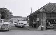
Black-and-white photograph of the view east on Hasell Street from the C. B. Prentiss & Co. Customer Parking Lot and 95 Hasell Street (St. Mary’s Roman Catholic Church). 87 Hasell and 85 Hasell also in view at left.
Four B&W photographs of buildings on the west side of King Street, including 213 King and 215 King, demolished for the construction of Majestic Square: Top left (211-215): 211-213 King (Palmetto Hotel) and 215 King Street (Stephan's); Top right: 197 King Street; Bottom left 193-197: 193 King Street (Colonial Antique Shop), 195 King Street, and 197 King Street; Bottom right (191-197): 191 King Street (Birlant Antiques), 193 King Street, 195 King Street, 197 King Street.
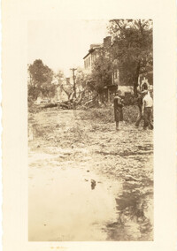
Photograph of Church Street, looking south from the corner of Broad Street at 49 Broad (right foreground), showing the scene on the street after the tornadoes of September 29, 1938. Fallen tree lies across the street; debris and water cover the street. Onlookers are on the street. 105 Church and 107 Church can also be seen.
Photograph of Broad Street, looking west, showing the scene on the street after the tornadoes of September 29, 1938. South side of the 60 block of Broad Street in foreground; St. Michael's Church and the Charleston County Courthouse in the background. Onlookers and vehicles are on the street.
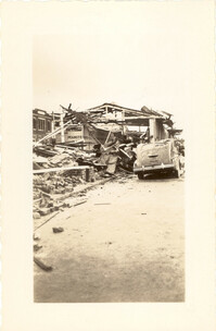
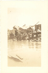
Looking east on Market Street after the tornadoes of September 29, 1938, showing the Market Sheds in ruins. A damaged car is parked along side of the debris. The Old Church of the Redeemer can be seen in the background.
Photograph of Broad Street, looking east at the 60 block, showing the scene on the street after the tornadoes of September 29, 1938. The Daniel Ravenel House (68 Broad Street), the Confederate Home, and the People's Building can be seen at the right; the Old Exchange Building is visible in the background. Onlookers, cars, and a person riding a bicycle are on the street.
Looking northwest on Market Street from the U.S. Custom House on East Bay Street, after the tornadoes of September 29, 1938, showing damaged and ruined Market Sheds. Also shows the damaged buildings on North Market Street. Onlookers and cars are in the street. Partial view of ca. 225 East Bay Street (now gone) is on the left.
Looking north on Church Street from the northeast corner of Chalmers Street. Features buildings on the west side of the street: 129 Church, 131 Church, and the Dock Street Theater). Also in view are buildings on the east side of the street: 18 Chalmers Street, 132 Church Street, and St. Philip's Church). Cars are parked on the street.
One of four maps of King Street building footprints, hand-colored to designate status. This map illustrates the historical significance of buildings on King Street from Calhoun Street to Columbus Street.
View of Charleston from rooftop at northeast corner of Wentworth and Meeting Streets, facing southwest. Church steeples in image include the Unitarian Church and St. John's Lutheran Church. Page 2, Photo 2 of collection. 3.5" x 3.5" B/W photograph.
Black-and-white photograph of the view north on Meeting Street toward Market Street, from the 135 Meeting (Gibbes Art Gallery) and 141 Meeting (Charleston Gas Light Co. Building) at left.
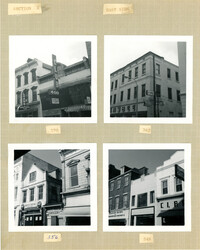
Four B&W photographs of buildings on the east side of King Street: Top left: 220 King Street (Dumas); Top right: 218 King Street (Sharnoff's Uniform Shop); Bottom left (212-218): 212 King Street, 214 King Street (Fabric Center), 216 King Street, and edge of 218 King Street; Bottom right (208-214): 208 King Street (Gatlin Opticians), 212 King Street (La Scaltro Antiques), and 214 King Street (Fabric Center).
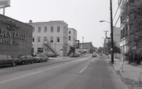
Black-and-white photograph of the view north on Meeting Street toward Market Street, from the parking lot of the White Horse Inn. The Golden Eagle Motor Inn next door is also in view.
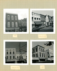
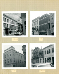
Three B&W photographs of buildings on the west side of King Street, demolished for the construction of Majestic Square: Top left: 223 King Street (Ocean Grill); Top right: 221 King Street (photograph is missing); Bottom left (219-223): 219 King Street (Rice Bros.), 221 King Street, and 223 King Street (Ocean Grill); Bottom right (217-219): 217 King Street and 219 King Street (Rice Bros.).
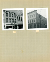
Black-and-white photograph of the view north on Meeting Street toward Market Street, from the Golden Eagle Motor Inn. Madren Paint Co. (177 Meeting) also in view.
Two B&W photographs of buildings on the east side of King Street, both demolished for the construction of Charleston Place: Left (224-226): 224 King Street and 226 King Street (Ritz Hotel); Right: 222 King Street (Copa Lounge) (northeast corner of King and Market).
Four B&W photographs of buildings on the east side of King Street, including some that were demolished for the construction of Charleston Place: Top left (244-246): 244 Coastal Finance Loans and 246 King Street (The Linen Shop) demolished; Top right: 238-242 King Street (J.C. Penney Company) ? demolished; Bottom left (226-230): 226 King Street (Ritz [Hotel]), 228 King Street (Little Town), and 230 King Street demolished; Bottom right: 316 King Street (Rosalie Meyers) [labeled 318 on album page].
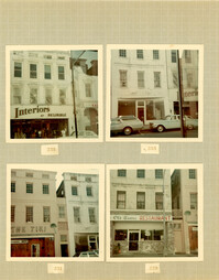
Four color photographs of buildings on the west side of King Street: Top left: 235 King Street (Interiors); Top right: 233 King Street; Bottom left: 231 King Street (The Tiki); Bottom right: 229 King Street (Old Towne Restaurant)
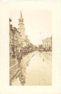
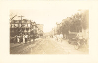
Black-and-white photograph of the view north from the intersection of Meeting Street and Market Street. Madren Paint Co. (177 Meeting) at left; First Citizens Bank (182 Meeting), Market Hall, and 112 North Market at right.
Black-and-white photograph of the northwest elevation of 235 Meeting Street. Shows the corner of Meeting and Hasell Streets and the north elevation of the building that extends west on Hasell Street. "Picture Framing" signage over window. Also shows neighboring buildings to the south in the view down Meeting. (Currently the site of Sticky Fingers Restaurant.)