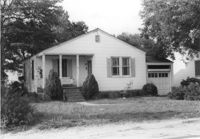
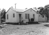
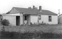
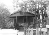
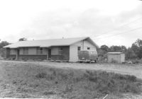
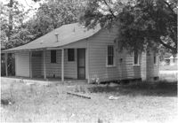
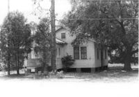
House on Dorchester Road, on site affected by the construction of Interstate 26 (I-26). Building address number 7. Surveyor notations on back of photo: "Dkt.: 10.480. Property owner: Fred M. Skipper. Tract: 179. Station: 132+90 Rt. (Route 642) [Dorchester Road]. Date: May 30, 1961. In R/W - Bought." [See collection description for explanation of surveyor notations.]
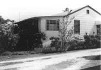
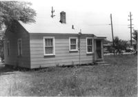
House at curve in road, on site affected by the construction of Interstate 26 (I-26). Surveyor notations on back of photo: "Dkt.: 10.480. Property owner: Mrs. Hazel McSherley Barton. Tract: 185. Station: 5684+65± Rt. (Line D). Date: May 31, 1961. Damage to fence and loss of pine tree." [See collection description for explanation of surveyor notations.]
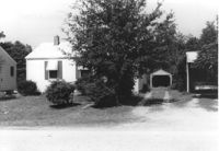
House on corner of Harvey Avenue, on site affected by the construction of Interstate 26 (I-26). Street sign for Harvey Ave. at right. Surveyor notations on back of photo: "Dkt.: 10.480. Property owner: Renkin Finance Co. Tract: 188. Station: 5686+00 Lt. Date: May 31, 1961. In R/W - Bought." [See collection description for explanation of surveyor notations.]
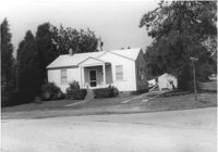
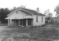
House on Dorchester Road, on site affected by the construction of Interstate 26 (I-26). Surveyor notations on back of photo: "Dkt.: 10.480. Property owner: Mrs. Margaret H. Patterson. Tract: 181. Station: 134+00 (Rt. (Route 642) [Dorchester Road]. Date: May 31, 1961. In R/W - Bought." [See collection description for explanation of surveyor notations.]
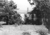
House on site affected by the construction of Interstate 26 (I-26). Partially obscured by trees. Surveyor notations on back of photo: "Dkt.: 10.480. Property owner: Sallie Mae Penninger. Tract: 198. Station: 5688+95 Lt. Date: May 31, 1961. In R/W - Bought." [See collection description for explanation of surveyor notations.]
House on site affected by the construction of Interstate 26 (I-26). Building address number 109. Surveyor notations on back of photo: "Dkt.: 10.480. Property owner: Tujax, Inc. Tract: 283. Station: 5732+70 Lt. (Line B). Date: May 30, 1961. In R/W - Bought." [See collection description for explanation of surveyor notations.]
House on site affected by the construction of Interstate 26 (I-26). Building address number 191. Driveway leads to garage/shed. Surveyor notations on back of photo: "Dkt.: 10.480. Property owner: John S. Singleton. Tract: 132. Station: 5652+80 Rt. Date: May 1, 1961. In R/W - Bought." [See collection description for explanation of surveyor notations.]
House on site affected by the construction of Interstate 26 (I-26). Building address number 209. Surveyor notations on back of photo: "Dkt.: 10.480. Property owner: Donald L. Gibson, et al. Tract: 141. Station: 5658+30 Rt. Date: May 2, 1961. In R/W - Bought." [See collection description for explanation of surveyor notations.]
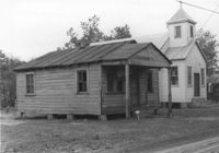
House on site affected by the construction of Interstate 26 (I-26). Neighboring church in background. Surveyor notations on back of photo: "Dkt.: 10.480. Property owner: Joseph Perry. Tract: 35. Station: 5507+40 Lt. Date: May 1, 1961. In R/W - Bought." [See collection description for explanation of surveyor notations.]
House (rear view) on site affected by the construction of Interstate 26 (I-26). Surveyor notations on back of photo: "Dkt.: 10.480. Property owner: Eugene J. Poteat. Tract: 201. Station: 5689+50 Lt. Date: May 31, 1961. In R/W - Bought." [See collection description for explanation of surveyor notations.]
House (rear view) on site affected by the construction of Interstate 26 (I-26). Surveyor notations on back of photo: "Dkt.: 10.480. Property owner: Joseph A. Elsey. Tract: 200. Station: 5689+70 Rt. Date: May 31, 1961. In R/W - Bought." [See collection description for explanation of surveyor notations.]
House on site affected by the construction of Interstate 26 (I-26). Surveyor notations on back of photo: "Dkt.: 10.480. Property owner: Crider O. Murray. Tract: 202. Station: 5689+90 Lt. Date: May 31, 1961. In R/W - Bought." [See collection description for explanation of surveyor notations.]
House on site affected by the construction of Interstate 26 (I-26). Surveyor notations on back of photo: "Dkt.: 10.480. Property owner: Joseph A. Elsey. Tract: 200. Station: 5689+70 Rt. Date: May 31, 1961. In R/W - Bought." [See collection description for explanation of surveyor notations.]
House on site affected by the construction of Interstate 26 (I-26). Possibly on Rivers Avenue. Surveyor notations on back of photo: "Dkt.: 10.486. Property owner: Hubert W. Keller. Tract: 29. Station: 6+80 (Line F). Date: May 30, 1961. Proximity." [See collection description for explanation of surveyor notations.]
House (corner view, rear) on site affected by the construction of Interstate 26 (I-26). Building address number 18. Surveyor notations on back of photo: "Dkt.: 10.480. Property owner: Harry Morse Construction Co. Tract: 196. Station: 5688+00 Lt. Date: May 31, 1961. In R/W - Bought." [See collection description for explanation of surveyor notations.]
House (side view) on site affected by the construction of Interstate 26 (I-26). Partially obscured by trees. Surveyor notations on back of photo: "Dkt.: 10.480. Property owner: Sallie Mae Penninger. Tract: 198. Station: 5688+95 Lt. Date: May 31, 1961. In R/W - Bought." [See collection description for explanation of surveyor notations.]
House on site affected by the construction of Interstate 26 (I-26). Garage/shed at end of driveway. Surveyor notations on back of photo: "Dkt.: 10.480. Property owner: Herbert Jones. Tract: 192. Station: 5687+00 Lt. Date: May 31, 1961. In R/W - Bought." [See collection description for explanation of surveyor notations.]
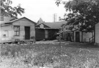
House on site affected by the construction of Interstate 26 (I-26). Neighboring (rear) houses and structures in background. Surveyor notations on back of photo: "Dkt.: 10.480. Property owner: Rochell Dinkins, et al. Tract: 59. Station: 5516+80 Lt. Date: May 1, 1961. In R/W - Bought." [See collection description for explanation of surveyor notations.]
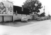
Dorchester Electric Service (side view) on site affected by the construction of Interstate 26 (I-26). Building address number 3640 [possibly Dorchester Road]. Billboard for Swift's Premium Meats for Babies on side of building. Surveyor notations on back of photo: "Dkt.: 10.480. Property owner: Laura B. Beaufort. Tract: 167. Station: 5681+40 Lt. Date: May 30, 1961. In R/W - Bought." [See collection description for explanation of surveyor notations.]
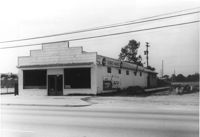
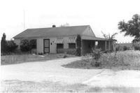
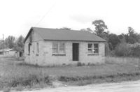
Terrace Market on site affected by the construction of Interstate 26 (I-26). Building is closed. Sunbeam Bread sign on side of building. Front facade has stepped parapet. Surveyor notations on back of photo: "Dkt.: 10.480. Property owner: John C. Gelegotes, et al. Tract: 163. Station: 5681+00 Rt. Date: May 30, 1961. In R/W - Bought." [See collection description for explanation of surveyor notations.]
Rear view of dwellings and other structures on site affected by the construction of Interstate 26 (I-26). Sign for The Spudnut Shop in mid-background. Surveyor notations on back of photo: "Dkt.: 10.480. Property owner: Arlene Phillips, Est. Tract: 165. Station: 5680+75 Lt. Date: May 30, 1961. In R/W - Bought." [See collection description for explanation of surveyor notations.]
House (corner view, rear) on site affected by the construction of Interstate 26 (I-26). Building address number 33. Surveyor notations on back of photo: "Dkt.: 10.480. Property owner: Jesse L. Kennedy. Tract: 290. Station: 5738+85 Rt. (Line B). Date: May 30, 1961. In R/W - Bought." [See collection description for explanation of surveyor notations.]
House (rear view) on site affected by the construction of Interstate 26 (I-26). Building address number 35. Surveyor notations on back of photo: "Dkt.: 10.480. Property owner: Mrs. Helen S. Shuler. Tract: 291. Station: 5738+50 CL. Date: May 30, 1961. In R/W - Bought." [See collection description for explanation of surveyor notations.]
House on site affected by the construction of Interstate 26 (I-26). Building address number 35. Surveyor notations on back of photo: "Dkt.: 10.480. Property owner: Mrs. Helen S. Shuler. Tract: 291. Station: 5738+50 CL Main Line. Date: May 30, 1961. In R/W - Bought." [See collection description for explanation of surveyor notations.]
House (corner view, rear) on site affected by the construction of Interstate 26 (I-26). Surveyor notations on back of photo: "Dkt.: 10.480. Property owner: Mrs. Evelyn R. King. Tract: 288. Station: 5738+80 Lt. (Line B). Date: May 30, 1961. Proximity." [See collection description for explanation of surveyor notations.]
House on site affected by the construction of Interstate 26 (I-26). Surveyor notations on back of photo: "Dkt.: 10.480. Property owner: Mrs. Evelyn R. King. Tract: 288. Station: 5738+80 Lt. (Line B). Date: May 30, 1961. Proximity." [See collection description for explanation of surveyor notations.]
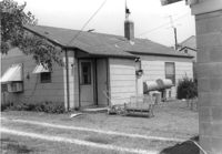
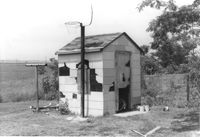
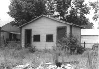
Small shed on site affected by the construction of Interstate 26 (I-26). Surveyor notations on back of photo: "Dkt.: 10.480. Property owner: Harold W. Cone. Tract: 285. Station: 5734+10 Lt. (Line B). Date: May 30, 1961. In R/W - Bought." [See collection description for explanation of surveyor notations.]
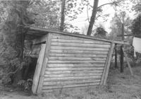
Shed on site affected by the construction of Interstate 26 (I-26). Surveyor notations on back of photo: "Dkt.: 10.480. Property owner: Ruth I. Kirby. Tract: 236. Station: 5699+30 Lt. Date: May 2, 1961. In R/W - Bought." [See collection description for explanation of surveyor notations.]
House on site affected by the construction of Interstate 26 (I-26). Sign over window: Pat's TV and Radio Repair. Surveyor notations on back of photo: "Dkt.: 10.480. Property owner: Boyd E. Patterson. Tract: 153. Station: 5666+80 Rt. Date: May 2, 1961. In R/W - Bought." [See collection description for explanation of surveyor notations.]
House on site affected by the construction of Interstate 26 (I-26). Obscured by trees. Garage/shed at end of driveway. Surveyor notations on back of photo: "Dkt.: 10.480. Property owner: Edward P. Blanton. Tract: 146. Station: 5661+30 Rt. Date: May 2, 1961. In R/W - Bought." [See collection description for explanation of surveyor notations.]
House on site affected by the construction of Interstate 26 (I-26). Royal Crown Cola sign on fence. Surveyor notations on back of photo: "Dkt.: 10.480. Property owner: Central McMillan, et al. Tract: 38. Station: 5508+40 Rt. Date: May 2, 1961. In R/W - Bought." [See collection description for explanation of surveyor notations.]
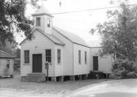
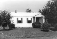
Enah Chapel Church on site affected by the construction of Interstate 26 (I-26). Surveyor notations on back of photo: "Dkt.: 10.480. Property owner: Enoch Methodist Church. Tract: 36. Station: 5507+80 Lt. Date: May 2, 1961. In R/W - Bought." [See collection description for explanation of surveyor notations.]
House on site affected by the construction of Interstate 26 (I-26). Surveyor notations on back of photo: "Dkt.: 10.480. Property owner: Joseph Perry. Tract: 34. Station: 5507+10 Lt. Date: May 2, 1961. In R/W - Bought." [See collection description for explanation of surveyor notations.]
House on site affected by the construction of Interstate 26 (I-26). Building address number 105. Surveyor notations on back of photo: "Dkt.: 10.480. Property owner: Norman Lubesky. Tract: 284. Station: 5733+50 Lt. (Line B). Date: May 30, 1961. In R/W - Bought." [See collection description for explanation of surveyor notations.]
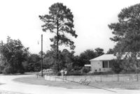
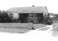
House, possibly duplex, on site affected by the construction of Interstate 26 (I-26). Surveyor notations on back of photo: "Dkt.: 10.480. Property owner: Roy A. Farley, et al. Tract: 102-A. Station: 55+60 Lt. (Goodrich Road). Date: May 2, 1961. Proximity." [See collection description for explanation of surveyor notations.]
House on site affected by the construction of Interstate 26 (I-26). Outbuilding in background. Surveyor notations on back of photo: "Dkt.: 10.480. Property owner: Rosa Bell Harley. Tract: 83. Station: 5521+80 Rt. Date: May 2, 1961. In R/W - Bought." [See collection description for explanation of surveyor notations.]
House on site affected by the construction of Interstate 26 (I-26). Surveyor notations on back of photo: "Dkt.: 10.480. Property owner: Joe Stephens, Est. Tract: 29. Station: 5506+00 Lt. Date: May 1, 1961. In R/W - Bought." [See collection description for explanation of surveyor notations.]
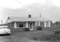
House on site affected by the construction of Interstate 26 (I-26). Surveyor notations on back of photo: "Dkt.: 10.480. Property owner: Evelyn Nelson. Tract: 80. Station: 5519+30 Rt. Date: May 2, 1961. In R/W - Bought." [See collection description for explanation of surveyor notations.]
House (rear view?) and structure (garage or shed) on site affected by the construction of Interstate 26 (I-26). Building address number 1800. Possibly on Rivers Avenue. Surveyor notations on back of photo: "Dkt.: 10.486. Property owner: G.P. Parris, Est. Tract: 6. Station: 9+50 Lt. Date: May 30, 1961. In R/W - Bought." [See collection description for explanation of surveyor notations.]
House (corner view, rear) on site affected by the construction of Interstate 26 (I-26). Building address number 1806. Possibly on Rivers Avenue. Surveyor notations on back of photo: "Dkt.: 10.486. Property owner: Cleve G. Murray. Tract: 12. Station: 10+90 Lt. Date: May 30, 1961. In R/W - Bought." [See collection description for explanation of surveyor notations.]
House on site affected by the construction of Interstate 26 (I-26). Piggly Wiggly store across the street, in background. Possibly on Rivers Avenue. Surveyor notations on back of photo: "Dkt.: 10.486. Property owner: Mrs. Hazel Faulkner. Tract: 9. Station: 10+35 Lt. Date: May 30, 1961. In R/W - Bought." [See collection description for explanation of surveyor notations.]
House on site affected by the construction of Interstate 26 (I-26). Surveyor notations on back of photo: "Dkt.: 10.480. Property owner: Herbert Jones. Tract: 192. Station: 5687+00 Lt. Date: May 31, 1961. In R/W - Bought." [See collection description for explanation of surveyor notations.]
Outbuilding on site affected by the construction of Interstate 26 (I-26). Possibly on Rivers Avenue. Surveyor notations on back of photo: "Dkt.: 10.486. Property owner: Redding F. Moore. Tract: 23, 24, 25. Station: 15+90 Rt. (Line C). Date: May 30, 1961. In R/W - Bought." [See collection description for explanation of surveyor notations.]
House on site affected by the construction of Interstate 26 (I-26). Possibly on Rivers Avenue. Surveyor notations on back of photo: "Dkt.: 10.486. Property owner: Edward R. Livingston. Tract: 17. Station: 12+25 Lt. Date: May 30, 1961. In R/W - Bought." [See collection description for explanation of surveyor notations.]
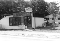
DuMont Television / Patterson's TV & Appliance Service Center / Karts Sales & Service on Dorchester Road, on site affected by the construction of Interstate 26 (I-26). Surveyor notations on back of photo: "Dkt.: 10.480. Property owner: Mrs. Margaret H. Patterson. Tract: 181. Station: 134+15 (Rt. (Route 642) [Dorchester Road]. Date: May 31, 1961. In R/W - Bought." [See collection description for explanation of surveyor notations.]
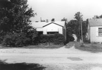
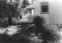
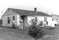
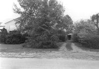
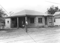
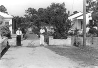
Driveway with low block walls on either side, on site affected by the construction of Interstate 26 (I-26). Two neighboring houses on either side in view. Surveyor notations on back of photo: "Dkt.: 10.480. Property owner: Mrs. Elena B. Pye. Tract: 186. Station: 5685+00 Rt. (Line D). Date: May 31, 1961. Block wall to be moved by SCHD." [See collection description for explanation of surveyor notations.]
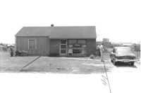
House and shed (rear view) on Dorchester Road, on site affected by the construction of Interstate 26 (I-26). Building address number 9. Surveyor notations on back of photo: "Dkt.: 10.480. Property owner: John H. Schulken, Est. Tract: 180. Station: 133+30 Rt. (Route 642) [Dorchester Road]. Date: May 31, 1961. In R/W - Bought." [See collection description for explanation of surveyor notations.]
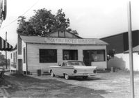
Pick & Pay Bicycle Repair Shop on site affected by the construction of Interstate 26 (I-26). Surveyor notations on back of photo: "Dkt.: 10.480. Property owner: G.S. Carter, Sr. Tract: 166. Station: 5681+50 Lt. Date: May 30, 1961. In R/W - Bought." [See collection description for explanation of surveyor notations.]
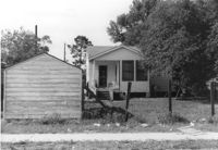
House (rear view) on site affected by the construction of Interstate 26 (I-26). Surveyor notations on back of photo: "Dkt.: 10.480. Property owner: Charlie C. Caldwell. Tract: 195. Station: 5688+50 Rt. Date: May 31, 1961. In R/W - Bought." [See collection description for explanation of surveyor notations.]
House (rear view) on site affected by the construction of Interstate 26 (I-26). Surveyor notations on back of photo: "Dkt.: 10.480. Property owner: Fritz E. Young. Tract: 232. Station: 5697+30 Lt. Date: May 31, 1961. Proximity to rear." [See collection description for explanation of surveyor notations.]