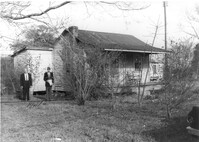
House on site affected by the widening of Route 171 (Folly Road). Surveyor notations on back of photo: "Dkt.: 10.494. Property owner: Sophie Sabel, Est. Tract: 97. Station: 371+20 Lt. Date: Mar. 21, 1962. To be cut off at R/W by SCHD [SC Highway Dept.?]. [See collection description for explanation of surveyor notations.]
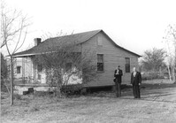
House on site affected by the widening of Route 171 (Folly Road). Surveyor notations on back of photo: "Dkt.: 10.494. Property owner: Sophie Sabel, Est. Tract: 97. Station: 371+20 Lt. Date: Mar. 21, 1962. To be cut off at R/W by SCHD [SC Highway Dept.?]. [See collection description for explanation of surveyor notations.]
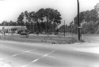
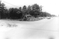
Esso Service Station: at intersection of Orange Grove Road and SC Highway 7 (Sam Rittenberg), on site affected by the widening of Routes 7 & 171. Surveyor notations on back of photo: "Dkt.: 10.551. Property owner: Humble Oil Co. Tract: 1. Station: 36±00 Rt. Date: Jul. 22, 1965. Taken from intersection of Orange Grove Rd. and Rte. 7 & 171. [See collection description for explanation of surveyor notations.]
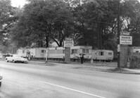
Entrance to Idamor Trailer Park and Apartments, on site affected by the widening of State Road 31 (Reynolds Avenue). Surveyor notations on back of photo: "Dkt.: 10.541. Property owner: Morris P. Sokol, et al. Tract: 1. Station: 3t-4t Lt. Date: Apr. 20, 1965. Taken from southeast side. [See collection description for explanation of surveyor notations.]
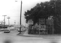
Corner view of Idamor Trailer Park and Apartments, with signage for Commissary Store - Navy Exchange Country Store and for E.M. Club - Eliza Lucas Hall, on site affected by the widening of State Road 31 (Reynolds Avenue). Surveyor notations on back of photo: "Dkt.: 10.541. Property owner: Morris P. Sokol, et al. Tract: 1. Station: 4+8 Lt. Date: Apr. 20, 1965." [See collection description for explanation of surveyor notations.]
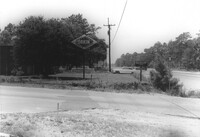
Orkin Pest Control - Termite Control, corner of Ashley Hall Road and Route 7 (Sam Rittenberg Boulevard), on site affected by the widening of Routes 7 & 171. Surveyor notations on back of photo: "Dkt.: 10.551. Property owner: Atlantic Investment & Development Co. Tract: 4. Station: 127±00 Rt. Date: Jul. 22, 1965. Range poles on corners of ? area - photographer standing in Rt. 7. [See collection description for explanation of surveyor notations.]
Orkin Pest Control - Termite Control, corner of Ashley Hall Road and Route 7 (Sam Rittenberg Boulevard), on site affected by the widening of Routes 7 & 171. Surveyor notations on back of photo: "Dkt.: 10.551. Property owner: Atlantic Investment & Development Co. Tract: 4. Station: 127±00 Rt. Date: Jul. 22, 1965. Same as Photo 5, view from across Ashley Hall Rd. looking north. [See collection description for explanation of surveyor notations.]