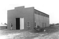
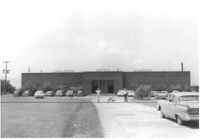
Building (warehouse or other industrial use?) on site affected by the construction of Interstate 26 (I-26). Surveyor notations on back of photo: "Dkt.: 10.480. Property owner: G.S. Carter, Sr. Tract: 162. Station: 5672+00 Lt. CL. Date: May 30, 1961. In R/W - Bought." [See collection description for explanation of surveyor notations.]
Building (warehouse or other industrial use?) on site affected by the construction of Interstate 26 (I-26). Surveyor notations on back of photo: "Dkt.: 10.480. Property owner: G.S. Carter, Sr. Tract: 162. Station: 5672+00 Lt. CL. Date: May 30, 1961. In R/W - Bought." [See collection description for explanation of surveyor notations.]
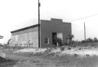
Side view of Paul's Seat Covers (industrial-type building) and its parking lot, on site affected by the construction of Interstate 26 (I-26). Address: 92 Cooper Street. Surveyor notations on back of photo: "Dkt.: 10.517. Property owner: Abe Goldberg. Tract: 66. Station: 5958+20 Lt. - Lane 4. Date: March 5, 1963. In R/W - Bought." [See collection description for explanation of surveyor notations.]
Rear view of industrial use building [National Welders Supply Co. Inc. ] on site affected by the construction of Interstate 26 (I-26). [Building address number 1858.] Welding torches on platform. Surveyor notations on back of photo: "Dkt.: 10.490. Property owner: Minnie R. Sherman. Tract: 115 and 118. Station: 5829+80 Lt. Date: August 29, 1962. Rear of building to be moved by SCHD [SC Highway Department]." [See collection description for explanation of surveyor notations.]
Charleston Supply Company building on site affected by the construction of Interstate 26 (I-26). Surveyor notations on back of photo: "Dkt.: 10.490. Property owner: Commercial Realty Co. Tract: 135. Station: 5837+90 Rt. Date: August 29, 1962. Proximity." [See collection description for explanation of surveyor notations.]
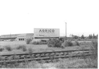
Agrico [fertilizer company] buildings on site affected by the construction of Interstate 26 (I-26). Railroad tracks in foreground. Surveyor notations on back of photo: "Dkt.: 10.490. Property owner: American Agr. Chemical Co. [American Agriculture Chemical Co.]. Tract: 138. Station: ? Date: August 29, 1962. Special damages ["spec. damages]." [See collection description for explanation of surveyor notations.]
Building (industrial use?) on site affected by the widening of State Road 13 (Remount Road). Texaco and Gulf gas stations in background, across street). Surveyor notations on back of photo: "Dkt.: 10.562. Property owner: A.G. Boone Co. Tract: 15. Date: Jul. 12, 1967." [See collection description for explanation of surveyor notations.]
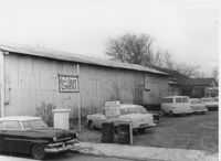
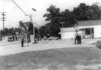
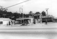
Opal Oil Co., on site affected by the widening of State Road 13 (Remount Road). Gulf gas Station: across the street. Surveyor notations on back of photo: "Dkt.: 10.562. Property owner: Ethel Barnes Morris. Tract: 22. Date: Jul. 12, 1967." [See collection description for explanation of surveyor notations.]
Opal Oil Co., on site affected by the widening of State Road 13 (Remount Road). Surveyor notations on back of photo: "Dkt.: 10.562. Property owner: Ethel Barnes Morris. Tract: 22. Date: Jul. 12, 1967." [See collection description for explanation of surveyor notations.]
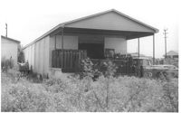
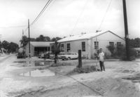
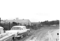
Dirt road and Charleston Oil Co. structures, on site affected by the construction of Interstate 26 (I-26). Surveyor notations on back of photo: "Dkt.: 10.490. Property owner: Charleston Oil Co. Tract: 140 and 140-A. Station: 5861+51 Rt. and Lt. (crosses CL). Date: August 29, 1962. In R/W - Bought." [See collection description for explanation of surveyor notations.]