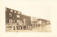
Photograph of the United Fruit Company dock after the September 29, 1938, tornadoes. (Based on Sanborn Maps, the dock was located at the foot of Laurens Street, Southern Railway Pier 2.)
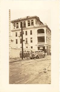
Photograph of the Timrod Hotel [ca. 101 Meeting Street], after the tornadoes of September 29, 1938, showing the damage done to the building. View of the hotel looking north on Meeting Street (southeast elevation). Infantry patrolmen stand on sidewalk by a car. Signage for Byars Drug Store is on the south elevation. [Note: The hotel was later demolished in the 1960s.]
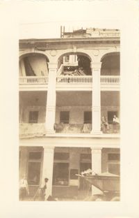
Photograph of the Timrod Hotel [ca. 101 Meeting Street], after the tornadoes of September 29, 1938, showing the damage done to the building. East elevation. Men are sitting on the second story piazza ledge. Men stand on the sidewalk by a truck that is carrying debris. [Note: The hotel was later demolished in the 1960s.]
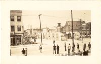
Looking northwest on Market Street from the U.S. Custom House on East Bay Street, after the tornadoes of September 29, 1938, showing damaged and ruined Market Sheds. Also shows the damaged buildings on North Market Street. Onlookers and cars are in the street. Partial view of ca. 225 East Bay Street (now gone) is on the left.
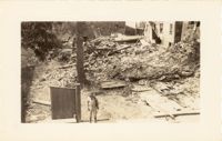
Photograph of the ruins of a building, after the September 29, 1938, tornadoes. Based on newspaper accounts, it is probably the site of 45 State Street. Infantry patrolman stands in foreground.
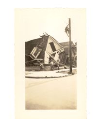
Photograph of the destruction of a house done by the tornadoes of September, 29, 1938. Based on newspaper accounts, the home was probably located in the Fiddlers' Green neighborhood near the Ashley River. Two men lean against the ruins while another man climbs a nearby telephone pole.
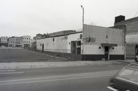
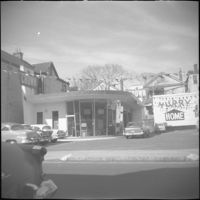
Black-and-white photograph of 199 Meeting Street (Ace Liquors Inc, formerly known as The Horse Shoe bar) and the view west across what was the location of Belk Department Store (232 King Street) and parking lot, now the site of Charleston Place (f/k/a Charleston Center). Shows buildings on the west side of King Street: 231 King, 233 King, 235 King, and 237 King.
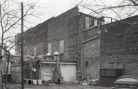
One of three black-and-white photographs of the structures at the rear of 238-242 King Street up to the rear of the buildings at about 199-203 Meeting Street, bordering what was the northern boundary of the Belk parking lot, and on the site where Charleston Center would be constructed.
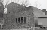
One of three black-and-white photographs of the side elevations of (possibly) 87 Hasell Street and its neighbor to the east at the time, 85 Hasell Street (gone). (87 Hasell Street currently borders the Hasell Street entry to Charleston Place and its parking garage.)