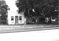
Gas station on site affected by the widening of U.S. Route 17. Presumably located in Mount Pleasant or vicinity. Surveyor notations on back of photo: "Dkt.: 10.597. Property owner: Charles Dingle. Tract: 98. Station 461±50 Rt. Date: Sept. 17, 1968." [See collection description for explanation of surveyor notations.]
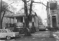
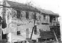
Porch of house with laundry hanging, and lot strewn with scrap wood, on site affected by the construction of the Crosstown. Address: 12 Norman Street. Surveyor notations on back of photo: "Dkt.: 10.524. Property owner: James Alston. Tract: 19. Station: 68+10 Lt. Date: Oct. 13, 1964. Portion in R/W to be removed by property owner." [See collection description for explanation of surveyor notations.]
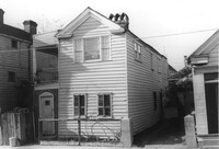
House on site affected by the construction of the Crosstown. Address: 18-20 Wescott Street. Surveyor notations on back of photo: "Dkt.: 10.524. Property owner: Ralph E. Thornley, et al. Tract: 11. Station: 62+10 Lt. Date: Oct. 13, 1964. Portion in R/W to be removed. [See collection description for explanation of surveyor notations.]
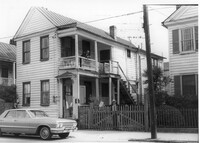
House on site affected by the construction of the Crosstown. Address: 181 Spring Street. Surveyor notations on back of photo: "Dkt.: 10.524. Property owner: Cecelia Elizabeth Cook, Est. Tract: 17. Station: 64+10 Rt. Date: Oct. 13, 1964. Partially In R/W - Bought." [See collection description for explanation of surveyor notations.]
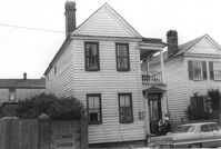
House on site affected by the construction of the Crosstown. Address: 193 Spring Street. Surveyor notations on back of photo: "Dkt.: 10.524. Property owner: Louise A. Robertson. Tract: 13. Station: 23+75 Rt. (Spring Street). Date: Oct. 13, 1964. Portion in R/W to be removed." [See collection description for explanation of surveyor notations.]
House on site affected by the construction of the Crosstown. Address: 193 Spring Street. Surveyor notations on back of photo: "Dkt.: 10.524. Property owner: Louise A. Robertson. Tract: 13. Station: 23+75 Rt. (Spring Street). Date: Oct. 13, 1964. Portion in R/W to be removed." [See collection description for explanation of surveyor notations.]
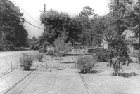
Lot and house (in background) on site affected by the widening of U.S. Route 17. Presumably located in Mount Pleasant or vicinity. Surveyor notations on back of photo: "Dkt.: 10.597. Property owner: Mary B. McConnell. Tract: 71. Station: 427+ Lt. Date: Sept. 17, 1968." [See collection description for explanation of surveyor notations.]
House (rear view) on site affected by the widening of U.S. Route 17. Presumably located in Mount Pleasant or vicinity. Surveyor notations on back of photo: "Dkt.: 10.597. Property owner: Julia B. Simmons. Tract: 54. Station: 301+00 Lt. Date: Sept. 17, 1968." [See collection description for explanation of surveyor notations.]
House on site affected by the construction of the Crosstown. Address: 3 Todd Street. Surveyor notations on back of photo: "Dkt.: 10.524. Property owner: John W. Bonaparte, et al. Tract: 118. Station: 87+75 Rt. Date: Dec. 1, 1964. In R/W - Bought." [See collection description for explanation of surveyor notations.]
House on site affected by the widening of U.S. Route 17. Presumably located in Mount Pleasant or vicinity. Surveyor notations on back of photo: "Dkt.: 10.597. Property owner: Fay Collington, Est. Tract: 46. Station: 285+50 Rt. Date: Sept. 17, 1968." [See collection description for explanation of surveyor notations.]
House on site affected by the construction of the Crosstown. Address: 10 Todd Street. Surveyor notations on back of photo: "Dkt.: 10.524. Property owner: Gabriel W. Bonaparte. Tract: 122. Station: 88+65 Rt. Date: Dec. 2, 1964. In R/W - Bought." [See collection description for explanation of surveyor notations.]
House on site affected by the construction of the Crosstown. Address: 9 Todd Street. Surveyor notations on back of photo: "Dkt.: 10.524. Property owner: Daniel Frasier. Tract: 121. Station: 87+90 Lt. Date: Dec. 2, 1964. Partially in R/W." [See collection description for explanation of surveyor notations.]
House on site affected by the widening of U.S. Route 17. Presumably located in Mount Pleasant or vicinity. Surveyor notations on back of photo: "Dkt.: 10.597. Property owner: Edward Cummings. Tract: 45. Station: 284+50 Rt. Date: Sept. 17, 1968." [See collection description for explanation of surveyor notations.]
House on site affected by the construction of the Crosstown. Address: 7 Todd Street. Surveyor notations on back of photo: "Dkt.: 10.524. Property owner: Daniel Frasier. Tract: 120. Station: 87+90 Lt. Date: Dec. 2, 1964. In R/W - Bought." [See collection description for explanation of surveyor notations.]
Structure on site affected by the construction of the Crosstown. Address: 3 Todd Street. On property of previous photos 413-415. Surveyor notations on back of photo: "Dkt.: 10.524. Property owner: John W. Bonaparte, et al. Tract: 118. Station: 87+35 Rt. Date: Dec. 1, 1964. In R/W - Bought." [See collection description for explanation of surveyor notations.]
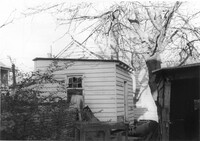
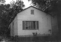
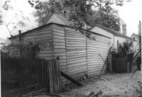
Shed on site affected by the construction of the Crosstown. Address: 119 Sheppard Street. Surveyor notations on back of photo: "Dkt.: 10.524. Property owner: Scott M. Boyle. Tract: 139. Station: 17+25 Rt. N.B. lane. Date: Dec. 2, 1964. Outside R/W." [See collection description for explanation of surveyor notations.]
House (corner view) on site affected by the construction of the Crosstown. Address: 123 Sheppard Street. View of street corner. Surveyor notations on back of photo: "Dkt.: 10.524. Property owner: Salem Baptist Church. Tract: 137. Station: 16+60 CL Rt. N.B. lane. Date: Dec. 2, 1964. In R/W - Bought." [See collection description for explanation of surveyor notations.]
House on site affected by the construction of the Crosstown. Address: 123 Sheppard Street. Surveyor notations on back of photo: "Dkt.: 10.524. Property owner: Salem Baptist Church. Tract: 137. Station: 16+60 CL Rt. N.B. lane. Date: Dec. 2, 1964. In R/W - Bought." [See collection description for explanation of surveyor notations.]
House on site affected by the construction of the Crosstown. Address: 126 Sheppard Street. Surveyor notations on back of photo: "Dkt.: 10.524. Property owner: Nathaniel M. Johnson. Tract: 134. Station: 16+70 Lt. S.B. lane. Date: Dec. 2, 1964. In R/W - Bought." [See collection description for explanation of surveyor notations.]
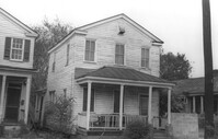
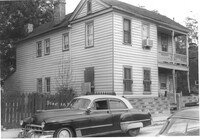
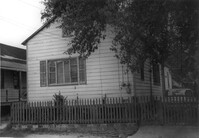
House on site affected by the construction of the Crosstown. Address: 157 President Street. Surveyor notations on back of photo: "Dkt.: 10.524. Property owner: Willie Brooks, et al. Tract: 36. Station: 69+00 Lt. Date: Oct. 14, 1964. In R/W - Bought." [See collection description for explanation of surveyor notations.]
House on site affected by the construction of the Crosstown. Address: 157 President Street. Surveyor notations on back of photo: "Dkt.: 10.524. Property owner: Willie Brooks, et al. Tract: 36. Station: 69+00 Lt. Date: Oct. 14, 1964. In R/W - Bought." [See collection description for explanation of surveyor notations.]
House on site affected by the construction of the Crosstown. Address: 119 Bogard Street (rear). Surveyor notations on back of photo: "Dkt.: 10.524. Property owner: Rebecca S. Cooper. Tract: 55. Station: 73+60 Rt. Date: Oct. 14, 1964. In R/W - Bought." [See collection description for explanation of surveyor notations.]
House on site affected by the construction of the Crosstown. Address: 162 President Street. Surveyor notations on back of photo: "Dkt.: 10.524. Property owner: Emily M. Simmons. Tract: 40. Station: 70+35 Lt. Date: Oct. 14, 1964. In R/W - Bought." [See collection description for explanation of surveyor notations.]
House on site affected by the construction of the Crosstown. Address: 152 President Street. Surveyor notations on back of photo: "Dkt.: 10.524. Property owner: Warren O. Pinckney. Tract: 38. Station: 69+60 Rt. Date: Oct. 14, 1964. Proximity." [See collection description for explanation of surveyor notations.]
House (side view, rear) on site affected by the construction of the Crosstown. Address: 3 Todd Street. Surveyor notations on back of photo: "Dkt.: 10.524. Property owner: John W. Bonaparte, et al. Tract: 118. Station: 87+75 Rt. Date: Dec. 1, 1964. In R/W - Bought." [See collection description for explanation of surveyor notations.]
Houses (partial view) on site affected by the construction of the Crosstown. Address: 152-150 Line Street. Surveyor notations on back of photo: "Dkt.: 10.524. Property owner: John N. Peeksen. Tract: 117. Station: 86+70 Rt. Date: Dec. 1, 1964. In R/W." [See collection description for explanation of surveyor notations.]
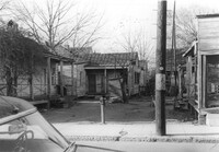
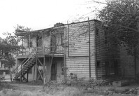
"Panoramic view" of houses on site affected by the construction of the Crosstown. Address: 152-150 Line Street. Surveyor notations on back of photo: "Dkt.: 10.524. Property owner: John N. Peeksen. Tract: 117. Station: 86+70 Rt. Date: Dec. 1, 1964. Panoramic View." [See collection description for explanation of surveyor notations.]
House on site affected by the construction of the Crosstown. Address: 10 Todd Street. Surveyor notations on back of photo: "Dkt.: 10.524. Property owner: Gabriel W. Bonaparte. Tract: 122. Station: 88+65 Rt. Date: Dec. 2, 1964. In R/W - Bought." [See collection description for explanation of surveyor notations.]
House on site affected by the construction of the Crosstown. Address: 8 Norman Street. Surveyor notations on back of photo: "Dkt.: 10.524. Property owner: Cassandra C. Curry. Tract: 21. Station: 67+30 Lt. Date: Oct. 13, 1964. In R/W - Bought." [See collection description for explanation of surveyor notations.]
House on site affected by the construction of the Crosstown. Address: 8 Norman Street. Surveyor notations on back of photo: "Dkt.: 10.524. Property owner: Cassandra C. Curry. Tract: 21. Station: 67+30 Lt. Date: Oct. 13, 1964. In R/W - Bought." [See collection description for explanation of surveyor notations.]
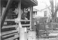
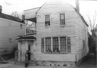
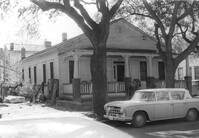
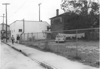
Building (rear view) and lot on site affected by the construction of the Crosstown. Address: 188 Spring Street. View looking towards street corner. Surveyor notations on back of photo: "Dkt.: 10.524. Property owner: E.H. Heidman, Est. Tract: 18. Station: 24+ Lt. (Spring Street). Date: Oct. 13, 1964." [See collection description for explanation of surveyor notations.]
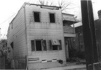
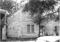
Building, on site affected by the construction of the Crosstown. Address: 188½ Spring Street [188 Spring Street]. Front facade has stepped parapet. Surveyor notations on back of photo: "Dkt.: 10.524. Property owner: E.H. Heidman, Est. Tract: 18. Station: 24+ Lt. (Spring Street). Date: Oct. 13, 1964." [See collection description for explanation of surveyor notations.]
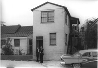
Building on site affected by the construction of the Crosstown. Address: 188 Spring Street. View of street corner. Surveyor notations on back of photo: "Dkt.: 10.524. Property owner: E.H. Heidman, Est. Tract: 18. Station: 24+ Lt. (Spring Street). Date: Oct. 13, 1964." [See collection description for explanation of surveyor notations.]
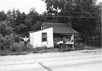
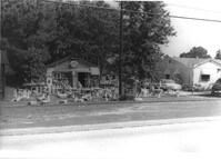
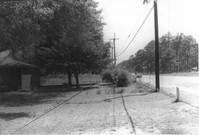
Roadside gift shop on site affected by the widening of U.S. Route 17. Lots of statuary on lot in front of structure. Presumably located in Mount Pleasant or vicinity. Surveyor notations on back of photo: "Dkt.: 10.439. Property owner: Adolph Benton, et al. Tract: 8. Station: 236+00 Rt. Date: Jul. 22, 1965. Range poles on 33' & 50' R/W - Cond." [See collection description for explanation of surveyor notations.]
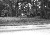
Lot and house (obscured by trees) on site affected by the widening of U.S. Route 17. Presumably located in Mount Pleasant or vicinity. Surveyor notations on back of photo: "Dkt.: 10.439. Property owner: Adolph Benton, et al. Tract: 8. Station: 234+73 to 236+73 Rt. Date: Jul. 22, 1965. Range poles on 33' & 50' R/W - Cond." [See collection description for explanation of surveyor notations.]
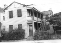
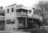
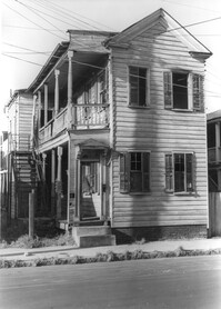
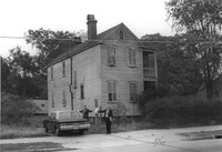
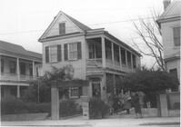
House (boarding house and tea room) on site affected by the construction of the Crosstown. Address: 199 Spring Street. Shows neon sign for Tea Room and signage advertising furnished rooms for rent. Surveyor notations on back of photo: "Dkt.: 10.524. Property owner: Elias A. Johnson, Sr. Tract: 171. Station: 22+45 Rt. Spring Street. Date: Dec. 2, 1964." [See collection description for explanation of surveyor notations.]
House (barely visible) and lot on site affected by the widening of U.S. Route 17. Presumably located in Mount Pleasant or vicinity. Surveyor notations on back of photo: "Dkt.: 10.439. Property owner: Willard B. Causey. Tract: 5. Station: 231+85 Rt. Date: Jul. 22, 1965. Proximity." [See collection description for explanation of surveyor notations.]
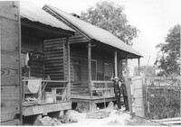
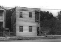
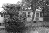
House (rear view) on site affected by the construction of the Crosstown. Address: 81 Kracke Street. Surveyor notations on back of photo: "Dkt.: 10.524. Property owner: Jerry M. Devoe. Tract: 69. Station: 77+80 Lt. Date: Oct. 14, 1964. In R/W - Bought." [See collection description for explanation of surveyor notations.]
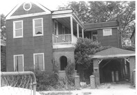
House on site affected by the construction of the Crosstown. Address: 265 Ashley Avenue. Surveyor notations on back of photo: "Dkt.: 10.524. Property owner: William A. Dart, et al. Tract: 80. Station: 78+90 CL Rt. Date: Oct. 14, 1964. In R/W - Bought." [See collection description for explanation of surveyor notations.]
Houses on site affected by the construction of the Crosstown. Address: 81 Kracke Street. Surveyor notations on back of photo: "Dkt.: 10.524. Property owner: Jerry M. Devoe. Tract: 69. Station: 77+40 Lt. Date: Oct. 14, 1964. In R/W - Bought." [See collection description for explanation of surveyor notations.]
House on site affected by the construction of the Crosstown. Address: 81 Kracke Street. Surveyor notations on back of photo: "Dkt.: 10.524. Property owner: Jerry M. Devoe. Tract: 69. Station: 77+80 Lt. Date: Oct. 14, 1964. In R/W - Bought." [See collection description for explanation of surveyor notations.]
Rear view of structure on site affected by the construction of the Crosstown. Address: 81 Kracke Street. Surveyor notations on back of photo: "Dkt.: 10.524. Property owner: Jerry M. Devoe. Tract: 69. Station: 77+40 Lt. Date: Oct. 14, 1964. In R/W - Bought." [See collection description for explanation of surveyor notations.]
House (boarding house and tea room) on site affected by the construction of the Crosstown. Address: 199 Spring Street. Shows neon sign for Tea Room and signage advertising furnished rooms for rent. Surveyor notations on back of photo: "Dkt.: 10.524. Property owner: Elias A. Johnson, Sr. Tract: 171. Station: 22+45 Rt. Spring Street. Date: Dec. 2, 1964." [See collection description for explanation of surveyor notations.]
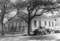
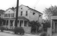
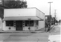
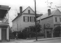
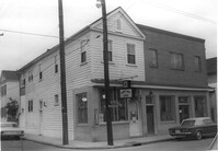
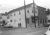
Building (corner view), on site affected by the construction of the Crosstown. Address: 207 Spring Street. Sew-U-Save Shop. View of street corner (corner of Spring Street and Courtenay Street). Surveyor notations on back of photo: "Dkt.: 10.524. Property owner: Olympia Papaeilidow. Tract: 167. Station: 20+35 Rt. Spring Street. Date: Dec. 2, 1964." [See collection description for explanation of surveyor notations.]
Building (corner view), on site affected by the construction of the Crosstown. Address: 207 Spring Street. Sew-U-Save Shop. View of street corner (corner of Spring Street and Courtenay Street). Surveyor notations on back of photo: "Dkt.: 10.524. Property owner: Olympia Papaeilidow. Tract: 167. Station: 20+35 Rt. Spring Street. Date: Dec. 2, 1964." [See collection description for explanation of surveyor notations.]
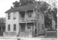
House on site affected by the construction of the Crosstown. Address: 211 Spring Street. "Furnished Rooms" sign posted by door. Surveyor notations on back of photo: "Dkt.: 10.524. Property owner: Freda C. Doscher. Tract: 165. Station: 19+70 Rt. Spring Street. Date: Dec. 2, 1964. Condemned." [See collection description for explanation of surveyor notations.]
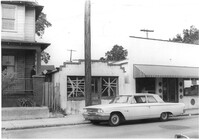
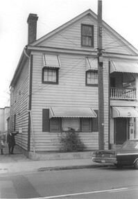
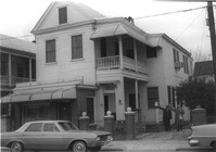
House on site affected by the construction of the Crosstown. Address: 203 Spring Street. First story is Riley's Beauty Shop. Surveyor notations on back of photo: "Dkt.: 10.524. Property owner: Samuel Riley. Tract: 169. Station: 21+65 Rt. Spring Street. Date: Dec. 2, 1964. Condemned." [See collection description for explanation of surveyor notations.]
House and carport on site affected by the construction of the Crosstown. Address: 4 Norman Street. Surveyor notations on back of photo: "Dkt.: 10.524. Property owner: Madeline B. Allen, et al. Tract: 23. Station: 66+55 Lt. Date: Oct. 13, 1964. In R/W - Bought." [See collection description for explanation of surveyor notations.]
House (side view) on site affected by the construction of the Crosstown. Address: 162 President Street. Surveyor notations on back of photo: "Dkt.: 10.524. Property owner: Emily M. Simmons. Tract: 40. Station: 70+35 Lt. Date: Oct. 14, 1964. In R/W - Bought." [See collection description for explanation of surveyor notations.]
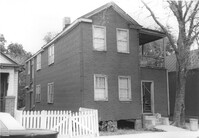
House on site affected by the construction of the Crosstown. Address: 129 Bogard Street. Surveyor notations on back of photo: "Dkt.: 10.524. Property owner: Maxine T. Freidenberg. Tract: 45. Station: 72+10 Lt. Date: Oct. 14, 1964. Portion in R/W to be removed." [See collection description for explanation of surveyor notations.]