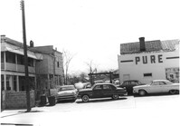
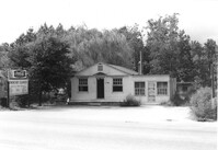
Pure Gas Station: and neighboring house, on site affected by the construction of the Crosstown. Address: 522 Meeting Street. Surveyor notations on back of photo: "Dkt.: 10.518. Property owner: Pure Oil Co. Tract: 1. Station: 38+40 on CL S.B. lane Route 17. Date: Mar. 6, 1963. In R/W - Bought. [See collection description for explanation of surveyor notations.]
Pure Gas Station: and neighboring house, on site affected by the construction of the Crosstown. Address: 522 Meeting Street. Surveyor notations on back of photo: "Dkt.: 10.518. Property owner: Pure Oil Co. Tract: 1. Station: 38+40 on CL S.B. lane Route 17. Date: Mar. 6, 1963. In R/W - Bought. [See collection description for explanation of surveyor notations.]
Building on site affected by the construction of Interstate 26 (I-26). May have been a barber shop (striped pole posted by door). Building address number 1818. Langston Motors in background. Possibly on Rivers Avenue. Surveyor notations on back of photo: "Dkt.: 10.486. Property owner: Dora Peagler. Tract: 20. Station: 13+50 Rt. Date: May 30, 1961. In R/W - Bought." [See collection description for explanation of surveyor notations.]
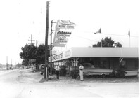
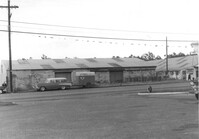
Marine Center (boat sales) on site affected by the construction of Interstate 26 (I-26). Address 4752 Rivers Avenue. View of street corner. C & R Motors in background. Possibly on Rivers Avenue. Surveyor notations on back of photo: "Dkt.: 10.486. Property owner: C.W. Keller. Tract: 33. Station: 2+75 Lt. (Line E). Date: May 30, 1961. Sign to be moved." [See collection description for explanation of surveyor notations.]
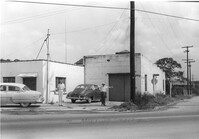
Building on site affected by the construction of Interstate 26 (I-26). On corner of Meeting Street and ? View of street corner. Surveyor notations on back of photo: "Dkt.: 10.510. Property owner: Ada M. Crosby Life Est. Tract: 66-C. Station: 5810+60 Lt. Line B (Meeting Street). Date: Sept. 12, 1962. Proximity." [See collection description for explanation of surveyor notations.]
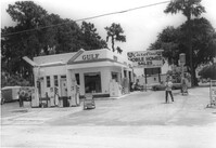
Gulf gas station, on site affected by the widening of State Road 13 (Remount Road). Surveyor notations on back of photo: "Dkt.: 10.562. Property owner: E.R. Gassman. Tract: 1. Date: Jul. 12, 1967." [See collection description for explanation of surveyor notations.]
Renken Boat Co, on site affected by the widening of Route 171 (Folly Road). Surveyor notations on back of photo: "Dkt.: 10.494. Property owner: Renken Finance Co. Tract: 19. Station: 157+00 Lt. Date: Mar. 21, 1962. Proximity. [See collection description for explanation of surveyor notations.]
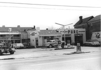
Gulf gas station on site affected by the construction of Interstate 26 (I-26). Surveyor notations on back of photo: "Dkt.: 10.471. Property owner: W.W. Holcombe. Tract: 109. Station: 5380+00 Lt. Date: Aug. 23, 1960. Proximity." [See collection description for explanation of surveyor notations.]
Owen's Dry Cleaners, on site affected by the construction of Interstate 26 (I-26). Building address number 2160. Surveyor notations on back of photo: "Dkt.: 10.471. Property owner: Willa W.S. Owens. Tract: 136. Station: 5477+80 Lt. Date: Aug. 23, 1960. In R/W - Bought." [See collection description for explanation of surveyor notations.]
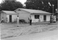
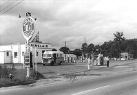
Sinclair gasoline station on site affected by the construction of Interstate 26 (I-26). Surveyor notations on back of photo: "Dkt.: 10.471. Property owner: Sinclair Refining Co. Tract: 138. Station: 1+50 Rt. (Remount Road). Date: Aug. 23, 1960. Proximity." [See collection description for explanation of surveyor notations.]