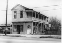
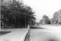
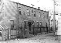
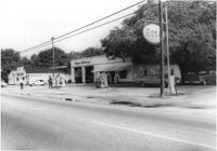
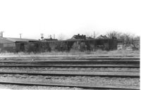
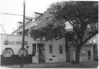
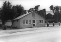
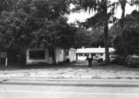
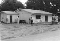
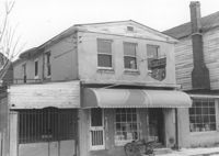
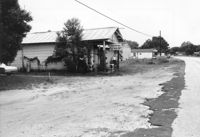
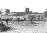
Side view of corner grocery store on site affected by the construction of the Crosstown. Address: 121 America Street. Surveyor notations on back of photo: "Dkt.: 10.518. Property owner: Vallie Talbert. Tract: 58. Station: 49+50 Lt. N.B. lane Route 17. Date: Mar. 7, 1963." [See collection description for explanation of surveyor notations.]
Infinger's Shoe Service on site affected by the construction of Interstate 26 (I-26). Address: 508 Meeting Street. Surveyor notations on back of photo: "Dkt.: 10.517. Property owner: Pandora Co. Tract: 63. Station: 5963+00 CL - Line 6. Date: March 5, 1963. Partially in R/W." [See collection description for explanation of surveyor notations.]
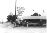
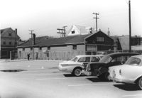
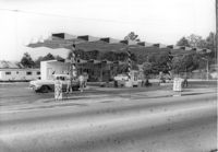
Marine Center (boat sales) on site affected by the construction of Interstate 26 (I-26). Address 4752 Rivers Avenue. View of street corner. C & R Motors in background. Possibly on Rivers Avenue. Surveyor notations on back of photo: "Dkt.: 10.486. Property owner: C.W. Keller. Tract: 33. Station: 2+75 Lt. (Line E). Date: May 30, 1961. Sign to be moved." [See collection description for explanation of surveyor notations.]
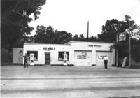
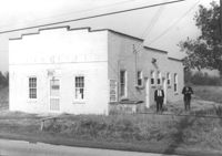
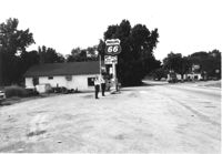
Humble gas station / Esso gas station on site affected by the widening of U.S. Route 17. Ed Cummings, proprietor. Presumably located in Mount Pleasant or vicinity. Surveyor notations on back of photo: "Dkt.: 10.597. Property owner: Edward Cummings. Tract: 37. Station: 285+20 Lt. Date: Sept. 17, 1968." [See collection description for explanation of surveyor notations.]
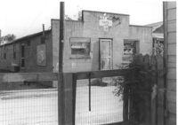
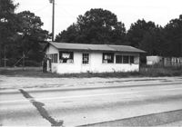
Building on site affected by the widening of U.S. Route 17. Front facade has stepped parapet. Appears to have previously been a business. Presumably located in Mount Pleasant or vicinity. Surveyor notations on back of photo: "Dkt.: 10.597. Property owner: Leon Burns, et al. Tract: 5. Station: 265± Lt. looking south. Date: Sept. 17, 1968." [See collection description for explanation of surveyor notations.]
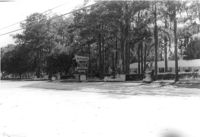
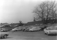
Lot in front of Mt. Pleasant Motel, on site affected by the widening of U.S. Route 17. Presumably located in Mount Pleasant or vicinity. Surveyor notations on back of photo: "Dkt.: 10.439. Property owner: George A. Kaiser, et al. Tract: 16. Station: 225+51 to 228+52 Lt. Date: Jul. 22, 1965. Taken from west side showing range poles on 50' R/W & brick columns on 33' R/W - Cond." [See collection description for explanation of surveyor notations.]
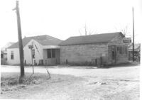
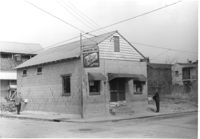
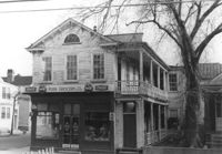
Building, on site affected by the widening of Route 171 (Folly Road). Dave Richardson and Son General Contractor. Front facade has stepped parapet. Surveyor notations on back of photo: "Dkt.: 10.494. Property owner: Dave Richardson, et al. Tract: 93. Station: 314+40 Lt. Date: Mar. 21, 1962. To be cut off at R/W by SCHD [SC Highway Department?]. [See collection description for explanation of surveyor notations.]
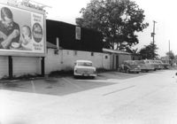
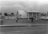
Buildings and parking lot on site affected by the construction of the Crosstown. Address: 626 King Street. Surveyor notations on back of photo: "Dkt.: 10.518. Property owner: Sands & Co. Tract: 16. Station: 9+50 Lt. Line Street (Line #2). Date: Mar. 6, 1963." [See collection description for explanation of surveyor notations.]
Half Moon Cafe on site affected by the construction of Interstate 26 (I-26). Front facade has stepped parapet. Building address number 1995. Surveyor notations on back of photo: "Dkt.: 10.490. Property owner: Illa G. Feldman. Tract: 35. Station: 5796+30 Rt. and Lt. Line 'A'. Date: September 11, 1962. In R/W - Bought." [See collection description for explanation of surveyor notations.]
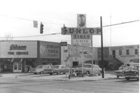
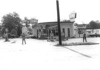
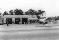
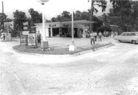
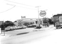
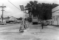
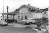
Gibson Tire Service on site affected by the construction of Interstate 26 (I-26). Address: 521 Meeting Street or 523 Meeting Street. Corner of Meeting Street and Lee Street. Sign for Dunlop Tires. View from street corner, showing intersection with directional signage for Route 17 and Route 701 and distances to nearby towns. Surveyor notations on back of photo: "Dkt.: 10.517. Property owner: Thomas P. Gibson. Tract: 59. Station: 36±00 - 37±00 Rt. & Lt. Route 17. Date: February 21, 1963. All in R/W." [See collection description for explanation of surveyor notations.]
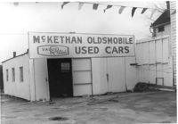
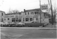
McKethan Oldsmobile / Used Cars / Value Rated, on site affected by the construction of Interstate 26 (I-26). Address: 646 King Street, southeast corner of Sheppard Street and King Street. Surveyor notations on back of photo: "Dkt.: 10.517. Property owner: W.L. McCrary, et al. Tract: 79. Station: 29+40 CL - Northbound Lane. Date: March 5, 1963. In R/W - Bought." [See collection description for explanation of surveyor notations.]
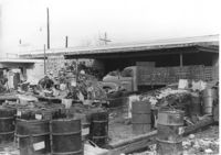
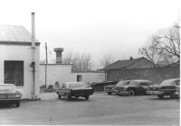
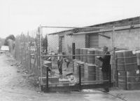
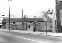
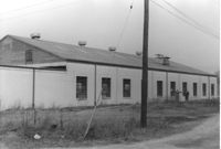
Commercial or industrial building (rear view) on site affected by the construction of Interstate 26 (I-26). Address: 71 Sheppard Street. Trash, scraps, and oil drums in foreground. Surveyor notations on back of photo: "Dkt.: 10.517. Property owner: Alex Goldberg, et al. Tract: 76. Station: 30+45 CL - Northbound Lane. Date: March 5, 1963. All in R/W." [See collection description for explanation of surveyor notations.]
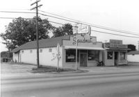
The Spudnut Shop [3646 Dorchester Road], on site affected by the construction of Interstate 26 (I-26). Front facade has stepped parapet. Neighboring building, Pick & Pay Grocery, also in photo. Surveyor notations on back of photo: "Dkt.: 10.480. Property owner: John C. Gelegotes, et al. Tract: 164. Station: 5681+50 on CL. Date: May 30, 1961. In R/W - Bought." [See collection description for explanation of surveyor notations.]
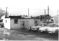
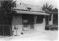
Corner grocery store? (side view) on site affected by the construction of Interstate 26 (I-26). Address: 506 Meeting Street (northwest corner of Meeting Street and Sheppard Street). Signage for a gas station in background (partially visible). Surveyor notations on back of photo: "Dkt.: 10.517. Property owner: Rose D. Brady. Tract 64. Station: 5963+50 Lt. - Line 6. Date: March 5, 1963. Partially in R/W." [See collection description for explanation of surveyor notations.]
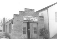
Collins Auto Glass Service on site affected by the construction of Interstate 26 (I-26). Address: 91 Lee Street. Front facade has stepped parapet. Surveyor notations on back of photo: "Dkt.: 10.517. Property owner: W.H. Yon. Tract: 56. Station: 34+30 Lt. - Route 17. Date: February 21, 1963." [See collection description for explanation of surveyor notations.]
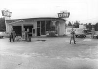
Crown gas station, on site affected by the widening of State Road 13 (Remount Road). Johnny's in back. Possibly the corner of North Rhett Avenue and Remount Road. Surveyor notations on back of photo: "Dkt.: 10.562. Property owner: Corco Realty Co. (Crown). Tract: 142. Date: Jul. 19, 1967." [See collection description for explanation of surveyor notations.]
Crown gas station, on site affected by the widening of State Road 13 (Remount Road). Possibly the corner of North Rhett Avenue and Remount Road. Surveyor notations on back of photo: "Dkt.: 10.562. Property owner: Corco Realty Co. (Crown). Tract: 142. Date: Jul. 19, 1967." [See collection description for explanation of surveyor notations.]
Esso gas station, on site affected by the widening of State Road 13 (Remount Road). Louie's Speed shop in background. Surveyor notations on back of photo: "Dkt.: 10.562. Property owner: Harry R. Williams. Tract: 113. Date: Jul. 19, 1967." [See collection description for explanation of surveyor notations.]
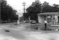
Atlantic gas station, on site affected by the widening of State Road 13 (Remount Road). Surveyor notations on back of photo: "Dkt.: 10.562. Property owner: Atlantic Refining Co. Tract: 37. Date: Jul. 19, 1967." [See collection description for explanation of surveyor notations.]
Joe Smith's Grocery, at the corner of Doscher Avenue and Farwell Street, on site affected by the construction of Interstate 26 (I-26). [Building address number 1934.] House to its rear also in photo. Surveyor notations on back of photo: "Dkt.: 10.490. Property owner: Joseph F. Smith. Tract: 21. Station: 5819+00 Rt. Line "G." Date: March 22, 1962. In R/W - Bought." [See collection description for explanation of surveyor notations.]
Joe Smith's Grocery [at the corner of Doscher Avenue and Farwell Street] on site affected by the construction of Interstate 26 (I-26). Building address number 1934. Surveyor notations on back of photo: "Dkt.: 10.490. Property owner: Joseph F. Smith. Tract: 21. Station: 5819+00 Rt. Line "G." Date: March 22, 1962. In R/W - Bought." [See collection description for explanation of surveyor notations.]
Lot with railroad tracks in foreground, behind Lafayette Motors, on site affected by the construction of Interstate 26 (I-26). Address: 680 King Street. Surveyor notations on back of photo: "Dkt.: 10.517. Property owner: Raymond A. Wittschen. Tract: 122. Station: 31± to 32± Rt. & Lt. Southbound Lane Route 17. Date: March 5, 1963." [See collection description for explanation of surveyor notations.]
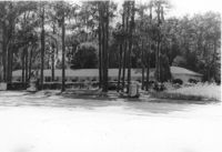
Mt. Pleasant Motel, on site affected by the widening of U.S. Route 17. Presumably located in Mount Pleasant or vicinity. Surveyor notations on back of photo: "Dkt.: 10.439. Property owner: George A. Kaiser, et al. Tract: 16. Station: 225+51 to 228+52 Lt. Date: Jul. 22, 1965. From across road showing brick columns on 33' R/W & range poles on 50' R/W - Cond." [See collection description for explanation of surveyor notations.]
Mt. Pleasant Motel, on site affected by the widening of U.S. Route 17. Presumably located in Mount Pleasant or vicinity. Surveyor notations on back of photo: "Dkt.: 10.439. Property owner: George A. Kaiser, et al. Tract: 16. Station: 228+52 Lt. Date: Jul. 22, 1965. Taken from east side with brick columns on 33' R/W & range poles on 50' R/W - Cond." [See collection description for explanation of surveyor notations.]
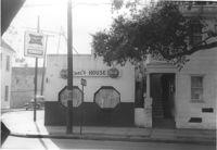
Carl's House on site affected by the construction of the Crosstown. Address: 493 Rutledge Avenue. View of street corner. Neighboring house in photo. Surveyor notations on back of photo: "Dkt.: 10.524. Property owner: Elise C. Goldberg, et al. Tract: 105. Station: 84+40 Rt. Date: Dec. 1, 1964. In R/W - Bought." [See collection description for explanation of surveyor notations.]
House and neighboring houses on site affected by the construction of the Crosstown. Address: 495 Rutledge Avenue and 497 Rutledge Avenue. Surveyor notations on back of photo: "Dkt.: 10.524. Property owner: Elise C. Goldberg, et al. Tract: 105. Station: 84+15 Rt. Date: Dec. 1, 1964. In R/W - Bought." [See collection description for explanation of surveyor notations.]
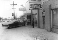
Arrow Restaurant and Trucker's Billiard Academy, on site affected by the widening of State Road 13 (Remount Road). Surveyor notations on back of photo: "Dkt.: 10.562. Property owner: F.L. Parks, Jr. Tract: 3. Date: Jul. 12, 1967." [See collection description for explanation of surveyor notations.]
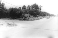
Orkin Pest Control - Termite Control, corner of Ashley Hall Road and Route 7 (Sam Rittenberg Boulevard), on site affected by the widening of Routes 7 & 171. Surveyor notations on back of photo: "Dkt.: 10.551. Property owner: Atlantic Investment & Development Co. Tract: 4. Station: 127±00 Rt. Date: Jul. 22, 1965. Range poles on corners of ? area - photographer standing in Rt. 7. [See collection description for explanation of surveyor notations.]
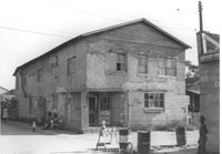
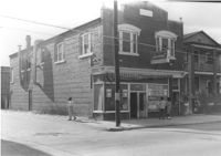
Building on site affected by the construction of Interstate 26 (I-26). View of street corner. Appears to previously have been a corner store named "Upper 10," perhaps with residence on second floor. Surveyor notations on back of photo: "Dkt.: 10.490. Property owner: Robert Martin. Tract: 38. Station: 5957+45 on CL Line 'G'. Date: September 11, 1962. In R/W - Bought." [See collection description for explanation of surveyor notations.]
Parking lot of Ray Waits Mechanic/Body Shop, on site affected by the construction of Interstate 26 (I-26). Address: 11 Walnut Street. Surveyor notations on back of photo: "Dkt.: 10.517. Property owner: Roy Waites [sic] Motors, Inc. Tract: 45. Station: 5949+01 ±Rt. & lt. - Line 6. Date: February 21, 1963." [See collection description for explanation of surveyor notations.]
Ray Waits Mechanic/Body Shop (one end of building, front) on site affected by the construction of Interstate 26 (I-26). Address: 11 Walnut Street. Surveyor notations on back of photo: "Dkt.: 10.517. Property owner: Roy Waites [sic] Motors, Inc. Tract: 45. Station: 5950+70 Rt. - Line 6. Date: February 21, 1963. All in R/W." [See collection description for explanation of surveyor notations.]
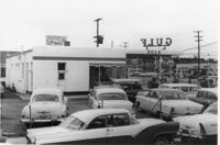
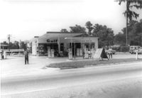
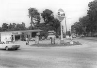
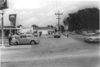
Gulf gas station (side view) on site affected by the construction of Interstate 26 (I-26). Address: 505 Meeting Street. Several parked cars in foreground. Surveyor notations on back of photo: "Dkt.: 10.517. Property owner: Gulf Oil Co. Tract 72. Station: 5960+40 CL - Line 4. Date: March 5, 1963. In R/W - Bought." [See collection description for explanation of surveyor notations.]
Paul's Seat Covers (industrial-type building) on site affected by the construction of Interstate 26 (I-26). Address: 92 Cooper Street. (Appears to be to the right of house in previous photos.) Surveyor notations on back of photo: "Dkt.: 10.517. Property owner: Abe Goldberg. Tract: 66. Station: 5958+20 Lt. - Lane 4. Date: March 5, 1963. In R/W - Bought." [See collection description for explanation of surveyor notations.]
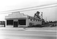
Dorchester Electric Service (side view) on site affected by the construction of Interstate 26 (I-26). Building address number 3640 [possibly Dorchester Road]. Billboard for Swift's Premium Meats for Babies on side of building. Surveyor notations on back of photo: "Dkt.: 10.480. Property owner: Laura B. Beaufort. Tract: 167. Station: 5681+40 Lt. Date: May 30, 1961. In R/W - Bought." [See collection description for explanation of surveyor notations.]
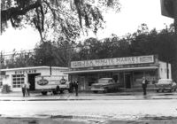
Terrace Market on site affected by the construction of Interstate 26 (I-26). Building is closed. Sunbeam Bread sign on side of building. Front facade has stepped parapet. Surveyor notations on back of photo: "Dkt.: 10.480. Property owner: John C. Gelegotes, et al. Tract: 163. Station: 5681+00 Rt. Date: May 30, 1961. In R/W - Bought." [See collection description for explanation of surveyor notations.]
Laundromat / Half Hour Laundry on site affected by the construction of Interstate 26 (I-26). Address: 1085 Meeting Street. View of street corner. Surveyor notations on back of photo: "Dkt.: 10.503. Property owner: Gussie Feldman. Tract: 41. Station: 5903+50 Lt. Date: Feb. 19, 1963. In R/W - Bought." [See collection description for explanation of surveyor notations.]
Phillips 66 gas station on site affected by the widening of U.S. Route 17. Gulf gas station in background. Presumably located in southern Charleston County. Surveyor notations on back of photo: "Dkt.: 10.600. Property owner: Nora Bishop Carmichael. Tract: 18. Station: 608±40 Lt. Date: Sept. 18, 1968." [See collection description for explanation of surveyor notations.]
Kentucky Fried Chicken, on site affected by the construction of the Crosstown. Address: 223 Spring Street. Surveyor notations on back of photo: "Dkt.: 10.524. Property owner: Arco Investment Co. Tract: 160 and 161. Station: 17±50 Rt. Spring Street. Date: Dec. 2, 1964." [See collection description for explanation of surveyor notations.]
Texaco gas station, on site affected by the widening of State Road 13 (Remount Road). Surveyor notations on back of photo: "Dkt.: 10.562. Property owner: W.L. Dyches, et al. Tract: 23. Date: Jul. 12, 1967." [See collection description for explanation of surveyor notations.]
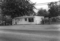
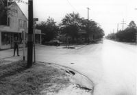
Johnny's (barber shop?), on site affected by the widening of State Road 13 (Remount Road). Surveyor notations on back of photo: "Dkt.: 10.562. Property owner: Fannie Lou Owens. Tract: 32. Date: Jul. 12, 1967." [See collection description for explanation of surveyor notations.]
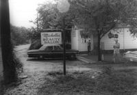
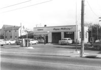
Michelle's Beauty Salon, on site affected by the widening of State Road 13 (Remount Road). Surveyor notations on back of photo: "Dkt.: 10.562. Property owner: Jerry Gray. Tract: 120. Date: Jul. 19, 1967." [See collection description for explanation of surveyor notations.]
Lafayette Motors (rear view), on site affected by the construction of Interstate 26 (I-26). Address: 680 King Street. Surveyor notations on back of photo: "Dkt.: 10.517. Property owner: Raymond A. Wittschen. Tract: 122. Station: 28+35 Lt. Southbound Lane Route 17. Date: March 5, 1963. Proximity." [See collection description for explanation of surveyor notations.]
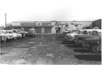
Lafayette Motors Service Dept., on site affected by the construction of Interstate 26 (I-26). Address: 680 King Street. Surveyor notations on back of photo: "Dkt.: 10.517. Property owner: Raymond A. Wittschen. Tract: 122. Station: 29±00 Lt. Southbound Lane Route 17. Date: March 5, 1963. Proximity." [See collection description for explanation of surveyor notations.]
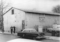
Building with gas pump (side view) on site affected by the construction of the Crosstown. Address: 134 Line Street. Surveyor notations on back of photo: "Dkt.: 10.524. Property owner: City of Charleston. Tract: 128. Station: 91+15 Rt. Date: Dec. 2, 1964. Partially in R/W." [See collection description for explanation of surveyor notations.]
Building with gas pump on site affected by the construction of the Crosstown. Address: 134 Line Street. Surveyor notations on back of photo: "Dkt.: 10.524. Property owner: City of Charleston. Tract: 128. Station: 91+15 Rt. Date: Dec. 2, 1964. Partially in R/W." [See collection description for explanation of surveyor notations.]
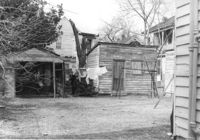
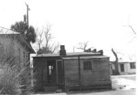
Sheds(?) and backyard of house, on site affected by the construction of Interstate 26 (I-26). Address: 94 Sheppard Street. Surveyor notations on back of photo: "Dkt.: 10.517. Property owner: Alice Davis. Tract: 101. Station: 23±55 Rt. Southbound Lane Route 17. Date: March 5, 1963. In R/W - Bought." [See collection description for explanation of surveyor notations.]
Renken Boat Co, on site affected by the widening of Route 171 (Folly Road). Surveyor notations on back of photo: "Dkt.: 10.494. Property owner: Renken Finance Co. Tract: 19. Station: 157+00 Lt. Date: Mar. 21, 1962. Proximity. [See collection description for explanation of surveyor notations.]
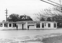
Furniture Repair Shop, on site affected by the widening of Route 171 (Folly Road). Surveyor notations on back of photo: "Dkt.: 10.494. Property owner: Isadora Bischoff. Tract: 32. Station: 162+00 Lt. Date: Mar. 21, 1962. Owner to cut off at R/W. [See collection description for explanation of surveyor notations.]
Ray Waits Mechanic/Body Shop on site affected by the construction of Interstate 26 (I-26). Address: 11 Walnut Street. Surveyor notations on back of photo: "Dkt.: 10.517. Property owner: Roy Waites [sic] Motors, Inc. Tract: 45. Station: 5950+55 Lt. - Line 6. Date: February 21, 1963." [See collection description for explanation of surveyor notations.]
Building (former bar, with Miller High Life signs on windows), on site affected by the widening of State Road 13 (Remount Road). Surveyor notations on back of photo: "Dkt.: 10.562. Property owner: Fannie Lou Owens. Tract: 32. Date: Jul. 12, 1967." [See collection description for explanation of surveyor notations.]
Gulf gas Station [Berkeley Gulf Service], on site affected by the widening of State Road 13 (Remount Road). Berkeley Drugs (Walgreens) in background. Surveyor notations on back of photo: "Dkt.: 10.562. Property owner: C.D. Hoffecker Estate. Tract: 24. Date: Jul. 12, 1967." [See collection description for explanation of surveyor notations.]
Gulf gas Station [Berkeley Gulf Service], on site affected by the widening of State Road 13 (Remount Road). Surveyor notations on back of photo: "Dkt.: 10.562. Property owner: C.D. Hoffecker Estate. Tract: 24. Date: Jul. 12, 1967." [See collection description for explanation of surveyor notations.]
Building on site affected by the widening of U.S. Route 17. Appears to have previously been a store. Presumably located in Mount Pleasant or vicinity. Surveyor notations on back of photo: "Dkt.: 10.597. Property owner: Geo. G. Browder, Jr. Tract: 22. Station: 275+20 Lt. Date: Sept. 17, 1968." [See collection description for explanation of surveyor notations.]
Buildings on site affected by the widening of U.S. Route 17. Wagon Wheel Furniture in foreground. Presumably located in Mount Pleasant or vicinity. Surveyor notations on back of photo: "Dkt.: 10.597. Property owner: Erma B. Salvo. Tract: 18. Station: 268± Lt. Date: Sept. 17, 1968." [See collection description for explanation of surveyor notations.]
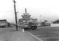
View on Spring Street from the Hardee's parking lot, on site affected by the construction of the Crosstown. Address: 223 Spring Street. Sea Food Dining Room in background, and signage for Hardee's and Everett's Hotel and Patio [restaurant?]. Surveyor notations on back of photo: "Dkt.: 10.524. Property owner: Sarah Chinnis Sanders. Tract: 157. Station: 13+75 Rt. Spring Street. Date: Dec. 2, 1964." [See collection description for explanation of surveyor notations.]
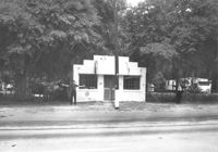
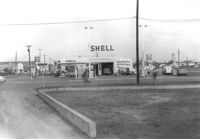
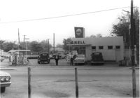
Shell gas station, on site affected by the construction of the Crosstown. Address: 233 Spring Street. View of street corner. Surveyor notations on back of photo: "Dkt.: 10.524. Property owner: Shell Oil Co. Tract: 155. Station: 9+00 Rt. Spring Street. Date: Dec. 2, 1965. Panoramic view." [See collection description for explanation of surveyor notations.]
Gulf gas Station [Berkeley Gulf Service], on site affected by the widening of State Road 13 (Remount Road), with directional signs for Yeaman's Hall and Hanahan Baptist Church. Surveyor notations on back of photo: "Dkt.: 10.562. Property owner: C.D. Hoffecker Estate. Tract: 24. Date: Jul. 12, 1967." [See collection description for explanation of surveyor notations.]
Kayo gas station, on site affected by the widening of State Road 13 (Remount Road). Surveyor notations on back of photo: "Dkt.: 10.562. Property owner: S.R. Hill - K.O. Station. Tract: 66. Date: Jul. 19, 1967." [See collection description for explanation of surveyor notations.]
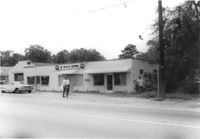
Bowers Hardware, on site affected by the widening of State Road 13 (Remount Road). Surveyor notations on back of photo: "Dkt.: 10.562. Property owner: J.R. Herrin. Tract: 82. Date: Jul. 19, 1967." [See collection description for explanation of surveyor notations.]
Building (rear view), perhaps once used commercially (market?), on site affected by the construction of Interstate 26 (I-26). Side facade has stepped parapet. [Building address number 2212(?).] Surveyor notations on back of photo: "Dkt.: 10.490. Property owner: F.F. Bellinger. Tract: 88. Station: 5825+40 Rt. Date: March 22, 1962. In R/W - Bought." [See collection description for explanation of surveyor notations.]
Lafayette Motors, on site affected by the construction of Interstate 26 (I-26). Address: 680 King Street. Surveyor notations on back of photo: "Dkt.: 10.517. Property owner: Raymond A. Wittschen. Tract: 122. Station: 28+35 Lt. Southbound Lane Route 17. Date: March 5, 1963. Proximity." [See collection description for explanation of surveyor notations.]
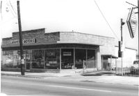
Lafayette Motors (Used Cars), on site affected by the construction of Interstate 26 (I-26). Address: 683 King Street. View of street corner (King Street and Fishburne Street. Surveyor notations on back of photo: "Dkt.: 10.517. Property owner: Hewitt Oil Co. Tract: 118. Station: 27+09 Lt. Southbound Lane Route 17. Date: March 5, 1963. Proximity." [See collection description for explanation of surveyor notations.]
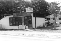
DuMont Television / Patterson's TV & Appliance Service Center / Karts Sales & Service on Dorchester Road, on site affected by the construction of Interstate 26 (I-26). Surveyor notations on back of photo: "Dkt.: 10.480. Property owner: Mrs. Margaret H. Patterson. Tract: 181. Station: 134+15 (Rt. (Route 642) [Dorchester Road]. Date: May 31, 1961. In R/W - Bought." [See collection description for explanation of surveyor notations.]
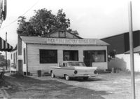
Pick & Pay Bicycle Repair Shop on site affected by the construction of Interstate 26 (I-26). Surveyor notations on back of photo: "Dkt.: 10.480. Property owner: G.S. Carter, Sr. Tract: 166. Station: 5681+50 Lt. Date: May 30, 1961. In R/W - Bought." [See collection description for explanation of surveyor notations.]
Health Club building and lot, on site affected by the construction of Interstate 26 (I-26). Nilson Storage Warehouse in background. Surveyor notations on back of photo: "Dkt.: 10.480. Property owner: G.S. Carter, Sr. Tract: 162. Station: 5677+60 Rt. Date: May 30, 1961. Damaged." [See collection description for explanation of surveyor notations.]
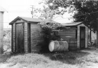
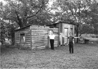
Sheds on site affected by the construction of Interstate 26 (I-26). Surveyor notations on back of photo: "Dkt.: 10.480. Property owner: Arlene Phillips, Est. Tract: 165. Station: 5681+10 Lt. Date: May 30, 1961. In R/W - Bought." [See collection description for explanation of surveyor notations.]
Esso (Humble) gas station (corner view) on site affected by the construction of the Crosstown. Address: 53 Lee Street (corner of Lee Street and Aiken Street). Surveyor notations on back of photo: "Dkt.: 10.518. Property owner: Humble Oil Refining Co. Tract: 51. Station: 46+65 Lt. N.B. lane Route 17. Date: Mar. 6, 1963. In R/W - Bought." [See collection description for explanation of surveyor notations.]
Esso (Humble) gas station on site affected by the construction of the Crosstown. Address: 53 Lee Street (corner of Lee Street and Aiken Street). Surveyor notations on back of photo: "Dkt.: 10.518. Property owner: Humble Oil Refining Co. Tract: 51. Station: 46+65 Lt. N.B. lane Route 17. Date: Mar. 6, 1963. In R/W - Bought." [See collection description for explanation of surveyor notations.]
Washington Grocery on site affected by the construction of Interstate 26 (I-26). Address: northeast corner of E Street and C Street. View of street corner. Surveyor notations on back of photo: "Dkt.: 10.517. Property owner: Isaac Washington. Tract: 27. Station: 5946+55 Lt. - Line 6. Date: February 21, 1963." [See collection description for explanation of surveyor notations.]
Gulf gas station on site affected by the construction of Interstate 26 (I-26). Surveyor notations on back of photo: "Dkt.: 10.471. Property owner: W.W. Holcombe. Tract: 109. Station: 5380+00 Lt. Date: Aug. 23, 1960. Proximity." [See collection description for explanation of surveyor notations.]
J&K Minute Market [893 Folly Road] and Sinclair gas station, on site affected by the widening of Route 171 (Folly Road). Surveyor notations on back of photo: "Dkt.: 10.494. Property owner: Otis R. Burbage. Tract: 40. Station: 176+40 Rt. Date: Mar. 21, 1962. Proximity. [See collection description for explanation of surveyor notations.]
Crown gas station, on site affected by the widening of State Road 13 (Remount Road). Possibly the corner of North Rhett Avenue and Remount Road. Surveyor notations on back of photo: "Dkt.: 10.562. Property owner: Corco Realty Co. (Crown). Tract: 142. Date: Jul. 19, 1967." [See collection description for explanation of surveyor notations.]
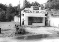
Little Italy pizza restaurant, next door to Remount Repair & Salvage, on site affected by the widening of State Road 13 (Remount Road). Surveyor notations on back of photo: "Dkt.: 10.562. Property owner: George Constantino. Tract: 116. Date: Jul. 19, 1967." [See collection description for explanation of surveyor notations.]
M&F Food Store on site affected by the construction of Interstate 26 (I-26). Address: 14 D Street. Surveyor notations on back of photo: "Dkt.: 10.517. Property owner: Frank Lea. Tract: 13. Station: 5944+55 Rt. - Line 6. Date: February 21, 1963. In R/W - Bought." [See collection description for explanation of surveyor notations.]
Building on site affected by the construction of Interstate 26 (I-26). Appears to previously have been a market; signage for Tru Ade (Drink) in window; gumball machines in front on sidewalk. Front facade has stepped parapet. Surveyor notations on back of photo: "Dkt.: 10.490. Property owner: Loretta Gillard [Loretta Gaillard]. Tract: 56. 5801+55 Lt. Line 'F'. Date: September 12, 1962. In R/W - Bought." [See collection description for explanation of surveyor notations.]
10-Mile News, on site affected by the widening of State Road 13 (Remount Road). Trailer park in background. Surveyor notations on back of photo: "Dkt.: 10.562. Property owner: Edna M. Tant. Tract: 5. Date: Jul. 12, 1967." [See collection description for explanation of surveyor notations.]
Push Grocery located at the southwest corner of Fishburne and St. Philip Streets, on site affected by the construction of Interstate 26 (I-26). Address: 77 Fishburne Street. Surveyor notations on back of photo: "Dkt.: 10.517. Property owner: Margaret J. Finn. Tract: 110. Station: 24+50 Lt. Southbound Lane Route 17. Date: March 5, 1963. In R/W - Bought." [See collection description for explanation of surveyor notations.]
The Twin Lanterns Antiques, Gifts, Used Furniture shop, on site affected by the widening of U.S. Route 17. Neighboring fireworks store in background. Presumably located in Mount Pleasant or vicinity. Surveyor notations on back of photo: "Dkt.: 10.597. Property owner: Oliver H. Smith. Tract: 56. Station: 297+70 Rt. Date: Sept. 17, 1968." [See collection description for explanation of surveyor notations.]
Buildings and lot on site affected by the construction of the Crosstown. Address: 620 King Street. Surveyor notations on back of photo: "Dkt.: 10.518. Property owner: News & Courier. Tract: 15. Station: 8+00 Lt. Line Street (Line #2) to 9+00 Lt. Date: Mar. 6, 1963. [Zero] Fence. [See collection description for explanation of surveyor notations.]
Gulf gas station, on site affected by the widening of State Road 13 (Remount Road). Arrow Restaurant and Trucker's Billiard Academy across the street. Surveyor notations on back of photo: "Dkt.: 10.562. Property owner: E.R. Gassman. Tract: 1. Date: Jul. 12, 1967." [See collection description for explanation of surveyor notations.]
Shell gas station, on site affected by the widening of State Road 13 (Remount Road). Arrow Restaurant in background. Surveyor notations on back of photo: "Dkt.: 10.562. Property owner: Shell Oil Co., Inc. Tract: 2. Date: Jul. 12, 1967." [See collection description for explanation of surveyor notations.]
H.W. Halter Cheese Butter Oleo Poultry Eggs [company], on site affected by the widening of Route 171 (Folly Road). Surveyor notations on back of photo: "Dkt.: 10.494. Property owner: H.W. Halter, et al. Tract: 78. Station: 209+20 Rt. Date: Mar. 21, 1962. Proximity. Loss of parking space. [See collection description for explanation of surveyor notations.]
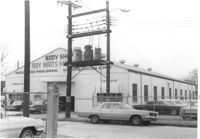
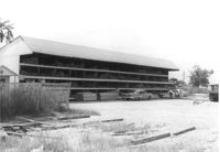
Charleston Plywood & Lumber Co. building (side view) on site affected by the construction of Interstate 26 (I-26). Surveyor notations on back of photo: "Dkt.: 10.490. Property owner: Kurco, Inc. Tract: 120, 121, 124 through 140-A and 133 through 133. Station: 5831+35 Rt. Date: August 29, 1962. Part in R/W to be moved by SCHD {SC Highway Department]." [See collection description for explanation of surveyor notations.]
Corner view (rear) of building that may have previously been a gas station, on site affected by the construction of Interstate 26 (I-26). Address: 669 King Street. Surveyor notations on back of photo: "Dkt.: 10.517. Property owner: The Texas Co. Tract: 83. Station: 27+40 Rt. Northbound Lane Route 17. Date: March 5, 1963. In R/W - Bought." [See collection description for explanation of surveyor notations.]
View of buildings in previous photos (Health Club, pizza restaurant, Nilson Storage Warehouse), on site affected by the construction of Interstate 26 (I-26). Surveyor notations on back of photo: "Dkt.: 10.480. Property owner: G.S. Carter, Sr. Tract: 162. Station: 5675+00 - 5679+75 Rt. & Lt. Date: May 30, 1961. View from across Route 642 [Dorchester Road]." [See collection description for explanation of surveyor notations.]
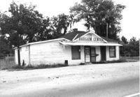
Bargain Center Supermarket on site affected by the widening of U.S. Route 17. Presumably located in southern Charleston County. Surveyor notations on back of photo: "Dkt.: 10.600. Property owner: Vernon A. Ellis. Tract: 3. Station: 512± - 514± Rt. Date: Sept. 18, 1968." [See collection description for explanation of surveyor notations.]
Sheds on site affected by the widening of U.S. Route 17. Presumably located in Mount Pleasant or vicinity. Surveyor notations on back of photo: "Dkt.: 10.597. Property owner: F. Gregorie, Estate. Tract: 93. Station: 460± Rt. Date: Sept. 17, 1968." [See collection description for explanation of surveyor notations.]
Ray Waits Mechanic/Body Shop (corner, one end of building, rear view) on site affected by the construction of Interstate 26 (I-26). Address: 11 Walnut Street. Surveyor notations on back of photo: "Dkt.: 10.517. Property owner: Roy Waites [sic] Motors, Inc. Tract: 45. Station: 5950±5950±67 Lt. Date: February 21, 1963." [See collection description for explanation of surveyor notations.]
Ray Waits Mechanic/Body Shop (rear view) on site affected by the construction of Interstate 26 (I-26). Address: 11 Walnut Street. Surveyor notations on back of photo: "Dkt.: 10.517. Property owner: Roy Waites [sic] Motors, Inc. Tract: 45. Station: 5950+60 Lt. - Line 6. Date: February 21, 1963." [See collection description for explanation of surveyor notations.]
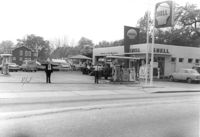
Shell gas station, on site affected by the construction of the Crosstown. Address: 233 Spring Street. Surveyor notations on back of photo: "Dkt.: 10.524. Property owner: Shell Oil Co. Tract: 155. Station: 9+20 Rt. Spring Street. Date: Dec. 2, 1965." [See collection description for explanation of surveyor notations.]
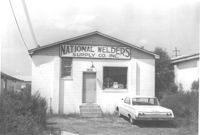
National Welders Supply Co. Inc. building, on site affected by the construction of Interstate 26 (I-26). Building address number 1858. Surveyor notations on back of photo: "Dkt.: 10.490. Property owner: Minnie R. Sherman. Tract: 115 and 118. Station: 5829+80 Lt. Date: August 29, 1962." [See collection description for explanation of surveyor notations.]
Grocery with signage for Dr. Pepper, Coca-Cola, Royal Crown Cola, Tru-Ade, Pepsi, on site affected by the construction of Interstate 26 (I-26). Neighboring house in background. Surveyor notations on back of photo: "Dkt.: 10.480. Property owner: John Chaplin. Tract: 18. Station: 5503+90 Rt. Date: May 2, 1961. In R/W - Bought." [See collection description for explanation of surveyor notations.]
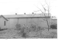
Sheds on site affected by the construction of Interstate 26 (I-26). Address: 1334 Rutledge Avenue. Surveyor notations on back of photo: "Dkt.: 10.490. Property owner: Heyward Barnes. Tract: 168. Station: 85' Rt. Sta. 5882+90. Date: May 15, 1962. In R/W - Bought." [See collection description for explanation of surveyor notations.]
Charleston Plywood & Lumber Co. building (side view) on site affected by the construction of Interstate 26 (I-26). Surveyor notations on back of photo: "Dkt.: 10.490. Property owner: Kurco, Inc. Tract: 120, 121, 124 through 140-A and 133 through 133. Station: 5832+30 Rt. Date: August 29, 1962." [See collection description for explanation of surveyor notations.]
Walker's Grocery and house (behind grocery) on site affected by the construction of Interstate 26 (I-26). Address: 17 Boyer Street. Surveyor notations on back of photo: "Dkt.: 10.503. Property owner: Addie Walker. Tract: 84. Station: 5914+60 Lt. Date: Feb. 20, 1963. In R/W - Bought." [See collection description for explanation of surveyor notations.]
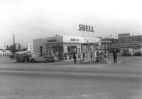
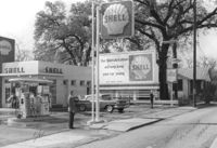
Shell gas station on site affected by the construction of Interstate 26 (I-26). Address: 1227 King Street. Surveyor notations on back of photo: "Dkt.: 10.503. Property owner: Shell Oil Co. Tract: 14-A. Station: 9+50 Rt. (Mt. Pleasant St.). Date: Apr. 20, 1965." [See collection description for explanation of surveyor notations.]
Shell gas station on site affected by the construction of Interstate 26 (I-26). Address: 1227 King Street. Surveyor notations on back of photo: "Dkt.: 10.503. Property owner: Shell Oil Co. Tract: 14-A. Station: 9+50 Rt. (Mt. Pleasant St.). Date: Apr. 20, 1965." [See collection description for explanation of surveyor notations.]
Shell gas station on site affected by the construction of Interstate 26 (I-26). Address: 1227 King Street. Surveyor notations on back of photo: "Dkt.: 10.503. Property owner: Shell Oil Co. Tract: 14-A. Station: 5893+80 Lt. Date: Feb. 19, 1963." [See collection description for explanation of surveyor notations.]
Charleston Plywood and Lumber Co. building (side view) on site affected by the construction of Interstate 26 (I-26). Surveyor notations on back of photo: "Dkt.: 10.490. Property owner: Minnie R. Sherman. Tract: 104-B. Station: 5829+20 Lt. Date: August 29, 1962. End to be moved by SCHD [SC Highway Department]." [See collection description for explanation of surveyor notations.]
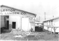
Charleston Plywood and Lumber Co. building, on site affected by the construction of Interstate 26 (I-26). Surveyor notations on back of photo: "Dkt.: 10.490. Property owner: Minnie R. Sherman. Tract: 104-B. Station: 5829+20 Lt. Date: August 29, 1962. End to be moved by SCHD [SC Highway Department]." [See collection description for explanation of surveyor notations.]