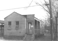
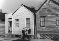
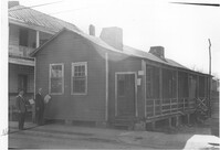
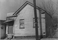
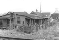
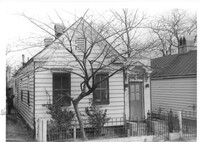
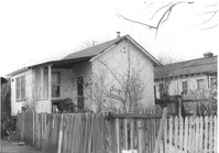
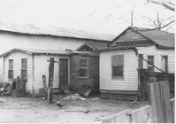
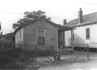
House (freedman's cottage?) on site affected by the construction of Interstate 26 (I-26). Address: 10 Brigade Street. Surveyor notations on back of photo: "Dkt.: 10.503. Property owner: Nathan Williams. Tract: 43. Station: 5905+30 Rt. Date: Feb. 19, 1963. In R/W - Bought." [See collection description for explanation of surveyor notations.]
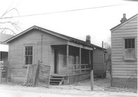
House (freedman's cottage) on site affected by the construction of Interstate 26 (I-26). Address: 9 Brigade Street. Surveyor notations on back of photo: "Dkt.: 10.503. Property owner: Gussie Feldman, et al. Tract: 44. Station: 5905+30 Rt. Date: Feb. 19, 1963. In R/W - Bought." [See collection description for explanation of surveyor notations.]
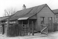
House (freedman's cottage) on site affected by the construction of Interstate 26 (I-26). Address: 8 Brigade Street. Surveyor notations on back of photo: "Dkt.: 10.503. Property owner: Gussie Feldman, et al. Tract: 44-A. Station: 5905+00 Rt. & Lt. Date: Feb. 19, 1963. In R/W - Bought." [See collection description for explanation of surveyor notations.]
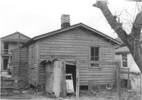
House (freedman's cottage) (rear view) on site affected by the construction of Interstate 26 (I-26). Address: 8 Brigade Street. Surveyor notations on back of photo: "Dkt.: 10.503. Property owner: Gussie Feldman, et al. Tract: 44-A. Station: 5905+00 Rt. & Lt. Date: Feb. 19, 1963. In R/W - Bought." [See collection description for explanation of surveyor notations.]
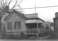
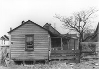
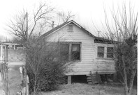
House (freedman's cottage) on site affected by the construction of Interstate 26 (I-26). Address: 7 Brigade Street. Surveyor notations on back of photo: "Dkt.: 10.503. Property owner: Idella C. Calvin. Tract: 45. Station: 5905+20 Lt. Date: Feb. 19, 1963. In R/W - Bought." [See collection description for explanation of surveyor notations.]
Houses (freedman's cottages) on site affected by the construction of Interstate 26 (I-26). Address: 12-14 Riker Street. Surveyor notations on back of photo: "Dkt.: 10.503. Property owner: Jesse Williams. Tract: 62. Station: 5910+40 Lt. Date: Feb. 20, 1963. In R/W - Bought." [See collection description for explanation of surveyor notations.]
Houses (freedman's cottages) (rear view) on site affected by the construction of Interstate 26 (I-26). Address: 12-14 Riker Street. Surveyor notations on back of photo: "Dkt.: 10.503. Property owner: Jesse Williams. Tract: 62. Station: 5910+40 Lt. Date: Feb. 20, 1963. In R/W - Bought." [See collection description for explanation of surveyor notations.]
House (freedman's cottage) (rear view) on site affected by the construction of Interstate 26 (I-26). Address: 16 Riker Street. Surveyor notations on back of photo: "Dkt.: 10.503. Property owner: Mary M. Polite, Est. Tract: 63. Station: 5910+50 Lt. Date: Feb. 20, 1963. In R/W - Bought." [See collection description for explanation of surveyor notations.]
House (freedman's cottage) on site affected by the construction of Interstate 26 (I-26). Address: 16 Riker Street. Surveyor notations on back of photo: "Dkt.: 10.503. Property owner: Mary M. Polite, Est. Tract: 63. Station: 5910+50 Lt. Date: Feb. 20, 1963. In R/W - Bought." [See collection description for explanation of surveyor notations.]
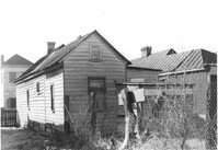
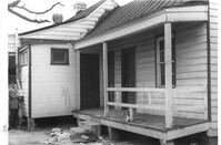
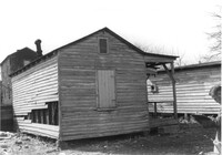
House (freedman's cottage) (rear view) on site affected by the construction of Interstate 26 (I-26). Address: 18 Riker Street. Fence and outbuilding in foreground. Surveyor notations on back of photo: "Dkt.: 10.503. Property owner: Mary Bradford, Est. Tract: 64. Station: 5910+40 Rt. & Lt. CL. Date: Feb. 20, 1963. In R/W - Bought." [See collection description for explanation of surveyor notations.]
House (freedman's cottage) on site affected by the construction of Interstate 26 (I-26). Address: 18 Riker Street. Surveyor notations on back of photo: "Dkt.: 10.503. Property owner: Mary Bradford, Est. Tract: 64. Station: 5910+40 Rt. & Lt. CL. Date: Feb. 20, 1963. In R/W - Bought." [See collection description for explanation of surveyor notations.]
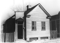
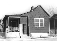
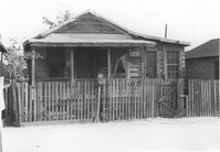
House (freedman's cottage) on site affected by the construction of Interstate 26 (I-26). Address: 24 Riker Street. Surveyor notations on back of photo: "Dkt.: 10.503. Property owner: Ethel Middleton. Tract: 65. Station: 5910+55 Rt. Date: Feb. 20, 1963. In R/W - Bought." [See collection description for explanation of surveyor notations.]
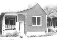
House (freedman's cottage) on site affected by the construction of Interstate 26 (I-26). Address: 24 Riker Street. Surveyor notations on back of photo: "Dkt.: 10.503. Property owner: Ethel Middleton. Tract: 65. Station: 5910+55 Rt. Date: Feb. 20, 1963. In R/W - Bought." [See collection description for explanation of surveyor notations.]
House (freedman's cottage) on site affected by the construction of Interstate 26 (I-26). Address: 24 Riker Street. Surveyor notations on back of photo: "Dkt.: 10.503. Property owner: Ethel Middleton. Tract: 65. Station: 5910+55 Rt. Date: May 30, 1963. In R/W - Bought." [See collection description for explanation of surveyor notations.]
House (freedman's cottage) (side view) on site affected by the construction of Interstate 26 (I-26). Address: 24 Riker Street. Surveyor notations on back of photo: "Dkt.: 10.503. Property owner: Ethel Middleton. Tract: 65. Station: 5910+55 Rt. Date: May 30, 1963. In R/W - Bought." [See collection description for explanation of surveyor notations.]
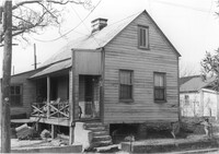
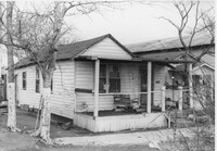
House (freedman's cottage) on site affected by the construction of Interstate 26 (I-26). Address: 13 Riker Street. Surveyor notations on back of photo: "Dkt.: 10.503. Property owner: Henry Yaschik. Tract: 71. Station: 5911+35 Lt. Date: Feb. 20, 1963. In R/W - Bought." [See collection description for explanation of surveyor notations.]
House (freedman's cottage) (rear view) on site affected by the construction of Interstate 26 (I-26). Address: 13 Riker Street. Surveyor notations on back of photo: "Dkt.: 10.503. Property owner: Henry Yaschik. Tract: 71. Station: 5911+35 Lt. Date: Feb. 20, 1963. In R/W - Bought." [See collection description for explanation of surveyor notations.]
House (freedman's cottage) on site affected by the construction of Interstate 26 (I-26). Address: 110 Russell Street. (1951 Sanborn map indicates the address is 157A Russell Street [157 Russell Street].) Surveyor notations on back of photo: "Dkt.: 10.503. Property owner: Arline Williams. Tract: 83. Station: 5915+00 Rt. Date: Feb. 20, 1963. In R/W - Bought." [See collection description for explanation of surveyor notations.]
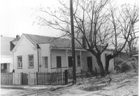
House (freedman's cottage) on site affected by the construction of Interstate 26 (I-26). Address: 102 Romney Street. Surveyor notations on back of photo: "Dkt.: 10.503. Property owner: Mary G. Dawson. Tract: 86. Station: 5915+60 Lt. Date: Feb. 20, 1963. In R/W - Bought." [See collection description for explanation of surveyor notations.]
House (freedman's cottage) on site affected by the construction of Interstate 26 (I-26). Address: 26 Addison Street. Surveyor notations on back of photo: "Dkt.: 10.503. Property owner: Alice Campbell Johnson. Tract: 96. Station: 5919+00 Rt. Date: Feb. 20, 1963. In R/W - Bought." [See collection description for explanation of surveyor notations.]
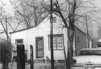
House (freedman's cottage) on site affected by the construction of Interstate 26 (I-26). Address: 21 Addison Street. Surveyor notations on back of photo: "Dkt.: 10.503. Property owner: Andrew R. Bland. Tract: 97. Station: 5919+90 Rt. Date: Feb. 20, 1963. In R/W - Bought." [See collection description for explanation of surveyor notations.]
House (freedman's cottage?) (rear view) on site affected by the construction of Interstate 26 (I-26). Address: 21 Addison Street. Surveyor notations on back of photo: "Dkt.: 10.503. Property owner: Andrew R. Bland. Tract: 97. Station: 5919+90 Rt. Date: Feb. 20, 1963. In R/W - Bought." [See collection description for explanation of surveyor notations.]
House (freedman's cottage) on site affected by the construction of Interstate 26 (I-26). Address: 15½ Addison Street [15 Addison Street]. Surveyor notations on back of photo: "Dkt.: 10.503. Property owner: Evan Gethers, et al. Tract: 100. Station: 5919+80 Lt. Date: Feb. 20, 1963. In R/W - Bought." [See collection description for explanation of surveyor notations.]
House (freedman's cottage) (rear view) on site affected by the construction of Interstate 26 (I-26). Address: 23 D Street. Surveyor notations on back of photo: "Dkt.: 10.517. Property owner: Maggie Tobias. Tract: 4. Station: 5945+65 Rt. on CL. Date: February 21, 1963. In R/W - Bought." [See collection description for explanation of surveyor notations.]
House (freedman's cottage) on site affected by the construction of Interstate 26 (I-26). Address: 23 D Street. Surveyor notations on back of photo: "Dkt.: 10.517. Property owner: Maggie Tobias. Tract: 4. Station: 5945+65 Rt. on CL. Date: February 21, 1963. In R/W - Bought." [See collection description for explanation of surveyor notations.]
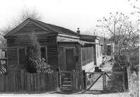
House (freedman's cottage?) (rear view) on site affected by the construction of Interstate 26 (I-26). Address: 15½ D Street. Surveyor notations on back of photo: "Dkt.: 10.517. Property owner: Rebecca Finkelstein. Tract: 12. Station: 5945+00 CL - Line 1. Date: February 21, 1963. In R/W - Bought." [See collection description for explanation of surveyor notations.]
House (freedman's cottage) on site affected by the construction of Interstate 26 (I-26). Address: 15 D Street. Surveyor notations on back of photo: "Dkt.: 10.517. Property owner: Rebecca Finkelstein. Tract: 12. Station: 5945+00 CL - Line 1. Date: February 21, 1963. In R/W - Bought." [See collection description for explanation of surveyor notations.]
House (freedman's cottage) on site affected by the construction of Interstate 26 (I-26). Address: 20 C Street. (1951 Sanborn map indicates the address is 14 C Street.) Surveyor notations on back of photo: "Dkt.: 10.517. Property owner: Edward Gallashaw, et al. Tract: 31. Station: 5948+50 Lt. - Line 6. Date: February 21, 1963. In R/W - Bought." [See collection description for explanation of surveyor notations.]
House (freedman's cottage) (rear view) on site affected by the construction of Interstate 26 (I-26). Address: 20 C Street. (1951 Sanborn map indicates the address is 14 C Street.) Surveyor notations on back of photo: "Dkt.: 10.517. Property owner: Edward Gallashaw, et al. Tract: 31. Station: 5948+50 Lt. - Line 6. Date: February 21, 1963. In R/W - Bought." [See collection description for explanation of surveyor notations.]
House (freedman's cottage) (rear view) on site affected by the construction of Interstate 26 (I-26). Address: 18 C Street. (1951 Sanborn map indicates the address is 16 C Street.) Surveyor notations on back of photo: "Dkt.: 10.517. Property owner: Virgil German, et al. Tract: 32. Station: 5948+80 Lt. - Line 6. Date: February 21, 1963. In R/W - Bought." [See collection description for explanation of surveyor notations.]
House (freedman's cottage) on site affected by the construction of Interstate 26 (I-26). Address: 18 C Street. (1951 Sanborn map indicates the address is 16 C Street.) Surveyor notations on back of photo: "Dkt.: 10.517. Property owner: Virgil German, et al. Tract: 32. Station: 5948+80 Lt. - Line 6. Date: February 21, 1963. In R/W - Bought." [See collection description for explanation of surveyor notations.]
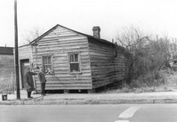
House (freedman's cottage?) on site affected by the construction of Interstate 26 (I-26). Address: 7 C Street. Surveyor notations on back of photo: "Dkt.: 10.517. Property owner: Cora G. Kelly, Est. Tract: 41. Station: 5950+00 Lt. Line 2. Date: February 21, 1963. In R/W - Bought." [See collection description for explanation of surveyor notations.]
House (freedman's cottage?) (rear view) on site affected by the construction of Interstate 26 (I-26). Address: 7 C Street. Surveyor notations on back of photo: "Dkt.: 10.517. Property owner: Cora G. Kelly, Est. Tract: 41. Station: 5950+00 Lt. Line 2. Date: February 21, 1963. In R/W - Bought." [See collection description for explanation of surveyor notations.]
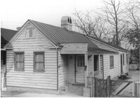
House (freedman's cottage) on site affected by the construction of Interstate 26 (I-26). Address: 146 Cooper Street. (1951 Sanborn map indicates the address is 94-92A Cooper Street.) Surveyor notations on back of photo: "Dkt.: 10.517. Property owner: Felix J. McKnight, et al. Tract: 65. Station: 5957+85 Lt. - Line 4. Date: March 5, 1963. All in R/W." [See collection description for explanation of surveyor notations.]
House (freedman's cottage) on site affected by the construction of Interstate 26 (I-26). Address: 146 Cooper Street. (1951 Sanborn map indicates the address is 94-92A Cooper Street.) Surveyor notations on back of photo: "Dkt.: 10.517. Property owner: Felix J. McKnight, et al. Tract: 65. Station: 5957+85 Lt. - Line 4. Date: March 5, 1963. All in R/W." [See collection description for explanation of surveyor notations.]
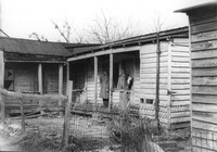
House (freedman's cottage) and neighboring structures (rear view) on site affected by the construction of Interstate 26 (I-26). Address: 146 Cooper Street. (1951 Sanborn map indicates the address is 94-92A Cooper Street.) Surveyor notations on back of photo: "Dkt.: 10.517. Property owner: Felix J. McKnight, et al. Tract: 65. Station: 5957+85 Lt. - Line 4. Date: March 5, 1963. All in R/W." [See collection description for explanation of surveyor notations.]
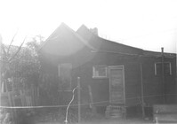
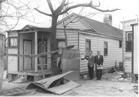
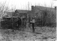
House (freedman's cottage) in dilapidated condition on site affected by the construction of Interstate 26 (I-26). Surveyor notations on back of photo: "Dkt.: 10.490. Property owner: Anna Conda, Ltd. Tract: 36. Station: 5796+55 Rt. Line 'A'. Date: September 11, 1962. In R/W - Bought." [See collection description for explanation of surveyor notations.]
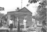
House (freedman's cottage) on site affected by the construction of Interstate 26 (I-26). Building address number 2003(?). Surveyor notations on back of photo: "Dkt.: 10.490. Property owner: L. Bradley. Tract: 39. Station: 5797+70 on CL Line 'G'. Date: September 11, 1962. In R/W - Bought." [See collection description for explanation of surveyor notations.]
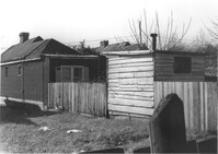
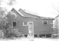
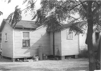
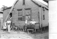
House (freedman's cottage) (rear view) on site affected by the construction of Interstate 26 (I-26). Surveyor notations on back of photo: "Dkt.: 10.490. Property owner: Janie Simmons. Tract: 41. Station: 5798+30 on CL Line 'G'. Date: September 12, 1962. In R/W - Bought." [See collection description for explanation of surveyor notations.]
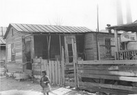
House (freedman's cottage) on site affected by the construction of Interstate 26 (I-26). Surveyor notations on back of photo: "Dkt.: 10.490. Property owner: Janie Simmons. Tract: 41. Station: 5798+30 on CL Line 'G'. Date: September 12, 1962. In R/W - Bought." [See collection description for explanation of surveyor notations.]
House (freedman's cottage) on site affected by the construction of Interstate 26 (I-26). Rear view of Photo 1140. Surveyor notations on back of photo: "Dkt.: 10.490. Property owner: Nathaniel Phoenix. Tract: 46. Station: 5799+65 Rt. Line 'G'. Date: September 11, 1962. Proximity." [See collection description for explanation of surveyor notations.]
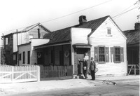
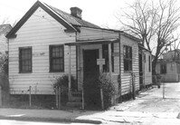
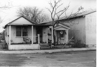
House (freedman's cottage) on site affected by the construction of the Crosstown. Address: 115 America Street. Surveyor notations on back of photo: "Dkt.: 10.518. Property owner: Jerusalem Baptist Church. Tract: 60. Station: 49+60 Rt. N.B. lane Route 17. Date: Mar. 7, 1963." [See collection description for explanation of surveyor notations.]
House (freedman's cottage) on site affected by the construction of the Crosstown. Address: 115 America Street. Surveyor notations on back of photo: "Dkt.: 10.518. Property owner: Jerusalem Baptist Church. Tract: 60. Station: 49+60 Rt. N.B. lane Route 17. Date: Mar. 7, 1963." [See collection description for explanation of surveyor notations.]
House (freedman's cottage) (rear view) on site affected by the construction of the Crosstown. Address: 115 America Street. Surveyor notations on back of photo: "Dkt.: 10.518. Property owner: Jerusalem Baptist Church. Tract: 60. Station: 49+10 Rt. N.B. lane Route 17. Date: Mar. 7, 1963." [See collection description for explanation of surveyor notations.]
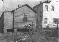
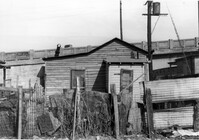
House (freedman's cottage) (rear view) on site affected by the construction of Interstate 26 (I-26). Surveyor notations on back of photo: "Dkt.: 10.490. Property owner: Ruth M. Bontz. Tract: 87-A. Station: 5824+80 Rt. Date: March 22, 1962. Proximity." [See collection description for explanation of surveyor notations.]
House (freedman's cottage) (rear view) on site affected by the construction of Interstate 26 (I-26). Surveyor notations on back of photo: "Dkt.: 10.490. Property owner: Martha Robinson, Est. Tract: 87-B. Station: 5825+00 Rt. Date: August 29, 1962. Proximity." [See collection description for explanation of surveyor notations.]
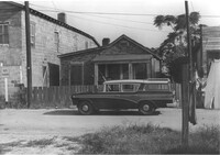
House (freedman's cottage) on site affected by the construction of the Crosstown. Address: 2 Lee Street. Industrial smokestacks in background (Cigar Factory?). Surveyor notations on back of photo: "Dkt.: 10.518. Property owner: Kate R. Rosen. Tract: 70. Station: 53+00 Lt. N.B. lane Route 17. Date: Mar. 7, 1963. In R/W - Bought." [See collection description for explanation of surveyor notations.]
House (freedman's cottage) (rear view) on site affected by the construction of the Crosstown. Address: 2 Lee Street. Elevated roadway (presumably the off-ramp of the Grace Memorial Bridge) in background. Surveyor notations on back of photo: "Dkt.: 10.518. Property owner: Kate R. Rosen. Tract: 70. Station: 53+00 Lt. N.B. lane Route 17. Date: Mar. 7, 1963. In R/W - Bought." [See collection description for explanation of surveyor notations.]
House (freedman's cottage) on site affected by the construction of the Crosstown. Address: 2 Lee Street. Industrial smokestacks in background (Cigar Factory?). Surveyor notations on back of photo: "Dkt.: 10.518. Property owner: Kate R. Rosen. Tract: 70. Station: 53+00 Rt. N.B. lane Route 17. Date: Mar. 7, 1963. In R/W - Bought." [See collection description for explanation of surveyor notations.]
House (freedman's cottage) (rear view) on site affected by the construction of the Crosstown. Address: 2 Lee Street. Surveyor notations on back of photo: "Dkt.: 10.518. Property owner: Kate R. Rosen. Tract: 70. Station: 53+00 Rt. N.B. lane Route 17. Date: Mar. 7, 1963. In R/W - Bought." [See collection description for explanation of surveyor notations.]