Caption: 'Cook's Earthquake Views of Charleston and Vicinity. Taken after the 31st of August, 1886. No.60, J.M. Wilson, Meeting St.' Charleston city directory for 1886 shows James M. Wilson at 39 Meeting Street.
Caption: 'Cook's Earthquake Views of Charleston and Vicinity. Taken after the 31st of August, 1886. No.70, E.B. Hume, Legare Street.' Charleston city directory for 1886 shows Errington B. Hume at 17 Legare Street.
Charleston Earthquake scene. Labeled 'Old Hospital' in lower left corner, with 'Trapman Street' handwritten at bottom, front. Additional note on reverse: 'See Cook No.189 [from Series 2, which is captioned as 'Ruins of Colored hospital.']
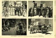
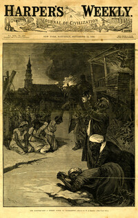
Caption: 'After The Earthquake At Charleston.--drawn by W.A. Rogers and W.P. Snyder from sketches by Frederic Remington and A.J. Gustin.--[see page 610.]' Individual captions: (top left): 'Open air preaching.' (top right): Subsistence committee.' (bottom left): 'Negro prayer-meeting.' (bottom right): 'Relief committee.' [full date September 18, 1886.]
Caption: 'Cook's Earthquake Views of Charleston and Vicinity. Taken after the 31st of August, 1886. No.21, Broad Street, south side.' Sign on building, at right, reads: 'Cigars & Tobacco' and 'W.W. Smith, 27.' Charleston city directory for 1886 lists William M. Smith, seal, stencil and stamp works, at 29 Broad Street.
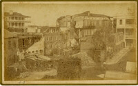
Caption: 'Cook's Earthquake Views of Charleston and Vicinity. Taken after the 31st of August, 1886. No.25, Vendue Range.' Written on front, at bottom: 'Charleston Earthquake scene - Vendue Range, foot of Queen St. near the wharf.' Sign for John Werner visible. Charleston city directory for 1886 shows business at 27 Vendue Range.
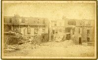
Caption: 'Cook's Earthquake Views of Charleston and Vicinity. Series No.2. No.154, East Bay, 60 days after the earthquake.' Written on front, at bottom: 'View on East Bay 60 days after the Earthquake.' Sign on building reads: 'Otto Tiedman & Sons.' Charleston city directory for 1886 shows business at 172-174 East Bay.
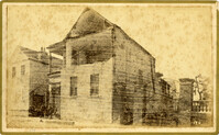
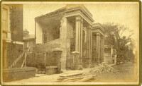
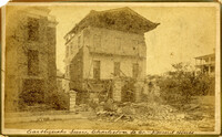
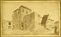
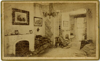
Caption: 'Cook's Earthquake Views of Charleston and Vicinity. Taken after the 31st of August, 1886. No.59, Pringle Smith, Meeting Street.' Written on front, at bottom: 'Earthquake scene Charleston, So.Ca.'
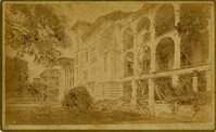
Caption: 'Cook's Earthquake Views of Charleston and Vicinity. Taken after the 31st of August, 1886. No.114, residence Col. Inglesby.' Charleston city directory for 1886 shows Charles Inglesby at 20 Meeting Street.
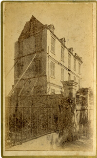
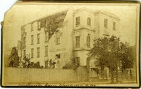
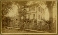
Caption: 'Cook's Earthquake Views of Charleston and Vicinity. Taken after the 31st of August, 1886. No.62, Wm. [William] Ravenel, East Battery, front.' Written on front, at bottom: 'Earthquake scene, Charleston, So.Ca. - Ravenel House'
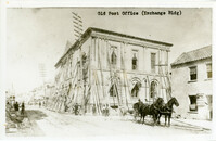
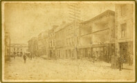
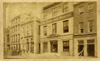
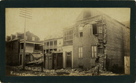
Charleston Earthquake scene. Written on front, at bottom: 'Broad St.' Image shows The News and Courier. Charleston city directory for 1886 lists it at 19 Broad Street.
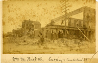
Charleston Earthquake scene. Written on front, at bottom: 'Wm M. Bird & Co. East Bay & Cumberland St.' Sign on building reads: '205, Wm. M. Bird & Co' and '203, Wm E. Holmes.'
Caption: 'Cook's Earthquake Views of Charleston and Vicinity. Taken after the 31st of August, 1886. [Marked as] No.16, First Presbyterian Church [and] No.99, Rear of Scotch Church.' Handwritten at bottom, front: 'Charleston Earthquake scene - First Presbyterian Church - side and rear view.'
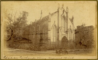
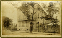
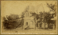
Caption: 'Cook's Earthquake Views of Charleston and Vicinity. Taken after the 31st of August, 1886. No.117, Citadel Square Baptist Church.' Also, handwritten at bottom, front: 'Charleston Earthquake scene - Citadel Square Baptist Church.'
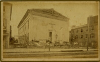
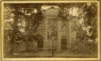
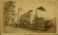
Caption: 'Cook's Earthquake Views of Charleston and Vicinity. Taken after the 31st of August, 1886. No.4, Roper Hospital.' Shows Roper Hospital when at Queen Street location.
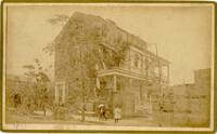
Caption: 'Cook's Earthquake Views of Charleston and Vicinity. Taken after the 31st of August, 1886. No.134, Dr. Frazer's, Tradd Street.' Charleston city directory for 1886 shows listing for Dr. Henry D. Fraser at 139 Tradd, with offices at 137 Tradd.
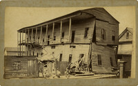
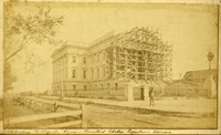
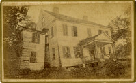
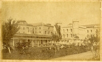
Caption: 'Charleston Earthquake. Photographs by Dr. E.P. Howland, taken on his visit to Charleston and the earthquake region of Ten Mile Hill and Summervile. Over 150 Photographs were taken. House of Mr. Ravenell [sic], President Northeastern R.R.'
Caption: 'Cook's Earthquake Views of Charleston and Vicinity. Taken after the 31st of August, 1886. No.78, Residence Wm. Johnson, Wentworth Street.' Charleston city directory for 1886 shows a William Johnson at 107 Wentworth Street.
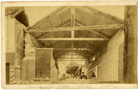
Charleston Earthquake scene. Written on front, at bottom: 'Commercial Cotton Press, East Bay.' Charleston city directory for 1886 lists Commercial Wharf and Cotton Press, Co. on East Bay Street and Longitude Lane.
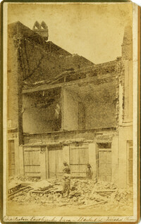
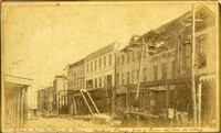
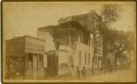
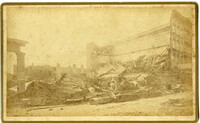
Caption: 'Cook's Earthquake Views of Charleston and Vicinity. Taken after the 31st of August, 1886. No.27, Hayne Street - ruins of three large buildings.' Sign on column at left reads: 'Charleston Bag Factory.' Charleston city directory for 1886 shows a bag factory at 15-19 Hayne Street.
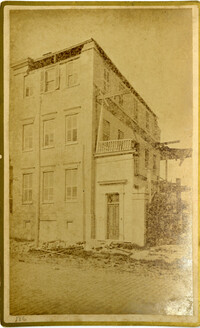
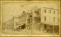
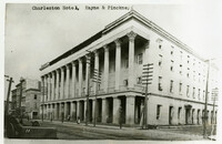
Charleston Earthquake scene. Possibly a copy of No.11 of Cook's Earthquake Views. Shows damage to the Charleston Hotel, demolished in 1960, which stood at 200 Meeting Street. 'Charleston Hotel, Hayne & Pinckney' is typewritten onto the image. Hayne and Pinckney Streets were two of the boundary streets that surrounded the hotel.
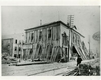
Charleston Earthquake scene. Sign at bottom of image: 'Mr. August Melm's room, 21 King Street.' Also, written on front, at bottom: 'Earthquake - Charleston S.C. 1886.' Charleston city directory for 1886 lists August Melm, a local attorney, as boarding at 21 King Street.