Plowden Weston's Plantation Journal is part of the Weston family papers collection. Plowden Weston came to the colony of South Carolina from Warwickshire, England in 1757, and he bought Laurel Hill Plantation and adjoining lands in 1775. This journal contains lists of items shipped to Waccamaw Plantations (Wandow, Laurel Hill, Holly Hill, Waccamaw) and accounts of crops (rice, cotton) transported and sold in various Lowcountry area wharves, 1802-1820. Items shipped to plantations include tools, textiles, seeds, sundries, medicines, etc. Journal includes other ephemera such as correspondences, bank deposits, financial accounts, formulas, instructions. Items distributed to enslaved people often appear with lists of their names.
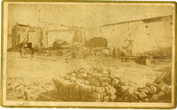
Caption: 'Cook's Earthquake Views of Charleston and Vicinity. Taken after the 31st of August, 1886. No.125, Scene near Atlantic Wharf.' Charleston city directory for 1886 lists Atlantic Wharf at the rear of the Post Office.
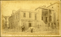
Caption: 'Cook's Earthquake Views of Charleston and Vicinity. Taken after the 31st of August, 1886. No.82, East Bay Street.' Sign for Jas [James] Ackermann at 114 East Bay is visible.
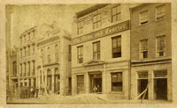
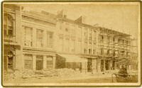
Caption: 'Cook's Earthquake Views of Charleston and Vicinity. Taken after the 31st of August, 1886. No.133, 5 and 7 Broad Street.' Written on front, at bottom: 'Walker, Evans & Cogswell, Broad St.' Charleston City Directory for 1886 shows Walker, Evans & Cogswell at 3-5 Broad Street. Etiwan[Phosphate] Company is at 7 Broad.
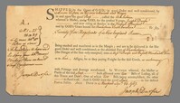
A bill of lading dated Sept 16, 1767 for twenty-five hogshead of New England rum imported by way of one Aaron Lopez and delivered to the Port of Charleston, SC for Durfee and Russell.
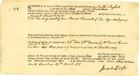
A bill of lading dated March 29, 1771 and signed by Joseph Durfee for a cargo of "two hogshead & four barrels Pimento & Ten logs Mahogany" sent by Nathaniel Russell from the sloop of Charleston bound for Newport, Rhode Island to be received by William and Samuel Vernon.
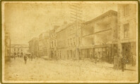
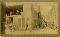
Caption: 'Cook's Earthquake Views of Charleston and Vicinity. Taken after the 31st of August, 1886. No.21, Broad Street, south side.' Sign on building, at right, reads: 'Cigars & Tobacco' and 'W.W. Smith, 27.' Charleston city directory for 1886 lists William M. Smith, seal, stencil and stamp works, at 29 Broad Street.
Caption: 'Cook's Earthquake Views of Charleston and Vicinity. Taken after the 31st of August, 1886. No.25, Vendue Range.' Written on front, at bottom: 'Charleston Earthquake scene - Vendue Range, foot of Queen St. near the wharf.' Sign for John Werner visible. Charleston city directory for 1886 shows business at 27 Vendue Range.
Caption: 'Cook's Earthquake Views of Charleston and Vicinity. Series No.2. No.154, East Bay, 60 days after the earthquake.' Written on front, at bottom: 'View on East Bay 60 days after the Earthquake.' Sign on building reads: 'Otto Tiedman & Sons.' Charleston city directory for 1886 shows business at 172-174 East Bay.
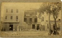
Charleston Earthquake scene. Written on front, at bottom: 'Broad St.' Image shows The News and Courier. Charleston city directory for 1886 lists it at 19 Broad Street.
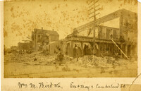
Charleston Earthquake scene. Written on front, at bottom: 'Wm M. Bird & Co. East Bay & Cumberland St.' Sign on building reads: '205, Wm. M. Bird & Co' and '203, Wm E. Holmes.'
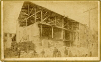
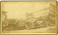
Charleston Earthquake scene. Written on front, at bottom: 'Commercial Cotton Press, East Bay.' Charleston city directory for 1886 lists Commercial Wharf and Cotton Press, Co. on East Bay Street and Longitude Lane.
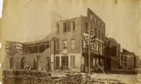
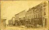
Caption: 'Cook's Earthquake Views of Charleston and Vicinity. Taken after the 31st of August, 1886. No.27, Hayne Street - ruins of three large buildings.' Sign on column at left reads: 'Charleston Bag Factory.' Charleston city directory for 1886 shows a bag factory at 15-19 Hayne Street.
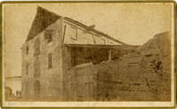
Caption: 'Cook's Earthquake Views of Charleston and Vicinity. Series No.2. No.159, Storehouses Adger's Wharf.' Charleston city directory for 1886 lists Adger's Wharf as opposite Tradd Street on East Bay.
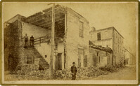
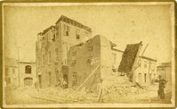
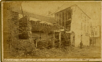
Charleston Earthquake scene. Possibly from Cook's Earthquake views, No.157, scene near Accomodation Wharf. Written on front, at bottom: 'Charleston Earthquake Scene - ruins on Accomodation Wharf.' Charleston city directory for 1886 lists Accomodation Wharf as opposite 176 East Bay Street.
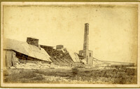
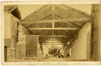
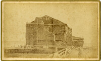
Caption: ' Cook's Earthquake Views of Charleston and Vicinity. Series No.2. No.164, Storehouse of Bennett's Mill.' Note on the catalog card show storehouse located at East end of Wentworth Street.
Charleston Earthquake scene. Possibly from Cook's Earthquake views, No.31, Tenement houses on East Bay. Written on front, at bottom: 'Charleston Earthquake scene - house on East Bay near Tradd.' Sign on building at left, reads: 'Ship & Family Groceries' known to be at the corner of East Bay and Queen. Sign on building at right, reads: '65' and possibly 'Sahlmann.' 1886 Charleston city directory lists L. Sahlmann, Hay & Grain, at 83 East Bay.
Caption: 'Cook's Earthquake Views of Charleston and Vicinity. Series No.2.' No.156, Scene near Brown's Wharf.' Charleston city directory for 1886 lists Brown's Wharf as opposite Vendue Range.
Caption: 'Cook's Earthquake Views of Charleston and Vicinity. Series No.2. No.190, Kerr's Wharf. Charleston city directory for 1886 lists Kerr's Wharf as opposite Cordes.
Caption: 'Cook's Earthqauke Views of Charleston and Vicinity. Taken after the 31st of August, 1886. No.126, East Bay, corner Queen Street.' Sign on building reads: 'Ship & Family Groceries.' Possibly J.J.W. Luden, retail grocers and ship chandlers, located 167-169 East Bay, according to the 1886 Charleston city directory.
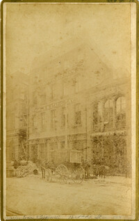
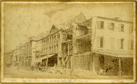
Caption: 'Cook's Earthquake Views of Charleston and Vicinity. Taken after the 31st of August, 1886. No.22, Broad Street, north side.' Charleston Insurance & Trust, Co. is shown to the left. Charleston city directory for 1886 lists it as Ravenel, Johnson & Co. at 12 Broad Street.
Charleston Earthquake scene. Written on front, at bottom: 'Charleston Earthquake scene - warehouse on Atlantic Wharf.' Charleston city directory for 1886 lists Atlantic Wharf at the rear of the Post Office.