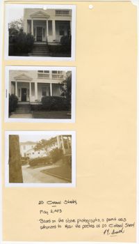
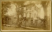
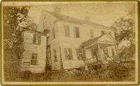
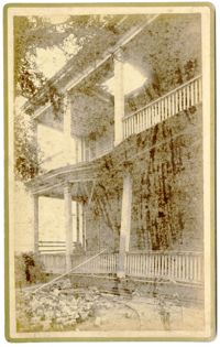
Three black and white photographs of No. 20 Colonial Street: Top (front facade/east elevation); Middle (front facade/east elevation); Bottom (front yard and sidewalk in front of structure). The photographs are stapled to a beige sheet of paper with two holes punched through the top. The paper is labeled "20 Colonial Street." There is a handwritten note on the paper explaining the purpose of the photographs. Their goal was to repair the porches at No. 20 Colonial Street. The note is signed by a "Smith." There is a white border surrounding all three photographs. The structure at No. 20 Colonial Street has a covered porch spanning the entirety of the exterior of the first story front facade/east elevation. There is a pediment held above the entryway of the porch by two Doric free standing columns. The first story is elevated with stairs leading up to the porch. There is a front yard covered in grass and an urban garden bordering the structure. There is a paved walkway to the entry stairs and a sidewalk running parallel to the street in front of the structure.
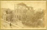
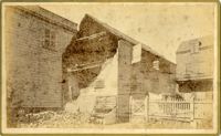
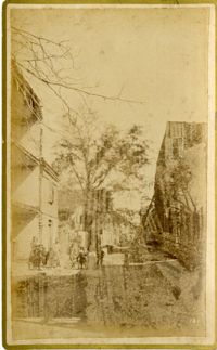
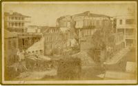
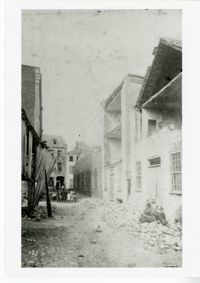
Caption: 'Cook's Earthquake Views of Charleston and Vicinity. Taken after the 31st of August, 1886. No.116, wreck in George Street.' Written on front, at bottom: 'Charleston Earthquake view - Ruins in George St.'
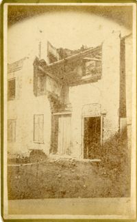
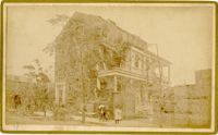
Written on reverse: 'House in which young Mr. Robson was killed. Two young ladies were buried in the ruins were rescued. Coming near Cannon.' Possibly from Cook's Earthquake Views, No.132, residence of J.N. Robson, from west. Written on front, at bottom: 'Charleston Earthquake view. Residence of Mr. J.N. Robson, whose eldest son was killed.' Charleston city directory for 1886 shows James N. Robson at 200 Coming Street.
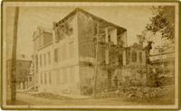
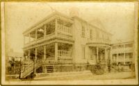
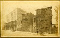
Charleston Earthquake scene. Possibly from Cook's Earthquake Views, no.63. William Ravenel, East Battery, rear. Written on front, at bottom: 'Wm Ravenel's, East Battery.'
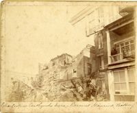
Caption: 'Cook's Earthquake Views of Charleston and Vicinity. Series No.2. No.181, Beresford Street.' This may be Beresford Alley which is also known as Clifford Street.
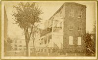
Caption: 'Cook's Earthquake Views of Charleston and Vicinity. Taken after the 31st of August, 1886. No.65, _____ Holmes, East Battery.' Written on front, at bottom: 'Charleston Earthquake scene - Holmes residence, East Battery.' Charleston city directory for 1886 shows Charles R. Holmes, Jr., at 19 East Battery.
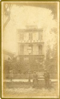
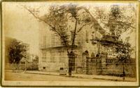
Caption: 'Cook's Earthquake Views of Charleston and Vicinity. Series No.2. No.170, Buist residence, Rutledge Street.' Written on front, at bottom: Buist Residence, 43 Rutledge St.' Charleston city directory for 1886 shows listing for Samuel S. Buist at 43 Rutledge Avenue.
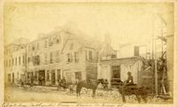
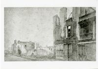
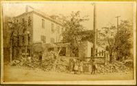
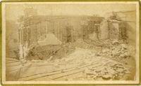
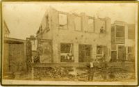
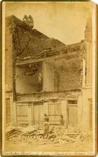
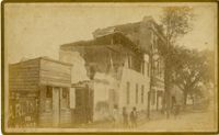
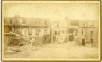
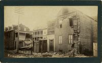
Caption: 'Cook's Earthquake Views of Charleston and Vicinity. Taken after the 31st of August, 1886. No.135, Corner State and Chalmers Streets.' Written on front, at bottom: 'Charleston Earthquake views - ruins cor[ner] Chalmers & State Str.'
Caption: 'Cook's Earthquake Views of Charleston and Vicinity. Series No.2. No.187, residence of Mr. A. Lengnick.' Charleston city directory for 1886 shows Albert Lengnick at 11 Pitt Street.
Caption: 'Cook's Earthquake Views of Charleston and Vicinity. Series No.2. No.167, rear of residence of Geo. [George] W. Williams, Jr.' Charleston city directory for 1886 shows George W. Williams, Jr. at 2 Atlantic Street.
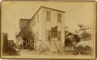
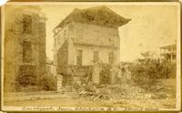
Caption: 'Cook's Earthquake Views of Charleston and Vicinity. Series No.2. No.182, Porch of Lazarus House.' Hassell Street. Charleston city directory for 1886 shows Mrs. B.D. Lazarus at 64 Hassell Street.
Caption: 'Cook's Earthquake Views of Charleston and Vicinity. Taken after the 31st of August, 1886. No.60, J.M. Wilson, Meeting St.' Charleston city directory for 1886 shows James M. Wilson at 39 Meeting Street.
Caption: 'Cook's Earthquake Views of Charleston and Vicinity. Taken after the 31st of August, 1886. No.70, E.B. Hume, Legare Street.' Charleston city directory for 1886 shows Errington B. Hume at 17 Legare Street.
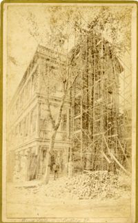
Caption: 'Cook's Earthquake Views of Charleston and Vicinity. Taken after the 31st of August, 1886. No.59, Pringle Smith, Meeting Street.' Written on front, at bottom: 'Earthquake scene Charleston, So.Ca.'
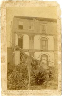
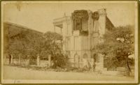
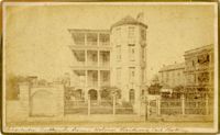
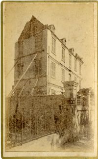
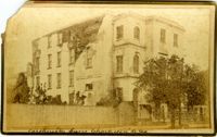
Caption: 'Cook's Earthquake Views of Charleston and Vicinity. Taken after the 31st of August, 1886. No.114, residence Col. Inglesby.' Charleston city directory for 1886 shows Charles Inglesby at 20 Meeting Street.
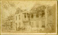
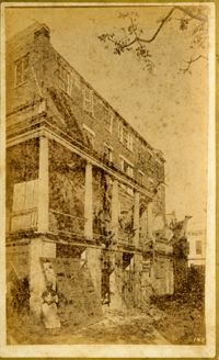
Caption: 'Cook's Earthquake Views of Charleston and Vicinity. Taken after the 31st of August, 1886. No.62, Wm. [William] Ravenel, East Battery, front.' Written on front, at bottom: 'Earthquake scene, Charleston, So.Ca. - Ravenel House'
Caption: 'Cook's Earthquake Views of Charleston and Vicinity. Taken after the 31st of August, 1886. No.134, Dr. Frazer's, Tradd Street.' Charleston city directory for 1886 shows listing for Dr. Henry D. Fraser at 139 Tradd, with offices at 137 Tradd.
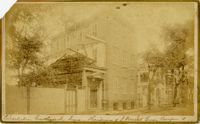
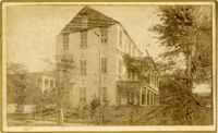
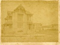
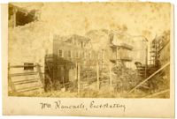
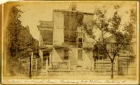
Caption: 'Charleston Earthquake. Photographs by Dr. E.P. Howland, taken on his visit to Charleston and the earthquake region of Ten Mile Hill and Summervile. Over 150 Photographs were taken. House of Mr. Ravenell [sic], President Northeastern R.R.'
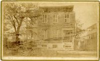
Caption: 'Cook's Earthquake Views of Charleston and Vicinity. Taken after the 31st of August, 1886. No.78, Residence Wm. Johnson, Wentworth Street.' Charleston city directory for 1886 shows a William Johnson at 107 Wentworth Street.