Elias Horry's 454 acre plot in the St. James parish near the Santee River, shows property boundaries, no details on the property or type of land. Names associated with this plat include Elias Horry, Daniel Horry and A. Bonneau.
Plat of 222 acres granted to and acquired by Elias Horry on the Santee River. Names associated with this plat are Elias Horry and Izard. Names associated with this plat are Elias Horry and Izard. Notable geographic locations are Santee River, Toby Creek, Wild Hook Creek.
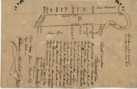
Copy of plat granted to John Atchison. "The plat annexed to the grant dated March 2, 1736." Names associated with this plat are John Atchison, James St. John, Thomas Broughton, J. Branch and Middleton. Notable geographic locations include Santee, Four Mile Creek, Santee River, and Cravens County [now in parts of Berkeley, Charleston, Georgetown, and Williamsburg counties].
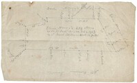
250 acre plot given to Peter Lesesne on the 20th of February 1760, butting and bounding on the south side of the Santee River. Names associated with this plat are Peter Lesesne, James Thomson, Peter Robert, Joseph Manap [?], and Phippes.
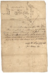
True copy of Peter Sinkler plat contains 310 acres in Craven County [now in parts of Berkeley, Charleston, Georgetown, and Williamsburg counties] bounding northwest on land of Isaac Porcher and Rene Pyre, southeast on land of Robert Taylor and Rene Ravenel, and northwest on Santee River. Names associated with this plat are Peter Sinkler, Robert Taylor, Ephraim Mitchell, Rene Pyre, Isaac Porcher, Rene Ravenel, John Brernon, and Henry Mowlon. Notable geographic locations include St. James Parish, the Santee River and Craven County.
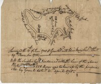
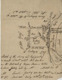
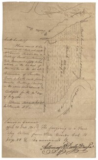
Plan of the land claimed by James Sinkler on Santee River and comprehended with the claim of White Oak Plantation belonging to Ralph Izard. Names associated with this plat are Ralph Izard, James Sinkler, Peter Sinkler, John Guerry, and Stephens.
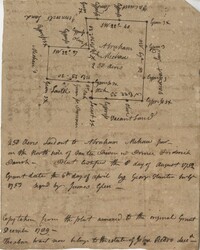
Copy of a plat granted to Abraham Michau north side of Santee and containing 213 acres in the Georgetown district in Craven County [now in parts of Berkeley, Charleston, Georgetown, and Williamsburg counties]. Names associated with this plat are Abraham Michau, James St. John, Thomas Broughton, Paul Michau, and John Dear.
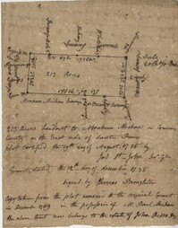
Copy of a plat of 250 acres laid out to Abraham Michau on the north side of Santee River and “now belonging to John Pedro." Names associated with this plat are Abraham Michau, John Pedro, George Hunter and James Glen. Notable geographic locations include the Santee River, Prince Frederick Parish and Georgetown District.
Copy of plat of 300 acres of land situated in Craven County on the north side of the Santee River bounding north east on Bennett's land and the other sides on vacant land. Names associated with this plat are Susannah Williams, Thomas Ferguson, Moses Bennett, and Benjamin [?]. Notable geographic locations include the Santee River, Craven County [now in parts of Berkeley, Charleston, Georgetown, and Williamsburg counties], and Georgetown.
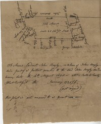
A 550 acre plot of land given to Francis Middleton, the entire plot is labeled as marsh located on the banks of the branches of the Santee River. Names associated with this plat are Francis Middleton, Ephraim Mitchell, Josh Purcell and A. Darby. Notable geographic locations included are St. James Parish.
Copy of two tracts of land A and B. A containing 1144 acres, and B, containing 580 located north of the Santee River and Duck Creek for Georgetown District. John Hutchinson, Chardon, Laroche, Foijsin, Gail Huger, Isaac Huger, Mark Hugin, Ford, Job. Rothmaklen, Jospeh Purcell and Charles Parker. Notable geographic locations include Mosquito Creek, Four Mile Creek, Belin Creek Duck Creek, Minim Creek, Santee River, Winyaw Bay, and Georgetown District.
200 acre plot of land located in Berkeley County budding and bounding on the NW with the Santee River and Russell's Creek, shows tree types and surrounding swamps. Names associated with this plat are Thomas Haile, William DeBrahms, John Evans and Thomas S. Jones.
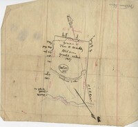
Plat of 1,136 acres granted to Thomas W. Markley. Plat includes the Santee River, a lake, and various trees on the property line. Names associated with this plat are Thomas Markly, R.P. Smith and David Owens. Notable geographic locations include Santee River and [Northrace] Lake.
Plat contains land on the Santee River; acreage unknown. No structures are included. Names associated with this plat are S.G. Staney, A.M. Rickenbacher, and Fred J. Smith. Notable geographic locations include the Santee River.
The Mouzon Plat Book surveys lands held by various individuals and families in Craven County [now in parts of Berkeley, Charleston, Georgetown, and Williamsburg counties], Colleton County and Berkeley County in South Carolina. Plats are drawn in pencil and ink. Book includes an index at the beginning and at the end are two pages of accounts and also lands to be resurveyed for the estate of Henry Mouzon Jr.
Letter from Royal Flint to Nathanael Greene. Includes a discussion of the discrepancies in the mail and missed communications. Flint goes on to discuss the political nature of the country as was told to him by General Greene. Flint continues to discuss the general nature of the politics and questioning the decisions made by the government; saying the people have developed a habit of complaining, the need to regulate the currency, and refrain from continuing to alter the constitution.He also addresses the issue of pay, advocating the compensation of the army. He then discusses the lack of supplies for General Greene's troops. Flint goes on to state that Colonel Wadsworth is tiring of his role in the legislature.
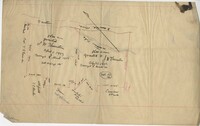
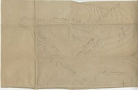
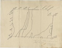
Sketch of land with no measurements or names, shows some trees and unnamed road/creeks. Names associated with this plat are John Michael and J.H. Alston. Notable geographic locations include Santee River and St. James Parish.