Louis Coste, Hal's third great-grandfather, arrived as a Huguenot immigrant from Montpelier, France, in the late 18th century and became a naturalized citizen in 1808. He and his wife, Lucinda Mackey, had three sons, among them Napoleon L. Coste, who went on to have a long and adventurous career in the U.S. Revenue Cutter Service. That included expeditions with naturalist James Audubon, and the placement of many of the lighthouses and other aids to navigation along the east coast. His most famous deed was at the outbreak of the Civil War when Coste commandeered the revenue cutter, William Aiken, and turned it over to the state of South Carolina. Hal recounts other significant events in the life of N.L. Coste, as well as his son, Napoleon Edward, who also served the Confederacy and later the Revenue Cutter Service. Hal next recounts his memories of his grandfather, Vincent O. Coste, who served in the U.S. Lifesaving Service, which joined with the Revenue Cutter Service in 1915 to form the U.S. Coast Guard. Vincent later commanded the Coast Guard station on Sullivan's Island. Hal next speaks of the lives of his mother and father, before detailing his own time on the island. These include his mayonnaise meal in kindergarten, his learning to swim in the creek behind the island, and especially his passion for surfing. Before ending with his general feelings regarding changes that have occurred on Sullivan's Island, Hal explains and displays the two silver life-saving medals from the Coast Guard that hang on his walls, one for Hal's own actions and one for the incredible story of his great-uncle, James Coste, who in 1898 saved a young man who would turn out to be the grandfather of Charleston's long time mayor, Joe Riley.
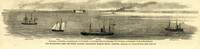
Caption: 'Our blockading fleet off North Channel, Charleston Harbor, South Carolina.--sketched by a Naval Officer.--[see page 79.] References--A. Fort Sumter.--B. Charleston City.--C. Fort Moultrie.--D. Rebel tug at work on the obstructions.--E. Obstructions.--F. Fort Johnson.--G. Mount Pleasant Batteries.' Also identified in image: South Carolina, Blunt, Daylight and Stars and Stripes (ships of the fleet). [full date January 31, 1863.]
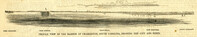
Caption: 'Profile view of the harbor of Charleston, South Carolina, showing the city and forts.' Identified in the image: Fort Johnston (sic), Fort Sumter, Charleston, Fort Moultrie and Mount Pleasant. [full date December 29, 1860.]
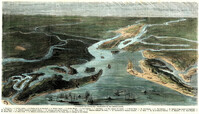
[Color image.] Caption (in French): 'Evenements des Etats-Unis: Charleston et ses fortifications. [Events of the United States: Charleston and its fortifications.] 1--Charleston. 2--Riviere Ashley [Ashley River]. 3--Chemin de fer de Savannah [Savannah Railway]. 4--Riviere Cooper [Cooper River]. 5--Riviere Wando [Wando River]. 6--Fort Pinkney [Castle Pinckney]. 7--Fort Ripley. 8--Fort Johnson (ile James) [James Island]. 9--Riviere Stone [Stono River]. 10--Fort Sumter. 11--Fort Moultrie. 12--Batterie Gregg (pointe de Gumming) [Battery Gregg (Cummings Point)]. 13--Fort Wagner. 14--Batteries rasantes du general Gilmore [grazed batteries of General Gilmore]. 15--Ouvrages pris par les federaux. [Works undertaken by the Federals]. 16--Phare Inlet [Lighthouse inlet]. 17--Batteries federales (ile Folly) [Federal Batteries (Folly Island)]. 18--Canonnieres et vaisseaux cuirasses [gunboats and ironclads]. 19--Hotel. 20--Ile et batteries Sullivan [Sullivan Island and Batteries]. 21--Moultrie. 22--Mont Pleasant [Mount Pleasant]. 23--Breach Inlet. 24--Shem Creek. 25--Batteries construite par les confederes sur l'ile James, dans le voisinage du fort Johnson [Batteries built by the Confederates on James Island, in the vicinity of Fort Johnson].