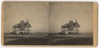
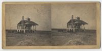
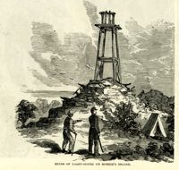
Stereoscopic image of the ruins of a house on the beach on Morris Island, SC with a group of men on and outside of the structure. Handwritten caption on the verso reads, "Beacon House on Morris Island. Jany 1864."
Caption: 'Morris Island, as seen from Fort Sumter.--[drawn by an Officer of Major Anderson's Command.]' Also identified with captions: 'Battery from which the "Star of the West" was fired upon. Cumming's Point. Sand Battery, connected by covered gallery with...iron-clad battery.' [full date March 2, 1861.]
Stereoscopic image of with soldiers, horses and carts inside Fort Gregg. The printed caption on the verso notes the image as "Interior Fort Gregg, Morris Island, S.C."
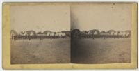
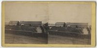
Stereoscopic image of a view from top of Fort Wagner with four men visible on the distant ridge. The image shows military tents, cannons, and cannonballs.
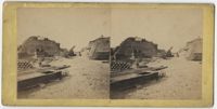
Stereoscopic image of soldiers along side a partially destroyed house. The print on the verso identifies the location as Morris Island, South Carolina.
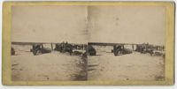
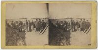
Stereoscopic image of soldiers in a trench with cannons. The print on the verso identifies the location as Mortar Battery on Morris Island, South Carolina.
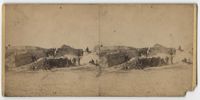
Stereoscopic image of interior battery wall with soldiers and cannon in the foreground. The printed caption on the verso reads, "Battery made of Sand Bags, Morris Island, S.C."
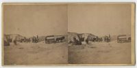
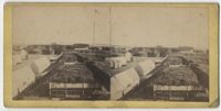
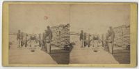
Stereoscopic image of military buildings with brick wall yards containing stacked cannonballs and other weapon supplies. A handwritten note on the verso captions the image, "Ordinance Yard, Morris Island, S.C."
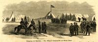
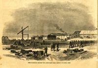
Caption in German: 'Belagerung von Charleston.--Gen. Gillmore's hauptquartier auf Morris Island.' [Siege of Charleston.--Gen. Gillmore's headquarters on Morris Island.]
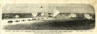
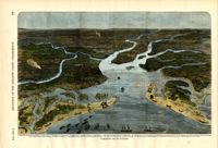
Caption: 'Panoramic view of Charleston Harbor--advance of iron-clads to the attack, April 7. Union--A. Keokuk. B. Nahunt. C. Nantucket. D. Catskill. E. Ironsides. F. Patapsco. G. Montauk. H. Passaie. K. Weehawken. Rebel--1. Morris Island sand battery. 2. Fort Wagner. 3. Battery Bee, on Cummings Point. 4. [Fort] Johnson. 5. Fort Ripley. 6. Sumter. 7. Charleston City. 8. Castle Pinckney. 9. Fort Redan. 10. Fort Moultrie. 11. Moultrie House. 12. Fort Beauregard. 13. Harbor obstructions. 14. Cooper River. 15. Ashley River.' [full date May 2, 1863.]
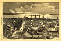
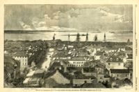
Caption: 'The city of Charleston, South Carolina.--[see page 62.]' Also identified in image: Broad Street, "Mercury" office, Custom-house, Castle Pinckney, Fort Moultrie, Fort Sumter and Morris Island. [full date January 26, 1861.]
Caption: 'The city of Charleston, South Carolina, looking seaward, and showing the burned district.--[see next page.]' Identified in image are: Broad Street, "Mercury" office, Custom-house, Castle Pinckney, Fort Moultrie, Fort Sumter and Morris Island. [full date December 28, 1861.]
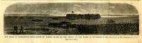
Caption: 'The Siege of Charleston--evacuation of Morris Island by the Rebels on the night of September 6, 1863.--sketched by Mr. Theodore R. Davis. [see page 621.]' [full date September 26, 1863.]
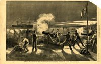
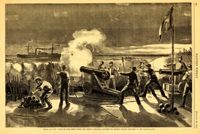
Caption: 'Firing on the "Star of the West" from the South Carolina battery on Morris Island, January 10, 1861.--[see page 54.]' [full date January 26, 1861]
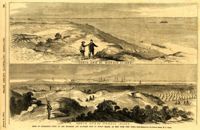
Caption: 'Siege of Charleston--views of the Northern and Southern ends of Morris Island, as seen from Fort Craig.--from sketches by our Special Artist, W.T. Crane.' Caption at top: 'North end of Morris Island.' Caption at bottom: 'South end of Morris Island.' [full date August 29, 1863.]
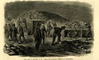
Caption (in German): 'Belagerung von Charleston, S.C.--Bauen von bombenfesten Gewoelben auf Morris Island.' {Siege of Charleston, S.C.--Building of bombproof bunkers on Morris Island.}
Caption: 'Firing on the "Star of the West" from the South Carolina battery on Morris Island, January 10, 1861.--[see page 54.]' [full date January 26, 1861]