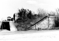
Battery Thomson, 2013 I'on Avenue. View of Observation Post, North (Front) elevation. Sullivans Island, S.C.;6.5" x 10" B/W photo. Box 16, Folder 2-13-7. One copy.
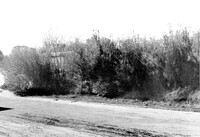
Battery Thomson, 2013 I'on Avenue. View of North (Front) elevation, looking West. Sullivans Island, S.C.;10" x 6.5" B/W photo. Box 16, Folder 2-13-7. One copy.
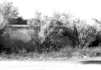
Battery Thomson, 2013 I'on Avenue. View of North (Front) elevation, looking East. Sullivans Island, S.C.;10" x 6.5" B/W photo. Box 16, Folder 2-13-7. One copy.
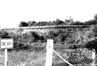
Battery Thomson, 2013 I'on Avenue. View of North (Front) elevation, looking West. Sullivans Island, S.C.;6.5" x 10" B/W photo. Box 16, Folder 2-13-7. One copy.
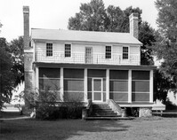
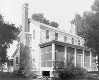
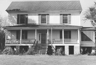
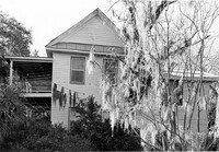
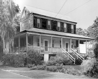
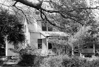
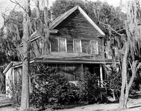
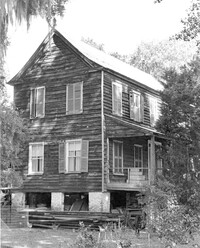
Oak Grove Plantation, Leadenwah Drive. View of NE (Side and Front) elevation. Wadmalaw Island, S.C.;8" x 10" B/W photo. Box 17, Folder 2-14-3. One copy.
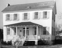
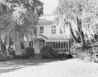
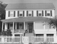
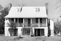
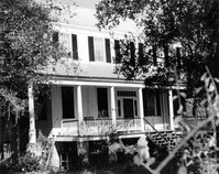
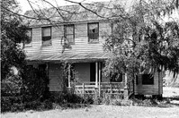
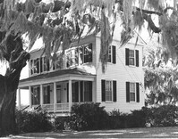
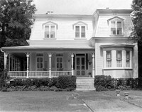
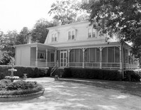
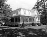
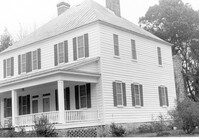
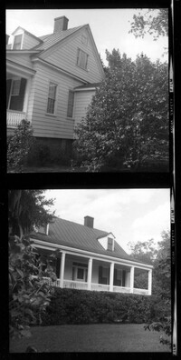
Rockville Historic District - Joseph LaRoche House, Sea Island Yacht Club Road. View of North (Front) elevation. Wadmalaw Island, S.C.;8" x 10" B/W photo. Box 17, Folder 2-14-6. One copy.
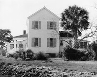
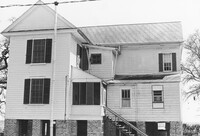
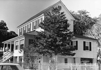
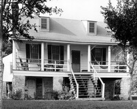
Rockville Historic District - Joseph LaRoche House, Sea Island Yacht Club Road. View of West (Side) elevation. Wadmalaw Island, S.C.;8" x 10" B/W photo. Box 17, Folder 2-14-6. One copy.
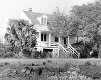
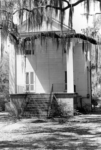
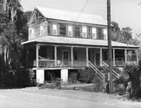
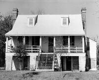
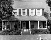
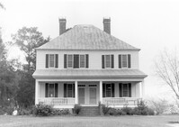
Rockville Historic District - John F. Townsend House, Sea Island Yacht Club Road. View of NE (Front and Side) elevation. Wadmalaw Island, S.C.;8" x 10" B/W photo. Box 17, Folder 2-14-7. One copy.
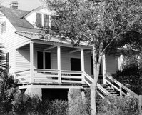
Rockville Historic District - John F. Townsend House, Sea Island Yacht Club Road. Detail View of Front Porch, NE (Front and Side) elevation.. Wadmalaw Island, S.C.;8" x 10" B/W photo. Box 17, Folder 2-14-7. One copy.
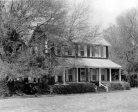
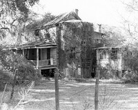
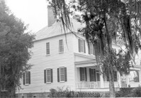
Rockville Historic District - Ladson Webb House (Exchange Plantation House), Sea Island Yacht Club Road. View of North (Front) elevation. Wadmalaw Island, S.C.;6.5" x 10" B/W photo. Box 17, Folder 2-14-8. One copy.
Rockville Historic District - Ladson Webb House (Exchange Plantation House), Sea Island Yacht Club Road. View of South (Rear) elevation. Wadmalaw Island, S.C.;6.5" x 10" B/W photo. Box 17, Folder 2-14-8. One copy.
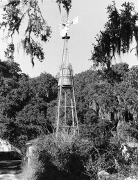
Rockville Historic District - Wilson's Windmill, Sea Island Yacht Club Road. South elevation. Wadmalaw Island, S.C.;10" x 8" B/W photo. Box 17, Folder 2-14-9. One copy.
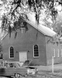
Rockville Historic District - Rockville Presbyterian Church, 2479 Sea Island Yacht Club Road. View of South (Front) elevation. Wadmalaw Island, S.C.;8" x 10" B/W photo. Box 17, Folder 2-14-10. One copy.
Rockville Historic District - Rockville Presbyterian Church, 2479 Sea Island Yacht Club Road. View of South (Front) elevation. Wadmalaw Island, S.C.;10" x 6.5" B/W photo. Box 17, Folder 2-14-10. One copy.
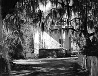
Rockville Historic District - Rockville Presbyterian Church, 2479 Sea Island Yacht Club Road. View of NW (Rear and Side) elevation. Wadmalaw Island, S.C.;6.5" x 10" B/W photo. Box 17, Folder 2-14-10. Two copies.
Rockville Historic District - Morse-Fripp House (Stanley F. Morse House, Charles E. Fripp House), Sea Island Yacht Club Road. View of South (Front) elevation. Wadmalaw Island, S.C.;8" x 10" B/W photo. Box 17, Folder 2-14-11. One copy.
Rockville Historic District - Morse-Fripp House (Stanley F. Morse House, Charles E. Fripp House), Sea Island Yacht Club Road. View of South (Front) elevation. Wadmalaw Island, S.C.;8" x 10" B/W photo. Box 17, Folder 2-14-11. One copy.
Rockville Historic District - Mary A. Whaley House, Maybank Highway. View of North (Front) elevation. Wadmalaw Island, S.C.;6.5" x 10" (and 8" x 10") B/W photo. Box 17, Folder 2-14-12. Two copies.
Rockville Historic District - Mary A. Whaley House, Maybank Highway. View of West (Side) elevation. Wadmalaw Island, S.C.;6.5" x 10" B/W photo. Box 17, Folder 2-14-12. One copy.
Rockville Historic District - Old Episcopal Rectory, Maybank Highway. View of South (Front) elevation. Wadmalaw Island, S.C.;6.5" x 10" (and 8" x 10") B/W photo. Box 17, Folder 2-14-13. Two copies.
Rockville Historic District - Old Episcopal Rectory, Maybank Highway. View of SE (Side and Front) elevation. Wadmalaw Island, S.C.;6.5" x 10" B/W photo. Box 17, Folder 2-14-13. One copy.
Rockville Historic District - Perry House, Maybank Highway. View of South (Front) elevation. Wadmalaw Island, S.C.;6.5" x 10" B/W photo. Box 17, Folder 2-14-14. One copy.
Rockville Historic District - W.E. Jenkins House (James LaRoche House), Maybank Highway. View of South (Front) elevation. Wadmalaw Island, S.C.;6.5" x 10" (and 8" x 10") B/W photo. Box 17, Folder 2-14-15. Two copies.
Rockville Historic District - W.E. Jenkins House (James LaRoche House). View of South (Front) elevation. Wadmalaw Island, S.C.;6.5" x 10" B/W photo. Box 17, Folder 2-14-15. One copy.
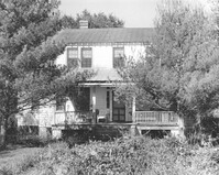
Rockville Historic District - Hagood House (Micah Jenkins House), Grace Chapel Road. View of South (Front) elevation. Wadmalaw Island, S.C.;6.5" x 10" B/W photo. Box 17, Folder 2-14-16. One copy.
Rockville Historic District - Hagood House (Micah Jenkins House), Grace Chapel Road. View of South (Front) elevation. Wadmalaw Island, S.C.;8" x 10" B/W photo. Box 17, Folder 2-14-16. One copy.
Rockville Historic District - Hagood House (Micah Jenkins House), Grace Chapel Road. View of South (Front) elevation. Wadmalaw Island, S.C.;8" x 10" B/W photo. Box 17, Folder 2-14-16. One copy.
Rockville Historic District - Stevens House (Major Daniel Jenkins House), Maybank Highway. View of South (Front) elevation. Wadmalaw, S.C.;6.5" x 10" (and 8" x 10") B/W photo. Box 17, Folder 2-14-17. Two copies.
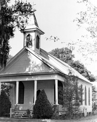
Rockville Historic District - Grace Episcopal Chapel (Grace Epsicopal Church), Grace Chapel Road. View of Front and Side elevation. Wadmalaw, S.C.;10" x 6.5" (and 10" x 8") B/W photo. Box 17, Folder 2-14-18. Two copies.
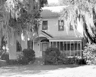
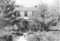
Rockville Historic District - Cornelia J. Whaley House, Grace Chapel Road. View of South (Front) elevation. Wadmalaw Island, S.C.;8" x 6.5" (and 6.5" x 10") B/W photo. Box 17, Folder 2-14-19. Three copies.
Rockville Historic District - Cornelia J. Whaley House, Grace Chapel Road. View of South (Front) elevation. Wadmalaw Island, S.C.;6.5" x 10" B/W photo. Box 17, Folder 2-14-19. One copy.
Rockville Historic District - Cornelia J. Whaley House, Grace Chapel Road. View of SW (Front and Side) elevation. Wadmalaw Island, S.C.;6.5" x 10" B/W photo. Box 17, Folder 2-14-19. Two copies.
Rockville Historic District - Fanny Wilson House, Grace Chapel Road. View of South (Front) elevation. Wadmalaw Island, S.C.;6.5" x 10" B/W photo. Box 17, Folder 2-14-20. One copy.
Rockville Historic District - John F. Sosnowski House, Grace Chapel Road. View of South (Front) elevation. Wadmalaw Island, S.C.;8" x 10" B/W photo. Box 17, Folder 2-14-21. One copy.
Rockville Historic District - John F. Sosnowski House, Grace Chapel Road. View of SW (Front and Side) elevation. Wadmalaw Island, S.C.;8" x 10" B/W photo. Box 17, Folder 2-14-21. One copy.
Rockville Historic District - Presbyterian Manse, Sea Island Yacht Club Road. View of South (Front) elevation. Wadmalaw Island, S.C.;8" x 10" B/W photo. Box 17, Folder 2-14-22. One copy.
Rockville Historic District - Edward D. Bailey House, Sea Island Yacht Club Road. View of East (Front) elevation. Wadmalaw Island, S.C.;6.5" x 10" (and 8" x 10") B/W photo. Box 17, Folder 2-14-23. Two copies.
Rockville Historic District - Welch's Lane House (Welches Lane House), Sea Island Yacht Club Road. View of SE (Front and Side) elevation. Wadmalaw Island, S.C.;8" x 10" B/W photo. Box 17, Folder 2-14-24. One copy.
Rockville Historic District - Welch's Lane House (Welches Lane House), Sea Island Yacht Club Road. View of South (Front) elevation. Wadmalaw Island, S.C.;6.5" x 10" (and 8" x 10") B/W photo. Box 17, Folder 2-14-24. Two copies.
St. James Bethel Church (Zion Chapel, St. James Bethel AME Church), 5305 Maybank Highway. View of NW (Front and Side) elevation. Wadmalaw Island, S.C.;10" x 8" B/W photo. Box 17, Folder 2-14-25. One copy.
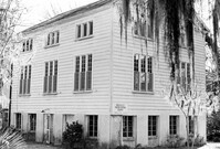
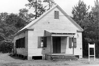
Old Lincolnville Town Hall (Williams Graded School), near intersection of East Randolph Street and East Pinckney Street. View of South (Front) elevation. Lincolnville, S.C.;6.5" x 10" B/W photo. Box 17, Folder 2-15-2. Two copies.
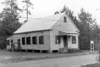
Old Lincolnville Town Hall (Williams Graded School), near intersection of East Randolph Street and East Pinckney Street. View of SW (Front and Side) elevation. Lincolnville, S.C.;6.5" x 10" B/W photo. Box 17, Folder 2-15-2. Two copies.
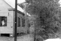
Old Lincolnville Town Hall (Williams Graded School), near intersection of East Randolph Street and East Pinckney Street. View of North (Rear) elevation. Lincolnville, S.C.;6.5" x 10" B/W photo. Box 17, Folder 2-15-2. Three copies.
Old Lincolnville Town Hall (Williams Graded School), near intersection of East Randolph Street and East Pinckney Street. View of SE (Front and Side) elevation. Lincolnville, S.C.;6.5" x 10" B/W photo. Box 17, Folder 2-15-2. Three copies.
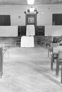
Old Lincolnville Town Hall (Williams Graded School), near intersection of East Randolph Street and East Pinckney Street. View of interior. Lincolnville, S.C.;10" x 6.5" B/W photo. Box 17, Folder 2-15-2. Three copies.
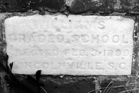
Old Lincolnville Town Hall (Williams Graded School), near intersection of East Randolph Street and East Pinckney Street. Detail View of cornerstone. Lincolnville, S.C.;6.5" x 10" B/W photo. Box 17, Folder 2-15-2. Three copies.
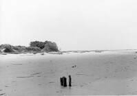
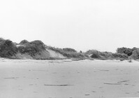
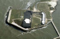
Folly Island Staging Area (Battery Green, U.S. Coast Guard Loran Station, Folly North Site), Address restricted. View facing North. Folly Beach, S.C.;8" x 10" B/W photo. Box 17, Folder 2-16-1. One copy.
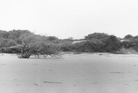
Folly Island Staging Area (Battery Green, U.S. Coast Guard Loran Station, Folly North Site), Address restricted. View facing WNW. Folly Beach, S.C.;8" x 10" B/W photo. Box 17, Folder 2-16-1. One copy.
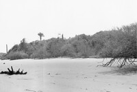
Folly Island Staging Area (Battery Green, U.S. Coast Guard Loran Station, Folly North Site), Address restricted. View facing NNW. Folly Beach, S.C.;8" x 10" B/W photo. Box 17, Folder 2-16-1. One copy.
Folly Island Staging Area (Battery Green, U.S. Coast Guard Loran Station, Folly North Site), Address restricted. View facing NW. Folly Beach, S.C.;8" x 10" B/W photo. Box 17, Folder 2-16-1. One copy.
Folly Island Staging Area (Battery Green, U.S. Coast Guard Loran Station, Folly North Site), Address restricted. View facing WSW. Folly Beach, S.C.;8" x 10" B/W photo. Box 17, Folder 2-16-1. One copy.
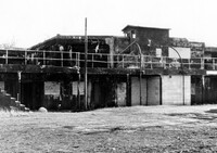
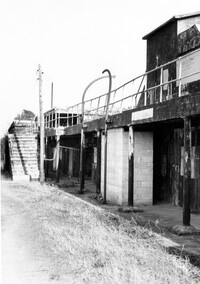
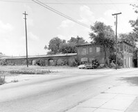
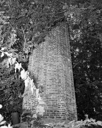
S.C. Railroad Car Shop (AAA Downtown Storage), 44 Line Street. View of SW elevation Charleston, S.C.;8" x 10" B/W photo. Box 18, Folder: Charleston: 44 Line Street, South Carolina Car Shop. One copy.
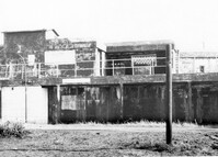
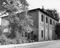
S.C. Railroad Car Shop (AAA Downtown Storage), 44 Line Street. Detail View of SW elevation Charleston, S.C.;8" x 10" B/W photo. Box 18, Folder: Charleston: 44 Line Street, South Carolina Car Shop. Two copies
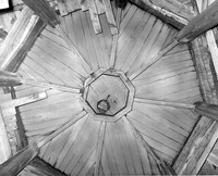
S.C. Railroad Car Shop (AAA Downtown Storage), 44 Line Street. Unidentified detail. Charleston, S.C.;10" x 8" B/W photo. Box 18, Folder: Charleston: 44 Line Street, South Carolina Car Shop. One copy.
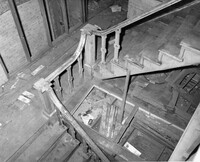
S.C. Railroad Car Shop (AAA Downtown Storage), 44 Line Street. Interior View - Detail of Staircase. Charleston, S.C.;8" x 10" B/W photo. Box 18, Folder: Charleston: 44 Line Street, South Carolina Car Shop. One copy.
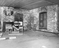
S.C. Railroad Car Shop (AAA Downtown Storage), 44 Line Street. Interior View - Unidentified Room. Charleston, S.C.;8" x 10" B/W photo. Box 18, Folder: Charleston: 44 Line Street, South Carolina Car Shop. One copy.
S.C. Railroad Car Shop (AAA Downtown Storage), 44 Line Street. Interior View - Unidentified Detail. Charleston, S.C.;8" x 10" B/W photo. Box 18, Folder: Charleston: 44 Line Street, South Carolina Car Shop. One copy.
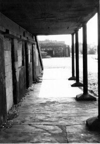
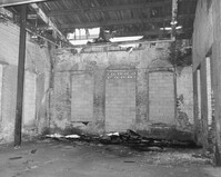
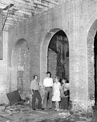
S.C. Railroad Car Shop (AAA Downtown Storage), 44 Line Street. Interior View. Charleston, S.C.;8" x 10" B/W photo. Box 18, Folder: Charleston: 44 Line Street, South Carolina Car Shop. One copy.
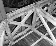
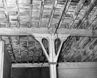
S.C. Railroad Car Shop (AAA Downtown Storage), 44 Line Street. Interior View - Detail of Support Beam. Charleston, S.C.;8" x 10" B/W photo. Box 18, Folder: Charleston: 44 Line Street, South Carolina Car Shop. One copy.
S.C. Railroad Car Shop (AAA Downtown Storage), 44 Line Street. Interior View - Unidentified Detail. Charleston, S.C.;8" x 10" B/W photo. Box 18, Folder: Charleston: 44 Line Street, South Carolina Car Shop. One copy.
S.C. Railroad Car Shop (AAA Downtown Storage), 44 Line Street. Interior View. Charleston, S.C.;8" x 10" B/W photo. Box 18, Folder: Charleston: 44 Line Street, South Carolina Car Shop. One copy.
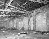
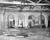
S.C. Railroad Car Shop (AAA Downtown Storage), 44 Line Street. Interior View showing damage to brick arches. Charleston, S.C.;8" x 10" B/W photo. Box 18, Folder: Charleston: 44 Line Street, South Carolina Car Shop. One copy.
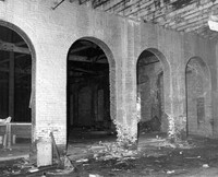
S.C. Railroad Car Shop (AAA Downtown Storage), 44 Line Street. Interior View. Charleston, S.C.;10" x 8" B/W photo. Box 18, Folder: Charleston: 44 Line Street, South Carolina Car Shop. Two copies.
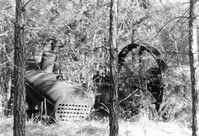
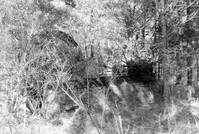
Fairlawn Plantation (Hugh Rose Plantation), Off of Guerins Bridge Road, adjacent to the Francis Marion National Forest. View of Corn Sheller.;10" x 6.5" B/W photo. Box 19, Folder: Charleston County: Christ Church: Fairlawn Plantation. One copy.
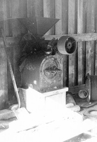
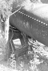
Fairlawn Plantation (Hugh Rose Plantation), Off of Guerins Bridge Road, adjacent to the Francis Marion National Forest. Detail View of Steam Engine for Rice Mill.;6.5" x 10" B/W photo. Box 19, Folder: Charleston County: Christ Church: Fairlawn Plantation. One copy.
Fairlawn Plantation (Hugh Rose Plantation), Off of Guerins Bridge Road, adjacent to the Francis Marion National Forest. Detail View of Steam Engine for Rice Mill.;6.5" x 10" B/W photo. Box 19, Folder: Charleston County: Christ Church: Fairlawn Plantation. One copy.
Fairlawn Plantation (Hugh Rose Plantation), Off of Guerins Bridge Road, adjacent to the Francis Marion National Forest. Detail View of Steam Engine for Rice Mill.;6.5" x 10" B/W photo. Box 19, Folder: Charleston County: Christ Church: Fairlawn Plantation. One copy.
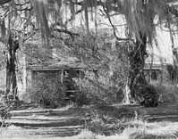
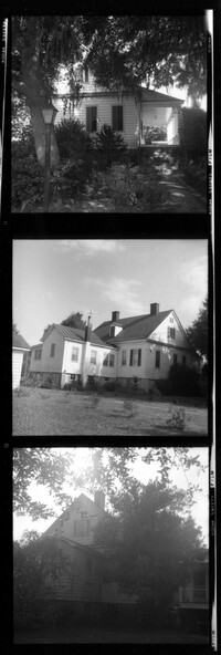
Rockville Historic District - Julia Evelina Whaley House (Marc Tolbert House), Grace Chapel Road. View of SE (Side and Front) elevation. House destroyed by fire in 1984. Wadmalaw Island, S.C.;10" x 8" B/W photo. Box 20, Folder: Charleston County: Wadmalaw Island: Julia Evelina Whaley House. Five copies.
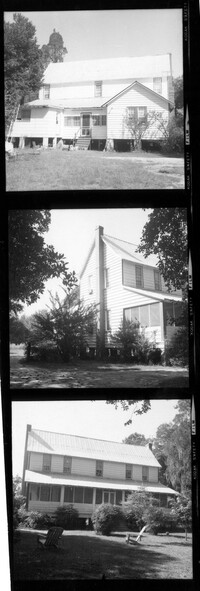
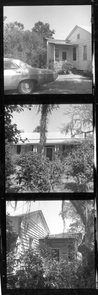
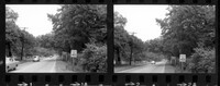
T. Hayne Stall House. Contact Sheet 1 - View of Front and Side elevations. Stallsville Area. Summerville, S.C.;7.5" x 2.25" B/W photo. Box 17, Folder 3-1-1. One Copy.
Collins House. Contact Sheet 1 - View of Front and Side elevations. Stallsville Area. Summerville, S.C.;7.5" x 2.25" B/W photo. Box 17, Folder 3-1-1. One Copy.
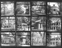
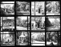
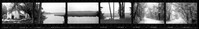
Ashley River Historic District (Highway 61 Historical District). Contact Sheet 6 - Views of Ashley Hall Plantation, Old St. Andrews Parish Church, and Ashley River Road. Charleston, S.C.;1" x 9" B/W photo. Box 20, Folder: Miscellaneous Photos: Scanned Contact Sheets. One copy.