Search
« Previous |
901 - 950 of 5,490
|
Next »
Search Results
Date:
1886
Description:
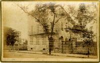
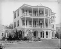
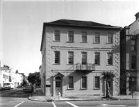
Caption: 'Cook's Earthquake Views of Charleston and Vicinity. Taken after the 31st of August, 1886. No.114, residence Col. Inglesby.' Charleston city directory for 1886 shows Charles Inglesby at 20 Meeting Street.
Date:
1886
Description:
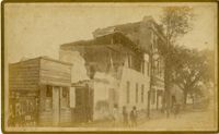
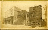
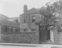
Caption: 'Cook's Earthquake Views of Charleston and Vicinity. Taken after the 31st of August, 1886. No.85, Chapel Street.'
Date:
1886
Description:
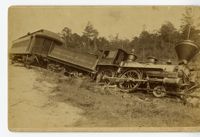
Caption: 'Earthquake, August 31st, 1886. No.634, Wrecked at Langley. Aiken and Vicinity.'
Date:
1880 and 1930
Description:
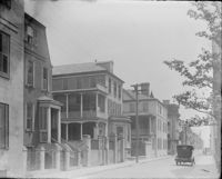
93 Rutledge Avenue
Date:
1880 and 1930
Description:
70 to 76 Tradd Street
Date:
1880 and 1930
Description:
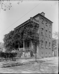
20 Montagu Street, Dr. James Moultrie House
Date:
1886
Description:
Caption: 'Cook's Earthquake Views of Charleston and Vicinity. Taken after the 31st of August, 1886. No.152, Meeting Street, above Hasel [Hasell].'
Date:
1886
Description:
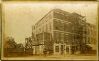
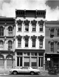
Caption: 'Cook's Earthquake Views of Charleston and Vicinity. Taken after the 31st of August, 1886. No.139, 119 Meeting Street, front.'
Date:
1880 and 1930
Description:
89 to 91 Church Street, Catfish Row
Date:
1880 and 1930
Description:
6 Gibbes Street, Parker-Drayton House
Date:
1880 and 1930
Description:
Society Street, Slave Quarters
Date:
1880 and 1930
Description:
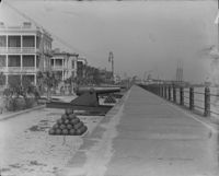
High Battery Looking North
Date:
1929-06-13
Description:
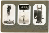
Image #433 (4.5" x 2.75"): "6-13-29. West cantilever arm, from below, erected to L17. Traveler B at L16."; Image #434 (4.5" x 2.75"): "6-13-29. Looking toward Pier 8 (at 1050' distance) from top of Pier 9. (See 431)."; Image #435 (4.5" x 2.75"): "6-13-29. Joint L17, cantilever arm side, showing opening for 10" [diameter] jacking pin and for jack, to control suspended span while cantilevered. (See 488).";Three 4.5" x 2.75" B/W photos numbered 433, 434, 435
Date:
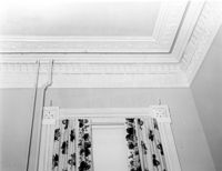
1977-1983
Description:
69 Barre Street, Gov. Thomas Bennett House, ca. 1822. Main House - Interior View. 2nd Floor - SE Room; Detail of window architrave and cornice. 4" x 5" B/W photo.
Date:
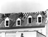
1977-1983
Description:
85 - 87 Broad Street, Josiah Smith Tenement, ca. 1795. Detail View of roof showing 1978 fire damage, South (Rear) elevation. 4" x 5" B/W photo.
Date:
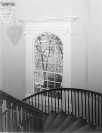
1977-1983
Description:
69 Barre Street, Gov. Thomas Bennett House, ca. 1822. Main House - Interior View. 2nd Floor - Stairwell; Detail of window. 4" x 5" B/W photo.
Date:
1977-1983
Description:
77 Church Street, Louis Danjou House (Brewton's Corner), ca. 1810. View of NE (Front and Side) elevation. 4" x 5" B/W photo.
Date:
1977-1983
Description:
4 Orange Street, Samuel Carne House, ca. 1770. Main House - Interior View. 1st Floor - East Room, NW wall. 4" x 5" B/W photo.
Date:
1977-1983
Description:
143 - 145 Church Street, Alexander Perronneau Tenements, ca. 1740. View of East (Front) elevation. 4" x 5" B/W photo.
Date:
1977-1983
Description:
48 Elizabeth Street, Aiken-Rhett House, ca.1818. Courtyard - View of South elevation from North side of Main House. 4" x 5" B/W photo.
Date:
1977-1983
Description:
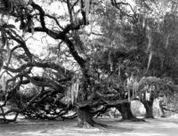
Berkley County, Mulberry Plantation, ca. 1714. Driveway - View of Live Oak trees. 4" x 5" B/W photo.
Date:
1977-1983
Description:
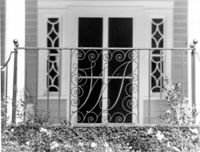
Charleston County, William Seabrook-Dodge Plantation, ca. 1810. Detail View of monogrammed iron railing, 1st Floor portico, South (Front) elevation. 4" x 5" B/W photo.
Date:
1977-1983
Description:
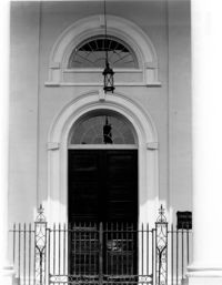
126 Coming Street, Cathedral Church of St. Luke and St. Paul, ca. 1816. Detail View of center entry door, West (Front) elevation. 4" x 5" B/W photo.
Date:
1977-1983
Description:
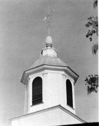
Charleston County, Edisto Island Presbyterian Church, ca. 1831. Church - Detail View of cupola. 4" x 5" B/W photo.
Date:
1977-1983
Description:
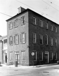
Camden Depot of the S.C.R.R., ca. 1845; South side of Ann Street between Meeting and King Streets. Attributed to E.B. White, architect. View of entry from the NW. 4" x 5" B/W photo.
Date:
1977-1983
Description:
49 Broad Street, Benjamin Smith Building, ca. 1740. View of North (Front) elevation. 4" x 5" B/W photo.
Date:
1886-1916
Description:
8 x 8.3 cm photographic print
Date:
1886
Description:
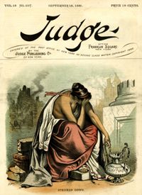
[Color image.] Caption: 'Stricken down.' [full date September 18, 1886.]
Date:
1886-1916
Description:
8.3 x 8.6 cm photographic print
Date:
1863
Description:
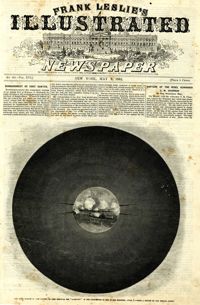
Caption: 'The bombardment of Fort Sumter, as seen through the "look out" in the pilot-house of one of the monitors, April 7.--from a sketch by our Special Artist.' [full date May 9, 1863]
Date:
1860
Description:
Caption: 'The Charleston Convention--interior of Douglas's headquarters, Hibernia (sic) Hall, Charleston, S.C.--from a sketch by our special artist.--see page 360.' [May 5, 1860.]
Date:
1977-1983
Description:
48 Elizabeth Street, Aiken-Rhett House, ca.1818. Main House - View of West (Side) elevation. 4" x 5" B/W photo.
Date:
1892-1916
Description:
15.5 x 10.5 cm photographic print
Date:
1860
Description:
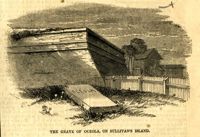
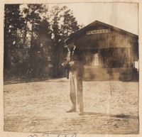
Caption: 'The grave of Oceola (sic), on Sullivan's Island.' [full date December 1, 1860.]
Date:
1977-1983
Description:
43, 45, 47 Broad Street, ca. 1855. View of NW (Front and Side) elevation. 4" x 5" B/W photo.
Date:
1977-1983
Description:
36 Broad Street, ca. 1803. View of North (Front) elevation. 4" x 5" B/W photo.
Date:
1977-1983
Description:
38 Broad Street, ca. 1801. View of South (Front) elevation. 4" x 5" B/W photo.
Date:
1977-1983
Description:
37 Broad Street, ca. 1794. View of North (Front) elevation. 4" x 5" B/W photo.
Date:
1977-1983
Description:
41 Broad Street, ca. 1835. View of North (Front) elevation. 4" x 5" B/W photo.
Date:
1977-1983
Description:
42 Broad Street, ca. 1797. View of South (Front) elevation. 4" x 5" B/W photo.
Date:
1977-1983
Description:
40 Broad Street, ca. 1740. View of South (Front) elevation. 4" x 5" B/W photo.
Date:
1886-1916
Description:
8.1 x 8.8 cm photographic print
Date:
1960
Description:
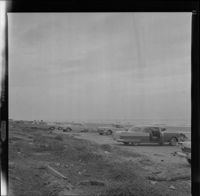
Black and white negative of cars parked on a beach at Hilton Head Island, 1960; 6 x 6.5 cm.
Date:
1886-1916
Description:
8.5 x 8.5 cm photographic print
Date:
1929-06-07
Description:
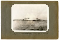
Unnumbered Image (5" x 7"): "Progress on Cooper River Span, June 7, 1929 at 4:30 P.M.";One 5" x 7" B/W photo
Date:
1929-05-17
Description:
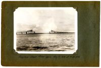
Unnumbered Image (5" x 7"): "Progress - Cooper River Span, May 17, 1929 at 4:30 P.M.";One 5" x 7" B/W photo
Date:
1892-1916
Description:
3.5 x 4.7 cm photographic print
Date:
1892-1916
Description:
3.7 x 4.8 cm photographic print
Date:
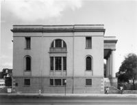
1977-1983
Description:
100 Meeting Street, Fireproof Building, ca. 1822. View of West (Side) elevation 4" x 5" B/W photo.
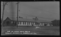
Date:
1941-1949
Description:
Black and white negative of back exterior of mess hall at Parris Island, 1941 - 1949; 14 x 8.5 cm.