Search
« Previous |
1,501 - 1,600 of 1,638
|
Next »
Search Results
Date:
1977-1983
Description:
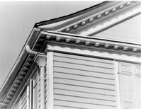
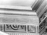
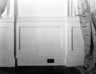
Charleston County, Oak Island Plantation, ca. 1830. Interior View. 1st Floor - SW Room. Detail of cornice and door architrave. 4" x 5" B/W photo.
Date:
1977-1983
Description:
Charleston County, Oak Island Plantation, ca. 1830. Interior View. 1st Floor - NE Room, South wall. 4" x 5" B/W photo.
Date:
1977-1983
Description:
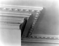
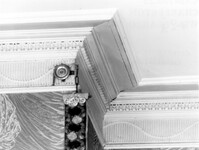
Charleston County, Oak Island Plantation, ca. 1830. Interior View. 1st Floor - NE Room, Detail of cornice. 4" x 5" B/W photo.
Date:
1977-1983
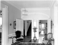
Description:
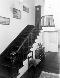
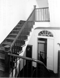
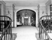
Charleston County, Oak Island Plantation, ca. 1830. Interior View. 1st Floor - North Stair Hall, looking North. 4" x 5" B/W photo.
Date:
1977-1983
Description:
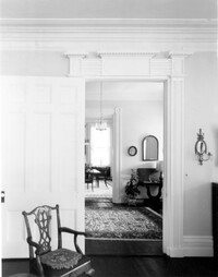
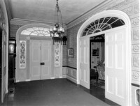
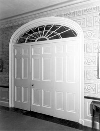
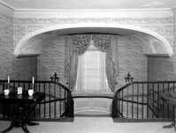
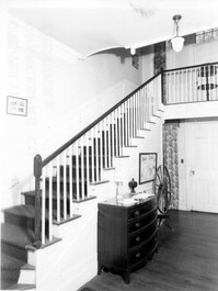
Charleston County, Oak Island Plantation, ca. 1830. Interior View. 1st Floor - Stair Landing, looking South to 2nd Floor Hall and 1st Floor twin doors to South Entry Hall. 4" x 5" B/W photo.
Date:
1977-1983
Description:
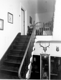
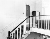
Charleston County, Oak Island Plantation, ca. 1830. Interior View. 2nd Floor - North Stair Hall, looking North. 4" x 5" B/W photo.
Date:
1977-1983
Description:
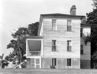
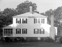
Charleston County, Oak Island Plantation, ca. 1830. View of West (Side) elevation. 4" x 5" B/W photo.
Date:
1977-1983
Description:
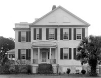
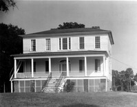
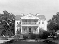
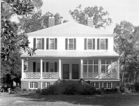
Charleston County, Oak Island Plantation, ca. 1830. View of South (Front) elevation. 4" x 5" B/W photo.
Date:
1977-1983
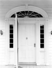
Description:
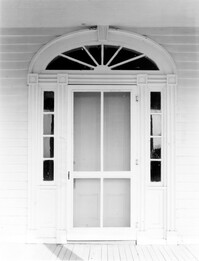
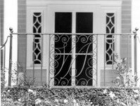
Charleston County, Oak Island Plantation, ca. 1830. Detail View of portico entry, South (Front) elevation. 4" x 5" B/W photo.
Date:
1977-1983
Description:
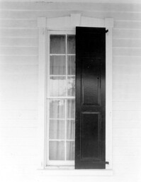
Charleston County, Oak Island Plantation, ca. 1830. Detail View of door, West (Side) elevation. 4" x 5" B/W photo.
Date:
1977-1983
Description:
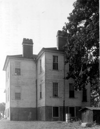
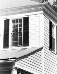
Charleston County, Oak Island Plantation, ca. 1830. Detail View of stair window and parapet wall, North (Rear) elevation. 4" x 5" B/W photo.
Date:
1977-1983
Description:
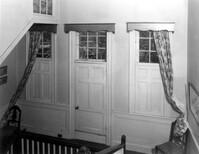
Charleston County, Oak Island Plantation, ca. 1830. Interior View. 1st Floor - South Entry Hall, looking North. 4" x 5" B/W photo.
Date:
1977-1983
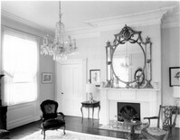
Description:
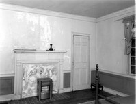
Charleston County, Oak Island Plantation, ca. 1830. Interior View. 1st Floor - SW Room, North wall. 4" x 5" B/W photo.
Date:
1977-1983
Description:
Charleston County, Oak Island Plantation, ca. 1830. Interior View. 1st Floor - SW Room, looking West through Hall to SE Room. 4" x 5" B/W photo.
Date:
1977-1983
Description:
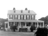
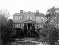
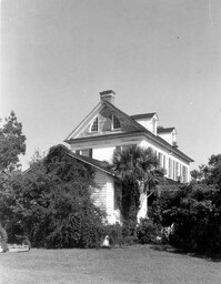
Charleston County (2695 Laurel Hill Road), Prospect Hill Plantation, ca. 1861. View of South (Front) elevation. 4" x 5" B/W photo.
Date:
1977-1983
Description:
Charleston County (2695 Laurel Hill Road), Prospect Hill Plantation, ca. 1861. View of East (Side) elevation. 4" x 5" B/W photo.
Date:
1977-1983
Description:
Charleston County (2695 Laurel Hill Road), Prospect Hill Plantation, ca. 1861. View of North (Rear) elevation. 4" x 5" B/W photo.
Date:
1977-1983
Description:
Charleston County (2695 Laurel Hill Road), Prospect Hill Plantation, ca. 1861. View of NW (Side and Rear) elevation. 4" x 5" B/W photo.
Date:
1977-1983
Description:
Charleston County (2695 Laurel Hill Road), Prospect Hill Plantation, ca. 1861. Detail View of Ground Floor entry, South (Front) elevation. 4" x 5" B/W photo.
Date:
1977-1983
Description:
Charleston County (2695 Laurel Hill Road), Prospect Hill Plantation, ca. 1861. Detail View of main entry, South (Front) elevation. 4" x 5" B/W photo.
Date:
1977-1983
Description:
Charleston County (2695 Laurel Hill Road), Prospect Hill Plantation, ca. 1861. Detail View of 1st Floor window, South (Front) elevation. 4" x 5" B/W photo.
Date:
1977-1983
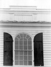
Description:
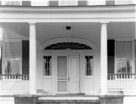
Charleston County (2695 Laurel Hill Road), Prospect Hill Plantation, ca. 1861. Detail View of portico and cornice elements. 4" x 5" B/W photo.
Date:
1977-1983
Description:
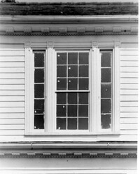
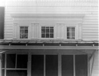
Charleston County (2695 Laurel Hill Road), Prospect Hill Plantation, ca. 1861. Detail View of 2nd Floor central window, South (Front) elevation. 4" x 5" B/W photo.
Date:
1977-1983
Description:
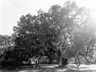
Charleston County, William Seabrook-Dodge Plantation, ca. 1810. View of live oak tree. 4" x 5" B/W photo.
Date:
1977-1983
Description:
Charleston County, William Seabrook-Dodge Plantation, ca. 1810. View of South (Front) elevation. 4" x 5" B/W photo.
Date:
1977-1983
Description:
Charleston County, William Seabrook-Dodge Plantation, ca. 1810. Detail View of monogrammed iron railing, 1st Floor portico, South (Front) elevation. 4" x 5" B/W photo.
Date:
1977-1983
Description:
Charleston County, William Seabrook-Dodge Plantation, ca. 1810. Detail View of main entry on 1st Floor, South (Front) elevation. 4" x 5" B/W photo.
Date:
1977-1983
Description:
Charleston County, William Seabrook-Dodge Plantation, ca. 1810. Detail View of main entry on 2nd Floor portico, South (Front) elevation. 4" x 5" B/W photo.
Date:
1977-1983
Description:
Charleston County, William Seabrook-Dodge Plantation, ca. 1810. Detail View of 2nd Floor cornice. 4" x 5" B/W photo.
Date:
1977-1983
Description:
Charleston County, William Seabrook-Dodge Plantation, ca. 1810. Detail View of gable window, East (Side) elevation. 4" x 5" B/W photo.
Date:
1977-1983
Description:
Charleston County, William Seabrook-Dodge Plantation, ca. 1810. Interior View. 1st Floor - Hall, looking North to Stairhall. 4" x 5" B/W photo.
Date:
1977-1983
Description:
Charleston County, William Seabrook-Dodge Plantation, ca. 1810. Interior View. 1st Floor - Hall, looking South to entry. 4" x 5" B/W photo.
Date:
1977-1983
Description:
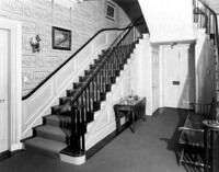
Charleston County, William Seabrook-Dodge Plantation, ca. 1810. Interior View. 1st Floor - Hall, Detail of stairway. 4" x 5" B/W photo.
Date:
1977-1983
Description:
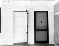
Charleston County, William Seabrook-Dodge Plantation, ca. 1810. Interior View. 1st Floor - Hall, Detail of door to SW Room. 4" x 5" B/W photo.
Date:
1977-1983
Description:
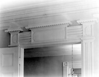
Charleston County, William Seabrook-Dodge Plantation, ca. 1810. Interior View. 1st Floor - Hall, Detail of cornice. 4" x 5" B/W photo.
Date:
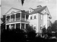
1977-1983
Description:
Charleston County, William Seabrook-Dodge Plantation, ca. 1810. View of SE (Front and Side) elevation. 4" x 5" B/W photo.
Date:
1977-1983
Description:
Charleston County, William Seabrook-Dodge Plantation, ca. 1810. Interior View. 1st Floor - SE Room, North wall. 4" x 5" B/W photo.
Date:
1977-1983
Description:
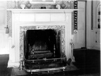
Charleston County, William Seabrook-Dodge Plantation, ca. 1810. Interior View. 1st Floor - SE Room, North wall. Detail of mantle. 4" x 5" B/W photo.
Date:
1977-1983
Description:
Charleston County, William Seabrook-Dodge Plantation, ca. 1810. Interior View. 1st Floor - SE Room, Detail of cornice. 4" x 5" B/W photo.
Date:
1977-1983
Description:
Charleston County, William Seabrook-Dodge Plantation, ca. 1810. Interior View. 1st Floor - SE Room, Detail of window spandrel and wainscot. 4" x 5" B/W photo.
Date:
1977-1983
Description:
Charleston County, William Seabrook-Dodge Plantation, ca. 1810. Interior View. 2nd Floor - Hall, looking South from stair landing. 4" x 5" B/W photo.
Date:
1977-1983
Description:
Charleston County, William Seabrook-Dodge Plantation, ca. 1810. Interior View. 2nd Floor - Stairhall, looking North. 4" x 5" B/W photo.
Date:
1977-1983
Description:
Charleston County, William Seabrook-Dodge Plantation, ca. 1810. Interior View. 2nd Floor - SE Room, North wall. 4" x 5" B/W photo.
Date:
1977-1983
Description:
Charleston County, William Seabrook-Dodge Plantation, ca. 1810. Interior View. 2nd Floor - SE Room, North wall. Detail of mantle. 4" x 5" B/W photo.
Date:
1977-1983
Description:
Charleston County, William Seabrook-Dodge Plantation, ca. 1810. Interior View. 2nd Floor - SE Room, Detail of cornice. 4" x 5" B/W photo.
Date:
1977-1983
Description:
Charleston County, William Seabrook-Dodge Plantation, ca. 1810. Interior View. 2nd Floor - Detail of window spandrel, wainscot cap and marbleized base. 4" x 5" B/W photo.
Date:
1977-1983
Description:
Charleston County, William Seabrook-Dodge Plantation, ca. 1810. View of East (Side) elevation. 4" x 5" B/W photo.
Date:
1977-1983
Description:
Charleston County, William Seabrook-Dodge Plantation, ca. 1810. View of North (Rear) elevation. 4" x 5" B/W photo.
Date:
1977-1983
Description:
Charleston County, William Seabrook-Dodge Plantation, ca. 1810. View of NW (Rear and Side) elevation. 4" x 5" B/W photo.
Date:
1977-1983
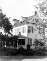
Description:
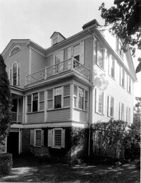
Charleston County, William Seabrook-Dodge Plantation, ca. 1810. View of SW (Front and Side) elevation. 4" x 5" B/W photo.
Date:
1977-1983
Description:
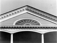
Charleston County, William Seabrook-Dodge Plantation, ca. 1810. Detail View of portico pediment, South (Front) elevation. 4" x 5" B/W photo.
Date:
1977-1983
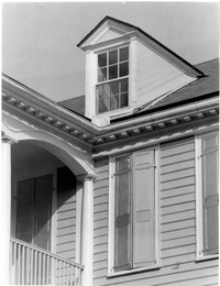
Description:
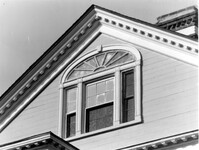
Charleston County, William Seabrook-Dodge Plantation, ca. 1810. Detail View of dormer and cornice, South (Front) elevation. 4" x 5" B/W photo.
Date:
1977-1983
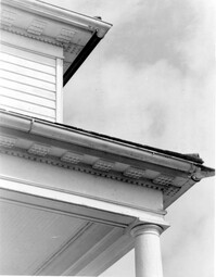
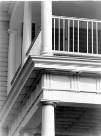
Description:
Charleston County, William Seabrook-Dodge Plantation, ca. 1810. Detail View of portico (1st Floor) cornice, South (Front) elevation. 4" x 5" B/W photo.
Date:
1977-1983
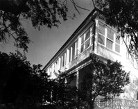
Description:
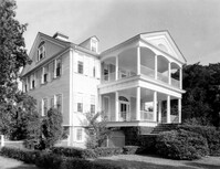
Charleston County, Seaside Plantation (Locksley Hall), ca. 1810. View of SE (Front and Side) elevation. 4" x 5" B/W photo.
Date:
1977-1983
Description:
Charleston County, Seaside Plantation (Locksley Hall), ca. 1810. View of West (Side) elevation. 4" x 5" B/W photo.
Date:
1977-1983
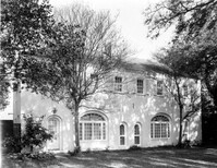
Description:
Orangeburg County, Rocks Plantation (The Rocks), ca. 1805. Main House - View of South (Front) elevation. 4" x 5" B/W photo.
Date:
1977-1983
Description:
Orangeburg County, Rocks Plantation (The Rocks), ca. 1805. Main House - View of East (Side) elevation. 4" x 5" B/W photo.
Date:
1977-1983
Description:
Orangeburg County, Rocks Plantation (The Rocks), ca. 1805. Main House - Interior View. 1st Floor - SE Room, Detail of wainscot. 4" x 5" B/W photo.
Date:
1977-1983
Description:
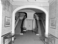
Orangeburg County, Rocks Plantation (The Rocks), ca. 1805. Main House - Interior View. 1st Floor - Stair Hall, West and North walls. 4" x 5" B/W photo.
Date:
1977-1983
Description:
Orangeburg County, Rocks Plantation (The Rocks), ca. 1805. Main House - Interior View. 2nd Floor - Landing, North end of Hall. 4" x 5" B/W photo.
Date:
1977-1983
Description:
Orangeburg County, Rocks Plantation (The Rocks), ca. 1805. Main House - Interior View. 2nd Floor - Stair Landing. 4" x 5" B/W photo.
Date:
1977-1983
Description:
Orangeburg County, Rocks Plantation (The Rocks), ca. 1805. Main House - Interior View. 2nd Floor - NW Room, South wall. 4" x 5" B/W photo.
Date:
1977-1983
Description:
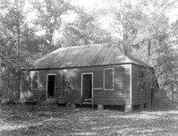
Orangeburg County, Rocks Plantation (The Rocks), ca. 1805. Slave Cabin - View of SE (Front and Side) elevation. 4" x 5" B/W photo.
Date:
1977-1983
Description:
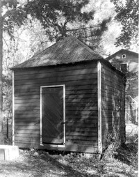
Orangeburg County, Rocks Plantation (The Rocks), ca. 1805. Smokehouse - View of SE (Front and Side) elevation. 4" x 5" B/W photo.
Date:
1977-1983
Description:
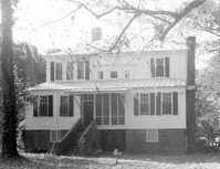
Orangeburg County, Rocks Plantation (The Rocks), ca. 1805. Main House - View of North (Rear) elevation, 4" x 5" B/W photo.
Date:
1977-1983
Description:
Orangeburg County, Rocks Plantation (The Rocks), ca. 1805. Main House - View of West (Side) elevation. 4" x 5" B/W photo.
Date:
1977-1983
Description:
Orangeburg County, Rocks Plantation (The Rocks), ca. 1805. Main House - Detail View of house and portico cornice, SE (Front and Side) elevation. 4" x 5" B/W photo.
Date:
1977-1983
Description:
Orangeburg County, Rocks Plantation (The Rocks), ca. 1805. Main House - Detail View of windows over stair landing, North (Rear) elevation. 4" x 5" B/W photo.
Date:
1977-1983
Description:
Orangeburg County, Rocks Plantation (The Rocks), ca. 1805. Main House - Detail View of entries to SE and SW Rooms, South (Front) elevation. 4" x 5" B/W photo.
Date:
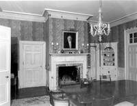
1977-1983
Description:
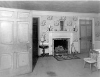
Orangeburg County, Rocks Plantation (The Rocks), ca. 1805. Main House - Interior View. 1st Floor - SE Room, North wall. 4" x 5" B/W photo.
Date:
1977-1983
Description:
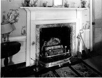
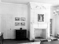
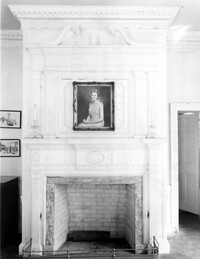
Orangeburg County, Rocks Plantation (The Rocks), ca. 1805. Main House - Interior View. 1st Floor - SE Room, North wall. Detail of mantle and chimneypiece. 4" x 5" B/W photo.
Date:
1977-1983
Description:
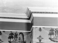
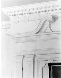
Orangeburg County, Rocks Plantation (The Rocks), ca. 1805. Main House - Interior View. 1st Floor - SE Room, North wall. Detail of cornice and overmantle. 4" x 5" B/W photo.
Date:
1977-1983
Description:
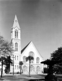
328 Meeting Street, Citadel Square Baptist Church, ca. 1856. View of West (Front) elevation. 4" x 5" B/W photo.
Date:
1977-1983
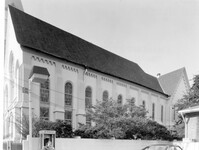
Description:
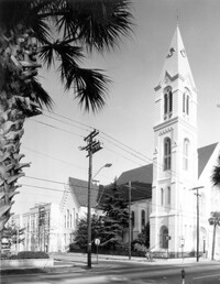
328 Meeting Street, Citadel Square Baptist Church, ca. 1856. View of North (Side) elevation. 4" x 5" B/W photo.
Date:
1977-1983
Description:
328 Meeting Street, Citadel Square Baptist Church, ca. 1856. View of South (Side) elevation. 4" x 5" B/W photo.
Date:
1977-1983
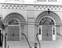
Description:
328 Meeting Street, Citadel Square Baptist Church, ca. 1856. Detail View of doors, West (Front) elevation. 4" x 5" B/W photo.
Date:
1977-1983
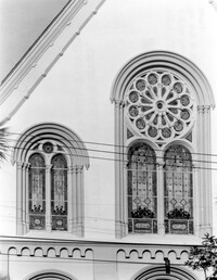
Description:
328 Meeting Street, Citadel Square Baptist Church, ca. 1856. Detail View of clerestory windows, West (Front) elevation. 4" x 5" B/W photo.
Date:
1977-1983
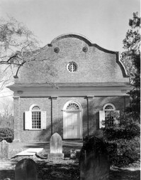
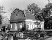
Description:
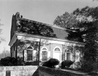
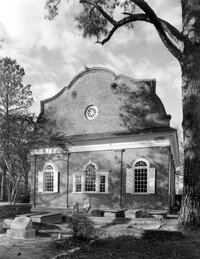
Berkeley County, St. Stephen's Church, ca. 1767. View of West (Front) elevation. 4" x 5" B/W photo.
Date:
1977-1983
Description:
Berkeley County, St. Stephen's Church, ca. 1767. View of SW (Front and Side) elevation. 4" x 5" B/W photo.
Date:
1977-1983
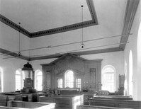
Description:
Berkeley County, St. Stephen's Church, ca. 1767. Interior View - Nave, pulpit, and reredos. Looking East. 4" x 5" B/W photo.
Date:
1977-1983
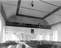
Description:
Berkeley County, St. Stephen's Church, ca. 1767. Interior View - Nave, looking West. 4" x 5" B/W photo.
Date:
1977-1983
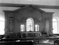
Description:
Berkeley County, St. Stephen's Church, ca. 1767. Detail View of reredos and altar. 4" x 5" B/W photo.
Date:
1977-1983
Description:
Berkeley County, St. Stephen's Church, ca. 1767. Detail View of reredos at Venetian window. 4" x 5" B/W photo.
Date:
1977-1983
Description:
Berkeley County, St. Stephen's Church, ca. 1767. Detail View of reredos entablature and pilaster capitals. 4" x 5" B/W photo.
Date:
1977-1983
Description:
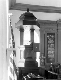
Berkeley County, St. Stephen's Church, ca. 1767. Detail View of pulpit. 4" x 5" B/W photo.
Date:
1977-1983
Description:
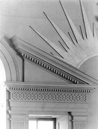
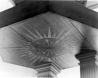
Berkeley County, St. Stephen's Church, ca. 1767. Detail View of soffitt in pulpit roof. 4" x 5" B/W photo.
Date:
1977-1983
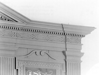
Description:
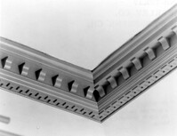
Berkeley County, St. Stephen's Church, ca. 1767. Detail View of cornice (between flat and cove ceilings). 4" x 5" B/W photo.
Date:
1977-1983
Description:
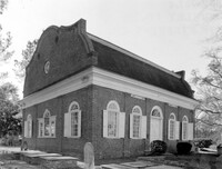
Berkeley County, St. Stephen's Church, ca. 1767. View of South (Side) elevation. 4" x 5" B/W photo.
Date:
1977-1983
Description:
Berkeley County, St. Stephen's Church, ca. 1767. View of East (Rear) elevation. 4" x 5" B/W photo.
Date:
1977-1983
Description:
Berkeley County, St. Stephen's Church, ca. 1767. View of NE (Rear and Side) elevation. 4" x 5" B/W photo.
Date:
1977-1983
Description:
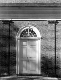
Berkeley County, St. Stephen's Church, ca. 1767. Detail View of entry, West (Front) elevation. 4" x 5" B/W photo.
Date:
1977-1983
Description:
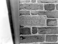
Berkeley County, St. Stephen's Church, ca. 1767. Detail View of plaque bearing architect/builder's name (A. Howard), South (Side) elevation (located at SE corner). 4" x 5" B/W photo.
Date:
1977-1983
Description:
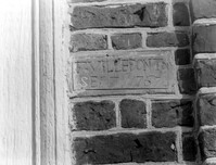
Berkeley County, St. Stephen's Church, ca. 1767. Detail View of plaque bearing architect/builder's name (F. Villepontoux), South (Side) elevation (located to right of door jamb). 4" x 5" B/W photo.
Date:
1977-1983
Description:
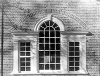
Berkeley County, St. Stephen's Church, ca. 1767. Detail View of Venetian window, East (Rear) elevation. 4" x 5" B/W photo.
Date:
1977-1983
Description:
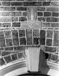
Berkeley County, St. Stephen's Church, ca. 1767. Detail View of plaque bearing mason's name (Wm. Axson) and Freemason symbol, East (Rear) elevation (located above central window). 4" x 5" B/W photo.
Date:
1977-1983
Description:
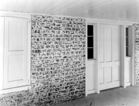
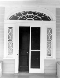
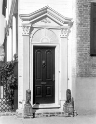
36 Hasell Street, Samuel N. Stevens Tenement, ca. 1843. Detail View of entry, South (Front) elevation. 4" x 5" B/W photo.
Date:
1977-1983
Description:
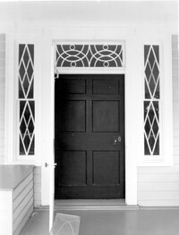
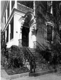
52 Hasell Street, Gibbons-Gilliland House, ca. 1843. Detail View of entry, SW (Front and Side) elevation. 4" x 5" B/W photo.
Date:
1977-1983
Description:
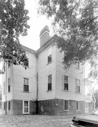
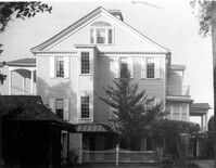
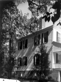
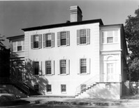
54 Hasell Street, Colonel William Rhett House, ca. 1712. View of South (Front) elevation. 4" x 5" B/W photo.
Date:
1977-1983
Description:
54 Hasell Street, Colonel William Rhett House, ca. 1712. View of West (Side) elevation. 4" x 5" B/W photo.
Date:
1977-1983
Description:
56 Hasell Street (formerly 54 Hasell Street, Colonel William Rhett House), ca. 1712. View of South (Front) elevation. Original Dependency of 54 Hasell. 4" x 5" B/W photo.