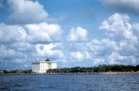
View of Battery Point (intersection of Murray Boulevard and East Battery Street) and Fort Sumter House from the Ashley River. Charleston, S.C. Originals are 35mm color slides.
A report from the mayor, city council, and various governmental departments of Charleston, S.C. for the year 1930. ??The Year Book opens with an address from the mayor, Thomas P. Stoney, followed by reports from various departments.
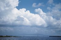
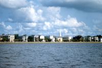
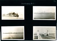
Four photographs on the page. Top left: Tugboat and other ships in a floating dry dock in the Charleston Harbor (possibly Charleston Shipbuilding). Top right: View of the Charleston waterfront from the Ashley River. Some of the landmark buildings visible in the background include St. Matthew's Church, Francis Marion Hotel, St. John's Lutheran Church, Unitarian Church, St. Philip's Church, People's Building, St. Michael's Church, and West Point Rice Mill. Bottom left: View of the Charleston waterfront from the Cooper River. Some of the landmark buildings visible in the background include Fort Sumter Hotel, St. Michael's Church, St. Philip's Church, U.S. Customhouse, and several wharves. Bottom right: Two cars on the Ashley River Bridge, one heading east and one heading west. View of the Charleston waterfront in the background.
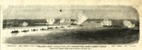
Caption: 'Panoramic view of Charleston Harbor--advance of iron-clads to the attack, April 7. Union--A. Keokuk. B. Nahunt. C. Nantucket. D. Catskill. E. Ironsides. F. Patapsco. G. Montauk. H. Passaie. K. Weehawken. Rebel--1. Morris Island sand battery. 2. Fort Wagner. 3. Battery Bee, on Cummings Point. 4. [Fort] Johnson. 5. Fort Ripley. 6. Sumter. 7. Charleston City. 8. Castle Pinckney. 9. Fort Redan. 10. Fort Moultrie. 11. Moultrie House. 12. Fort Beauregard. 13. Harbor obstructions. 14. Cooper River. 15. Ashley River.' [full date May 2, 1863.]
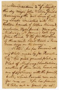
A memorandum from John Ball on Major John Wilson on resurveying the lines of lands connected with the eastern branch of the Cooper River which includes Hyde Park, Kensington, Midway and St. James Plantations.
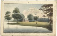
Work on paper in watercolor. Landscape with body of water in foreground leading to left side of image, trees and red building in center. Trees on either side of building and a forested area in background. Handwritten note identifies building as Pompion Hill Chapel.