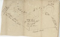
Plat of land along the Combahee River containing 5567 acres laid out for Daniel Doiley. Names associated with this plat are Daniel Doiley, Smith, Gordon Garrett, and Philips. Notable geographic locations include the Combahee River, Prince William's Parish and Farr Bluff.
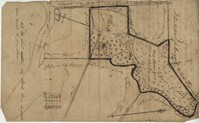
Plat of 237 acres belonging to Rob Reeves Gibbes. Detailed marsh and high land along with the location and outline of a house. Names associated with this plat are Robert Reeve Gibbes, Nathaniel Heyward, John Gibbes, Thomas Gibbes, and Lewis Gibbes. Notable geographic locations include the Combahee River, Tupelo Swamp, and Charleston District.
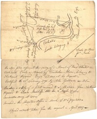
56 acre plot of land given to Radcliffe, the plot of land is bordering Cuckolds Creek, shows surrounding property owners, no land type detail or identification. Names associated with this plat are Thomas Radcliffe, Nathaniel Heyward, John Goddard and James Heyward. Notable geographic locations include Cuckolds Creek, Combahee River and St. Bartholomew's Parish.
The Roslin Plantation journal, kept by Archibald Simpson Johnston, documented enslaved people and slave labor on an antebellum plantation for two years (1813-1815). The journal documents correspondence, equipment, planting and harvesting, livestock, slaves and supplies related to the plantation. There are detailed descriptions of tasks and number of enslaved people working each task, particularly tasks regarding growing cotton and rice and maintainining those fields.