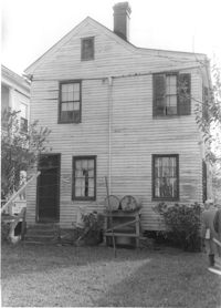
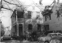
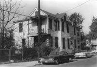
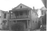
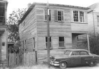
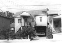
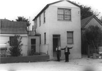
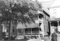
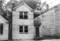
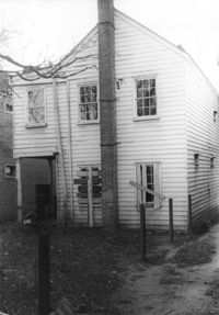
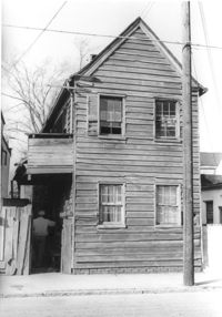
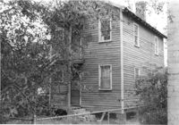
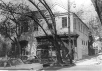
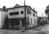
House (rear view) on site affected by the construction of the Crosstown. Address: 112 Sheppard Street. Surveyor notations on back of photo: "Dkt.: 10.524. Property owner: Alston O. Crum, Est. Tract: 146. Station: 19+50 Rt. S.B. lane. Date: Dec. 2, 1964. In R/W - Bought." [See collection description for explanation of surveyor notations.]
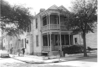
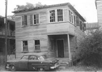
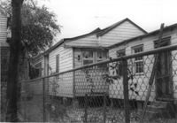
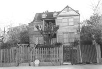
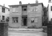
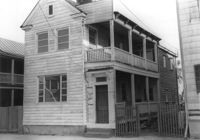
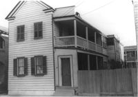
House on site affected by the construction of the Crosstown. Address: 114 Sheppard Street. Surveyor notations on back of photo: "Dkt.: 10.524. Property owner: Lillian M. Anderson, Est. Tract: 145. Station: 19+20 Rt. S.B. lane. Date: Dec. 2, 1964. In R/W - Bought." [See collection description for explanation of surveyor notations.]
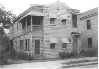
House on site affected by the construction of the Crosstown. Address: 114 Sheppard Street. Surveyor notations on back of photo: "Dkt.: 10.524. Property owner: Lillian M. Anderson, Est. Tract: 145. Station: 19+20 Rt. S.B. lane. Date: Dec. 2, 1964. In R/W - Bought." [See collection description for explanation of surveyor notations.]
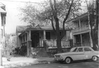
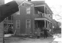
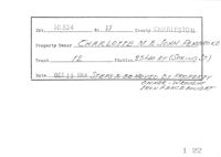
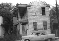
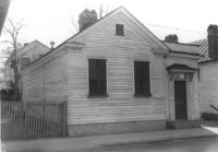
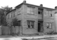
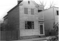
House on site affected by the construction of the Crosstown. Address: 124 Sheppard Street. Surveyor notations on back of photo: "Dkt.: 10.524. Property owner: Reynard P. Hill, Esq. Tract: 135. Station: 17+05 Lt. S.B. lane. Date: Dec. 2, 1964. In R/W - Bought." [See collection description for explanation of surveyor notations.]
House on site affected by the construction of the Crosstown. Address: 124 Sheppard Street. Surveyor notations on back of photo: "Dkt.: 10.524. Property owner: Reynard P. Hill, Esq. Tract: 135. Station: 17+05 Lt. S.B. lane. Date: Dec. 2, 1964. In R/W - Bought." [See collection description for explanation of surveyor notations.]
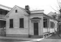
House on site affected by the construction of the Crosstown. Address: 126 Sheppard Street. Surveyor notations on back of photo: "Dkt.: 10.524. Property owner: Nathaniel M. Johnson. Tract: 134. Station: 16+70 Lt. S.B. lane. Date: Dec. 2, 1964. In R/W - Bought." [See collection description for explanation of surveyor notations.]
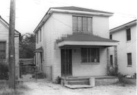
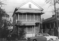
House on site affected by the construction of the Crosstown. Address: 122 Sheppard Street. Surveyor notations on back of photo: "Dkt.: 10.524. Property owner: Archie B. Hollins. Tract: 136. Station: 17+40 Lt. S.B. lane. Date: Dec. 2, 1964. In R/W - Bought." [See collection description for explanation of surveyor notations.]
House on site affected by the construction of the Crosstown. Address: 117 Bogard Street. Surveyor notations on back of photo: "Dkt.: 10.524. Property owner: Paul Mack. Tract: 56. Station: 74+25 Rt. Date: Oct. 14, 1964." [See collection description for explanation of surveyor notations.]
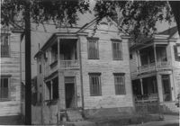
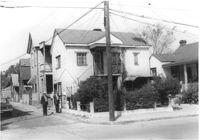
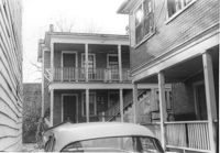
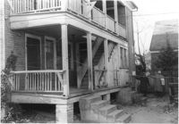
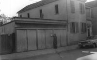
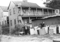
House on corner of Sheppard and Ashe Streets (rear and side views), on site affected by the construction of the Crosstown. Address: 125 Sheppard Street. Surveyor notations on back of photo: "Dkt.: 10.524. Property owner: Joseph A. Moore, et al. Tract: 130. Station: 91+90 Rt. Date: Dec. 2, 1964. In R/W - Bought." [See collection description for explanation of surveyor notations.]
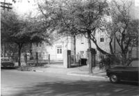
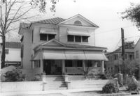
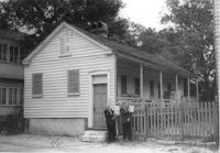
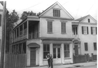
House on corner of Sheppard and Ashe Streets, on site affected by the construction of the Crosstown. Address: 125 Sheppard Street. View of street corner. Surveyor notations on back of photo: "Dkt.: 10.524. Property owner: Joseph A. Moore, et al. Tract: 130. Station: 91+90 Rt. Date: Dec. 2, 1964. In R/W - Bought." [See collection description for explanation of surveyor notations.]
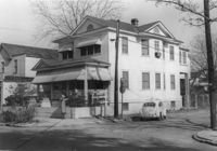
Mitchell Elementary School, on site affected by the construction of the Crosstown. Address: 132 Sheppard Street. Surveyor notations on back of photo: "Dkt.: 10.524. Property owner: Charleston County School Dist. #20. Tract: 131. Station: 91+45 Lt. Date: Dec. 2, 1964. Moving item." [See collection description for explanation of surveyor notations.]
House on Sheppard Street (rear view) on site affected by the construction of the Crosstown. Address: 131½ Sheppard Street [131 Sheppard Street]. Surveyor notations on back of photo: "Dkt.: 10.524. Property owner: William Delestine, et al. Tract: 127. Station: 89+60 Rt. Date: Dec. 2, 1964. Proximity." [See collection description for explanation of surveyor notations.]
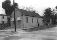
House (corner view) on site affected by the construction of the Crosstown. Address: 122 Bogard Street. View of street corner. Surveyor notations on back of photo: "Dkt.: 10.524. Property owner: Anthony E. Walker. Tract: 51. Station: 10+20 Rt. (Bogard Street). Date: Oct. 14, 1964." [See collection description for explanation of surveyor notations.]
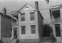
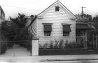
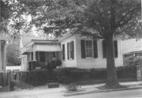
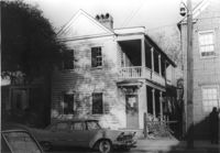
House on site affected by the construction of the Crosstown. Address: 151 President Street. Surveyor notations on back of photo: "Dkt.: 10.524. Property owner: Norman Bonneau. Tract: 33. Station: 68+35 Rt. Date: Oct. 13, 1964. In R/W - Bought." [See collection description for explanation of surveyor notations.]
House on site affected by the construction of the Crosstown. Address: 151 President Street. Surveyor notations on back of photo: "Dkt.: 10.524. Property owner: Norman Bonneau. Tract: 33. Station: 68+35 Rt. Date: Oct. 13, 1964. In R/W - Bought." [See collection description for explanation of surveyor notations.]
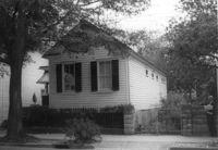
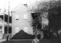
House on site affected by the construction of the Crosstown. Address: 153 President Street. Surveyor notations on back of photo: "Dkt.: 10.524. Property owner: Joe Aue. Tract: 34. Station: 68+60 CL. Date: Oct. 13, 1964. In R/W - Bought." [See collection description for explanation of surveyor notations.]
House on site affected by the construction of the Crosstown. Address: 153 President Street. Surveyor notations on back of photo: "Dkt.: 10.524. Property owner: Joe Aue. Tract: 34. Station: 68+60 CL. Date: Oct. 13, 1964. In R/W - Bought." [See collection description for explanation of surveyor notations.]
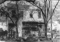
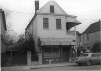
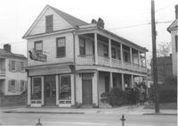
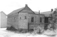
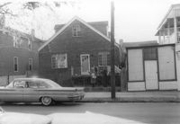
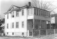
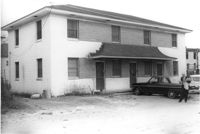
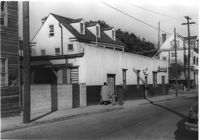
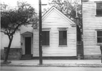
House on site affected by the construction of the Crosstown. Address: 203 Spring Street. First story is Riley's Beauty Shop. Surveyor notations on back of photo: "Dkt.: 10.524. Property owner: Samuel Riley. Tract: 169. Station: 21+65 Rt. Spring Street. Date: Dec. 2, 1964. Condemned." [See collection description for explanation of surveyor notations.]
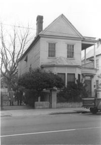
House on site affected by the construction of the Crosstown. Address: 201 Spring Street. Surveyor notations on back of photo: "Dkt.: 10.524. Property owner: Alex B. Beall, et al. Tract: 170. Station: 22+05 Rt. Spring Street. Date: Dec. 2, 1964. In R/W - Bought." [See collection description for explanation of surveyor notations.]
House on site affected by the construction of the Crosstown. Address: 201 Spring Street. Surveyor notations on back of photo: "Dkt.: 10.524. Property owner: Alex B. Beall, et al. Tract: 170. Station: 22+05 Rt. Spring Street. Date: Dec. 2, 1964. In R/W - Bought." [See collection description for explanation of surveyor notations.]
House on site affected by the construction of the Crosstown. Address: 112 Sheppard Street. Surveyor notations on back of photo: "Dkt.: 10.524. Property owner: Alston O. Crum, Est. Tract: 146. Station: 19+50 Rt. S.B. lane. Date: Dec. 2, 1964. In R/W - Bought." [See collection description for explanation of surveyor notations.]
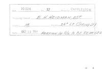
Example of information written on back of photograph: Docket Number, Route, County, Property Owner, Tract, Station, Date, and added note pertaining to right-of-way.
Example of information written on back of photograph: Docket Number, Route, County, Property Owner, Tract, Station, Date, and added note pertaining to right-of-way.
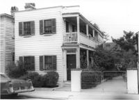
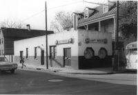
Carl's House (corner view) on site affected by the construction of the Crosstown. Address: 493 Rutledge Avenue. View of street corner. Surveyor notations on back of photo: "Dkt.: 10.524. Property owner: Elise C. Goldberg, et al. Tract: 105. Station: 84+40 Rt. Date: Dec. 1, 1964. In R/W - Bought." [See collection description for explanation of surveyor notations.]
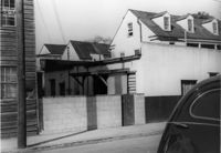
Rear portion of Carl's House, a structure (restaurant or bar) on a site affected by the construction of the Crosstown. Address: 493 Rutledge Avenue. Surveyor notations on back of photo: "Dkt.: 10.524. Property owner: Elise C. Goldberg, et al. Tract: 105. Station: 84+40 Rt. Date: Dec. 1, 1964. In R/W - Bought." [See collection description for explanation of surveyor notations.]
House on site affected by the construction of the Crosstown. Address: 197 Spring Street. First story is Jones Dry Cleaners and Laundry. Corner of Spring Street and Wescott Court. Surveyor notations on back of photo: "Dkt.: 10.524. Property owner: Annie Henrietta Masche. Tract: 172. Station: 22+85 Rt. Spring Street. Date: Dec. 2, 1964. Condemned." [See collection description for explanation of surveyor notations.]
House on site affected by the construction of the Crosstown. Address: 197 Spring Street. First story is Jones Dry Cleaners and Laundry. Corner of Spring Street and Wescott Court. Surveyor notations on back of photo: "Dkt.: 10.524. Property owner: Annie Henrietta Masche. Tract: 172. Station: 22+85 Rt. Spring Street. Date: Dec. 2, 1964. Condemned." [See collection description for explanation of surveyor notations.]
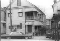
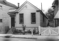
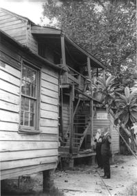
House on site affected by the construction of the Crosstown. Address: 211 Spring Street. "Furnished Rooms" sign posted by door. Surveyor notations on back of photo: "Dkt.: 10.524. Property owner: Freda C. Doscher. Tract: 165. Station: 19+70 Rt. Spring Street. Date: Dec. 2, 1964. Condemned." [See collection description for explanation of surveyor notations.]
House on site affected by the construction of the Crosstown. Address: 10 Kennedy Street. Surveyor notations on back of photo: "Dkt.: 10.524. Property owner: Lucille Beall. Tract: 93. Station: 81+50 CL. Date: Dec. 1, 1964. In R/W - Bought." [See collection description for explanation of surveyor notations.]
House on site affected by the construction of the Crosstown. Address: 167 Line Street. Surveyor notations on back of photo: "Dkt.: 10.524. Property owner: C.F. Pequette, Est. Tract: 91. Station: 81+15 Lt. Date: Dec. 1, 1964." [See collection description for explanation of surveyor notations.]
House on site affected by the construction of the Crosstown. Address: 270 Ashley Avenue. Surveyor notations on back of photo: "Dkt.: 10.524. Property owner: J. Arthur Brown. Tract: 90. Station: 80+50 Lt. Date: Dec. 1, 1964." [See collection description for explanation of surveyor notations.]
House (rear view) on site affected by the 167 Line Street. Surveyor notations on back of photo: "Dkt.: 10.524. Property owner: C.F. Pequette, Est. Tract: 91. Station: 81+15 Lt. Date: Dec. 1, 1964." [See collection description for explanation of surveyor notations.]
House (freedman's cottage) on site affected by the construction of the Crosstown. Address: 118 Bogard Street. Surveyor notations on back of photo: "Dkt.: 10.524. Property owner: Marion Holmes Wright, Est., et al. Tract: 62. Station: 75+10 CL Lt. Date: Oct. 14, 1964. Partially in R/W." [See collection description for explanation of surveyor notations.]
House (freedman's cottage) on site affected by the construction of the Crosstown. Address: 7 Rosemont Street. Surveyor notations on back of photo: "Dkt.: 10.524. Property owner: Lauretta Izzard. Tract: 52. Station: 72+70 Rt. Date: Oct. 14, 1964. In R/W - Bought." [See collection description for explanation of surveyor notations.]
House on site affected by the construction of the Crosstown. Address: 13 Kennedy Street. Surveyor notations on back of photo: "Dkt.: 10.524. Property owner: Frances B. Beaton, Est. Tract: 86. Station: 80+35 Rt. Date: Oct. 14, 1964. In R/W - Bought." [See collection description for explanation of surveyor notations.]
House on site affected by the construction of the Crosstown. Address: 13 Kennedy Street. Surveyor notations on back of photo: "Dkt.: 10.524. Property owner: Frances B. Beaton, Est. Tract: 86. Station: 80+35 Rt. Date: Oct. 14, 1964. In R/W - Bought." [See collection description for explanation of surveyor notations.]
House on site affected by the construction of the Crosstown. Address: 270 Ashley Avenue. View of street corner. Surveyor notations on back of photo: "Dkt.: 10.524. Property owner: J. Arthur Brown. Tract: 90. Station: 80+50 Lt. Date: Dec. 1, 1964." [See collection description for explanation of surveyor notations.]
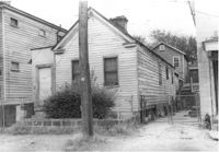
House on site affected by the construction of the Crosstown. Address: 106 Bogard Street. Surveyor notations on back of photo: "Dkt.: 10.524. Property owner: Charity Freeman. Tract: 73. Station: 76+90 Rt. Date: Oct. 14, 1964. Proximity." [See collection description for explanation of surveyor notations.]
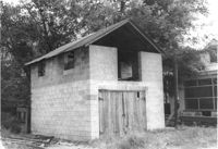
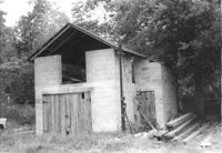
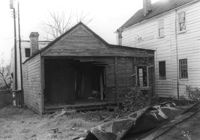
Cinder block structure (garage?) on site affected by the construction of the Crosstown. Address: 110 Bogard Street. Surveyor notations on back of photo: "Dkt.: 10.524. Property owner: Thomassina Elizabeth McCray. Tract: 72. Station: 76+60 Rt. Date: Oct. 14, 1964. In R/W - Bought." [See collection description for explanation of surveyor notations.]
Cinder block structure (garage?) on site affected by the construction of the Crosstown. Address: 110 Bogard Street. Surveyor notations on back of photo: "Dkt.: 10.524. Property owner: Thomassina Elizabeth McCray. Tract: 72. Station: 76+60 Rt. Date: Oct. 14, 1964. In R/W - Bought." [See collection description for explanation of surveyor notations.]
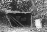
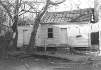
Structure (shed?) in dilapidated condition on site affected by the construction of the Crosstown. Address: 79 Kracke Street. Surveyor notations on back of photo: "Dkt.: 10.524. Property owner: Ella Lawrence, Est. Tract: 70. Station: 77+30 Lt. Date: Oct. 14, 1964. In R/W - Bought." [See collection description for explanation of surveyor notations.]
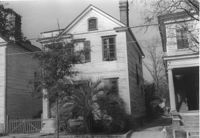
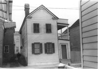
House (rear view) on site affected by the construction of the Crosstown. Address: 162A Cannon Street (address on 1951 Sanborn Map). Surveyor notations on back of photo: "Dkt.: 10.524. Property owner: J. Irvine Hoffman. Tract: 6. Station: 61+60 Rt. Date: Oct. 13, 1964. In R/W - Bought." [See collection description for explanation of surveyor notations.]
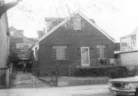
House (corner view) on site affected by the construction of the Crosstown. Address: northeast corner of Cannon Street and Wescott Street. View of street corner. Surveyor notations on back of photo: "Dkt.: 10.524. Property owner: Willie Williams. Tract: 4. Station: 61+00 CL. Date: Oct. 13, 1964. In R/W - Bought." [See collection description for explanation of surveyor notations.]
House on site affected by the construction of the Crosstown. Address: 162B Cannon Street (address on 1951 Sanborn Map). Surveyor notations on back of photo: "Dkt.: 10.524. Property owner: J. Irvine Hoffman. Tract: 5. Station: 61+40 Rt. Date: Oct. 13, 1964. In R/W - Bought." [See collection description for explanation of surveyor notations.]
House on site affected by the construction of the Crosstown. Address: 162A Cannon Street (address on 1951 Sanborn Map). Surveyor notations on back of photo: "Dkt.: 10.524. Property owner: J. Irvine Hoffman. Tract: 5. Station: 61+60 Rt. Date: Oct. 13, 1964. In R/W - Bought." [See collection description for explanation of surveyor notations.]
House on site affected by the construction of the Crosstown. Address: 162B Cannon Street (address on 1951 Sanborn Map). Surveyor notations on back of photo: "Dkt.: 10.524. Property owner: J. Irvine Hoffman. Tract: 5. Station: 61+40 Rt. Date: Oct. 13, 1964. In R/W - Bought." [See collection description for explanation of surveyor notations.]
House on site affected by the construction of the Crosstown. Address: northeast corner of Cannon Street and Wescott Street. Surveyor notations on back of photo: "Dkt.: 10.524. Property owner: Willie Williams. Tract: 4. Station: 61+00 CL. Date: Oct. 13, 1964. In R/W - Bought." [See collection description for explanation of surveyor notations.]
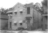
Houses on site affected by the construction of the Crosstown. Address: 81 Kracke Street. Surveyor notations on back of photo: "Dkt.: 10.524. Property owner: Jerry M. Devoe. Tract: 69. Station: 77+40 Lt. Date: Oct. 14, 1964. In R/W - Bought." [See collection description for explanation of surveyor notations.]
Side view of house on site affected by the construction of the Crosstown. Address: 26½ Kracke Street [26 Kracke Street]. Posted sign indicates it is closed by the Board of Health. Surveyor notations on back of photo: "Dkt.: 10.524. Property owner: Julie Brown. Tract: 68. Station: 77+90 Lt. Date: Oct. 14, 1964. In R/W - Bought." [See collection description for explanation of surveyor notations.]
Rear view of house on site affected by the construction of the Crosstown. Address: 112 Bogard Street. Surveyor notations on back of photo: "Dkt.: 10.524. Property owner: Susan D. Butler, Est. Tract: 65. Station: 76+00 CL Rt. Date: Oct. 14, 1964. In R/W - Bought." [See collection description for explanation of surveyor notations.]
House on site affected by the construction of the Crosstown. Address: 119 Bogard Street (rear). Surveyor notations on back of photo: "Dkt.: 10.524. Property owner: Rebecca S. Cooper. Tract: 55. Station: 73+60 Rt. Date: Oct. 14, 1964. In R/W - Bought." [See collection description for explanation of surveyor notations.]
Rear view of house on site affected by the construction of the Crosstown. Address: 117 Bogard Street. Surveyor notations on back of photo: "Dkt.: 10.524. Property owner: Paul Mack. Tract: 56. Station: 74+25 Rt. Date: Oct. 14, 1964. Proximity." [See collection description for explanation of surveyor notations.]
House on site affected by the construction of the Crosstown. Address: 119 Bogard Street. Surveyor notations on back of photo: "Dkt.: 10.524. Property owner: Rebecca S. Cooper. Tract: 55. Station: 73+90 Rt. Date: Oct. 14, 1964. In R/W - Bought." [See collection description for explanation of surveyor notations.]
House on site affected by the construction of the Crosstown. Address: 117 Bogard Street. Surveyor notations on back of photo: "Dkt.: 10.524. Property owner: Paul Mack. Tract: 56. Station: 74+25 Rt. Date: Oct. 14, 1964." [See collection description for explanation of surveyor notations.]
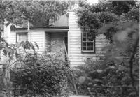
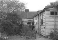
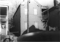
Backyard and rear view of portion of house on site affected by the construction of the Crosstown. Address: 159 President Street. Surveyor notations on back of photo: "Dkt.: 10.524. Property owner: James E. Campbell. Tract: 37. Station: 69± Lt. Date: Oct. 14, 1964." [See collection description for explanation of surveyor notations.]
House on site affected by the construction of the Crosstown. Address: 505 Rutledge Avenue. Surveyor notations on back of photo: "Dkt.: 10.524. Property owner: Carl B. Miller. Tract: 109. Station: 84+90 Lt. Date: Dec. 1, 1964. In R/W - Bought." [See collection description for explanation of surveyor notations.]
House on site affected by the construction of the Crosstown. Address: 505 Rutledge Avenue. Surveyor notations on back of photo: "Dkt.: 10.524. Property owner: Carl B. Miller. Tract: 109. Station: 84+90 Lt. Date: Dec. 1, 1964. In R/W - Bought." [See collection description for explanation of surveyor notations.]
House on site affected by the construction of the Crosstown. Address: 508 Rutledge Avenue. Surveyor notations on back of photo: "Dkt.: 10.524. Property owner: W.C. Hayes, Est. Tract: 112. Station: 86+20 Lt. Date: Dec. 1, 1964. In R/W - Bought." [See collection description for explanation of surveyor notations.]
House on site affected by the construction of the Crosstown. Address: 508 Rutledge Avenue. Surveyor notations on back of photo: "Dkt.: 10.524. Property owner: W.C. Hayes, Est. Tract: 112. Station: 86+20 Lt. Date: Dec. 1, 1964. In R/W - Bought." [See collection description for explanation of surveyor notations.]
House on site affected by the construction of the Crosstown. Address: 3 Nunan Street. Surveyor notations on back of photo: "Dkt.: 10.524. Property owner: Julia M. Pritchard. Tract: 110. Station: 84+20 Lt. Date: Dec. 1, 1964. Proximity." [See collection description for explanation of surveyor notations.]
House (freedman's cottage) on site affected by the construction of the Crosstown. Address: 165A Line Street [165 Line Street]. Surveyor notations on back of photo: "Dkt.: 10.524. Property owner: Estelle Walker. Tract: 95. Station: 82+30 Rt. Date: Dec. 1, 1964. In R/W - Bought." [See collection description for explanation of surveyor notations.]
House (freedman's cottage) on site affected by the construction of the Crosstown. Address: 165A Line Street [165 Line Street]. Surveyor notations on back of photo: "Dkt.: 10.524. Property owner: Estelle Walker. Tract: 95. Station: 82+30 Rt. Date: Dec. 1, 1964. In R/W - Bought." [See collection description for explanation of surveyor notations.]
House on site affected by the construction of the Crosstown. Address: 263 Ashley Avenue. Surveyor notations on back of photo: "Dkt.: 10.524. Property owner: Zion Presbyterian Church. Tract: 79. Station: 78+50 CL Rt. Date: Oct. 14, 1964. In R/W - Bought." [See collection description for explanation of surveyor notations.]
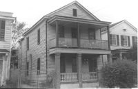
House on site affected by the construction of the Crosstown. Address: 259 Ashley Avenue. Surveyor notations on back of photo: "Dkt.: 10.524. Property owner: Madeline H. LaRoache, et al. Tract: 76. Station: 78+10 Rt. Date: Oct. 14, 1964. In R/W - Bought." [See collection description for explanation of surveyor notations.]
House on site affected by the construction of the Crosstown. Address: 259 Ashley Avenue. Surveyor notations on back of photo: "Dkt.: 10.524. Property owner: Madeline H. LaRoache, et al. Tract: 76. Station: 78+10 Rt. Date: Oct. 14, 1964. In R/W - Bought." [See collection description for explanation of surveyor notations.]
House (corner view, rear) on site affected by the construction of the Crosstown. Address: 270 Ashley Avenue. Surveyor notations on back of photo: "Dkt.: 10.524. Property owner: J. Arthur Brown. Tract: 90. Station: 80+50 Lt. Date: Dec. 1, 1964." [See collection description for explanation of surveyor notations.]
House on site affected by the construction of the Crosstown. Address: 257 Ashley Avenue. Surveyor notations on back of photo: "Dkt.: 10.524. Property owner: Daisey DeCosta Caffry. Tract: 75. Station: 77+95 Rt. Date: Oct. 14, 1964. Proximity." [See collection description for explanation of surveyor notations.]
House (freedman's cottage) on site affected by the construction of the Crosstown. Address: 9 Kennedy Street. Surveyor notations on back of photo: "Dkt.: 10.524. Property owner: Emmaline L. Purvis, Est. Tract: 88. Station: 80+92 Rt. Date: Oct. 14, 1964. Proximity." [See collection description for explanation of surveyor notations.]
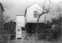
Rear view of house in dilapidated condition (freedman's cottage) on site affected by the construction of the Crosstown. Address: 5 Todd Street. Surveyor notations on back of photo: "Dkt.: 10.524. Property owner: Urban M. Kennedy, Est. Tract: 119. Station: 87+45 CL. Date:: Dec. 2, 1964. In R/W - Bought." [See collection description for explanation of surveyor notations.]
House on site affected by the construction of the Crosstown. Address: 3 Todd Street. On property of previous photos 413-414. Surveyor notations on back of photo: "Dkt.: 10.524. Property owner: John W. Bonaparte, et al. Tract: 118. Station: 87+35 Rt. Date: Dec. 1, 1964. In R/W - Bought." [See collection description for explanation of surveyor notations.]
House (rear view) on site affected by the construction of the Crosstown. Address: 502 Rutledge Avenue. Surveyor notations on back of photo: "Dkt.: 10.524. Property owner: Anna R.D. Hollings, Est. Tract: 115. Station: 86+00 Rt. Date: Dec. 1, 1964. In R/W - Bought." [See collection description for explanation of surveyor notations.]
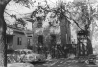
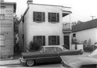
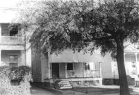
Portions of three houses on site affected by the construction of the Crosstown. Address: 501 Rutledge Avenue. Surveyor notations on back of photo: "Dkt.: 10.524. Property owner: William DeLesline, et al. Tract: 108. Station: 84±85 Lt. Date: Dec. 1, 1964." [See collection description for explanation of surveyor notations.]
House (portion of rear) on site affected by the construction of the Crosstown. Address: 501 Rutledge Avenue. Surveyor notations on back of photo: "Dkt.: 10.524. Property owner: William DeLesline, et al. Tract: 108. Station: 84±35 Lt. Date: Dec. 1, 1964. [See collection description for explanation of surveyor notations.]
House on site affected by the construction of the Crosstown. Address: 156 Line Street. Surveyor notations on back of photo: "Dkt.: 10.524. Property owner: Urban Kennedy, Est. Tract: 103. Station: 83+90 Rt. Date: Dec. 1, 1964. In R/W - Bought. [See collection description for explanation of surveyor notations.]
House on site affected by the construction of the Crosstown. Address: 156 Line Street. Surveyor notations on back of photo: "Dkt.: 10.524. Property owner: Urban Kennedy, Est. Tract: 103. Station: 83+90 Rt. Date: Dec. 1, 1964. In R/W - Bought. [See collection description for explanation of surveyor notations.]
Structure (garage?) on site affected by the construction of the Crosstown. Address: 161B Line Street [161 Line Street]. Neighboring house in picture; see US Route 17 Photo 363. Surveyor notations on back of photo: "Dkt.: 10.524. Property owner: John H. Rathjen, et al. Tract: 104. Station: 83+05 Rt. Date: Dec. 1, 1964. Owner to move from R/W." [See collection description for explanation of surveyor notations.]
House on site affected by the construction of the Crosstown. Address: 115 Bogard Street. Surveyor notations on back of photo: "Dkt.: 10.524. Property owner: Susan D. Butler, Est. Tract: 57. Station: 73+65 Lt. Date: Oct. 14, 1964. Portion in R/W to be removed." [See collection description for explanation of surveyor notations.]
House on site affected by the construction of the Crosstown. Address: 115 Bogard Street. Surveyor notations on back of photo: "Dkt.: 10.524. Property owner: Susan D. Butler, Est. Tract: 57. Station: 73+65 Lt. Date: Oct. 14, 1964. Portion in R/W to be removed." [See collection description for explanation of surveyor notations.]
House (rear view) on site affected by the construction of the Crosstown. Address: 7½ Rosemont Street [7 Rosemont Street]. Surveyor notations on back of photo: "Dkt.: 10.524. Property owner: Lauretta Izzard. Tract: 52. Station: 72+00 Rt. Date: Oct. 14, 1964. In R/W - Bought." [See collection description for explanation of surveyor notations.]
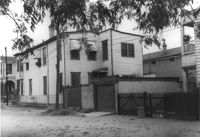
Apartment building on site affected by the construction of the Crosstown. Address: 123 Bogard Street. Surveyor notations on back of photo: "Dkt.: 10.524. Property owner: Henry W. Smith. Tract: 48. Station: 73+10 CL. Date: Oct. 14, 1964. In R/W - Bought." [See collection description for explanation of surveyor notations.]
House on site affected by the construction of the Crosstown. Address: 121 Bogard Street. Surveyor notations on back of photo: "Dkt.: 10.524. Property owner: Henry W. Smith. Tract: 48. Station: 72+85 Rt. Date: Oct. 14, 1964. In R/W - Bought." [See collection description for explanation of surveyor notations.]
House on site affected by the construction of the Crosstown. Address: 121 Bogard Street. Surveyor notations on back of photo: "Dkt.: 10.524. Property owner: Henry W. Smith. Tract: 48. Station: 72+85 Rt. Date: Oct. 14, 1964. In R/W - Bought." [See collection description for explanation of surveyor notations.]
House on site affected by the construction of the Crosstown. Address: 126 Bogard Street. Surveyor notations on back of photo: "Dkt.: 10.524. Property owner: Isiah Williams. Tract: 49. Station: 10+40 Rt. (Bogard Street). Date: Oct. 14, 1964. Proximity." [See collection description for explanation of surveyor notations.]
House on site affected by the construction of the Crosstown. Address: 122 Bogard Street. Surveyor notations on back of photo: "Dkt.: 10.524. Property owner: Anthony E. Walker. Tract: 51. Station: 10+20 Rt. (Bogard Street). Date: Oct. 14, 1964." [See collection description for explanation of surveyor notations.]
House on site affected by the construction of the Crosstown. Address: 502 Rutledge Avenue. Surveyor notations on back of photo: "Dkt.: 10.524. Property owner: Anna R.D. Hollings, Est. Tract: 115. Station: 86+00 Rt. Date: Dec. 1, 1964. In R/W - Bought." [See collection description for explanation of surveyor notations.]
House on site affected by the construction of the Crosstown. Address: 500 Rutledge Avenue. Surveyor notations on back of photo: "Dkt.: 10.524. Property owner: James F. Simmons. Tract: 116. Station: 85+90 Rt. Date: Dec. 1, 1964. In R/W - Bought." [See collection description for explanation of surveyor notations.]
House on site affected by the construction of the Crosstown. Address: 500 Rutledge Avenue. Surveyor notations on back of photo: "Dkt.: 10.524. Property owner: James F. Simmons. Tract: 116. Station: 85+90 Rt. Date: Dec. 1, 1964. In R/W - Bought." [See collection description for explanation of surveyor notations.]
House on site affected by the construction of the Crosstown. Address: 182 Spring Street. First floor appears to have been a store. Surveyor notations on back of photo: "Dkt.: 10.524. Property owner: A.J.R. Kornahrens. Tract: 27. Station: 65+75 Rt. Date: Oct. 13, 1964. In R/W - Bought." [See collection description for explanation of surveyor notations.]
Carl's House (rear and side view) on site affected by the construction of the Crosstown. Address: 493 Rutledge Avenue. Looking towards street corner. Surveyor notations on back of photo: "Dkt.: 10.524. Property owner: Elise C. Goldberg, et al. Tract: 105. Station: 84+40 Rt. Date: Dec. 1, 1964. In R/W - Bought." [See collection description for explanation of surveyor notations.]
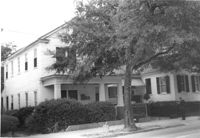
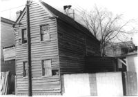
House (side view, rear) on site affected by the construction of the Crosstown. Address: 110 Sheppard Street. Surveyor notations on back of photo: "Dkt.: 10.524. Property owner: Alma L. Browning, et al. Tract: 147. Station: 19+95 CL S.B. lane. Date: Dec. 2, 1964. In R/W - Bought." [See collection description for explanation of surveyor notations.]
House on corner of Sheppard and Ashe Street, on site affected by the construction of the Crosstown. Address: 125 Sheppard Street. Surveyor notations on back of photo: "Dkt.: 10.524. Property owner: Joseph A. Moore, et al. Tract: 130. Station: 91+90 Rt. Date: Dec. 2, 1964. In R/W - Bought." [See collection description for explanation of surveyor notations.]
House on site affected by the construction of the Crosstown. Address: 122 Sheppard Street. View at street corner. Surveyor notations on back of photo: "Dkt.: 10.524. Property owner: Archie B. Hollins. Tract: 136. Station: 17+40 Lt. S.B. lane. Date: Dec. 2, 1964. In R/W - Bought." [See collection description for explanation of surveyor notations.]
House on site affected by the construction of the Crosstown. Address: 12 Todd Street. Surveyor notations on back of photo: "Dkt.: 10.524. Property owner: Buster Jones, et al. Tract: 123. Station: 88+65 CL Rt. Date: Dec. 2, 1964. In R/W - Bought." [See collection description for explanation of surveyor notations.]
House on site affected by the construction of the Crosstown. Address: 12 Todd Street. Surveyor notations on back of photo: "Dkt.: 10.524. Property owner: Buster Jones, et al. Tract: 123. Station: 88+65 CL Rt. Date: Dec. 2, 1964. In R/W - Bought." [See collection description for explanation of surveyor notations.]
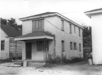
House on site affected by the construction of the Crosstown. Address: 128 Sheppard Street. Surveyor notations on back of photo: "Dkt.: 10.524. Property owner: Kawarsuan, Inc. Tract: 133. Station: 16+40 Lt. S.B. lane. Date: Dec. 2, 1964. Condemned." [See collection description for explanation of surveyor notations.]
House on site affected by the construction of the Crosstown. Address: 14 Todd Street. Surveyor notations on back of photo: "Dkt.: 10.524. Property owner: Mable E. Brown. Tract: 124. Station: 88+80 Lt. Date: Dec. 2, 1964. In R/W - Bought." [See collection description for explanation of surveyor notations.]
House on site affected by the construction of the Crosstown. Address: 14 Todd Street. Surveyor notations on back of photo: "Dkt.: 10.524. Property owner: Mable E. Brown. Tract: 124. Station: 88+80 Lt. Date: Dec. 2, 1964. In R/W - Bought." [See collection description for explanation of surveyor notations.]
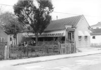
Structure (shed?) (rear view), with several household appliances (stoves?) in the yard, on site affected by the construction of the Crosstown. Address: 11 Presidents Place. Surveyor notations on back of photo: "Dkt.: 10.524. Property owner: Star Gospel Mission. Tract: 15. Station: 24+50 Rt. (Spring Street). Date: Oct. 13, 1964. Portion in R/W to be removed." [See collection description for explanation of surveyor notations.]
House (freedman's cottage) on site affected by the construction of the Crosstown. Address: 261 Ashley Avenue. Surveyor notations on back of photo: "Dkt.: 10.524. Property owner: Frank H. McGill, Estate. Tract: 77. Station: 78+40 Rt. Date: Oct. 14, 1964. In R/W - Bought." [See collection description for explanation of surveyor notations.]
Corner view of house on site affected by the construction of the Crosstown. Address: 112 Bogard Street. View of street corner. Surveyor notations on back of photo: "Dkt.: 10.524. Property owner: Susan D. Butler, Est. Tract: 65. Station: 76+00 CL Rt. Date: Oct. 14, 1964. In R/W - Bought." [See collection description for explanation of surveyor notations.]