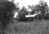
House in dilapidated condition and small outbuilding on site affected by the widening of U.S. Route 17. Presumably located in Mount Pleasant or vicinity. Surveyor notations on back of photo: "Dkt.: 10.597. Property owner: Fay Collington, Estate. Tract: 38. Station: 286± Lt. Date: Sept. 17, 1968." [See collection description for explanation of surveyor notations.]
House on site affected by the widening of U.S. Route 17. Charleston Oil Co. billboard in background. Presumably located in Mount Pleasant or vicinity. Surveyor notations on back of photo: "Dkt.: 10.597. Property owner: Luke Scoff, Est. Tract: 29. Station: 273± Rt. Date: Sept. 17, 1968." [See collection description for explanation of surveyor notations.]
Bargain Center Supermarket (side/corner view, rear) on site affected by the widening of U.S. Route 17. Presumably located in southern Charleston County. Surveyor notations on back of photo: "Dkt.: 10.600. Property owner: Vernon A. Ellis. Tract: 3. Station: 512± - 514± Rt. Date: Sept. 18, 1968." [See collection description for explanation of surveyor notations.]
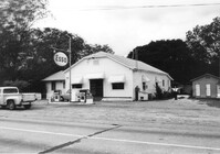
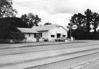
Esso gas station on site affected by the widening of U.S. Route 17. Presumably located in Mount Pleasant or vicinity. Surveyor notations on back of photo: "Dkt.: 10.597. Property owner: Mary B. McConnell. Tract: 79. Station 444+00 Lt. Date: Sept. 17, 1968." [See collection description for explanation of surveyor notations.]
Esso gas station on site affected by the widening of U.S. Route 17. Presumably located in Mount Pleasant or vicinity. Surveyor notations on back of photo: "Dkt.: 10.597. Property owner: Mary B. McConnell. Tract: 79. Station 444+00 Lt. Date: Sept. 17, 1968." [See collection description for explanation of surveyor notations.]
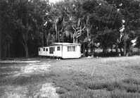
Mobile home on site affected by the widening of U.S. Route 17. Presumably located in southern Charleston County. Surveyor notations on back of photo: "Dkt.: 10.600. Property owner: John D. Postell, Jr. Tract: 15. Station: 623± Rt. Date: Sept. 18, 1968." [See collection description for explanation of surveyor notations.]
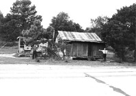
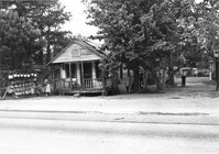
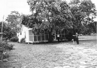
House and sweetgrass basket stand on site affected by the widening of U.S. Route 17. Presumably located in Mount Pleasant or vicinity. Surveyor notations on back of photo: "Dkt.: 10.597. Property owner: Linda Huger, Estate. Tract 84 & 85. Station: 448± Lt. Date: Sept. 17, 1968." [See collection description for explanation of surveyor notations.]
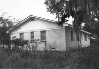
House in dilapidated condition and lot on site affected by the widening of U.S. Route 17. Presumably located in Mount Pleasant or vicinity. Surveyor notations on back of photo: "Dkt.: 10.597. Property owner: F. Gregorie, Estate. Tract: 93. Station: 458±10 Rt. Date: Sept. 17, 1968." [See collection description for explanation of surveyor notations.]
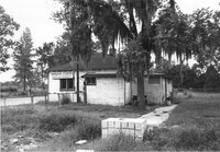
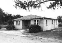
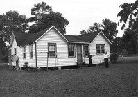
House (corner view, rear) on site affected by the widening of U.S. Route 17. Presumably located in Mount Pleasant or vicinity. Surveyor notations on back of photo: "Dkt.: 10.597. Property owner: Prince and Wilhelmina Gilliard. Tract: 92. Station: 457±10 Rt. Date: Sept. 17, 1968." [See collection description for explanation of surveyor notations.]
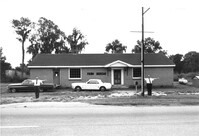
Farm Bureau building, on site affected by the widening of U.S. Route 17. Presumably located in southern Charleston County. Surveyor notations on back of photo: "Dkt.: 10.600. Property owner: Charleston County Farm Bureau. Tract: 2. Station: 507±30 Lt. Date: Sept. 18, 1968." [See collection description for explanation of surveyor notations.]
House on site affected by the widening of U.S. Route 17. Presumably located in Mount Pleasant or vicinity. Surveyor notations on back of photo: "Dkt.: 10.597. Property owner: John Gailliard. Tract: 102. Station: 466±40 Rt. Date: Sept. 17, 1968." [See collection description for explanation of surveyor notations.]
House on site affected by the widening of U.S. Route 17. Presumably located in Mount Pleasant or vicinity. Surveyor notations on back of photo: "Dkt.: 10.597. Property owner: Charles Dingle. Tract: 98. Station 462±50 Rt. Date: Sept. 17, 1968." [See collection description for explanation of surveyor notations.]
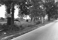
Lot on site affected by the widening of U.S. Route 17. Sign posted to tree: This land cleared by Atlantic Land Corp. Presumably located in southern Charleston County. Surveyor notations on back of photo: "Dkt.: 10.600. Property owner: Arthur J. Stark. Tract: 1. Station: 515± Lt. Date: Sept. 18, 1968." [See collection description for explanation of surveyor notations.]
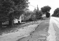
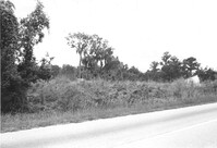
Lot on site affected by the widening of U.S. Route 17. Presumably located in southern Charleston County. Surveyor notations on back of photo: "Dkt.: 10.600. Property owner: Gas Lines, Inc. & Arthur J. Stark. Tract: 1-A. Station: 506± Lt. Date: Sept. 18, 1968." [See collection description for explanation of surveyor notations.]
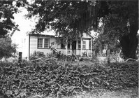
House on site affected by the widening of U.S. Route 17. Presumably located in Mount Pleasant or vicinity. Surveyor notations on back of photo: "Dkt.: 10.597. Property owner: F. Gregorie, Estate. Tract: 93. Station: 460± Rt. Date: Sept. 17, 1968." [See collection description for explanation of surveyor notations.]
House on site affected by the widening of U.S. Route 17. Presumably located in Mount Pleasant or vicinity. Surveyor notations on back of photo: "Dkt.: 10.597. Property owner: F. Gregorie, Estate. Tract: 93. Station: 460± Rt. Date: Sept. 17, 1968." [See collection description for explanation of surveyor notations.]