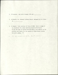
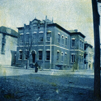
This one-page typed document discusses the historical background and describes the architecture of the building at 48 Hasell Street, St. Johannes Lutheran Church. The unknown writer references Beatrice Ravenel's book, The Architects of Charleston.
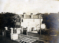
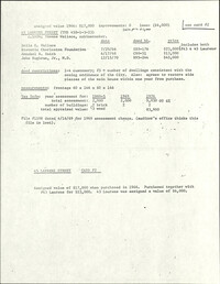
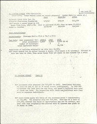
This half-page typed document discusses the Ansonborough Area Rehabilitation Program, the Revolving Fund, and restrictive covenants. The architecture of the Chancognie House at 48 Laurens Street and the home's current owner are also discussed.
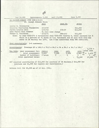
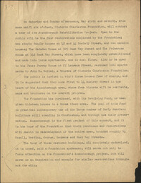
One-page typed document including historical and architectural information for 50 Laurens Street; 48 Hasell Street, St. Johannes Lutheran Church; and 54 Hasell Street, former home of Colonel William Rhett. St. Katharine's Convent is written in as the fourth property with no accompanying information.
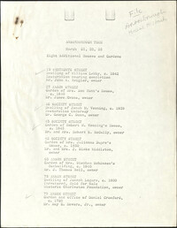
In this one-page typed document eight houses and gardens are added to the walking tour through the Ansonborough Neighborhood: 19 Wentworth Street, 57 Anson Street, 46 Society Street,43 Society Street, 63 Anson Street, 75 Anson Street, and 79 Anson Street. An approximate date of when the buildings on the property were built, as well as ownership information, is included.
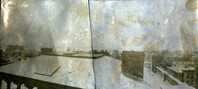
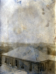
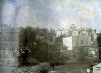
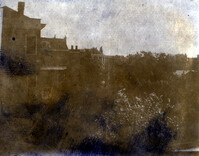
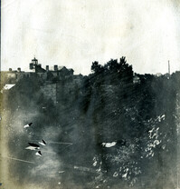
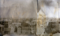
View of rooftops of Hasell Street area between Maiden Lane and Anson Street. Buildings in image include Trinity Methodist Episcopal Church and the U.S. Customs House. Page 31, Photo 1 of collection. 3.5" x 3.5" B/W photograph.
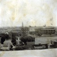
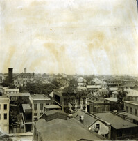
View of Charleston from rooftop at northeast corner of Wentworth and Meeting Streets, facing west, with streetcar passing. Buildings in view include Kahal Kadosh Beth Elohim Synagogue and Hirsch Israel Building. Page 22, Photo 1 of collection. 3.5" x 3.5" B/W photograph.
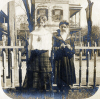
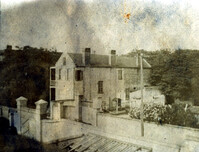
Two young women and field of oyster shells at sea wall on South Battery. William Gibbes House and 68 South Battery are in background. Page 36, Photo 1 of collection. 3.5" x 3.5" B/W photograph, original in two pieces.
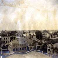
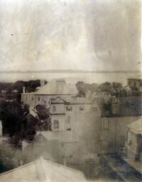
View of Charleston from rooftop of Calhoun Mansion, facing southwest. Buildings in image include Josiah Smith House and Stevens-Lathers House. Page 3, Photo 1 of collection. 6.25" x 2.75" B/W photograph, two images spliced together.
View of Charleston from rooftop of the Calhoun Mansion, facing southeast. Includes backs of buildings along Church Street, South Battery, and East Battery. Page 1, Photo 3 of collection. 3.25" x 3.5" B/W photograph.
View of Charleston from rooftop at northeast corner of Wentworth and Meeting Streets, facing northwest. Page 22, Photo 2 of collection. 3.5" x 3.5" B/W photograph.
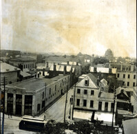
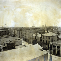
View of Charleston from rooftop in vicinity of northeast corner of Wentworth and Meeting Streets, facing south. Buildings in image include 64 Hasell, 66 Hasell, the Charleston Hotel, and St. Philip's Church steeple. Page 4, Photo 1 of collection. 3.5" x 3.5" B/W photograph.View of Charleston from rooftop in vicinity of northeast corner of Wentworth and Meeting Streets, facing south. Buildings in image include 64 Hasell, 66 Hasell, the Charleston Hotel, and St. Philip's Church steeple. Page 4, Photo 1 of collection. 3.5" x 3.5" B/W photograph.
View of Charleston from rooftop at northeast corner of Wentworth and Meeting Streets, facing southwest. Church steeples in image include the Unitarian Church and St. John's Lutheran Church. Page 2, Photo 2 of collection. 3.5" x 3.5" B/W photograph.
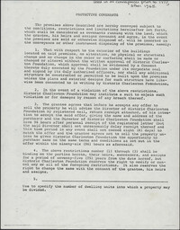
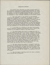
This one-page typed document provides stipulations for properties under the Historic Charleston Foundation's Protective Covenants agreement, prior to 1977 and after 1965.
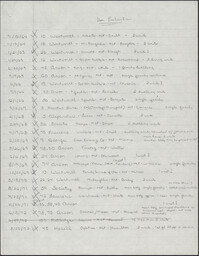
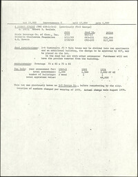
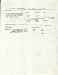
This two-page, handwritten document lists several properties in the Ansonborough neighborhood. The document title indicates that the properties listed were under use restrictions.
This one-page typed document is an application for interested buyers to submit to Historic Charleston Foundation to purchase a property owned by the Foundation.
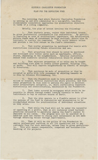
This one-page handwritten document lists several properties in the Ansonborough neighborhood. The document title indicates that the properties listed were under standard covenants with no restrictions on density or use.
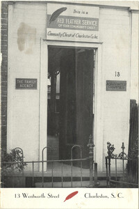
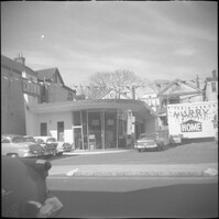
A photograph of the doorway leading into 13 Wentworth Street printed on a publication for the Red Feather Service of the Community Chest of Charleston Co. Inc.
View of Charleston from rooftop in the vicinity of northeast corner of Meeting and Wentworth Streets, facing northeast. Page 4, Photo 2 of collection. 3.5" x 3.5" B/W photograph.
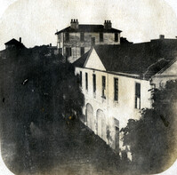
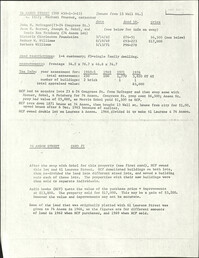
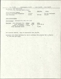
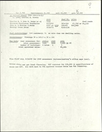
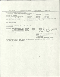
This two-page typed document describes a tour of Ansonborough Rehabilitation Project houses, including: 55 Laurens Street, the James Jervey House; 44 Society Street; 42 Society Street; 329 East Bay Street, the Gadsden House; and 332 East Bay Street, the Primerose House. Also includes information about other houses sold in Ansonborough, including 43 Society Street and houses on Laurens and Wentworth Streets.
This three-page typed document describes a tour of Ansonborough Rehabilitation Project houses, including: 42 Society Street; 44 Society Street; 329 East Bay Street, the Gadsden House; 332 East Bay Street, the Primerose House; and 55 Laurens Street, the James Jervey House. Includes information about the Ansonborough Rehabilitation Project committee and its members.
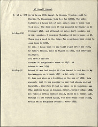
This one-page typed document, is a compilation of notes from an investigation into the ownership history of the property at 45 Hasell Street, tracing the property deed back to 1837.
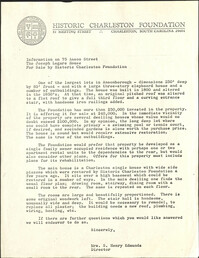
In this one-page typed document, Historic Charleston Foundation Director Mrs. S. Henry Edmunds provides a thorough description of 75 Anson Street, The Joseph Legare House, and the accompanying outbuildings, all of which were for sale at the time. Recommended renovations for the property and buildings are included.
View of Charleston from rooftop of Calhoun Mansion, facing north. Page 3, Photo 2 of collection. 5.5" x 3.75" B/W photograph, two images spliced together.
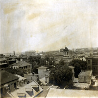
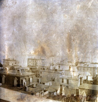
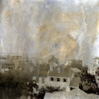
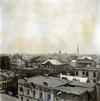
View of Charleston from rooftop at northeast corner of Wentworth and Meeting Streets, facing northwest. Buildings in image include Charleston Orphan House, Shirras Dispensary, St. Matthews Lutheran Church, and Trinity Methodist Church. Page 2, Photo 1 of collection. 3.5" x 3.5" B/W photograph.
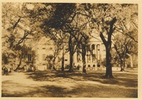
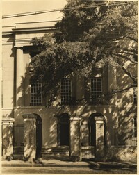
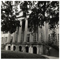
Photograph of front of Randolph Hall and the cistern yard. Towell Library on left. Construction of Randolph Hall, the most recognizable building at the College, began in 1828 under the direction of architect William Strickland. Flanking wings and portico for the main building were designed by Edward Brickell White and erected circa 1850. In 1886 the wings were destroyed by the Charleston earthquake and rebuilt between 1888 to 1894 under the direction of Gabriel Manigault.
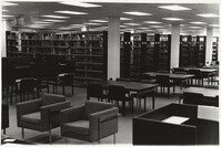
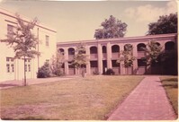
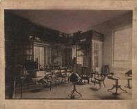
Photograph of the interior of the Robert Scott Small Library, 175 Calhoun St. Dedicated in 1972, the library was one of the first academic buildings constructed during the major expansion of the 1970's. Photograph taken prior to the addition of wings in 1975.
Photograph of the interior of the Robert Scott Small Library, 175 Calhoun St. Dedicated in 1972, the library was one of the first academic buildings constructed during the major expansion of the 1970's. Wings were added in 1975.
Photograph of the interior of the Robert Scott Small Library, 175 Calhoun St. Dedicated in 1972, the library was one of the first academic buildings constructed during the major expansion of the 1970's. Wings were added in 1975.
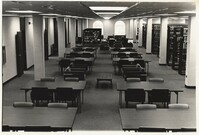
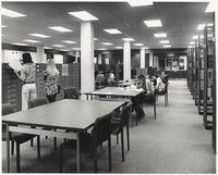
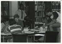
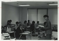
Photograph of students studying inside the library during a summer session. The Robert Scott Small Library, dedicated 1972, was one of the first academic buildings constructed during the major expansion of the 1970's. Wings were added in 1975.
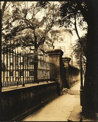
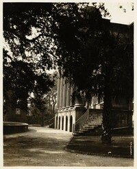
Partial view of east wing and St. Philip Street gate at Harrison Randolph Hall. Construction of Randolph Hall, the most recognizable building at the College, began in 1828 under the direction of architect William Strickland. Flanking wings and portico for the main building were designed by Edward Brickell White and erected circa 1850. In 1886 the wings were destroyed by the Charleston earthquake and rebuilt between 1888 to 1894 under the direction of Gabriel Manigault.
View of tower and St. Philip Street gate at Harrison Randolph Hall. Construction of Randolph Hall, the most recognizable building at the College, began in 1828 under the direction of architect William Strickland. Flanking wings and portico for the main building were designed by Edward Brickell White and erected circa 1850. In 1886 the wings were destroyed by the Charleston earthquake and rebuilt between 1888 to 1894 under the direction of Gabriel Manigault.
Exterior view of Craig Residence Hall and Union Dorm, 33 St. Philip St. Built in stages in 1962, 1970 and 1978, the Craig Cafeteria and Residence Hall originally included a student union and represented the College's first step in its expansion from the original main campus.
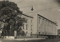
Exterior of the Willard A. Silcox Physical Education and Health Center, 20 George St. Built in 1939 as a WPA project, it served as the Athletic Center until 1985.
Knox-Lesesne House, 14 Green Way. Italianate style home built in 1846 by the widow of Walter Knox who had acquired the lot from the College. Alternately owned by Albert Jones, an African-American politician during Reconstruction, and later, Willie James Lesesne. The College purchased the home from Alberta S. Long in 1964.
Jonas Beard House, 114 Wentworth St. Built circa 1805 by Jonas Beard on glebe land leased from St. Philip's Church. The College acquired the house in 1975 from the grocery store proprietors who owned the property. The corner entrance was moved to the center of the structure during renovations.
72 George St. during renovation. Built circa 1837, this Greek Revival house was moved 90 degrees to make way for Physicians Auditorium. It has housed faculty offices since 1972.
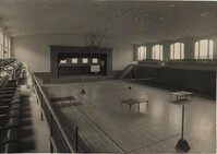
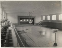
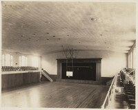
Interior of the Willard A. Silcox Physical Education and Health Center, 20 George St. Built in 1939 as a WPA project, it served as the Athletic Center until 1985.
Exterior of the Willard A. Silcox Physical Education and Health Center, 20 George St. Built in 1939 as a WPA project, it served as the Athletic Center until 1985.
Interior of the Willard A. Silcox Physical Education and Health Center, 20 George St. Built in 1939 as a WPA project, it served as the Athletic Center until 1985.
Interior of the Willard A. Silcox Physical Education and Health Center, 20 George St. Built in 1939 as a WPA project, it served as the Athletic Center until 1985.
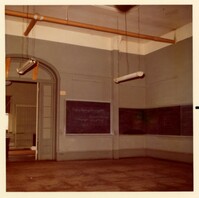
Photograph of a classroom inside of Randolph Hall. Construction of Randolph Hall, the most recognizable building at the College, began in 1828 under the direction of architect William Strickland. Flanking wings and portico for the main building were designed by Edward Brickell White and erected circa 1850. In 1886 the wings were destroyed by the Charleston earthquake and rebuilt between 1888 to 1894 under the direction of Gabriel Manigault.
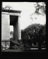
Side view of front of Randolph Hall. Construction of Randolph Hall, the most recognizable building at the College, began in 1828 under the direction of architect William Strickland. Flanking wings and portico for the main building were designed by Edward Brickell White and erected circa 1850. In 1886 the wings were destroyed by the Charleston earthquake and rebuilt between 1888 to 1894 under the direction of Gabriel Manigault.
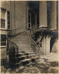
Photograph of steps in front of Randolph Hall. Construction of Randolph Hall, the most recognizable building at the College, began in 1828 under the direction of architect William Strickland. Flanking wings and portico for the main building were designed by Edward Brickell White and erected circa 1850. In 1886 the wings were destroyed by the Charleston earthquake and rebuilt between 1888 to 1894 under the direction of Gabriel Manigault.
Photograph of steps in front of Randolph Hall. Construction of Randolph Hall, the most recognizable building at the College, began in 1828 under the direction of architect William Strickland. Flanking wings and portico for the main building were designed by Edward Brickell White and erected circa 1850. In 1886 the wings were destroyed by the Charleston earthquake and rebuilt between 1888 to 1894 under the direction of Gabriel Manigault.
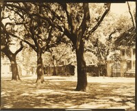
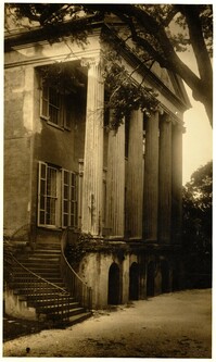
Photograph of front of Randolph Hall. Construction of Randolph Hall, the most recognizable building at the College, began in 1828 under the direction of architect William Strickland. Flanking wings and portico for the main building were designed by Edward Brickell White and erected circa 1850. In 1886 the wings were destroyed by the Charleston earthquake and rebuilt between 1888 to 1894 under the direction of Gabriel Manigault.
Photograph of front of Randolph Hall. Construction of Randolph Hall, the most recognizable building at the College, began in 1828 under the direction of architect William Strickland. Flanking wings and portico for the main building were designed by Edward Brickell White and erected circa 1850. In 1886 the wings were destroyed by the Charleston earthquake and rebuilt between 1888 to 1894 under the direction of Gabriel Manigault.
Knox-Lesesne House, 14 Green Way. Italianate style home built in 1846 by the widow of Walter Knox who had acquired the lot from the College. Alternately owned by Albert Jones, an African-American politician during Reconstruction, and later, Willie James Lesesne. The College purchased the home from Alberta S. Long in 1964.
On back of photograph: "Recitation room of Lewis R. Gibbes In College of Charleston, Charleston, S.C. 1838-1892." The 1892 date is crossed through with pencil and written below it is: "1886 (when altered due to earthquake damage)." Construction of Randolph Hall, the most recognizable building at the College, began in 1828 under the direction of architect William Strickland. Flanking wings and portico for the main building were designed by Edward Brickell White and erected circa 1850. In 1886 the wings were destroyed by the Charleston earthquake and rebuilt between 1888 to 1894 under the direction of Gabriel Manigault.