Page 203 of the City Engineer's Plat Book with one plat. An illustrated title card reads "A Plan of Charles Towne Copied with a Pen from an Old Dilapidated Plat without a Date," and depicts a harbor scene with Europeans and enslaved people. The plat labels landmarks and streets using capital and lowercase letters. These locations include Broad Street, the "State House," several churches, Boundary Street, the Exchange, an armory, and a beef market.
Page 214 of the City Engineer's Plat Book with two plats. Plat 1 shows lots located between Savage Street and Chisolm Street, and between Broad Street and Tradd Street. Plat 1 also shows Rutledge Avenue. Plat 2 shows a similar area to Plat 1, but also includes New Street, Franklin Street, Trapman Street, and Lynch Street.
Letter from James B. Edwards, Governor of South Carolina, to Septima P. Clark regardin the Advocacy Committee of the South Carolina Development Disabilities Council.
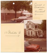
Two colored photographs of No. 17 Charlotte Street: Top left (structure located at the corner of Charlotte Street and Alexander Street); Bottom right (corner of front facade/south elevation and east elevation). The photographs are taped to a beige sheet of paper with two holes punched through the top. The photograph of No. 17 Charlotte Street is labeled "17 Charlotte St." The photograph of the neighboring structure is labeled "Corner of Charlotte and Alexander." The structure at No. 17 Charlotte Street is a two-and-a-half story Charleston Single style structure with a two story piazza. The exterior of the structure consists of white horizontal paneling with a pitched roof. The first story exterior of the facade includes a bay window with a sloped roof. The entryway leading onto the piazza is covered by a curved covering above the door. There is a transom above the entryway door and below the covering.
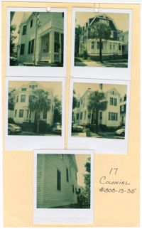
Five colored photographs of No. 17 Colonial Street and neighboring structures: Top left (north elevation of No. 17 Colonial Street); Top right (front facade/west elevation of the neighboring structure at No. 19 Colonial Street); Middle left (front facade/west elevation of the neighboring structure at No. 15 Colonial Street); Middle right (front facade/west elevation of No. 17 Colonial Street); Bottom (south elevation of No. 17 Colonial Street). The photographs are taped to a beige sheet of paper with two holes punched through the top. The paper is labeled "17 Colonial #808-13-35." There is a white border surrounding all five photographs. The structure at No. 17 Colonial Street is a two-and-a-half story structure with white horizontal exterior paneling. The neighboring structure at No. 15 Colonial Street is also a two-and-a-half story structure with white horizontal exterior paneling. Where the front facade is flat on No. 17 Colonial Street, there is a bay window at No. 15 Colonial Street. The neighboring structure at No. 19 Colonial Street is a three story Shingle style structure with a gambrel roof and dormer windows. The exterior siding consists of blue shingles on the third and second stories. The first story has white horizontal exterior paneling and a covered porch spanning the entire first story exterior.
Postcard of the Sword Gate at Simonton House in Charleston, S.C. Back of postcard reads, "The Simonton house at 32 Legare Street was built in 1776. These noted gates and gateway were placed here between 1815-1820. The sword gates are considered the finest examples of early wrought iron work."
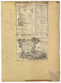
This is a Sandy Island plantation journal written inside of the South Carolina and Georgia Almanac for the year 1797. The plantation journal documents the planting of crops (rice, corn and potatoes), slave records (including runaway slaves), accounts, the weather, and business relations with Laurel Hill Plantation.