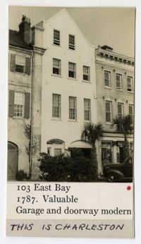
(Front) 5x8 index card survey of 101, 103, 105, and 107 Bull Street. Notes indicate the state of the dwellings. Includes thumbnail image of the dwellings.
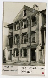
(Front) 5x8 index card survey of 99 and 101 Broad Street. Notes indicate the state of the dwelling. Includes thumbnail image of the dwelling. (Back) "Since survey The tile roof destroyed- The house altered for dwellings"
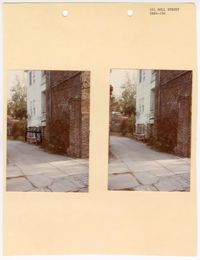
Two colored photographs of the side elevation of No. 101 Bull Street; Left (side elevation with black marks drawn around equipment); Right (side elevation). The two photographs are attached to a beige paper with two holes punched through the top. The paper is labeled as "101 Bull Street SR84-106." The photographs show the side elevation containing both a brick and panel exterior. The section of white horizontal paneling is separated from the brick by a white piazza. The photograph on the left has a handmade drawing that was made around the outdoor housing equipment.
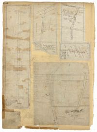
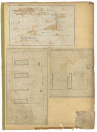
Page 101 of the City Engineer's Plat Book with two plats. Plat 1 shows lots located between Washington Street and Wharf Street, and between Calhoun Street and Laurens Street. Plat 2 shows lots located near the intersection of Rutledge Avenue and Line Street, with several buildings labelled.
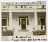
(Front) 5x8 index card survey of 102 Beaufain Street. Notes indicate the state of the dwelling. Includes two thumbnail images of the dwelling. (Back) Notes on building.
Page 102 of the City Engineer's Plat Book with five plats. Plat 1 shows lots along a stretch of Rutledge Avenue from Grove Street to Sans Souci Street. Plat 2 features a projected extension of Rutledge Avenue from Mt. Pleasant Road to Heriot Street, and also shows a lot labelled "S.C. Agricultural Society." Plat 3 shows a projected extension Rutledge Avenue, extending from Sans Souci Street to Mt. Pleasant Road. Plat 4 shows a projected expansion of Rutledge Avenue through Heriot Street, and also shows a plot labelled "Agricultural Society." Plat 5 shows a projected extension of Rutledge Avenue from Grove Street to Simons Street, and also shows King Street.
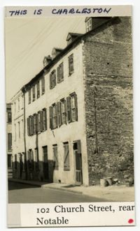
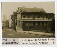
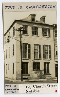
(Front) 5 x 8 index card with survey of 102, 106, and 110 Church Street. Includes one thumbnail image of dwelling. (Back) Signed by A.R.H.S., S.G.S., and A.S.
(Front) 5 x 8 index card with survey of 100 Church Street. Includes one thumbnail image of the building. (Back) Brief notes about the property, including a guess that the property belonged to "Rob't Millis's brother."
Comprehensive Employment and Training Act Title IV project application to the Manpower Division of the Office of the Governor of the State of South Carolina regarding a proposal request.
Page 103 of the City Engineer's Plat Book with three plats. Plat 1 shows lots located between President Street and Norman Street, near where they intersect with Spring Street. Plat 2 shows lots and some buildings along Bogard Street, between Laurel Street and Percy Street. Plat 3 shows a lot and several buildings located on Percy Street.
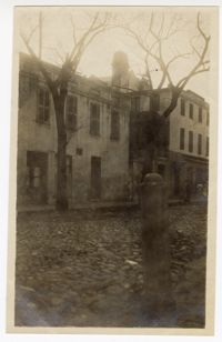
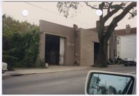
Colored photograph of No. 103 Spring Street. There are two holes punched through the top of the photograph. The photograph shows the cement block structure at No. 103 Spring Street. There is writing painted on beige walls of the north elevation identifying the structure as "Stanley's." There are large garage doors on both sides of the north elevation. The second garage door is slightly obstructed by the oak tree on the sidewalk. There is foliage growing along the west elevation. The photograph was taken from a vehicle. There is a rear view mirror in the bottom right corner of the photograph. The neighboring structures are also visible to the right of No. 103 Spring Street and in the rear view mirror.
Page 104 of the City Engineer's Plat Book with one plat. The plat shows lots located between Moultrie Street and Cunnington Street. It also shows Lemon Street, Lee Street, Price Street, and Magnolia Street. It also shows a plat labelled "Artilery Society" and another plat labelled "Magnolia Cemetery."
United States District Court for the District of South Carolina, Charleston Division, Civil Action No. 79-1042 Affidavit of Sheryl Smith, between Earl Davis, Jr. et al. (Plaintiff) versus The City of North Charleston et al. (Defendants).
United States District Court for the District of South Carolina, Charleston Division, Civil Action No. 79-1042 Notice of Filing Affidavits, between Earl Davis, Jr. et al. (Plaintiff) versus The City of North Charleston et al. (Defendants).
United States District Court for the District of South Carolina, Charleston Division, Civil Action No. 79-1042 Affidavit of Wayne Martin, between Earl Davis, Jr. et al. (Plaintiff) versus The City of North Charleston et al. (Defendants).
United States District Court for the District of South Carolina, Charleston Division, Civil Action No. 79-1042 Amended Complaint, between Earl Davis, Jr. et al. (Plaintiff) versus The City of North Charleston et al. (Defendants).
United States District Court for the District of South Carolina, Charleston Division, Civil Action No. 79-1042 Affidavit of John E. Bourne, Jr., between Earl Davis, Jr. et al. (Plaintiff) versus The City of North Charleston et al. (Defendants).
United States District Court for the District of South Carolina, Charleston Division, Civil Action No. 79-1042 Complaint, between Earl Davis, Jr. et al. (Plaintiff) versus The City of North Charleston et al. (Defendants).
United States District Court for the District of South Carolina, Charleston Division, Civil Action No. 79-1042 Affidavit of Thomas P. Stoney, II, between Earl Davis, Jr. et al. (Plaintiff) versus The City of North Charleston et al. (Defendants).
United States District Court for the District of South Carolina, Charleston Division, Civil Action No. 79-1042 Affidavit of James L. Bridges, between Earl Davis, Jr. et al. (Plaintiff) versus The City of North Charleston et al. (Defendants).
United States District Court for the District of South Carolina, Charleston Division, Civil Action No. 79-1042 Affidavit of Arthur Watson, between Earl Davis, Jr. et al. (Plaintiff) versus The City of North Charleston et al. (Defendants).
United States District Court for the District of South Carolina, Charleston Division, Civil Action No. 79-1042 Affidavit of Clerk, between Earl Davis, Jr. et al. (Plaintiff) versus The City of North Charleston et al. (Defendants).
United States District Court for the District of South Carolina, Charleston Division, Civil Action No. 79-1042 Affidavit of Earl Davis, between Earl Davis, Jr. et al. (Plaintiff) versus The City of North Charleston et al. (Defendants).
United States District Court for the District of South Carolina, Charleston Division, Civil Action No. 79-1042, between Earl Davis, Jr. et al. (Plaintiff) versus The City of North Charleston et al. (Defendants).
United States District Court for the District of South Carolina, Charleston Division, Civil Action No. 79-1042 Verification, between Earl Davis, Jr. et al. (Plaintiff) versus The City of North Charleston et al. (Defendants).
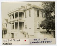
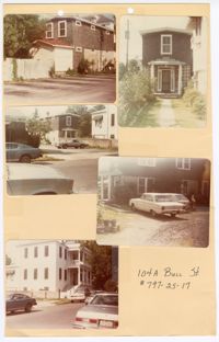
Five colored photographs of No. 104A Bull Street, the two-story outbuilding of No. 104 Bull Street: Top left (south elevation); Top right (front façade/north elevation); Middle left (north and east elevations from a distance); Middle right (west elevation); Bottom left (north and east elevations of No. 104 Bull Street). The five photographs are taped to a beige paper with two holes punched through the top. The paper is labeled "104A Bull St. #797-25-17." The outbuilding is a two-story structure. The exterior of the outbuilding consists of dark shingles and white ornamentation. No. 104 Bull Street is a Neoclassical style of architecture.
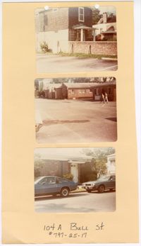
Three colored photographs of No. 104A Bull Street and its neighboring buildings to the west: Top (north and east elevations of No. 104A Bull Street); Middle (series of buildings located to the west of No. 104A Bull Street); (façade of building located to the west of No. 104A Bull Street). The three photographs are attached to a beige paper with two holes punched through the top. The paper is labeled "104A Bull St. #797-25-17." The outbuilding known as No. 104A Bull Street is a two-story structure. The exterior of the outbuilding consists of dark shingles and white ornamentation. The structures to the west of No. 104A Bull Street are single story brick structures.
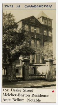
(Front) 5 x 8 index card with survey of 105 Drake Street. Includes three thumbnail images of dwelling. Notes indicate state of dwelling. (Back) Includes notes from Alice Huger Smith on "the general blight" of the neighborhood caused by the location of the Cigar Factory and railway yards, and how the city should have prevented the "degradation" with better zoning. Includes an image of the dwelling.
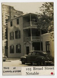
(Front) 5x8 index card survey of rear of 105 Broad Street. Notes indicate the state of the dwelling. Includes thumbnail image of the dwelling. (Back) Notes alterations to the structure.
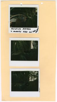
Three colored polaroid photographs of existing meters assumed to be located at No. 105 Bull Street: Top (existing meter); Middle (mark for new meter); Bottom (mark for new meter). The three photographs are attached to a beige paper with two holes punched through the top. There is writing in black ink on the top photograph indicating the existing meter. There are black marks on the middle and bottom photographs indicating the placement of the new meters. The paper is not labeled. The close up photographs each show large amounts of vegetation blocking the structure from view, limiting ability to confirm the address of the photographs.
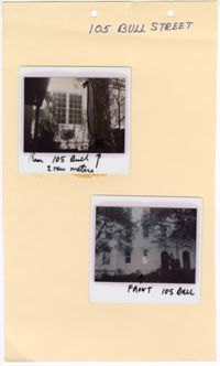
Two colored polaroid photographs of No. 105 Bull Street: Top (north elevation); Bottom (front façade/south elevation). The two photographs are attached to a beige paper with two holes punched through the top. The paper is labeled "105 Bull Street." The front facade of the structure indicates that No. 105 Bull Street is a blue row house. There are handwritten descriptions on each polaroid photograph. The top photograph has an arrow drawn within the photograph pointing upwards with a handwritten note indicating the new location for two meters. The handwritten label on the top photograph labels the photograph as “Rear 105 Bull.” The handwritten label on the bottom photograph labels the photograph as “Front 105 Bull.”
Page 105 of the City Engineer's Plat Book with seven plats. Plat 1 shows several lots located on Chalmers Street. Plat 2 shows lots located near the intersection of East Bay Street and Market Street, and several structures, including docs and wharves. Plat 3 features lots and structures located on Chalmers Street. Plat 4 features a lot located on the intersection of Church Street and Waters Street, and shows several structures. Plat 5 shows a lot and several structures located on Waters Street. Plat 6 features a lot and buildings located on Broad Street. Plat 7 features the profiles of streets where tidal drains will be built. The profiles include Calhoun Street, Mazyck Street, Logan Street, Tradd Street, Coming Street, Chesnut Street, Spring Street, and Meeting Street.
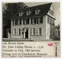
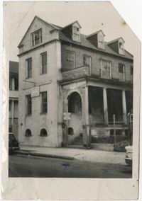
(Front) 5x8 index card survey of 106 Broad Street (John Lining House). Notes indicate the state of the dwelling. Includes two thumbnail images of the dwelling. (Back) Notes on John Lining and history of house.