This is the order book associated with the 4th South Carolina Regiment, which was established in November 1775 and formed part of the U.S. Continental Army between June 18, 1776 and January 1, 1781, when it was disbanded following the British capture of Charleston. It also contains orders relating to the 1st and 2nd South Carolina Regiments from September 15, 1775 onward, beginning with the capture of Fort Johnson. It discusses the allocation of men and material to various fortifications around the Charleston area, including Fort Sullivan, Fort Johnson, and the Grand Battery. The book accompanied Captain Barnard Elliott (d. 1778), who was reassigned from the 2nd to the 4th Regiment in November, 1775. Considerable reference is made to war plans, military discipline, including courts-martial, and camp life.
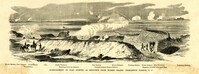
Caption: 'Bombardment of Fort Sumter, as sketched from Morris Island, Charleston Harbor, S.C.' Identified in image: Mortar Battery, Fort Johnson; James Island; City; Castle Pinckney; Fort Sumter; Mount Pleasant; Floating Battery; Mortar Battery; Fort Moultrie; Enfilading Battery; Iron Battery; Sand-bag cover for reserve; Traverse behind Trapier Battery and Magazine covered with sand bags.
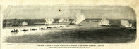
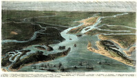
Caption: 'Panoramic view of Charleston Harbor--advance of iron-clads to the attack, April 7. Union--A. Keokuk. B. Nahunt. C. Nantucket. D. Catskill. E. Ironsides. F. Patapsco. G. Montauk. H. Passaie. K. Weehawken. Rebel--1. Morris Island sand battery. 2. Fort Wagner. 3. Battery Bee, on Cummings Point. 4. [Fort] Johnson. 5. Fort Ripley. 6. Sumter. 7. Charleston City. 8. Castle Pinckney. 9. Fort Redan. 10. Fort Moultrie. 11. Moultrie House. 12. Fort Beauregard. 13. Harbor obstructions. 14. Cooper River. 15. Ashley River.' [full date May 2, 1863.]
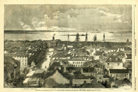
Caption: 'The city of Charleston, South Carolina.--[see page 62.]' Also identified in image: Broad Street, "Mercury" office, Custom-house, Castle Pinckney, Fort Moultrie, Fort Sumter and Morris Island. [full date January 26, 1861.]
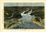
[Color image.] Caption (in French): 'Evenements des Etats-Unis: Charleston et ses fortifications. [Events of the United States: Charleston and its fortifications.] 1--Charleston. 2--Riviere Ashley [Ashley River]. 3--Chemin de fer de Savannah [Savannah Railway]. 4--Riviere Cooper [Cooper River]. 5--Riviere Wando [Wando River]. 6--Fort Pinkney [Castle Pinckney]. 7--Fort Ripley. 8--Fort Johnson (ile James) [James Island]. 9--Riviere Stone [Stono River]. 10--Fort Sumter. 11--Fort Moultrie. 12--Batterie Gregg (pointe de Gumming) [Battery Gregg (Cummings Point)]. 13--Fort Wagner. 14--Batteries rasantes du general Gilmore [grazed batteries of General Gilmore]. 15--Ouvrages pris par les federaux. [Works undertaken by the Federals]. 16--Phare Inlet [Lighthouse inlet]. 17--Batteries federales (ile Folly) [Federal Batteries (Folly Island)]. 18--Canonnieres et vaisseaux cuirasses [gunboats and ironclads]. 19--Hotel. 20--Ile et batteries Sullivan [Sullivan Island and Batteries]. 21--Moultrie. 22--Mont Pleasant [Mount Pleasant]. 23--Breach Inlet. 24--Shem Creek. 25--Batteries construite par les confederes sur l'ile James, dans le voisinage du fort Johnson [Batteries built by the Confederates on James Island, in the vicinity of Fort Johnson].
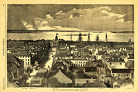
Caption: 'The city of Charleston, South Carolina, looking seaward, and showing the burned district.--[see next page.]' Identified in image are: Broad Street, "Mercury" office, Custom-house, Castle Pinckney, Fort Moultrie, Fort Sumter and Morris Island. [full date December 28, 1861.]
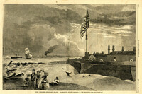
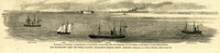
Caption: 'Our blockading fleet off North Channel, Charleston Harbor, South Carolina.--sketched by a Naval Officer.--[see page 79.] References--A. Fort Sumter.--B. Charleston City.--C. Fort Moultrie.--D. Rebel tug at work on the obstructions.--E. Obstructions.--F. Fort Johnson.--G. Mount Pleasant Batteries.' Also identified in image: South Carolina, Blunt, Daylight and Stars and Stripes (ships of the fleet). [full date January 31, 1863.]
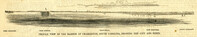
Caption: 'Profile view of the harbor of Charleston, South Carolina, showing the city and forts.' Identified in the image: Fort Johnston (sic), Fort Sumter, Charleston, Fort Moultrie and Mount Pleasant. [full date December 29, 1860.]
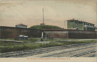
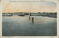
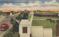
A postcard of the Parade Ground of Fort Moultrie. The back of the postcard reads, "The parade ground of Fort Moultrie, situated on Sullivan's Island was first called Fort Sullivan and later named after General Moultrie. It was originally built of palmetto logs and sand, and here Sergeant Jasper amidst shot and shell, jumped over parapets onto the beach, rescued the flag and put in place again."
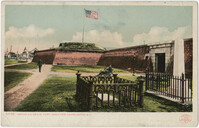
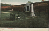
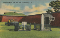
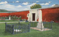
A postcard of the entrance of Fort Moultrie and the Grave of Osceola. Back of the postcard reads, "Osceola, a famous chief of the Seminole Indians, was born in Florida in 1803. His wife was seized as a slave in 1835, and he began a war which carried on until he was captured. He died in Fort Moultrie in 1837. Fort Moultrie, on Sullivan's Island, has figured extensively in history. During the Civil War the Fort was abandoned, when Charleston Harbor was evacuated in 1865."
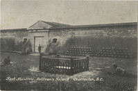
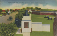
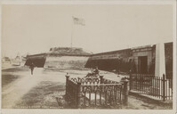
A postcard of the entrance to Fort Moultrie. The back of the postcard reads, "Fort Moultrie successfully defended the Harbor against the British Fleet under Sir Peter Parker. Th[illegible] shows the old guns left from past [illegible]ave of Osceola, famed Indian chief, [illegible] the modern coast artillery head-q[uarters]."
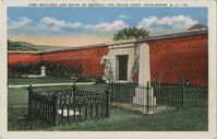
A postcard of Osceola's grave and entrance to Fort Moultrie. The back of the postcard reads: "Fort Moultrie successfully defended the harbor against the British fleet under Sir Peter Parker. It is now a modern Coast Artillery Defense and Army Post."
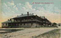
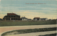
A postcard of the Post Quearters and Parade Ground of Old Fort Moultrie. Back of the postcard reads, "Fort Moultrie on Sullivans Island has figured extensively in history. During the Civil War, the Fort was abandoned, when Charleston Harbor was evacuated in 1865. It is now a modern Coast Atillery Headquarters."
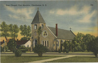
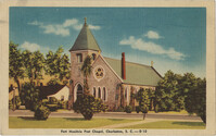
A postcard of the Post Chapel in Fort Moutlrie on Sullivan's Island. Back of the postcard reads, "Fort Moultrie on Sullivans island, has figured extensively in history. During the Civil War, the Fort was abandoned, when Charleston Harbor was evacuated in 1865. It is now a modern Coast Atillery Headquarters."
A postcard of the highway entrance to Fort Moultrie. The back of the postcard reads, "Shown in this view are the old guns left from past days, the grave of Osceola, famed Indian chief, and the road to the modern coast artillery headquarters. This Fort successfully defended the Harbor against the British Fleet under Sir Peter Parker."
A postcard of the Post Chapel in Fort Moutlrie. Back of the postcard reads, "Fort Moultrie on Sullivans island has figured extensively in history. During the Civil War, the Fort was abandoned, when Charleston Harbor was evacuated in 1865. It is now a modern Coast Atillery Headquarters."
Peggy Maginn Ferri shares her recollections of nearly 100 years living on Sullivan’s Island, including growing up in a house with 16 people, 9 of whom were children. She describes childhood activities that centered around the beach, playing ball, fishing and crabbing. Though she attended elementary school only a few blocks from her house, getting to high school in downtown Charleston required walking to the government dock, taking the ferry, and walking to Bishop England on Calhoun Street, an all day affair. Peggy speaks of her marriage to Ferdinand “Fergie” Ferri and their life together, both on and off the island. Much of Peggy’s life has been related to her family’s strong Catholic faith. Other anecdotes cover wine making, rum runners, and a famous island murder. Peggy ends with her statement that she has always considered herself a “girl of the island” having led an idyllic childhood, but notes her strong dislike for all the changes that have occurred on Sullivan’s Island.
Carl Smith and his wife, Stephanie, moved to Sullivan's Island in 1972 and immediately fell in love with it. Though an architect by profession, Carl soon became involved in island politics. His first involvement was on the Board of Adjustment, now known as the Board of Zoning Appeals. In those days there were basically no ordinances protecting historic structures on the island. However, there was the long established requirement for a minimum half acre lot size, something that Carl considers one of the most important aspects in protecting the island's character. In 1987 Carl was elected to Sullivan's Island Town Council. He was a council member during the destruction of Hurricane Hugo. He describes the devastation of the storm and the residents' return to the island. Hugo led to many changes, including the establishment of the island's first disaster plan. In the mid 90's Carl made his first run for mayor, but was defeated then and in 2001. His first successful bid for mayor came in 2005, and he ran unopposed in 2009. Carl feels that there were three issues that defined his time as Mayor of Sullivan's Island, in addition to his strong advocacy for preservation of the island's character. The first was that of the fate of the Ben Sawyer Bridge and the island's connection to the mainland. The second was the way in which water and sewer were handled on the island rather than being shipped to Mt. Pleasant. The third was the new Sullivan's Island Elementary School, a facility that Carl felt was ill-conceived and over-built. A referendum on the school was never allowed by Town Council, but the write-in vote on Carl's behalf in the mayoral election of 2013 was considered by many a referendum on the school. There are other accomplishments that Carl remembers with pride during his time as mayor including initiating an architectural survey of the island, designing the town sign at the entrance to the island, recovering and rehabilitating the old bandstand from Ft. Moultrie, erecting the monument in the historic town cemetery, and preserving the historic character of the Devereaux mansion gatehouse. Finally, Smith details his reasons for leaving the island.
The story of Rosamond Lawson's family connection with Sullivan's Island is the story of houses. Her great-great grandfather, German immigrant Charles Otto Witte, bought the first house at Station 18 in the late 1860's. That house ultimately burned, but a second house at Station 11, built in 1868, was bought in 1910 and remained in the family until 2018. Having moved from Charleston to Virginia when she was six, many of Rosamond's early memories are of summer visits. However, in 1994 she moved back to this area and spent many more years in the house with her own growing family. Summertime memories in the early years included crabbing, fishing, playing kickball, and entertaining Charleston friends. She learned to drive on the dirt road that ran along the back of the island. Rosamond recalls all the front beach homes being summer residences. Few people lived on Sullivan's Island year round, and those were not on front beach. Most houses, including her own, had neither heating nor air conditioning. On the rare visit to the island in the winter, the place was nearly deserted. There was a vegetable man who would come over every few days to deliver fresh produce. Rosamond recounts the few businesses that existed in those days. Playing hide and seek in the old batteries and Fort Moultrie before it became a National Park are all fond memories. Rosamond describes the typical summer thunderstorm and experiencing that in the old house. She also shows the damage done by Hurricane Hugo. Rosamond is also part of the Waring family. That includes Judge Waties Waring whose controversial decision became part of the famous Brown vs. Board of Education case leading to his ostracization and eventual move from Charleston to New York. Finally, Rosamond discusses her favorite memories as well as all the changes she has seen in the area over the past twenty-five years.
At one time there were so many Schirmers living on Sullivan's Island that the area around Station 19 and the Coast Guard Station earned the nickname, 'Schirmerville.' Ruth DeHaven is a member of that family that can trace its connection with the island back to the marriage of John Elias Schirmer to Helena Sass around 1800. Ruth's father as a young man would canoe to the island with his friends to spend time at a house called the 'Helluvajoint.' As a child, Ruth and her family would pack as many as eight or nine people into their car and as soon as school was out in the spring, drive to Sullivan's Island where they would stay until school started in the fall. Ruth goes on to detail many of the summertime activities she and her family engaged in, including fishing and crabbing on the rocks (jetties), shrimping in the creek, and swimming. After supper the adults usually turned to card games, often joined by 'Vincie' Coste, head of the Coast Guard Station. Other memories revolved around the Coast Guard including the bells that marked the hours, rescues of those in distress, and watching practices with breeches buoys. When the red hurricane flags went up, everyone plus dogs, chickens and goats loaded up the car and headed for Charleston. Ruth also covers relations with Ft. Moultrie, tensions during World War II, internment of German-Americans, disputes over which chickens laid which eggs, and lemon meringue pies. Her family was also close by when a runaway ship hit the Grace Memorial Bridge sending a car with five passengers to their death in 1946. The interview closes with Ruth's impression of the changes that have occurred on the island.