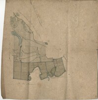
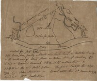
Farm of 54 across for sale by Rutherford, individual plots lettered A-S. Names associated with this plat are Birkman, Rutledge Phokes, Fitch, Kinsman and Rutherford. Notable geographic locations include Broad Street and Dorchester Road.
Office copy of a tract of land once belonging to Thomas Nau then John S. Cripps containing 277 1/2 acres. The land includes gum, white and red oak, and cedar trees along with posts, a rice field and a bridge over the public road from Rantoles [Rantowles] to Charleston. Names associated with this plat include John S. Cripps, Thomas Nau, and S. Lewis.
Plan of Belle Island north of Four Mile Creek consisting of 316 acres. Names associated with this plat are Middleton, Richard Lowndes, and W.R. Maxwell. Notable geographic locations include Belle Isle, Four Mile Creek, and Manquils Creek.
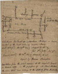
Copy of a plat of 250 acres laid out to Abraham Michau on the north side of Santee River and “now belonging to John Pedro." Names associated with this plat are Abraham Michau, John Pedro, George Hunter and James Glen. Notable geographic locations include the Santee River, Prince Frederick Parish and Georgetown District.
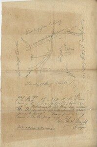
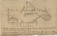
Plat of 53 acres off of Dorchester Road which is divided into lots. Very little details or information. Names associated with this plat are Fitch and Beckman. Notable geographic locations include Dorchester Road.
Resurvey of a tract of land measuring 510 acres called Egan Hall belonging to John Egan situated in St. James Parish, Santee. Names associated with this plat are John Egan, Gredless and Ball. Notable geographic locations include St. James Parish, Santee, Egan Hall, and Bunker's Hill.
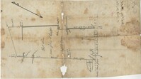
Sketch of property including roads and fields, some specific house names like Rectory house and W. Dotolhinese's house. Names associated with this plat are Glisbe, Priohau, Dotolhinese and Glebe. Notable geographic locations include St. Johns Parish, Broad Road, Wadboo [?] Bridge, Road to Pontauxs, and Road to Cordyville [?].
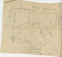
300 acre plot being partly marsh and highland in Colleton County, on the south side it is budding with the Stono River, shows surrounding property owners and minor creeks. Names associated with this plat are Robert Gibbes, Edward Fenwak, John Bremar and Bull.
Copy of a plat of 765 acres of high land and swamp and 98 acres of swamp along Pee Dee River. Names associated with this plat are Colonel Powell, Saxby, Richfield, Wood Furman and Broughton. Notable geographic locations include St. George Parish, the Pee Dee River, Churning Crop Road, Richfield Plantation, and Georgetown District.